
 Search
Official Long Range Thread 5.0
Page 8 of 40 •  1 ... 5 ... 7, 8, 9 ... 24 ... 40
 ![]()
Re: Official Long Range Thread 5.0
![]() by Frank_Wx Wed Dec 17, 2014 7:33 pm
by Frank_Wx Wed Dec 17, 2014 7:33 pm
Frank_Wx- Godzilla Seeker

- Posts : 21305
Join date : 2013-01-05 -

Re: Official Long Range Thread 5.0
![]() by jmanley32 Wed Dec 17, 2014 7:39 pm
by jmanley32 Wed Dec 17, 2014 7:39 pm
jmanley32- Senior Enthusiast

- Posts : 20516
Join date : 2013-12-12
Re: Official Long Range Thread 5.0
![]() by Guest Wed Dec 17, 2014 8:29 pm
by Guest Wed Dec 17, 2014 8:29 pm
Guest- Guest
Re: Official Long Range Thread 5.0
![]() by jmanley32 Wed Dec 17, 2014 8:47 pm
by jmanley32 Wed Dec 17, 2014 8:47 pm

jmanley32- Senior Enthusiast
- Posts : 20516
Reputation : 108
Join date : 2013-12-12
Age : 42
Location : Yonkers, NY
Re: Official Long Range Thread 5.0
![]() by Frank_Wx Wed Dec 17, 2014 8:56 pm
by Frank_Wx Wed Dec 17, 2014 8:56 pm
syosnow94 wrote:Why is a trend east bad? Does it have something to do with the cold air progged to come down after? Maybe I'm a little naive here but the further East the colder we are no?
A powerful storm that cuts into central or east-central Canada promotes higher heights over the NAO region as long as there is blocking in the Pacific, which there is. It's a mechanism to jump start blocking on thr Atlantic side.
_________________
_______________________________________________________________________________________________________
CLICK HERE to view NJ Strong Snowstorm Classifications

Frank_Wx- Godzilla Seeker
- Posts : 21305
Reputation : 328
Join date : 2013-01-05
Age : 31
Location : Jersey City, NJ -
Re: Official Long Range Thread 5.0
![]() by jmanley32 Wed Dec 17, 2014 11:16 pm
by jmanley32 Wed Dec 17, 2014 11:16 pm
jmanley32- Senior Enthusiast
- Posts : 20516
Reputation : 108
Join date : 2013-12-12
Age : 42
Location : Yonkers, NY
Re: Official Long Range Thread 5.0
![]() by Frank_Wx Wed Dec 17, 2014 11:23 pm
by Frank_Wx Wed Dec 17, 2014 11:23 pm
_________________
_______________________________________________________________________________________________________
CLICK HERE to view NJ Strong Snowstorm Classifications
Frank_Wx- Godzilla Seeker
- Posts : 21305
Reputation : 328
Join date : 2013-01-05
Age : 31
Location : Jersey City, NJ -
Re: Official Long Range Thread 5.0
![]() by jmanley32 Wed Dec 17, 2014 11:30 pm
by jmanley32 Wed Dec 17, 2014 11:30 pm
jmanley32- Senior Enthusiast
- Posts : 20516
Reputation : 108
Join date : 2013-12-12
Age : 42
Location : Yonkers, NY
Re: Official Long Range Thread 5.0
![]() by Frank_Wx Wed Dec 17, 2014 11:34 pm
by Frank_Wx Wed Dec 17, 2014 11:34 pm
_________________
_______________________________________________________________________________________________________
CLICK HERE to view NJ Strong Snowstorm Classifications
Frank_Wx- Godzilla Seeker
- Posts : 21305
Reputation : 328
Join date : 2013-01-05
Age : 31
Location : Jersey City, NJ -
Re: Official Long Range Thread 5.0
![]() by jmanley32 Thu Dec 18, 2014 12:24 am
by jmanley32 Thu Dec 18, 2014 12:24 am
jmanley32- Senior Enthusiast
- Posts : 20516
Reputation : 108
Join date : 2013-12-12
Age : 42
Location : Yonkers, NY
Re: Official Long Range Thread 5.0
![]() by Math23x7 Thu Dec 18, 2014 12:30 am
by Math23x7 Thu Dec 18, 2014 12:30 am
PS: Frank, did you complete your last college final yet?
Math23x7- Wx Statistician Guru

- Posts : 2379
Reputation : 68
Join date : 2013-01-08
Re: Official Long Range Thread 5.0
![]() by Frank_Wx Thu Dec 18, 2014 12:39 am
by Frank_Wx Thu Dec 18, 2014 12:39 am
Praise Mary Joseph Jesus
_________________
_______________________________________________________________________________________________________
CLICK HERE to view NJ Strong Snowstorm Classifications
Frank_Wx- Godzilla Seeker
- Posts : 21305
Reputation : 328
Join date : 2013-01-05
Age : 31
Location : Jersey City, NJ -
Re: Official Long Range Thread 5.0
![]() by Math23x7 Thu Dec 18, 2014 12:47 am
by Math23x7 Thu Dec 18, 2014 12:47 am
Frank_Wx wrote:Mike tomorrow at 11:30am
Praise Mary Joseph Jesus
Tomorrow as in Friday?
Math23x7- Wx Statistician Guru
- Posts : 2379
Reputation : 68
Join date : 2013-01-08
Re: Official Long Range Thread 5.0
![]() by Frank_Wx Thu Dec 18, 2014 1:04 am
by Frank_Wx Thu Dec 18, 2014 1:04 am
_________________
_______________________________________________________________________________________________________
CLICK HERE to view NJ Strong Snowstorm Classifications
Frank_Wx- Godzilla Seeker
- Posts : 21305
Reputation : 328
Join date : 2013-01-05
Age : 31
Location : Jersey City, NJ -
Re: Official Long Range Thread 5.0
![]() by HectorO Thu Dec 18, 2014 1:55 am
by HectorO Thu Dec 18, 2014 1:55 am

HectorO- Pro Enthusiast

- Posts : 959
Reputation : 27
Join date : 2013-01-11
Re: Official Long Range Thread 5.0
![]() by Frank_Wx Thu Dec 18, 2014 2:11 am
by Frank_Wx Thu Dec 18, 2014 2:11 am

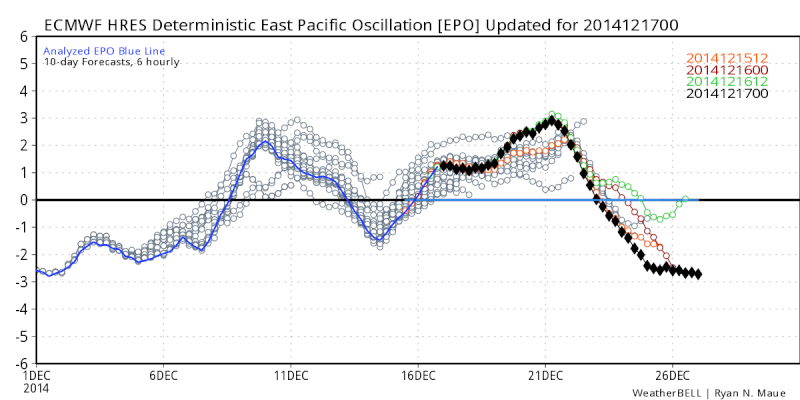
Not going to sugar coat it here..this was an ugly EURO run. Southeast ridge flexes it's muscle even during the 27th time frame. Granted there's no sense of getting worked up since this is well out in the long range, but I don't exactly like the euro and other guidance all showing this.
One thing I've noticed is the euro loves to overamplify short wave energy in the southwest US. You see those pressure falls south of AZ? Anytime you have impressive digging like that, it's going to amplify the southeast ridge.
This is a known bias of the euro model to dig too much energy in the southwest US. Hopefully that was the case thus run.
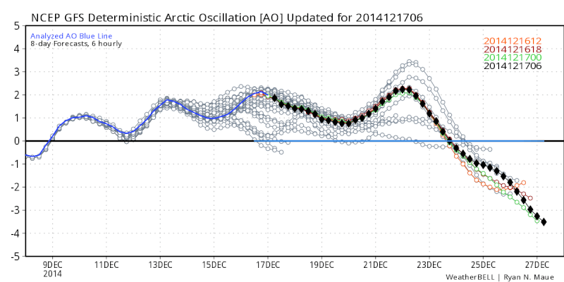
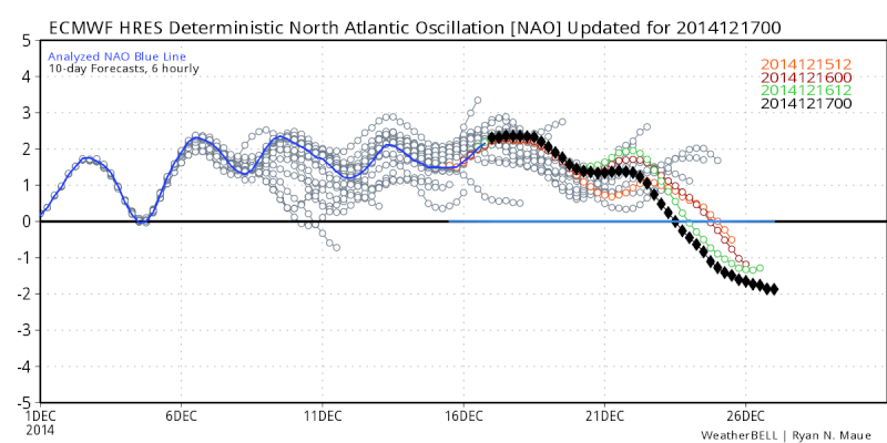
Also notice the -EPO/-NAO combo per the image above. That indicates to me a southeast ridge should not happen.
We'll see what happens. I'm hoping we can end this month with at least a minor snow event or a full on pattern change to lead us into January.
_________________
_______________________________________________________________________________________________________
CLICK HERE to view NJ Strong Snowstorm Classifications
Frank_Wx- Godzilla Seeker
- Posts : 21305
Reputation : 328
Join date : 2013-01-05
Age : 31
Location : Jersey City, NJ -
Re: Official Long Range Thread 5.0
![]() by docstox12 Thu Dec 18, 2014 5:03 am
by docstox12 Thu Dec 18, 2014 5:03 am
HectorO wrote:Imagine if December had the temps November did. With all the moisture we had this month, we could have had a lot of accumulation. Would have had a snowpack goin on.
Indeed but Mother Nature just corrected herself with the very cold November temps.I always get a bad feeling with these early season accumulating snows, 2011, 1989.Would rather have mild October and November's, even up to mid -December, then cold and snow.We'll see how this plays out this season.That indicator CP came up with is pretty accurate ("as December, goes the winter) and right now it's looking pretty bad.That model Frank just posted with the SE ridge bodes ill!

docstox12- Wx Statistician Guru
- Posts : 8504
Reputation : 222
Join date : 2013-01-07
Age : 73
Location : Monroe NY
Re: Official Long Range Thread 5.0
![]() by skinsfan1177 Thu Dec 18, 2014 5:07 am
by skinsfan1177 Thu Dec 18, 2014 5:07 am

skinsfan1177- Senior Enthusiast
- Posts : 4485
Reputation : 35
Join date : 2013-01-07
Age : 46
Location : Point Pleasant Boro
Re: Official Long Range Thread 5.0
![]() by docstox12 Thu Dec 18, 2014 5:11 am
by docstox12 Thu Dec 18, 2014 5:11 am
docstox12- Wx Statistician Guru
- Posts : 8504
Reputation : 222
Join date : 2013-01-07
Age : 73
Location : Monroe NY
Re: Official Long Range Thread 5.0
![]() by Radz Thu Dec 18, 2014 6:49 am
by Radz Thu Dec 18, 2014 6:49 am
docstox12 wrote:HectorO wrote:Imagine if December had the temps November did. With all the moisture we had this month, we could have had a lot of accumulation. Would have had a snowpack goin on.
Indeed but Mother Nature just corrected herself with the very cold November temps.I always get a bad feeling with these early season accumulating snows, 2011, 1989.Would rather have mild October and November's, even up to mid -December, then cold and snow.We'll see how this plays out this season.That indicator CP came up with is pretty accurate ("as December, goes the winter) and right now it's looking pretty bad.That model Frank just posted with the SE ridge bodes ill!
I agree, early snows don't seem to usually precede banner snowfall years, but even with that ugly Euro run, hoping we can pull this year out! But if a parade of GLC's really does come to fruition, i won't be too optimistic of a pattern change to a favorable snow producing Jan-Feb… fingers crossed the 27th time frame yields accumulating snow!

Radz- Pro Enthusiast
- Posts : 1028
Reputation : 17
Join date : 2013-01-12
Location : Cortlandt Manor NY
Re: Official Long Range Thread 5.0
![]() by sroc4 Thu Dec 18, 2014 7:22 am
by sroc4 Thu Dec 18, 2014 7:22 am
Whats your point sroc? I and many others on here have always preached that when there is a transitional period to the pattern the models will struggle mightily in the long and medium range. Right now when I step back with my cup of coffee it looks like the upper levels are in an epic battle. The -EPO (blocking over Alaska) wants to re-establish itself after Xmas.
 " />
" /> " />
" />The -AO (unlocking of the cold air from way up north) wants to re-establish itself after Xmas.
 " />
" /> " />
" />The -NAO (blocking over Greenland) is trying ever so hard to show up....after Xmas.
 " />
" />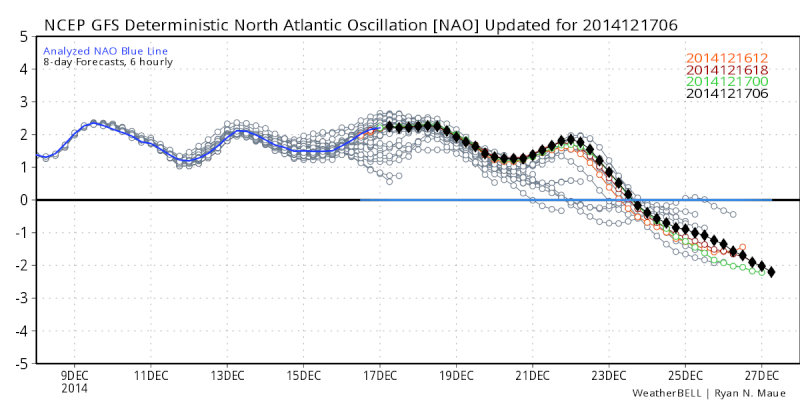 " />
" /> -EPO promotes the jet stream to ride up and over Alaska and dive into Canada and into the CONUS only after picking up cold canadaian air masses. The -AO loosens its grip on the arctic air masses allow it to further want to head south towards the CONUS. The -NAO sets up a block to our N and E overGreenland which typically promotes the flow off our coast to slow down allowing that cold air to build into the east and energy to consolidate along the coast leading to more potent systems along the coast. ALL good things right???
BUT...there are also a few other atmospheric components that seem to be resisting.
The PNA (ridge in the western CONUS) is still struggling to come out of the negative phase after Xmas. But hasn't it been in the + phase which is what we want. Yes, but all the other Teles have not been in the favorable phases. (+EPO, +AO, +NAO).
 " />
" /> " />
" />The MJO wants to come out of the COD and have another go round through phases 3,4, and 5 which are typically known as warm phases in the east.
Euro and Ens

GEF Ens

Canadian

Ukmet:

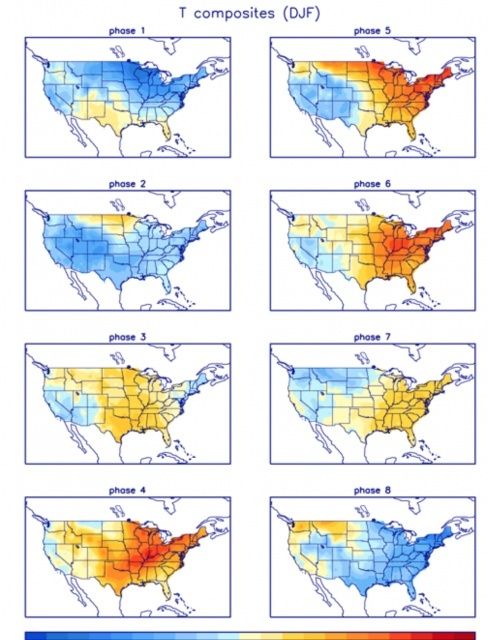
Here is the image which typically shows the temperature anomalies for any given phase of the MJO for the months of Dec Jan and Feb. For instance typically when the MJO is in phase 5 and 6 the eastern half of the CONUS is in orange or above normal temp pattern.
 " />
" />If the PNA stays neg does this mean that despite the -EPO can our polar disturbances dig enough to get into the EC and ride the coast or do they cut to our west or slide harmlesly OTS to our S as we are seeing with this Sundays potential??
The problem here is that once again it is all in the long range right now. All of these large general weather pattern phenomenon are battling against one another creating what is our overall pattern. Do we remain in a state of flux all winter because of the constant battle or do some of the above features win out and the upperlevel pattern "locks" in and we get some consistency for an extended period. I personally believe that we will get the -EPO, -AO, -NAO pattern that wwill ultimately win out. But say for instance the MJO on the Euro comes to fruition. Its showing not only phases 3, 4 and 5 but it shows them strongly in those octanes. That would indeed promote the SE ridge formation as seen in the LR model projections. Conversely if the GEFs come to fruition it is showing the same state of the MJO but much weaker in those Octanes which would mean less influence over the Eastern CONUS where the -EPO, -AO, -NAO could win out which promote cold and stormy in the E.
Deep breath and...............mother nature is truly testing all of our patience. The models WILL struggle in the LR and MR unless we can truly lock into a pattern; then I believe they may become more reliable. For now Look at the LR and MR, and cont to take it with a grain of salt whether it shows something you want to see or don't want to see. This season should be a very interesting one to analyze after the fact.
_________________
"In weather and in life, there's no winning and losing; there's only winning and learning."
WINTER 2012/2013 TOTALS 43.65"WINTER 2017/2018 TOTALS 62.85" WINTER 2022/2023 TOTALS 4.9"
WINTER 2013/2014 TOTALS 64.85"WINTER 2018/2019 TOTALS 14.25" WINTER 2023/2024 TOTALS 13.1"
WINTER 2014/2015 TOTALS 71.20"WINTER 2019/2020 TOTALS 6.35"
WINTER 2015/2016 TOTALS 35.00"WINTER 2020/2021 TOTALS 37.75"
WINTER 2016/2017 TOTALS 42.25"WINTER 2021/2022 TOTALS 31.65"

sroc4- Admin
- Posts : 8331
Reputation : 301
Join date : 2013-01-07
Location : Wading River, LI
Re: Official Long Range Thread 5.0
![]() by HectorO Thu Dec 18, 2014 8:01 am
by HectorO Thu Dec 18, 2014 8:01 am
docstox12 wrote:I wonder what the pattern was going into the 1995-1996 killer winter we had here.There was snowpack from late-November to early April.Seems to me you want the favorable pattern locked in by late November and not have to keep pushing it further and further down the line.
This is what I was trying to get at in the other threads, I wasn't trying to get anyone worked up I was just saying it's better to see some light earlier than later. December 1 we already pretty much canceled out the whole month amd waiting for January. We wait 3-4 weeks for a change if that doesn't happen in January then adios. Dec 24th looks interesting. Could be some thunderstorms for Christmas lol. And yes 11/12 was awful.
HectorO- Pro Enthusiast
- Posts : 959
Reputation : 27
Join date : 2013-01-11
Re: Official Long Range Thread 5.0
![]() by docstox12 Thu Dec 18, 2014 8:14 am
by docstox12 Thu Dec 18, 2014 8:14 am
This year the patterns are like trying to chase and catch a butterfly.Just when you reach it and think you've got it, it takes off again.Frustrating to say the least.
docstox12- Wx Statistician Guru
- Posts : 8504
Reputation : 222
Join date : 2013-01-07
Age : 73
Location : Monroe NY
Re: Official Long Range Thread 5.0
![]() by Guest Thu Dec 18, 2014 8:44 am
by Guest Thu Dec 18, 2014 8:44 am
docstox12 wrote:I wonder what the pattern was going into the 1995-1996 killer winter we had here.There was snowpack from late-November to early April.Seems to me you want the favorable pattern locked in by late November and not have to keep pushing it further and further down the line.
Exactly what I've been saying since I joined this forum. In a nutshell screw science and models. If we get cold and snow early it sets the stage and we get future storms and corresponding weather. The snowcover lowers temps and storms follow the same path. We haven't had that and I would Respectfully point out that many forecasts of upcoming storms and cold potential keep busting and being delayed. docstox12 put my feelings into words perfectly!!
Guest- Guest
Re: Official Long Range Thread 5.0
![]() by HectorO Thu Dec 18, 2014 8:45 am
by HectorO Thu Dec 18, 2014 8:45 am
HectorO- Pro Enthusiast
- Posts : 959
Reputation : 27
Join date : 2013-01-11
Re: Official Long Range Thread 5.0
![]() by HectorO Thu Dec 18, 2014 8:56 am
by HectorO Thu Dec 18, 2014 8:56 am
syosnow94 wrote:docstox12 wrote:I wonder what the pattern was going into the 1995-1996 killer winter we had here.There was snowpack from late-November to early April.Seems to me you want the favorable pattern locked in by late November and not have to keep pushing it further and further down the line.
Exactly what I've been saying since I joined this forum. In a nutshell screw science and models. If we get cold and snow early it sets the stage and we get future storms and corresponding weather. The snowcover lowers temps and storms follow the same path. We haven't had that and I would Respectfully point out that many forecasts of upcoming storms and cold potential keep busting and being delayed. docstox12 put my feelings into words perfectly!!
Talking about a pattern lock not really early snow. Early snow has been a curse for us over the past few decades. 2011 is an example. I think we were all spoiled by 08/09, 09/10 and 10/11. Those were 3 great years. I think this winter will resemble 11/12 but not as mild or snowless.
HectorO- Pro Enthusiast
- Posts : 959
Reputation : 27
Join date : 2013-01-11
Re: Official Long Range Thread 5.0
![]() by GreyBeard Thu Dec 18, 2014 9:07 am
by GreyBeard Thu Dec 18, 2014 9:07 am
Don't see any more posts on pattern changes that Frank was hyping and his blog describing why that was going to occur has mysteriously disappeared.(either that or I can't find it).
Guys are saying wait until mid January or even February 'til things start happening.We shall see.
As I said I'm more of an observer here than a poster, but that's the vibe I'm getting. I'm also not it the best of moods as I took a fall in the shower Monday night and fractured rib #6 in the back. It hurts just to breathe. Wouldn't wish this on anybody,but on the up side, I've got more time to study the board as I recuperate. Sorry for the rant, regards and best wishes to all.
GreyBeard- Senior Enthusiast
- Posts : 725
Reputation : 34
Join date : 2014-02-12
Location : eastern nassau county
Page 8 of 40 • 1 ... 5 ... 7, 8, 9 ... 24 ... 40 ![]()
|
|
|