
 Search
Official Long Range Thread 6.0
Page 12 of 40 •  1 ... 7 ... 11, 12, 13 ... 26 ... 40
 ![]()
Re: Official Long Range Thread 6.0
![]() by Frank_Wx Wed Jan 28, 2015 1:42 am
by Frank_Wx Wed Jan 28, 2015 1:42 am

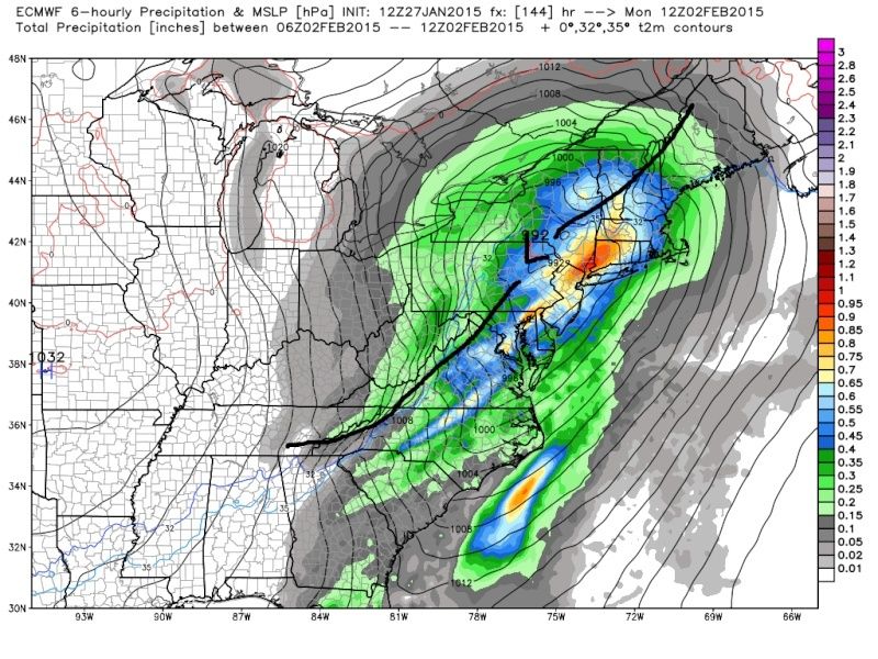
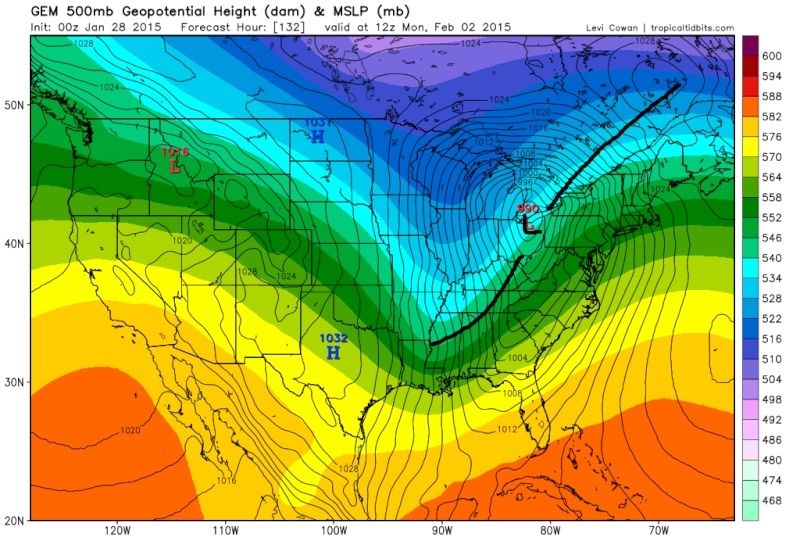
The euro keeps the storm track south and NYC Metro sees close to a foot of snow thus run. Heres the scenarios:
1. The northern and southern stream energies remain un-phased and this becomes a SWFE. With confluence in SE Canada thanks to the Friday clipper deepening with a PV in an ideal location in east-central Canada, that creates enough of a confluence or block to prevent the storm from cutting northwest. Instead, it's a SWFE and the tricky part becomes where the baroclinic zone, or temp. gradient, sets up. These setups could yield big snowfalls for some locations, but really screw over those on the wrong side of the gradient. Very thread the needle types.
2. The confluence in Canada is weak and the storm has room to cut west. This scneario would bring many places rain. This scenario is likely to happen if a phase is realized. Too early, the storm deepens and cuts.
3. This scenario isn't shown yet and I doubt we worry about but would be a Miller B that most likely benefits just New England. A phase just before reaching the coast but the confluence is still good in Canada, so energy is forced to transfer off the coast.
Here are your three scenarios for Monday. We'll get an idea of how this shapes up by the weekend.
Frank_Wx- Godzilla Seeker

- Posts : 21305
Join date : 2013-01-05 -

Re: Official Long Range Thread 6.0
![]() by algae888 Wed Jan 28, 2015 2:33 am
by algae888 Wed Jan 28, 2015 2:33 am


algae888- Advanced Forecaster

- Posts : 5311
Join date : 2013-02-05
Re: Official Long Range Thread 6.0
![]() by algae888 Wed Jan 28, 2015 2:37 am
by algae888 Wed Jan 28, 2015 2:37 am


algae888- Advanced Forecaster
- Posts : 5311
Reputation : 46
Join date : 2013-02-05
Age : 61
Location : mt. vernon, new york
Re: Official Long Range Thread 6.0
![]() by docstox12 Wed Jan 28, 2015 6:39 am
by docstox12 Wed Jan 28, 2015 6:39 am
Frank_Wx wrote:
The euro keeps the storm track south and NYC Metro sees close to a foot of snow thus run. Heres the scenarios:
1. The northern and southern stream energies remain un-phased and this becomes a SWFE. With confluence in SE Canada thanks to the Friday clipper deepening with a PV in an ideal location in east-central Canada, that creates enough of a confluence or block to prevent the storm from cutting northwest. Instead, it's a SWFE and the tricky part becomes where the baroclinic zone, or temp. gradient, sets up. These setups could yield big snowfalls for some locations, but really screw over those on the wrong side of the gradient. Very thread the needle types.
2. The confluence in Canada is weak and the storm has room to cut west. This scneario would bring many places rain. This scenario is likely to happen if a phase is realized. Too early, the storm deepens and cuts.
3. This scenario isn't shown yet and I doubt we worry about but would be a Miller B that most likely benefits just New England. A phase just before reaching the coast but the confluence is still good in Canada, so energy is forced to transfer off the coast.
Here are your three scenarios for Monday. We'll get an idea of how this shapes up by the weekend.
Excellent, Frank.
Looks like EURO and GFS keeps this a snow maker but CMC cuts it to rain.Clipper coming in with an inch or so Thu-Fri. We'll see how that system sets the stage for Sun.

docstox12- Wx Statistician Guru

- Posts : 8502
Reputation : 222
Join date : 2013-01-07
Age : 73
Location : Monroe NY
Re: Official Long Range Thread 6.0
![]() by CPcantmeasuresnow Wed Jan 28, 2015 7:16 am
by CPcantmeasuresnow Wed Jan 28, 2015 7:16 am
I'll leave this to our experts. I'm not touching it.

CPcantmeasuresnow- Wx Statistician Guru
- Posts : 7274
Reputation : 230
Join date : 2013-01-07
Age : 103
Location : Eastern Orange County, NY
Re: Official Long Range Thread 6.0
![]() by docstox12 Wed Jan 28, 2015 7:18 am
by docstox12 Wed Jan 28, 2015 7:18 am
docstox12- Wx Statistician Guru
- Posts : 8502
Reputation : 222
Join date : 2013-01-07
Age : 73
Location : Monroe NY
Re: Official Long Range Thread 6.0
![]() by sroc4 Wed Jan 28, 2015 7:25 am
by sroc4 Wed Jan 28, 2015 7:25 am
Frank_Wx wrote:00z GFS for the Monday system next week went north, so lots of rain
It's a blizzard for Alex though (Alex, mother nature may make this up to you for not being home yesterday)

12z Euro yesterday agreed with the LP cutting like the 00z GFS did last night(see above);
 " />
" />HOWEVER;
Euro came back in with a track off the Delmarva S of LI
 " />
" />The Euro ensemble Mean is South of LI as well. The blue dot is the mean. I have circled the various clusters of members. Clearly the overwhelmingly majority of members takes the track S of LI. If we don't want rain, esp for the coast this has to happen.
 " />
" />Here is the latest 6z GFS Ensemble forecast track, again S of LI. (FWIW the 00z GFS Ens was S as well)
 " />
" />Th GLC the cmc showed overnight is pretty much not going to happen unless there is a MAJOR shift in all other operational and Ensemble guidance. The cmc Ens forecast is not even close to this:
CMC OPERATIONAL
 " />
" />CMC Ens Mean
 " />
" />As of now a track S of LI is probably a safe bet; however, since we are all seasoned veterans now we know there is a long way to go. Ill have a write up later in the week looking at the upper air set up which will determine the track. Keep it south of LI or allow it to cut/coastal hugger? We will examine the H5 maps over the Hudson bay and the Canadian maritime to the E of the Hudson bay to get the answer. We must not forget the pattern to our west as well, but will prob play less of a role in this set up as things stand now.
_________________
"In weather and in life, there's no winning and losing; there's only winning and learning."
WINTER 2012/2013 TOTALS 43.65"WINTER 2017/2018 TOTALS 62.85" WINTER 2022/2023 TOTALS 4.9"
WINTER 2013/2014 TOTALS 64.85"WINTER 2018/2019 TOTALS 14.25" WINTER 2023/2024 TOTALS 13.1"
WINTER 2014/2015 TOTALS 71.20"WINTER 2019/2020 TOTALS 6.35"
WINTER 2015/2016 TOTALS 35.00"WINTER 2020/2021 TOTALS 37.75"
WINTER 2016/2017 TOTALS 42.25"WINTER 2021/2022 TOTALS 31.65"

sroc4- Admin
- Posts : 8331
Reputation : 301
Join date : 2013-01-07
Location : Wading River, LI
Re: Official Long Range Thread 6.0
![]() by CPcantmeasuresnow Wed Jan 28, 2015 7:45 am
by CPcantmeasuresnow Wed Jan 28, 2015 7:45 am
Thanks as always for making it understandable.
CPcantmeasuresnow- Wx Statistician Guru
- Posts : 7274
Reputation : 230
Join date : 2013-01-07
Age : 103
Location : Eastern Orange County, NY
Re: Official Long Range Thread 6.0
![]() by Analog96 Wed Jan 28, 2015 7:46 am
by Analog96 Wed Jan 28, 2015 7:46 am
It's a Miller A system and will be on the maps all the way from the Southwestern US.
Analog96- Meteorologist

- Posts : 156
Reputation : 1
Join date : 2014-03-12
Location : Elizabeth, NJ
Re: Official Long Range Thread 6.0
![]() by amugs Wed Jan 28, 2015 8:04 am
by amugs Wed Jan 28, 2015 8:04 am
1 Euro OP is an all out snowstorm
2. The Ensemble mean takes LP south and to the BM
3 The usually amped control is south of both
4 The 6z GEFS is cold and all snow
5. The 6z GFS OP is further S that the 0z GFS OP .
Okay another system Feb 5th time frame as well. Lets get some model agreement and be patient on this next one. Nice air mass in place unlike the stale one we had this past Saturday and I got 8" out of it - go figure.
_________________
Mugs
AKA:King: Snow Weenie
Self Proclaimed
WINTER 2014-15 : 55.12" +.02 for 6 coatings (avg. 35")
WINTER 2015-16 Total - 29.8" (Avg 35")
WINTER 2016-17 : 39.5" so far

amugs- Advanced Forecaster - Mod

- Posts : 15093
Reputation : 213
Join date : 2013-01-07
Age : 54
Location : Hillsdale,NJ
Re: Official Long Range Thread 6.0
![]() by Grselig Wed Jan 28, 2015 8:05 am
by Grselig Wed Jan 28, 2015 8:05 am

Grselig- Senior Enthusiast

- Posts : 1408
Reputation : 140
Join date : 2013-03-04
Age : 54
Location : Wayne NJ
Re: Official Long Range Thread 6.0
![]() by amugs Wed Jan 28, 2015 8:06 am
by amugs Wed Jan 28, 2015 8:06 am
Analog96 wrote:One thing about this storm is it will definitely be easier to track and the odds of having a storm are high.
It's a Miller A system and will be on the maps all the way from the Southwestern US.
Great point Greg - we have always had the issue with Miller B's of when and where the phase will occur - they can surprise you either way as we all just learned. As long as Frank pointed out we do not get a phased bomb then we should be good to go.
_________________
Mugs
AKA:King: Snow Weenie
Self Proclaimed
WINTER 2014-15 : 55.12" +.02 for 6 coatings (avg. 35")
WINTER 2015-16 Total - 29.8" (Avg 35")
WINTER 2016-17 : 39.5" so far
amugs- Advanced Forecaster - Mod
- Posts : 15093
Reputation : 213
Join date : 2013-01-07
Age : 54
Location : Hillsdale,NJ
Re: Official Long Range Thread 6.0
![]() by Analog96 Wed Jan 28, 2015 8:37 am
by Analog96 Wed Jan 28, 2015 8:37 am
amugs wrote:Analog96 wrote:One thing about this storm is it will definitely be easier to track and the odds of having a storm are high.
It's a Miller A system and will be on the maps all the way from the Southwestern US.
Great point Greg - we have always had the issue with Miller B's of when and where the phase will occur - they can surprise you either way as we all just learned. As long as Frank pointed out we do not get a phased bomb then we should be good to go.
Miller B's tend to benefit Eastern New England the most, even when we do get a big event out of one.
Analog96- Meteorologist
- Posts : 156
Reputation : 1
Join date : 2014-03-12
Location : Elizabeth, NJ
Re: Official Long Range Thread 6.0
![]() by jmanley32 Wed Jan 28, 2015 8:44 am
by jmanley32 Wed Jan 28, 2015 8:44 am

jmanley32- Senior Enthusiast
- Posts : 20513
Reputation : 108
Join date : 2013-12-12
Age : 42
Location : Yonkers, NY
Re: Official Long Range Thread 6.0
![]() by docstox12 Wed Jan 28, 2015 8:44 am
by docstox12 Wed Jan 28, 2015 8:44 am
docstox12- Wx Statistician Guru
- Posts : 8502
Reputation : 222
Join date : 2013-01-07
Age : 73
Location : Monroe NY
Re: Official Long Range Thread 6.0
![]() by Analog96 Wed Jan 28, 2015 8:46 am
by Analog96 Wed Jan 28, 2015 8:46 am
jmanley32 wrote:Interesting on how the ensembles are so different than the operational, def one to watch Euro run would be nice but the Euro has really goota come back with a vengeance. However what Alex said was totally true it did not get all areas wrong for snow totals basically NYC and west was the fail. Busy today classes start so I will be on when I can. Have a great one!
The EURO tends to do better with Miller A systems.
However, I need to see some consistency from it before I hug it.
Analog96- Meteorologist
- Posts : 156
Reputation : 1
Join date : 2014-03-12
Location : Elizabeth, NJ
Re: Official Long Range Thread 6.0
![]() by amugs Wed Jan 28, 2015 9:06 am
by amugs Wed Jan 28, 2015 9:06 am
Analog96 wrote:jmanley32 wrote:Interesting on how the ensembles are so different than the operational, def one to watch Euro run would be nice but the Euro has really goota come back with a vengeance. However what Alex said was totally true it did not get all areas wrong for snow totals basically NYC and west was the fail. Busy today classes start so I will be on when I can. Have a great one!
The EURO tends to do better with Miller A systems.
However, I need to see some consistency from it before I hug it.
Greg,
i sated this numerous times that EURO handles Southern Vorts/Systems much better than the GFS and the GFS handles Northern Vorts better - some way built into the algorithms of each computer. That being said the evolution of last storm was so dynamic and hair line that was we saw each got something correct. You are absolutely right that we do not fair well from Miller B's but Miller A much better so let's nail this one and the model I ma hugging is my wife - HAHAHA!! My "new" method is going by ensembles and their mean over the OP's going forward.
This from NWS
SMALL WINTER WEATHER EVENT IS EXPECT ON THURSDAY NIGHT INTO
FRIDAY FOLLOWED BY VERY COLD WEATHER. SEE THE AREA FORECAST
DISCUSSION FOR ADDITIONAL INFORMATION.
YE ANOTHER LOW PRESSURE SYSTEM IS FORECAST TO AFFECT THE REGION
SUNDAY NIGHT INTO MONDAY. UNCERTAINTY IN THE FORECAST TRACK FOR
THIS SYSTEM IS HIGH AT THIS TIME. IT APPEARS THE MOST LIKELY TRACK
FOR THE LOW IS TO THE SOUTH OF THE REGION. THIS WOULD RESULT IN
MOSTLY SNOW FOR OUR AREA. IF THIS IS THE CASE...THERE IS THE
POTENTIAL FOR 6 INCHES OR MORE OF SNOW. SINCE THIS IS A
PROGRESSIVE SYSTEM...MAXIMUM AMOUNTS WOULD BE MODERATE - LESS THAN
A FOOT.
HOWEVER...THERE IS A POSSIBLY THAT THE SYSTEM TRACKS TO OUR
NORTHWEST. THIS WOULD RESULT IN MOSTLY RAIN AND POSSIBLY 1-2
INCHES OF LIQUID. THIS...COMBINED WITH MELTING SNOW...COULD
RESULT IN FLOODING. - F this I say!!!!!!!!!
_________________
Mugs
AKA:King: Snow Weenie
Self Proclaimed
WINTER 2014-15 : 55.12" +.02 for 6 coatings (avg. 35")
WINTER 2015-16 Total - 29.8" (Avg 35")
WINTER 2016-17 : 39.5" so far
amugs- Advanced Forecaster - Mod
- Posts : 15093
Reputation : 213
Join date : 2013-01-07
Age : 54
Location : Hillsdale,NJ
Re: Official Long Range Thread 6.0
![]() by Analog96 Wed Jan 28, 2015 9:08 am
by Analog96 Wed Jan 28, 2015 9:08 am
amugs wrote:Analog96 wrote:jmanley32 wrote:Interesting on how the ensembles are so different than the operational, def one to watch Euro run would be nice but the Euro has really goota come back with a vengeance. However what Alex said was totally true it did not get all areas wrong for snow totals basically NYC and west was the fail. Busy today classes start so I will be on when I can. Have a great one!
The EURO tends to do better with Miller A systems.
However, I need to see some consistency from it before I hug it.
Greg,
i sated this numerous times that EURO handles Southern Vorts/Systems much better than the GFS and the GFS handles Northern Vorts better - some way built into the algorithms of each computer. That being said the evolution of last storm was so dynamic and hair line that was we saw each got something correct. You are absolutely right that we do not fair well from Miller B's but Miller A much better so let's nail this one and the model I ma hugging is my wife - HAHAHA!! My "new" method is going by ensembles and their mean over the OP's going forward.
This from NWS
SMALL WINTER WEATHER EVENT IS EXPECT ON THURSDAY NIGHT INTO
FRIDAY FOLLOWED BY VERY COLD WEATHER. SEE THE AREA FORECAST
DISCUSSION FOR ADDITIONAL INFORMATION.
YE ANOTHER LOW PRESSURE SYSTEM IS FORECAST TO AFFECT THE REGION
SUNDAY NIGHT INTO MONDAY. UNCERTAINTY IN THE FORECAST TRACK FOR
THIS SYSTEM IS HIGH AT THIS TIME. IT APPEARS THE MOST LIKELY TRACK
FOR THE LOW IS TO THE SOUTH OF THE REGION. THIS WOULD RESULT IN
MOSTLY SNOW FOR OUR AREA. IF THIS IS THE CASE...THERE IS THE
POTENTIAL FOR 6 INCHES OR MORE OF SNOW. SINCE THIS IS A
PROGRESSIVE SYSTEM...MAXIMUM AMOUNTS WOULD BE MODERATE - LESS THAN
A FOOT.
HOWEVER...THERE IS A POSSIBLY THAT THE SYSTEM TRACKS TO OUR
NORTHWEST. THIS WOULD RESULT IN MOSTLY RAIN AND POSSIBLY 1-2
INCHES OF LIQUID. THIS...COMBINED WITH MELTING SNOW...COULD
RESULT IN FLOODING. - F this I say!!!!!!!!!
Typically, Miller A's have more risk of changing to rain here, but there have been plenty of Miller A's that did not change to rain, see 1996 or 2003.
Miller B's are colder, but run more risk of busting, like the last one.
Analog96- Meteorologist
- Posts : 156
Reputation : 1
Join date : 2014-03-12
Location : Elizabeth, NJ
Re: Official Long Range Thread 6.0
![]() by sroc4 Wed Jan 28, 2015 9:12 am
by sroc4 Wed Jan 28, 2015 9:12 am
My statement on the GFS ends with this. Even the sun shines on a dogs ass every now and then.
_________________
"In weather and in life, there's no winning and losing; there's only winning and learning."
WINTER 2012/2013 TOTALS 43.65"WINTER 2017/2018 TOTALS 62.85" WINTER 2022/2023 TOTALS 4.9"
WINTER 2013/2014 TOTALS 64.85"WINTER 2018/2019 TOTALS 14.25" WINTER 2023/2024 TOTALS 13.1"
WINTER 2014/2015 TOTALS 71.20"WINTER 2019/2020 TOTALS 6.35"
WINTER 2015/2016 TOTALS 35.00"WINTER 2020/2021 TOTALS 37.75"
WINTER 2016/2017 TOTALS 42.25"WINTER 2021/2022 TOTALS 31.65"
sroc4- Admin
- Posts : 8331
Reputation : 301
Join date : 2013-01-07
Location : Wading River, LI
Re: Official Long Range Thread 6.0
![]() by skinsfan1177 Wed Jan 28, 2015 9:18 am
by skinsfan1177 Wed Jan 28, 2015 9:18 am

skinsfan1177- Senior Enthusiast
- Posts : 4485
Reputation : 35
Join date : 2013-01-07
Age : 46
Location : Point Pleasant Boro
Re: Official Long Range Thread 6.0
![]() by Analog96 Wed Jan 28, 2015 9:20 am
by Analog96 Wed Jan 28, 2015 9:20 am
sroc4 wrote:Lets keep in mind with regards the the GFS. It was not some huge coup. It merely got the track. Not even close to verifying with intensity of the LP and QPF. Eastern half of LI was still 15-30" which the GFS did NOT get right in most locals.
My statement on the GFS ends with this. Even the sun shines on a dogs ass every now and then.
The GFS has a dry bias and doesn't do well with local maxima.
IF it can continuously get the overall tracks right, we can take biases into account and actually come up with a very good forecast.
Analog96- Meteorologist
- Posts : 156
Reputation : 1
Join date : 2014-03-12
Location : Elizabeth, NJ
Re: Official Long Range Thread 6.0
![]() by sroc4 Wed Jan 28, 2015 9:28 am
by sroc4 Wed Jan 28, 2015 9:28 am
Analog96 wrote:sroc4 wrote:Lets keep in mind with regards the the GFS. It was not some huge coup. It merely got the track. Not even close to verifying with intensity of the LP and QPF. Eastern half of LI was still 15-30" which the GFS did NOT get right in most locals.
My statement on the GFS ends with this. Even the sun shines on a dogs ass every now and then.
The GFS has a dry bias and doesn't do well with local maxima.
IF it can continuously get the overall tracks right, we can take biases into account and actually come up with a very good forecast.
Very true. But until I see it over and over verifying and catching on before or along with the Euro it is going to be hard for me to trust it until proven otherwise. I of course will be analyzing it just like the others and if it appears to have the right idea I will use it.
_________________
"In weather and in life, there's no winning and losing; there's only winning and learning."
WINTER 2012/2013 TOTALS 43.65"WINTER 2017/2018 TOTALS 62.85" WINTER 2022/2023 TOTALS 4.9"
WINTER 2013/2014 TOTALS 64.85"WINTER 2018/2019 TOTALS 14.25" WINTER 2023/2024 TOTALS 13.1"
WINTER 2014/2015 TOTALS 71.20"WINTER 2019/2020 TOTALS 6.35"
WINTER 2015/2016 TOTALS 35.00"WINTER 2020/2021 TOTALS 37.75"
WINTER 2016/2017 TOTALS 42.25"WINTER 2021/2022 TOTALS 31.65"
sroc4- Admin
- Posts : 8331
Reputation : 301
Join date : 2013-01-07
Location : Wading River, LI
Re: Official Long Range Thread 6.0
![]() by Analog96 Wed Jan 28, 2015 9:29 am
by Analog96 Wed Jan 28, 2015 9:29 am
I agree.sroc4 wrote:Analog96 wrote:sroc4 wrote:Lets keep in mind with regards the the GFS. It was not some huge coup. It merely got the track. Not even close to verifying with intensity of the LP and QPF. Eastern half of LI was still 15-30" which the GFS did NOT get right in most locals.
My statement on the GFS ends with this. Even the sun shines on a dogs ass every now and then.
The GFS has a dry bias and doesn't do well with local maxima.
IF it can continuously get the overall tracks right, we can take biases into account and actually come up with a very good forecast.
Very true. But until I see it over and over verifying and catching on before or along with the Euro it is going to be hard for me to trust it until proven otherwise. I of course will be analyzing it just like the others and if it appears to have the right idea I will use it.
Analog96- Meteorologist
- Posts : 156
Reputation : 1
Join date : 2014-03-12
Location : Elizabeth, NJ
Re: Official Long Range Thread 6.0
![]() by Snow88 Wed Jan 28, 2015 9:30 am
by Snow88 Wed Jan 28, 2015 9:30 am
AO will be negative but rising

NAO will also be slightly negative but rising


Snow88- Senior Enthusiast
- Posts : 2193
Reputation : 4
Join date : 2013-01-09
Age : 35
Location : Brooklyn, NY
Re: Official Long Range Thread 6.0
![]() by sroc4 Wed Jan 28, 2015 9:31 am
by sroc4 Wed Jan 28, 2015 9:31 am
skinsfan1177 wrote:Another keppoint for this storm will be the PV and how strong it is correct. Which would help the storm stay south instead of a GLC
Yes. To me right now:
GLC= 5%
apps runner/coastal hugger = 30%
Supressed OTS= 30%
S of LI somewhere near the BM=35%
_________________
"In weather and in life, there's no winning and losing; there's only winning and learning."
WINTER 2012/2013 TOTALS 43.65"WINTER 2017/2018 TOTALS 62.85" WINTER 2022/2023 TOTALS 4.9"
WINTER 2013/2014 TOTALS 64.85"WINTER 2018/2019 TOTALS 14.25" WINTER 2023/2024 TOTALS 13.1"
WINTER 2014/2015 TOTALS 71.20"WINTER 2019/2020 TOTALS 6.35"
WINTER 2015/2016 TOTALS 35.00"WINTER 2020/2021 TOTALS 37.75"
WINTER 2016/2017 TOTALS 42.25"WINTER 2021/2022 TOTALS 31.65"
sroc4- Admin
- Posts : 8331
Reputation : 301
Join date : 2013-01-07
Location : Wading River, LI
Re: Official Long Range Thread 6.0
![]() by Snow88 Wed Jan 28, 2015 10:00 am
by Snow88 Wed Jan 28, 2015 10:00 am
Snow88- Senior Enthusiast
- Posts : 2193
Reputation : 4
Join date : 2013-01-09
Age : 35
Location : Brooklyn, NY
Re: Official Long Range Thread 6.0
![]() by rb924119 Wed Jan 28, 2015 10:22 am
by rb924119 Wed Jan 28, 2015 10:22 am
rb924119- Meteorologist
- Posts : 6889
Reputation : 194
Join date : 2013-02-06
Age : 32
Location : Greentown, Pa
Page 12 of 40 • 1 ... 7 ... 11, 12, 13 ... 26 ... 40 ![]()
|
|
|