
 Search
Update #1: Can NJ Make Up For Blizzard Bust?
Page 10 of 17 •  1 ... 6 ... 9, 10, 11 ... 13 ... 17
 ![]()
Re: Update #1: Can NJ Make Up For Blizzard Bust?
![]() by NjWeatherGuy Fri Jan 30, 2015 3:26 pm
by NjWeatherGuy Fri Jan 30, 2015 3:26 pm
NjWeatherGuy- Advanced Forecaster

- Posts : 4100
Join date : 2013-01-06
Re: Update #1: Can NJ Make Up For Blizzard Bust?
![]() by essexcountypete Fri Jan 30, 2015 3:30 pm
by essexcountypete Fri Jan 30, 2015 3:30 pm
essexcountypete- Pro Enthusiast

- Posts : 783
Join date : 2013-12-09
Re: Update #1: Can NJ Make Up For Blizzard Bust?
![]() by billg315 Fri Jan 30, 2015 3:37 pm
by billg315 Fri Jan 30, 2015 3:37 pm
North of I-78: All snow with accumulations of 8-12” (some locally heavier spots)
From I-195 to I-78: Mostly snow, maybe some sleet mixing in at times in the middle of the storm with accumulations of 6-10”
From the AC Expressway to I-195: Snow slowly changing to sleet, freezing rain and then briefly rain, before ending as a period of snow with accumulations of 4”-6”.
South of the AC Expressway: Snow mixing with sleet and freezing rain then changing to all rain more quickly. Maybe ending as a bit of snow. Accumulations 2”-4” before the change to rain.
More gut feeling based on looking at the models and my past experience with these. So feel free to shoot me down. I'm sure I'll be wrong anyway.

billg315- Advanced Forecaster - Mod

- Posts : 4464
Reputation : 185
Join date : 2015-01-24
Age : 50
Location : Flemington, NJ
Re: Update #1: Can NJ Make Up For Blizzard Bust?
![]() by Yschiff Fri Jan 30, 2015 3:41 pm
by Yschiff Fri Jan 30, 2015 3:41 pm
http://vortex.accuweather.com/adc2004/pub/includes/columns/newsstory/2015/650x366_01302029_hd25-3.jpg
Yschiff- Posts : 139
Reputation : 1
Join date : 2014-01-04
Location : Far Rockaway New York
Re: Update #1: Can NJ Make Up For Blizzard Bust?
![]() by NjWeatherGuy Fri Jan 30, 2015 3:55 pm
by NjWeatherGuy Fri Jan 30, 2015 3:55 pm

NjWeatherGuy- Advanced Forecaster
- Posts : 4100
Reputation : 28
Join date : 2013-01-06
Location : Belle Mead, NJ
Re: Update #1: Can NJ Make Up For Blizzard Bust?
![]() by NjWeatherGuy Fri Jan 30, 2015 3:56 pm
by NjWeatherGuy Fri Jan 30, 2015 3:56 pm
Id agree with this call ATM, will probably make my first call tomorrow.billg315 wrote:Here's my early call:
North of I-78: All snow with accumulations of 8-12” (some locally heavier spots)
From I-195 to I-78: Mostly snow, maybe some sleet mixing in at times in the middle of the storm with accumulations of 6-10”
From the AC Expressway to I-195: Snow slowly changing to sleet, freezing rain and then briefly rain, before ending as a period of snow with accumulations of 4”-6”.
South of the AC Expressway: Snow mixing with sleet and freezing rain then changing to all rain more quickly. Maybe ending as a bit of snow. Accumulations 2”-4” before the change to rain.
More gut feeling based on looking at the models and my past experience with these. So feel free to shoot me down. I'm sure I'll be wrong anyway.
NjWeatherGuy- Advanced Forecaster
- Posts : 4100
Reputation : 28
Join date : 2013-01-06
Location : Belle Mead, NJ
Re: Update #1: Can NJ Make Up For Blizzard Bust?
![]() by amugs Fri Jan 30, 2015 4:13 pm
by amugs Fri Jan 30, 2015 4:13 pm
NjWeatherGuy wrote:NAM is still out of its range and we know how bad it did but its had its storms in the past so FWIW 18z run about 10-15 mi tick south.
Tom here is the first public warning I am imposing - NO NAM TALK as per Frank -I would delete this post if I were you if not he is going to ban those who discuss NAM - no kidding!
And let's not worry about being in the jackpot area - these west to east storm are 100,000x easier to forecast than the coastals and phasers that is for sure - we know that there is there a chance for south or northward movement of course but lets just take it as it comes.
_________________
Mugs
AKA:King: Snow Weenie
Self Proclaimed
WINTER 2014-15 : 55.12" +.02 for 6 coatings (avg. 35")
WINTER 2015-16 Total - 29.8" (Avg 35")
WINTER 2016-17 : 39.5" so far

amugs- Advanced Forecaster - Mod
- Posts : 15093
Reputation : 213
Join date : 2013-01-07
Age : 54
Location : Hillsdale,NJ
Re: Update #1: Can NJ Make Up For Blizzard Bust?
![]() by amugs Fri Jan 30, 2015 4:16 pm
by amugs Fri Jan 30, 2015 4:16 pm
_________________
Mugs
AKA:King: Snow Weenie
Self Proclaimed
WINTER 2014-15 : 55.12" +.02 for 6 coatings (avg. 35")
WINTER 2015-16 Total - 29.8" (Avg 35")
WINTER 2016-17 : 39.5" so far
amugs- Advanced Forecaster - Mod
- Posts : 15093
Reputation : 213
Join date : 2013-01-07
Age : 54
Location : Hillsdale,NJ
Re: Update #1: Can NJ Make Up For Blizzard Bust?
![]() by skinsfan1177 Fri Jan 30, 2015 4:18 pm
by skinsfan1177 Fri Jan 30, 2015 4:18 pm

skinsfan1177- Senior Enthusiast

- Posts : 4485
Reputation : 35
Join date : 2013-01-07
Age : 46
Location : Point Pleasant Boro
Re: Update #1: Can NJ Make Up For Blizzard Bust?
![]() by oldtimer Fri Jan 30, 2015 4:21 pm
by oldtimer Fri Jan 30, 2015 4:21 pm
oldtimer- Senior Enthusiast
- Posts : 1103
Reputation : 14
Join date : 2013-01-16
Age : 78
Location : Port Jefferson Station Suffolk County
Re: Update #1: Can NJ Make Up For Blizzard Bust?
![]() by Guest Fri Jan 30, 2015 4:24 pm
by Guest Fri Jan 30, 2015 4:24 pm
NOW THAT I GOT THAT OUT OF THE WAY I'm going to try and predict Frank's first call snow map. On a line due east from Allentown, thru Princeton right to the coast.... 4 to 8 south of it all the way down to a line extending from Just north of Baltimore to just north of Atlantic City. North of the Allentown thru Princeton to the coast line 8 to 12 inches including all of LI, southern Ct, NYC and immediate northern suburbs and NNJ. North of there due to 20:1+ raios 12-16 inches from Binghamton to Boston on a line. CP and Doc jackpot.
Guest- Guest
Re: Update #1: Can NJ Make Up For Blizzard Bust?
![]() by amugs Fri Jan 30, 2015 4:27 pm
by amugs Fri Jan 30, 2015 4:27 pm

_________________
Mugs
AKA:King: Snow Weenie
Self Proclaimed
WINTER 2014-15 : 55.12" +.02 for 6 coatings (avg. 35")
WINTER 2015-16 Total - 29.8" (Avg 35")
WINTER 2016-17 : 39.5" so far
amugs- Advanced Forecaster - Mod
- Posts : 15093
Reputation : 213
Join date : 2013-01-07
Age : 54
Location : Hillsdale,NJ
Re: Update #1: Can NJ Make Up For Blizzard Bust?
![]() by lglickman1 Fri Jan 30, 2015 4:37 pm
by lglickman1 Fri Jan 30, 2015 4:37 pm
lglickman1- Pro Enthusiast
- Posts : 319
Reputation : 0
Join date : 2013-02-05
Location : New Rochelle, NY
Re: Update #1: Can NJ Make Up For Blizzard Bust?
![]() by Frank_Wx Fri Jan 30, 2015 4:50 pm
by Frank_Wx Fri Jan 30, 2015 4:50 pm
lglickman1 wrote:Can someone explain why the NWS has the Bronx in for a mix of precipitation on Monday with a high of only 24 degrees and why they only have NYC in for 6-8 inches based on all the models from today that suggested more?
They're not going to get bullish until 24-36 hours before the storm. Especially after the debacle with the last one
_________________
_______________________________________________________________________________________________________
CLICK HERE to view NJ Strong Snowstorm Classifications

Frank_Wx- Godzilla Seeker

- Posts : 21305
Reputation : 328
Join date : 2013-01-05
Age : 31
Location : Jersey City, NJ -

Re: Update #1: Can NJ Make Up For Blizzard Bust?
![]() by RJB8525 Fri Jan 30, 2015 4:53 pm
by RJB8525 Fri Jan 30, 2015 4:53 pm

RJB8525- Senior Enthusiast
- Posts : 1994
Reputation : 28
Join date : 2013-02-06
Age : 38
Location : Hackettstown, NJ
Re: Update #1: Can NJ Make Up For Blizzard Bust?
![]() by devsman Fri Jan 30, 2015 5:11 pm
by devsman Fri Jan 30, 2015 5:11 pm

devsman- Pro Enthusiast
- Posts : 424
Reputation : 4
Join date : 2014-01-01
Age : 48
Location : merrick, ny (south shore of Long Island)
Re: Update #1: Can NJ Make Up For Blizzard Bust?
![]() by Quietace Fri Jan 30, 2015 5:21 pm
by Quietace Fri Jan 30, 2015 5:21 pm


This is contrary to a track similar to the Euro where both lows stay further south and literally mix up to 5 miles south of my backyard...
There is also some serious thermal packing going on on most models, so thats also something to watch

Quietace- Meteorologist - Mod

- Posts : 3687
Reputation : 33
Join date : 2013-01-07
Age : 27
Location : Point Pleasant, NJ
Re: Update #1: Can NJ Make Up For Blizzard Bust?
![]() by hyde345 Fri Jan 30, 2015 5:34 pm
by hyde345 Fri Jan 30, 2015 5:34 pm
RJB8525 wrote:Lee was saying maximum potential of 6-12 I've seen models go nuts but we learned to stay back so is that a safe bet for him?
I really don't understand him sometimes. I do understand in light of what just happened this week that pro mets have to be somewhat cautious with future forecasts but this guy is extremely conservative all the time and then ups totals drastically 12-24 hours before events. He said yesterday that the storm was going south when all models trended north and then today he said MAX potential is 6-12 when QPF's have increased and it is a real possibility at this time that max potential could be 12-18 for this storm from looking at all guidance and trends. It may well be that that final accumulations are indeed 6-12 but a real possibility exists at this time of over a foot in many places.

hyde345- Pro Enthusiast
- Posts : 1082
Reputation : 48
Join date : 2013-01-08
Location : Hyde Park, NY
Re: Update #1: Can NJ Make Up For Blizzard Bust?
![]() by NjWeatherGuy Fri Jan 30, 2015 6:03 pm
by NjWeatherGuy Fri Jan 30, 2015 6:03 pm
NjWeatherGuy- Advanced Forecaster
- Posts : 4100
Reputation : 28
Join date : 2013-01-06
Location : Belle Mead, NJ
Re: Update #1: Can NJ Make Up For Blizzard Bust?
![]() by Guest Fri Jan 30, 2015 6:20 pm
by Guest Fri Jan 30, 2015 6:20 pm
Guest- Guest
Re: Update #1: Can NJ Make Up For Blizzard Bust?
![]() by NjWeatherGuy Fri Jan 30, 2015 6:39 pm
by NjWeatherGuy Fri Jan 30, 2015 6:39 pm
Because if it takes the 18z GFS/NAM track it wont be that cold. 32syosnow94 wrote:We need Frank to make sense of this. The NWS has me here on LI getting 1.30" QPF. They have me forecasted for only 4 to 8" of snow with 2 to 4" Sunday night and on Monday a high of 24 and falling temps. but a mix. Doesn't add up. With falling temperatures starting out in the mid 20's, the ratios should be MINIMUM 15:1.! I'm not saying I'm getting 18 inches of snow, but the temps, QPF and snow probabilities of 6" or more only at 50%something doesn't add up
NjWeatherGuy- Advanced Forecaster
- Posts : 4100
Reputation : 28
Join date : 2013-01-06
Location : Belle Mead, NJ
Re: Update #1: Can NJ Make Up For Blizzard Bust?
![]() by skinsfan1177 Fri Jan 30, 2015 7:01 pm
by skinsfan1177 Fri Jan 30, 2015 7:01 pm
skinsfan1177- Senior Enthusiast
- Posts : 4485
Reputation : 35
Join date : 2013-01-07
Age : 46
Location : Point Pleasant Boro
Re: Update #1: Can NJ Make Up For Blizzard Bust?
![]() by RJB8525 Fri Jan 30, 2015 7:04 pm
by RJB8525 Fri Jan 30, 2015 7:04 pm
RJB8525- Senior Enthusiast
- Posts : 1994
Reputation : 28
Join date : 2013-02-06
Age : 38
Location : Hackettstown, NJ
Re: Update #1: Can NJ Make Up For Blizzard Bust?
![]() by docstox12 Fri Jan 30, 2015 7:10 pm
by docstox12 Fri Jan 30, 2015 7:10 pm

docstox12- Wx Statistician Guru

- Posts : 8504
Reputation : 222
Join date : 2013-01-07
Age : 73
Location : Monroe NY
Re: Update #1: Can NJ Make Up For Blizzard Bust?
![]() by NjWeatherGuy Fri Jan 30, 2015 7:16 pm
by NjWeatherGuy Fri Jan 30, 2015 7:16 pm
GFS was fine at 12z but trended north at 18z, im not worried yet. 0zs are important.skinsfan1177 wrote:Tonight's runs are important to see if it keeps trending north or stays the same So as of now what are the models showing . The Euro was a good hit wasn't it and GFS not So great?
NjWeatherGuy- Advanced Forecaster
- Posts : 4100
Reputation : 28
Join date : 2013-01-06
Location : Belle Mead, NJ
Re: Update #1: Can NJ Make Up For Blizzard Bust?
![]() by jimv45 Fri Jan 30, 2015 7:27 pm
by jimv45 Fri Jan 30, 2015 7:27 pm
jimv45- Senior Enthusiast
- Posts : 1168
Reputation : 36
Join date : 2013-09-20
Location : Hopewell jct.
Re: Update #1: Can NJ Make Up For Blizzard Bust?
![]() by Frank_Wx Fri Jan 30, 2015 7:38 pm
by Frank_Wx Fri Jan 30, 2015 7:38 pm
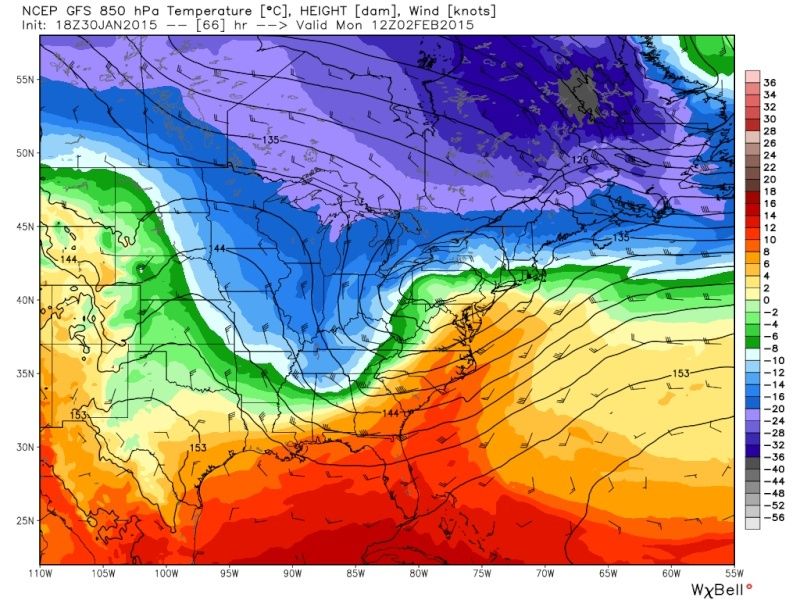
That said, I usually recall storm like this shifting south last minute. Key is not to over analyze this. We know what the upper air pattern looks like. Models should stay between the blue and green. We'll see tonight.
_________________
_______________________________________________________________________________________________________
CLICK HERE to view NJ Strong Snowstorm Classifications
Frank_Wx- Godzilla Seeker
- Posts : 21305
Reputation : 328
Join date : 2013-01-05
Age : 31
Location : Jersey City, NJ -
Page 10 of 17 • 1 ... 6 ... 9, 10, 11 ... 13 ... 17 ![]()
|
|
|