
 Search
Update #3: Final Snow/Ice Map, Fierce February Continues
Page 1 of 5 • 1, 2, 3, 4, 5 ![]()

Update #3: Final Snow/Ice Map, Fierce February Continues
![]() by Frank_Wx Sat Feb 07, 2015 7:19 pm
by Frank_Wx Sat Feb 07, 2015 7:19 pm
That's still showing 2-4 inches of snow for NYC, even though it may only accumulate on non road surfaces. At this point, there's no sense in changing my final call. I still think the lower ended of these ranges are attainable.
I'm sticking with this.

Last edited by Frank_Wx on Sun Feb 08, 2015 2:59 pm; edited 1 time in total
_________________
_______________________________________________________________________________________________________
CLICK HERE to view NJ Strong Snowstorm Classifications

Frank_Wx- Godzilla Seeker

- Posts : 21305
Reputation : 328
Join date : 2013-01-05
Age : 31
Location : Jersey City, NJ -

Re: Update #3: Final Snow/Ice Map, Fierce February Continues
![]() by jmanley32 Sat Feb 07, 2015 7:24 pm
by jmanley32 Sat Feb 07, 2015 7:24 pm

jmanley32- Senior Enthusiast

- Posts : 20516
Reputation : 108
Join date : 2013-12-12
Age : 42
Location : Yonkers, NY
Re: Update #3: Final Snow/Ice Map, Fierce February Continues
![]() by Frank_Wx Sat Feb 07, 2015 7:30 pm
by Frank_Wx Sat Feb 07, 2015 7:30 pm

_________________
_______________________________________________________________________________________________________
CLICK HERE to view NJ Strong Snowstorm Classifications
Frank_Wx- Godzilla Seeker
- Posts : 21305
Reputation : 328
Join date : 2013-01-05
Age : 31
Location : Jersey City, NJ -
Re: Update #3: Final Snow/Ice Map, Fierce February Continues
![]() by Grselig Sat Feb 07, 2015 7:32 pm
by Grselig Sat Feb 07, 2015 7:32 pm

Grselig- Senior Enthusiast
- Posts : 1408
Reputation : 140
Join date : 2013-03-04
Age : 54
Location : Wayne NJ
Re: Update #3: Final Snow/Ice Map, Fierce February Continues
![]() by Frank_Wx Sat Feb 07, 2015 7:36 pm
by Frank_Wx Sat Feb 07, 2015 7:36 pm
Just gotta take it easy...
_________________
_______________________________________________________________________________________________________
CLICK HERE to view NJ Strong Snowstorm Classifications
Frank_Wx- Godzilla Seeker
- Posts : 21305
Reputation : 328
Join date : 2013-01-05
Age : 31
Location : Jersey City, NJ -
Re: Update #3: Final Snow/Ice Map, Fierce February Continues
![]() by snow247 Sat Feb 07, 2015 7:45 pm
by snow247 Sat Feb 07, 2015 7:45 pm

snow247- Pro Enthusiast

- Posts : 2417
Reputation : 0
Join date : 2014-08-27
Location : Mount Ivy, NY - Elevation 545'
Re: Update #3: Final Snow/Ice Map, Fierce February Continues
![]() by rb924119 Sat Feb 07, 2015 7:51 pm
by rb924119 Sat Feb 07, 2015 7:51 pm
rb924119- Meteorologist

- Posts : 6890
Reputation : 194
Join date : 2013-02-06
Age : 32
Location : Greentown, Pa
Re: Update #3: Final Snow/Ice Map, Fierce February Continues
![]() by amugs Sat Feb 07, 2015 8:01 pm
by amugs Sat Feb 07, 2015 8:01 pm
_________________
Mugs
AKA:King: Snow Weenie
Self Proclaimed
WINTER 2014-15 : 55.12" +.02 for 6 coatings (avg. 35")
WINTER 2015-16 Total - 29.8" (Avg 35")
WINTER 2016-17 : 39.5" so far

amugs- Advanced Forecaster - Mod

- Posts : 15093
Reputation : 213
Join date : 2013-01-07
Age : 54
Location : Hillsdale,NJ
Re: Update #3: Final Snow/Ice Map, Fierce February Continues
![]() by Frank_Wx Sat Feb 07, 2015 8:03 pm
by Frank_Wx Sat Feb 07, 2015 8:03 pm
_________________
_______________________________________________________________________________________________________
CLICK HERE to view NJ Strong Snowstorm Classifications
Frank_Wx- Godzilla Seeker
- Posts : 21305
Reputation : 328
Join date : 2013-01-05
Age : 31
Location : Jersey City, NJ -
Re: Update #3: Final Snow/Ice Map, Fierce February Continues
![]() by Frank_Wx Sat Feb 07, 2015 8:04 pm
by Frank_Wx Sat Feb 07, 2015 8:04 pm
_________________
_______________________________________________________________________________________________________
CLICK HERE to view NJ Strong Snowstorm Classifications
Frank_Wx- Godzilla Seeker
- Posts : 21305
Reputation : 328
Join date : 2013-01-05
Age : 31
Location : Jersey City, NJ -
Re: Update #3: Final Snow/Ice Map, Fierce February Continues
![]() by NjWeatherGuy Sat Feb 07, 2015 8:24 pm
by NjWeatherGuy Sat Feb 07, 2015 8:24 pm

NjWeatherGuy- Advanced Forecaster

- Posts : 4100
Reputation : 28
Join date : 2013-01-06
Location : Belle Mead, NJ
Re: Update #3: Final Snow/Ice Map, Fierce February Continues
![]() by NjWeatherGuy Sat Feb 07, 2015 8:28 pm
by NjWeatherGuy Sat Feb 07, 2015 8:28 pm
NjWeatherGuy- Advanced Forecaster
- Posts : 4100
Reputation : 28
Join date : 2013-01-06
Location : Belle Mead, NJ
Re: Update #3: Final Snow/Ice Map, Fierce February Continues
![]() by jmanley32 Sat Feb 07, 2015 8:32 pm
by jmanley32 Sat Feb 07, 2015 8:32 pm
jmanley32- Senior Enthusiast
- Posts : 20516
Reputation : 108
Join date : 2013-12-12
Age : 42
Location : Yonkers, NY
Re: Update #3: Final Snow/Ice Map, Fierce February Continues
![]() by Yschiff Sat Feb 07, 2015 8:49 pm
by Yschiff Sat Feb 07, 2015 8:49 pm
Yschiff- Posts : 139
Reputation : 1
Join date : 2014-01-04
Location : Far Rockaway New York
Re: Update #3: Final Snow/Ice Map, Fierce February Continues
![]() by snow247 Sat Feb 07, 2015 8:53 pm
by snow247 Sat Feb 07, 2015 8:53 pm
Yschiff wrote:SREF?
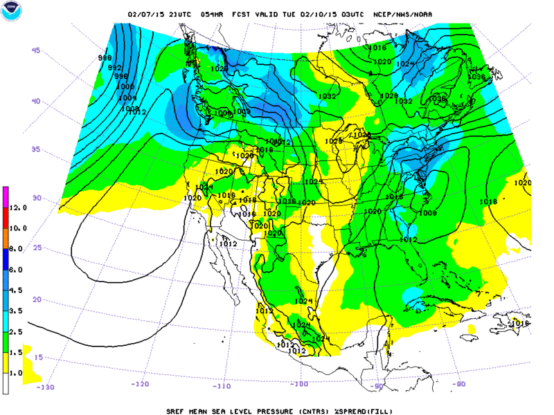
snow247- Pro Enthusiast
- Posts : 2417
Reputation : 0
Join date : 2014-08-27
Location : Mount Ivy, NY - Elevation 545'
Re: Update #3: Final Snow/Ice Map, Fierce February Continues
![]() by rb924119 Sat Feb 07, 2015 9:13 pm
by rb924119 Sat Feb 07, 2015 9:13 pm
rb924119- Meteorologist
- Posts : 6890
Reputation : 194
Join date : 2013-02-06
Age : 32
Location : Greentown, Pa
Re: Update #3: Final Snow/Ice Map, Fierce February Continues
![]() by rb924119 Sat Feb 07, 2015 9:14 pm
by rb924119 Sat Feb 07, 2015 9:14 pm
rb924119- Meteorologist
- Posts : 6890
Reputation : 194
Join date : 2013-02-06
Age : 32
Location : Greentown, Pa
Re: Update #3: Final Snow/Ice Map, Fierce February Continues
![]() by Frank_Wx Sat Feb 07, 2015 9:44 pm
by Frank_Wx Sat Feb 07, 2015 9:44 pm

_________________
_______________________________________________________________________________________________________
CLICK HERE to view NJ Strong Snowstorm Classifications
Frank_Wx- Godzilla Seeker
- Posts : 21305
Reputation : 328
Join date : 2013-01-05
Age : 31
Location : Jersey City, NJ -
Re: Update #3: Final Snow/Ice Map, Fierce February Continues
![]() by jmanley32 Sat Feb 07, 2015 9:49 pm
by jmanley32 Sat Feb 07, 2015 9:49 pm
jmanley32- Senior Enthusiast
- Posts : 20516
Reputation : 108
Join date : 2013-12-12
Age : 42
Location : Yonkers, NY
Re: Update #3: Final Snow/Ice Map, Fierce February Continues
![]() by snow247 Sat Feb 07, 2015 10:04 pm
by snow247 Sat Feb 07, 2015 10:04 pm
Didn't I say this last Saturday? lol
snow247- Pro Enthusiast
- Posts : 2417
Reputation : 0
Join date : 2014-08-27
Location : Mount Ivy, NY - Elevation 545'
Re: Update #3: Final Snow/Ice Map, Fierce February Continues
![]() by snow247 Sat Feb 07, 2015 10:17 pm
by snow247 Sat Feb 07, 2015 10:17 pm
snow247- Pro Enthusiast
- Posts : 2417
Reputation : 0
Join date : 2014-08-27
Location : Mount Ivy, NY - Elevation 545'
Re: Update #3: Final Snow/Ice Map, Fierce February Continues
![]() by rb924119 Sat Feb 07, 2015 10:23 pm
by rb924119 Sat Feb 07, 2015 10:23 pm
rb924119- Meteorologist
- Posts : 6890
Reputation : 194
Join date : 2013-02-06
Age : 32
Location : Greentown, Pa
Re: Update #3: Final Snow/Ice Map, Fierce February Continues
![]() by Frank_Wx Sat Feb 07, 2015 10:26 pm
by Frank_Wx Sat Feb 07, 2015 10:26 pm
_________________
_______________________________________________________________________________________________________
CLICK HERE to view NJ Strong Snowstorm Classifications
Frank_Wx- Godzilla Seeker
- Posts : 21305
Reputation : 328
Join date : 2013-01-05
Age : 31
Location : Jersey City, NJ -
Re: Update #3: Final Snow/Ice Map, Fierce February Continues
![]() by aiannone Sat Feb 07, 2015 10:27 pm
by aiannone Sat Feb 07, 2015 10:27 pm
rb924119 wrote:00z RGEM is a torch again lol Omg this is model mayhem at its finest.
do you have an image of total qpf?
_________________
-Alex Iannone-

aiannone- Senior Enthusiast - Mod
- Posts : 4813
Reputation : 92
Join date : 2013-01-07
Location : Saint James, LI (Northwest Suffolk Co.)
Re: Update #3: Final Snow/Ice Map, Fierce February Continues
![]() by rb924119 Sat Feb 07, 2015 10:35 pm
by rb924119 Sat Feb 07, 2015 10:35 pm
aiannone wrote:rb924119 wrote:00z RGEM is a torch again lol Omg this is model mayhem at its finest.
do you have an image of total qpf?
http://www.tropicaltidbits.com/analysis/models/rgem/2015020800/rgem_asnow_neus_16.png
http://www.tropicaltidbits.com/analysis/models/rgem/2015020800/rgem_apcpn_neus_16.png
Note that there is still more precipitation yet to fall after this, but the model does not go out any further in time.
rb924119- Meteorologist
- Posts : 6890
Reputation : 194
Join date : 2013-02-06
Age : 32
Location : Greentown, Pa
Page 1 of 5 • 1, 2, 3, 4, 5 ![]()
|
|
|