
 Search
Possible Snowstorm Thursday, 3/5
Page 6 of 29 •  1 ... 5, 6, 7 ... 17 ... 29
 ![]()
Re: Possible Snowstorm Thursday, 3/5
![]() by docstox12 Mon Mar 02, 2015 7:23 am
by docstox12 Mon Mar 02, 2015 7:23 am
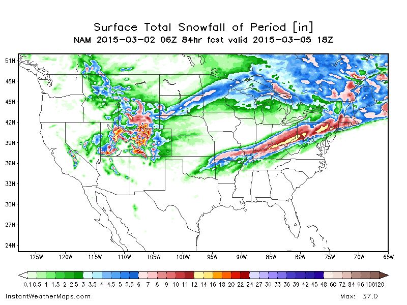
rb924119 wrote:Thanks Mugs!! Here is the 06z GFS Ensemble MEAN TOTAL SNOWFALL based on 10:
http://images1.earthsat.com/misc/mod-images/GFS/EN/06/snosums/0072/GFS_06_enUS_SF_0108.png
Pretty impressive for an ensemble mean....
Looks like S and E jackpots on this one.
docstox12- Wx Statistician Guru

- Posts : 8504
Join date : 2013-01-07
Re: Possible Snowstorm Thursday, 3/5
![]() by rb924119 Mon Mar 02, 2015 7:27 am
by rb924119 Mon Mar 02, 2015 7:27 am
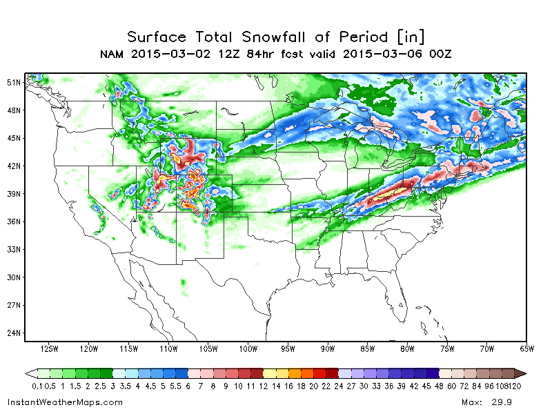
http://images1.earthsat.com/misc/mod-images/ECM/OP/00/snosums/0024/ECM_00_opUS_SF_0096.png
rb924119- Meteorologist

- Posts : 6890
Join date : 2013-02-06
Re: Possible Snowstorm Thursday, 3/5
![]() by rb924119 Mon Mar 02, 2015 7:29 am
by rb924119 Mon Mar 02, 2015 7:29 am
docstox12 wrote:rb924119 wrote:Thanks Mugs!! Here is the 06z GFS Ensemble MEAN TOTAL SNOWFALL based on 10:
http://images1.earthsat.com/misc/mod-images/GFS/EN/06/snosums/0072/GFS_06_enUS_SF_0108.png
Pretty impressive for an ensemble mean....
Looks like S and E jackpots on this one.
Doc, I wouldn't be too sure just yet. In my upcoming posts I'll explain...
rb924119- Meteorologist
- Posts : 6890
Reputation : 194
Join date : 2013-02-06
Age : 32
Location : Greentown, Pa
Re: Possible Snowstorm Thursday, 3/5
![]() by algae888 Mon Mar 02, 2015 7:33 am
by algae888 Mon Mar 02, 2015 7:33 am


algae888- Advanced Forecaster

- Posts : 5311
Reputation : 46
Join date : 2013-02-05
Age : 61
Location : mt. vernon, new york
Re: Possible Snowstorm Thursday, 3/5
![]() by docstox12 Mon Mar 02, 2015 7:37 am
by docstox12 Mon Mar 02, 2015 7:37 am
rb924119 wrote:docstox12 wrote:rb924119 wrote:Thanks Mugs!! Here is the 06z GFS Ensemble MEAN TOTAL SNOWFALL based on 10:
http://images1.earthsat.com/misc/mod-images/GFS/EN/06/snosums/0072/GFS_06_enUS_SF_0108.png
Pretty impressive for an ensemble mean....
Looks like S and E jackpots on this one.
Doc, I wouldn't be too sure just yet. In my upcoming posts I'll explain...
Would sure be a trend breaker, rb, if it wasn't!

docstox12- Wx Statistician Guru
- Posts : 8504
Reputation : 222
Join date : 2013-01-07
Age : 73
Location : Monroe NY
Re: Possible Snowstorm Thursday, 3/5
![]() by docstox12 Mon Mar 02, 2015 7:38 am
by docstox12 Mon Mar 02, 2015 7:38 am
algae888 wrote:good morning boys and girls. got a good laugh reading through the last few pages. wow what a week ahead no sleep for a few days. yes doc nws lowered temps for tues. night and wens just like mugs said and could have a serious ice threat by wens. morning. for thurs wow nam
I'm thinking 35-40 for Weds up here Al.
docstox12- Wx Statistician Guru
- Posts : 8504
Reputation : 222
Join date : 2013-01-07
Age : 73
Location : Monroe NY
Re: Possible Snowstorm Thursday, 3/5
![]() by algae888 Mon Mar 02, 2015 7:46 am
by algae888 Mon Mar 02, 2015 7:46 am
algae888- Advanced Forecaster
- Posts : 5311
Reputation : 46
Join date : 2013-02-05
Age : 61
Location : mt. vernon, new york
Re: Possible Snowstorm Thursday, 3/5
![]() by skinsfan1177 Mon Mar 02, 2015 7:50 am
by skinsfan1177 Mon Mar 02, 2015 7:50 am

skinsfan1177- Senior Enthusiast

- Posts : 4485
Reputation : 35
Join date : 2013-01-07
Age : 46
Location : Point Pleasant Boro
Re: Possible Snowstorm Thursday, 3/5
![]() by rb924119 Mon Mar 02, 2015 7:52 am
by rb924119 Mon Mar 02, 2015 7:52 am
Ok, so here is the 00z CMC/GEM Operational H5 map for 00z Thursday:
http://www.tropicaltidbits.com/analysis/models/gem/2015030200/gem_z500_vort_us_13.png
If you look back a couple pages, you will see that this is very close to a triple phase between the three key players. Anyway, that is not what I want you to focus on. Instead, focus on the 552 dam black contour line over the southwestern U.S. and notice how it slices through the Panhandle of Texas and northeastern New Mexico.
Here is the 00z CMC/GEM Ensemble H5 spaghetti plot for the same time:
http://images0.earthsat.com/misc/mod-images/CAN/EN/00/CAN_00_enUS_H50S_0072.png
Although there are some slight timing differences, which could also impact this event but I am not concerned with here, look at how many ensemble members either support the Operational OR actually show a deeper trough. This is a very good sign for this to trend north in coming runs. If it was more evenly split, then I'd be concerned, but to have roughly 70-80% of the ensemble members showing deeper H5 evolution (which likely means more interaction between the three waves) is key. This is not alone, though. The deeper solution also has strong support from both the NAM and the UKMET:
http://www.tropicaltidbits.com/analysis/models/nam/2015030200/nam_z500_vort_us_25.png
http://img.meteocentre.com/models/ukmet_amer_00/ukmet00_QQ500.11.gif?t=1425300098
As I mentioned there are also differences in timing, which as you can see the southern end of the main trough in the two posts immediately above is kicked east versus the CMC, but the depth is still there. Timing is very easy to change for the faster, especially with increasing baroclinicty of late-winter.
These three models (and respective ensembles) are also not alone. Take a look at the 12z and then 00z EURO Ensemble for the same time (Thursday 00z):
http://images0.earthsat.com/misc/mod-images/ECM/EN/12/ECM_12_enUS_H50S_0084.png
http://images0.earthsat.com/misc/mod-images/ECM/EN/00/ECM_00_enUS_H50S_0072.png
Even though the mean is relatively unchanged, look at how the southern members (which again is a majority of the ensemble) are clustered in the same region as the other models mentioned earlier. Also take notice how much sharper the trough became from 12z to last night's 00z. Again, this is a great sign because this is showing more interaction between the three systems.
Lastly, here is the 00z GFS Ensemble H5 spaghetti plot for Thursday 00z:
http://images0.earthsat.com/misc/mod-images/GFS/EN/00/GFS_00_enUS_H50S_0072.png
Look at how much of a northern outlier the Operational is to its own ensemble!!! It's in the weakest 15%....85% of its ensemble members are deeper than it, with 55% of the entire ensemble (so more than that with respect the members already south of the Operational) in exact agreement with all of the other models and ensemble spreads. Moral to the strory, I would start anticipating a northward jog with subsequent runs amongst the global suite, and to have a consensus near the NAM/UKMET solutions AS IT STANDS NOW. This could always change lol Those are my thoughts.
rb924119- Meteorologist
- Posts : 6890
Reputation : 194
Join date : 2013-02-06
Age : 32
Location : Greentown, Pa
Re: Possible Snowstorm Thursday, 3/5
![]() by rb924119 Mon Mar 02, 2015 7:57 am
by rb924119 Mon Mar 02, 2015 7:57 am
Dream on baby, dream on.....
rb924119- Meteorologist
- Posts : 6890
Reputation : 194
Join date : 2013-02-06
Age : 32
Location : Greentown, Pa
Re: Possible Snowstorm Thursday, 3/5
![]() by algae888 Mon Mar 02, 2015 8:09 am
by algae888 Mon Mar 02, 2015 8:09 am
rb nice. we are now inside 72hrs so looking more likely to happen than not. going off of model biases which someone mentioned a few pages back I think we'll see a solution between the nam (north) and gfs (south) which should put the majority of our area in the 6-12" range. wouldn't that be nice. big runs the next few days and how strong that low (tues,) gets and where boundary sets up is key. storms have been trending in our favor of late big change from earlier this year and of course last march.rb924119 wrote:Al, to complement your maps posted above:
Dream on baby, dream on.....
algae888- Advanced Forecaster
- Posts : 5311
Reputation : 46
Join date : 2013-02-05
Age : 61
Location : mt. vernon, new york
Re: Possible Snowstorm Thursday, 3/5
![]() by amugs Mon Mar 02, 2015 8:22 am
by amugs Mon Mar 02, 2015 8:22 am
Lets get through Tues into Wed first but I am chomping at the bit for the MECS/Godzilla potential Thursday. The Tues Storm will have an affect on Thurs as it has gone all winter long.
_________________
Mugs
AKA:King: Snow Weenie
Self Proclaimed
WINTER 2014-15 : 55.12" +.02 for 6 coatings (avg. 35")
WINTER 2015-16 Total - 29.8" (Avg 35")
WINTER 2016-17 : 39.5" so far

amugs- Advanced Forecaster - Mod

- Posts : 15093
Reputation : 213
Join date : 2013-01-07
Age : 54
Location : Hillsdale,NJ
Re: Possible Snowstorm Thursday, 3/5
![]() by Guest Mon Mar 02, 2015 8:24 am
by Guest Mon Mar 02, 2015 8:24 am
Guest- Guest
Re: Possible Snowstorm Thursday, 3/5
![]() by skinsfan1177 Mon Mar 02, 2015 8:27 am
by skinsfan1177 Mon Mar 02, 2015 8:27 am
skinsfan1177- Senior Enthusiast
- Posts : 4485
Reputation : 35
Join date : 2013-01-07
Age : 46
Location : Point Pleasant Boro
Re: Possible Snowstorm Thursday, 3/5
![]() by docstox12 Mon Mar 02, 2015 9:08 am
by docstox12 Mon Mar 02, 2015 9:08 am
skinsfan1177 wrote:Nam seems way north at this time
skins, I think it will be an average of the gfs and NAM.
docstox12- Wx Statistician Guru
- Posts : 8504
Reputation : 222
Join date : 2013-01-07
Age : 73
Location : Monroe NY
Re: Possible Snowstorm Thursday, 3/5
![]() by SNOW MAN Mon Mar 02, 2015 9:12 am
by SNOW MAN Mon Mar 02, 2015 9:12 am

SNOW MAN- Senior Enthusiast
- Posts : 1361
Reputation : 25
Join date : 2013-01-13
Age : 64
Location : Marshalls Creek Pa.
Re: Possible Snowstorm Thursday, 3/5
![]() by SNOW MAN Mon Mar 02, 2015 9:13 am
by SNOW MAN Mon Mar 02, 2015 9:13 am
SNOW MAN- Senior Enthusiast
- Posts : 1361
Reputation : 25
Join date : 2013-01-13
Age : 64
Location : Marshalls Creek Pa.
Re: Possible Snowstorm Thursday, 3/5
![]() by skinsfan1177 Mon Mar 02, 2015 9:14 am
by skinsfan1177 Mon Mar 02, 2015 9:14 am
docstox12 wrote:skinsfan1177 wrote:Nam seems way north at this time
skins, I think it will be an average of the gfs and NAM.
Got you doc but Nam is out of range at this point
skinsfan1177- Senior Enthusiast
- Posts : 4485
Reputation : 35
Join date : 2013-01-07
Age : 46
Location : Point Pleasant Boro
Re: Possible Snowstorm Thursday, 3/5
![]() by docstox12 Mon Mar 02, 2015 9:24 am
by docstox12 Mon Mar 02, 2015 9:24 am
SNOW MAN wrote:Local Mets are only calling for flurries and snow showers Thursday for my area. With the way things are going for my area I think they may be right. We only ended up with 2.4 inches from this last event.
SNOW, it hasn't been your winter, buddy.I'm more N and E of you so I have caught more snow from these weird storms.We need a big one a little W of the BM so we stay snow while S and E go slop/rain.Those are our jackpot storms.
docstox12- Wx Statistician Guru
- Posts : 8504
Reputation : 222
Join date : 2013-01-07
Age : 73
Location : Monroe NY
Re: Possible Snowstorm Thursday, 3/5
![]() by docstox12 Mon Mar 02, 2015 9:26 am
by docstox12 Mon Mar 02, 2015 9:26 am
skinsfan1177 wrote:docstox12 wrote:skinsfan1177 wrote:Nam seems way north at this time
skins, I think it will be an average of the gfs and NAM.
Got you doc but Nam is out of range at this point
Skins, anyway, you have to pretty much go nowcast on these storms this winter, models have been bizarre.
docstox12- Wx Statistician Guru
- Posts : 8504
Reputation : 222
Join date : 2013-01-07
Age : 73
Location : Monroe NY
Re: Possible Snowstorm Thursday, 3/5
![]() by rb924119 Mon Mar 02, 2015 9:54 am
by rb924119 Mon Mar 02, 2015 9:54 am
Not as juicy, but still fun
rb924119- Meteorologist
- Posts : 6890
Reputation : 194
Join date : 2013-02-06
Age : 32
Location : Greentown, Pa
Re: Possible Snowstorm Thursday, 3/5
![]() by rb924119 Mon Mar 02, 2015 9:55 am
by rb924119 Mon Mar 02, 2015 9:55 am
syosnow94 wrote:rb924119!! Your operational maps with the colors and the white mean included are one of the best, most informative easy to understand things I've seen on this sight. Thank you!! You have contributed a lot to the forum. You and Frank both only in your early 20's teaching us is amazing. You deserve a foot plus IYBY from this next one.
Thanks, Syo
rb924119- Meteorologist
- Posts : 6890
Reputation : 194
Join date : 2013-02-06
Age : 32
Location : Greentown, Pa
Re: Possible Snowstorm Thursday, 3/5
![]() by Frank_Wx Mon Mar 02, 2015 9:57 am
by Frank_Wx Mon Mar 02, 2015 9:57 am

_________________
_______________________________________________________________________________________________________
CLICK HERE to view NJ Strong Snowstorm Classifications

Frank_Wx- Godzilla Seeker

- Posts : 21305
Reputation : 328
Join date : 2013-01-05
Age : 31
Location : Jersey City, NJ -


algae888- Advanced Forecaster
- Posts : 5311
Reputation : 46
Join date : 2013-02-05
Age : 61
Location : mt. vernon, new york
Re: Possible Snowstorm Thursday, 3/5
![]() by Frank_Wx Mon Mar 02, 2015 9:58 am
by Frank_Wx Mon Mar 02, 2015 9:58 am
Some full run SREF plumes for fun:
EWR - 5.76" - one member 18.56"
BLM - 6.53" - one member 20.49"
LGA - Similar to EWR
JFK - 6.15" - one member 18.29"
HPN - 5.53" - one member 17.64"
PHL - 7.45 - one member 23.16"
_________________
_______________________________________________________________________________________________________
CLICK HERE to view NJ Strong Snowstorm Classifications
Frank_Wx- Godzilla Seeker
- Posts : 21305
Reputation : 328
Join date : 2013-01-05
Age : 31
Location : Jersey City, NJ -
Re: Possible Snowstorm Thursday, 3/5
![]() by rb924119 Mon Mar 02, 2015 10:04 am
by rb924119 Mon Mar 02, 2015 10:04 am
http://wxcaster.com/gis-snow-overlays.php3?STATIONID=BGM
rb924119- Meteorologist
- Posts : 6890
Reputation : 194
Join date : 2013-02-06
Age : 32
Location : Greentown, Pa
Re: Possible Snowstorm Thursday, 3/5
![]() by Frank_Wx Mon Mar 02, 2015 10:20 am
by Frank_Wx Mon Mar 02, 2015 10:20 am
_________________
_______________________________________________________________________________________________________
CLICK HERE to view NJ Strong Snowstorm Classifications
Frank_Wx- Godzilla Seeker
- Posts : 21305
Reputation : 328
Join date : 2013-01-05
Age : 31
Location : Jersey City, NJ -
Page 6 of 29 • 1 ... 5, 6, 7 ... 17 ... 29 ![]()
|
|
|