
 Search
Long Range Thread 8.0
Page 22 of 40 •  1 ... 12 ... 21, 22, 23 ... 31 ... 40
 ![]()
Re: Long Range Thread 8.0
![]() by jmanley32 Tue Oct 13, 2015 4:27 pm
by jmanley32 Tue Oct 13, 2015 4:27 pm
jmanley32- Senior Enthusiast

- Posts : 20513
Join date : 2013-12-12
Re: Long Range Thread 8.0
![]() by jimv45 Tue Oct 13, 2015 4:37 pm
by jimv45 Tue Oct 13, 2015 4:37 pm
jimv45- Senior Enthusiast
- Posts : 1168
Join date : 2013-09-20
Re: Long Range Thread 8.0
![]() by skinsfan1177 Tue Oct 13, 2015 4:58 pm
by skinsfan1177 Tue Oct 13, 2015 4:58 pm
jimv45 wrote:Been hearing that this winter looks promising for non snow lovers why is everyone so excited about this winter that these so called experts say otherwise? But I trust this site so hope is there.
Honestly jimv I have heard both sides so at this point who knows actually I hear more of a positive for snow lovers. And from what the guys and gals on here are saying things are trending in the right direction for the snow lovers. But I remain optimistic it's still early

skinsfan1177- Senior Enthusiast
- Posts : 4485
Reputation : 35
Join date : 2013-01-07
Age : 46
Location : Point Pleasant Boro
Re: Long Range Thread 8.0
![]() by jimv45 Tue Oct 13, 2015 5:05 pm
by jimv45 Tue Oct 13, 2015 5:05 pm
jimv45- Senior Enthusiast
- Posts : 1168
Reputation : 36
Join date : 2013-09-20
Location : Hopewell jct.
Re: Long Range Thread 8.0
![]() by NjWeatherGuy Wed Oct 14, 2015 12:36 am
by NjWeatherGuy Wed Oct 14, 2015 12:36 am

NjWeatherGuy- Advanced Forecaster

- Posts : 4100
Reputation : 28
Join date : 2013-01-06
Location : Belle Mead, NJ
Re: Long Range Thread 8.0
![]() by sroc4 Wed Oct 14, 2015 7:08 am
by sroc4 Wed Oct 14, 2015 7:08 am
NjWeatherGuy wrote:I feel like the ones we always expect to be cold and snowy bust unfortunately, wasnt last year somewhat of a surprise? Remember its an El Nino which can go two ways, if it stays very strong it could be a 1997 redux which was crummy snow wise, however it is forecast to weaken, if it goes out of strong territory it could resemble 2009-2010 which was a good snowy pattern.
Last year was a surprise to some, but not to many. I was surprised by just how much above normal snowfall fell for my area, but in no way was I surprised by the above normal snow and the cold temps. This time of year I think the danger in overanalyzing the daily or even weekly details of the major drivers that set us up for Jan, Feb, and March is that you begin to miss the big picture. The major drivers, ENSO, +PDO, AO for example, IMHO are setting us up again for above normal snowfall. Will it actually happen? Ill tell you in May. There are still wild cards etc but only time will iron out some of the details. But just like last winter I get this feeling that I am going to need to constantly be pulling people back off the ledge. Just because the 10-14day forecast is showing a ridge in the east and a trough in the west people are starting to panic. Im not saying you Tom, but people in general on multiple sites. We all should take a little break in the daily forecasting of the Jan-March time frame and let a month or so go by, then digest the information as a whole.
I had a feeling that the cooler than normal temps that we are going to see this weekend was going to be more transient. IMO this is because of climatology meaning the time of year. There still is not a huge snow pack up in Canada, so this time of year when a deep trough tries to dig into the east the cold air can and does modify(relatively speaking) the further south in Lat it gets. This modification does not give it a lot of "staying power". If this same pattern shows up in Dec and Jan there will be a much higher tendency for the colder air to eventually lock in for late Jan Feb and March similar to last year. I know there is more to it than that, but I hope you all get my idea.
Look at this: Last nights Euro ensemble mean at 500mb for the 10 day(Oct24th) and the 15day(Oct29th). Both look like they have a warm ridge centered over the east coast with a trough in the west. Not good for cold lovers. Lets see what 500mb looks like in 5 days, 10days, and 15days from now.
 " />
" /> " />
" />Just going to throw this out there too. Those lower heights(blue colors) you see on the 10day down near the Bahamas may be the EPS hinting at some tropical funny business 10-14days from now.
_________________
"In weather and in life, there's no winning and losing; there's only winning and learning."
WINTER 2012/2013 TOTALS 43.65"WINTER 2017/2018 TOTALS 62.85" WINTER 2022/2023 TOTALS 4.9"
WINTER 2013/2014 TOTALS 64.85"WINTER 2018/2019 TOTALS 14.25" WINTER 2023/2024 TOTALS 13.1"
WINTER 2014/2015 TOTALS 71.20"WINTER 2019/2020 TOTALS 6.35"
WINTER 2015/2016 TOTALS 35.00"WINTER 2020/2021 TOTALS 37.75"
WINTER 2016/2017 TOTALS 42.25"WINTER 2021/2022 TOTALS 31.65"

sroc4- Admin

- Posts : 8331
Reputation : 301
Join date : 2013-01-07
Location : Wading River, LI
Re: Long Range Thread 8.0
![]() by Frank_Wx Wed Oct 14, 2015 8:11 am
by Frank_Wx Wed Oct 14, 2015 8:11 am
rb924119 wrote:Just thought I'd post this here for those interested:
https://drive.google.com/file/d/0Byod2Sk27yNYclZMUmQ5dmtIUXc/view?usp=sharing
This is not my work, but that of Joe Bastardi who works for WeatherBell. It's short, sweet, and adds even more hope for this upcoming season. I personally hold the UKMET as one of my favorite models, but am unfamiliar with its longer range prediction performance. That said, whispers from a guy that I work with were along the lines of that it's usually pretty decent. Again, I can't say one way or the other. Interesting none the less....
As long as region 3.4 is the warmest of the other ENSO regions, I feel we'll be fair game to have a decent winter. Like Joe B said, this will ensure the axis of the ridge is further west which better angles the trough / STJ over the east. Right now, the eastern regions continue being warmer but there's a trend that I am seeing and liking.
jimv45 wrote:Been hearing that this winter looks promising for non snow lovers why is everyone so excited about this winter that these so called experts say otherwise? But I trust this site so hope is there.
It's hard to say, Jim. There is still a lot of information we need to uncover first before proclaiming a good or bad winter is upon us. Still too early. Once my winter forecast comes out I hope I'll have solid information by then.
NjWeatherGuy wrote:I feel like the ones we always expect to be cold and snowy bust unfortunately, wasnt last year somewhat of a surprise? Remember its an El Nino which can go two ways, if it stays very strong it could be a 1997 redux which was crummy snow wise, however it is forecast to weaken, if it goes out of strong territory it could resemble 2009-2010 which was a good snowy pattern.
Exactly. El Nino could really benefit us or just be a disaster. This season is going to be tough to predict.
_________________
_______________________________________________________________________________________________________
CLICK HERE to view NJ Strong Snowstorm Classifications

Frank_Wx- Godzilla Seeker
- Posts : 21305
Reputation : 328
Join date : 2013-01-05
Age : 31
Location : Jersey City, NJ -

Re: Long Range Thread 8.0
![]() by Frank_Wx Wed Oct 14, 2015 8:16 am
by Frank_Wx Wed Oct 14, 2015 8:16 am
sroc4 wrote:NjWeatherGuy wrote:I feel like the ones we always expect to be cold and snowy bust unfortunately, wasnt last year somewhat of a surprise? Remember its an El Nino which can go two ways, if it stays very strong it could be a 1997 redux which was crummy snow wise, however it is forecast to weaken, if it goes out of strong territory it could resemble 2009-2010 which was a good snowy pattern.
Last year was a surprise to some, but not to many. I was surprised by just how much above normal snowfall fell for my area, but in no way was I surprised by the above normal snow and the cold temps. This time of year I think the danger in overanalyzing the daily or even weekly details of the major drivers that set us up for Jan, Feb, and March is that you begin to miss the big picture. The major drivers, ENSO, +PDO, AO for example, IMHO are setting us up again for above normal snowfall. Will it actually happen? Ill tell you in May. There are still wild cards etc but only time will iron out some of the details. But just like last winter I get this feeling that I am going to need to constantly be pulling people back off the ledge. Just because the 10-14day forecast is showing a ridge in the east and a trough in the west people are starting to panic. Im not saying you Tom, but people in general on multiple sites. We all should take a little break in the daily forecasting of the Jan-March time frame and let a month or so go by, then digest the information as a whole.
I had a feeling that the cooler than normal temps that we are going to see this weekend was going to be more transient. IMO this is because of climatology meaning the time of year. There still is not a huge snow pack up in Canada, so this time of year when a deep trough tries to dig into the east the cold air can and does modify(relatively speaking) the further south in Lat it gets. This modification does not give it a lot of "staying power". If this same pattern shows up in Dec and Jan there will be a much higher tendency for the colder air to eventually lock in for late Jan Feb and March similar to last year. I know there is more to it than that, but I hope you all get my idea.
Look at this: Last nights Euro ensemble mean at 500mb for the 10 day(Oct24th) and the 15day(Oct29th). Both look like they have a warm ridge centered over the east coast with a trough in the west. Not good for cold lovers. Lets see what 500mb looks like in 5 days, 10days, and 15days from now.
Just going to throw this out there too. Those lower heights(blue colors) you see on the 10day down near the Bahamas may be the EPS hinting at some tropical funny business 10-14days from now.
Yea, it's pretty clear the cold spell this week and weekend is transient. Normal to above normal weather will return next week.

The Aleutian trough has retrograded back into Asia and the NAO is positive. This allows the SE Ridge to flex its muscles.
_________________
_______________________________________________________________________________________________________
CLICK HERE to view NJ Strong Snowstorm Classifications
Frank_Wx- Godzilla Seeker
- Posts : 21305
Reputation : 328
Join date : 2013-01-05
Age : 31
Location : Jersey City, NJ -
Re: Long Range Thread 8.0
![]() by sroc4 Wed Oct 14, 2015 9:10 am
by sroc4 Wed Oct 14, 2015 9:10 am
Frank_Wx wrote:sroc4 wrote:NjWeatherGuy wrote:I feel like the ones we always expect to be cold and snowy bust unfortunately, wasnt last year somewhat of a surprise? Remember its an El Nino which can go two ways, if it stays very strong it could be a 1997 redux which was crummy snow wise, however it is forecast to weaken, if it goes out of strong territory it could resemble 2009-2010 which was a good snowy pattern.
Last year was a surprise to some, but not to many. I was surprised by just how much above normal snowfall fell for my area, but in no way was I surprised by the above normal snow and the cold temps. This time of year I think the danger in overanalyzing the daily or even weekly details of the major drivers that set us up for Jan, Feb, and March is that you begin to miss the big picture. The major drivers, ENSO, +PDO, AO for example, IMHO are setting us up again for above normal snowfall. Will it actually happen? Ill tell you in May. There are still wild cards etc but only time will iron out some of the details. But just like last winter I get this feeling that I am going to need to constantly be pulling people back off the ledge. Just because the 10-14day forecast is showing a ridge in the east and a trough in the west people are starting to panic. Im not saying you Tom, but people in general on multiple sites. We all should take a little break in the daily forecasting of the Jan-March time frame and let a month or so go by, then digest the information as a whole.
I had a feeling that the cooler than normal temps that we are going to see this weekend was going to be more transient. IMO this is because of climatology meaning the time of year. There still is not a huge snow pack up in Canada, so this time of year when a deep trough tries to dig into the east the cold air can and does modify(relatively speaking) the further south in Lat it gets. This modification does not give it a lot of "staying power". If this same pattern shows up in Dec and Jan there will be a much higher tendency for the colder air to eventually lock in for late Jan Feb and March similar to last year. I know there is more to it than that, but I hope you all get my idea.
Look at this: Last nights Euro ensemble mean at 500mb for the 10 day(Oct24th) and the 15day(Oct29th). Both look like they have a warm ridge centered over the east coast with a trough in the west. Not good for cold lovers. Lets see what 500mb looks like in 5 days, 10days, and 15days from now.
Just going to throw this out there too. Those lower heights(blue colors) you see on the 10day down near the Bahamas may be the EPS hinting at some tropical funny business 10-14days from now.
Yea, it's pretty clear the cold spell this week and weekend is transient. Normal to above normal weather will return next week.
The Aleutian trough has retrograded back into Asia and the NAO is positive. This allows the SE Ridge to flex its muscles.
Hey Frank to expand on this a little, warmth into the east in the 10-14day shouldn't come as any surprise given the time of year and some of the players on the field. Frank I know you know this but for others it has been said many times this year and certainly in past years that some of the same drivers in Sept October November will lead to entirely different outcomes in say Dec, Jan, Feb . For example:
Here is the MJO forecast for the next 2 weeks for both the GFS and the Euro. Both have a strong pulse out into Phase 1 of the MJO over the next 10-14days. (For a review on what the MJO is click here: https://www.njstrongweatherforum.com/t511-what-is-the-mjo-really)
 " />
" /> " />
" />Now you may have heard in the past that phase 1 of the MJO typically leads to cold and increased stormy chances in the east right? Well lets look at the climatology...aka the time of year.
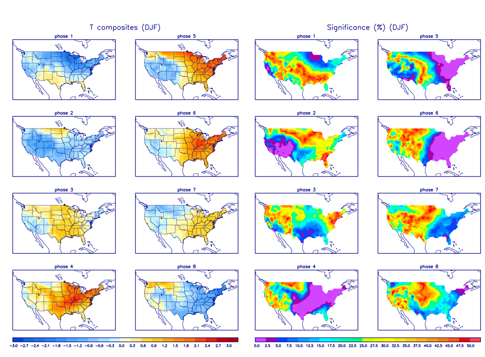
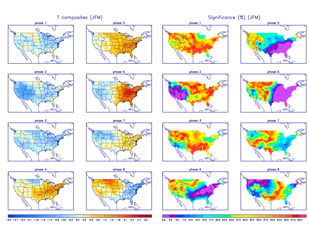
The next image is how the temperature anomalies look across the country in Dec, Jan, and Feb(DJF) depending on what phase the MJO is in. Blue colors indicate colder than normal, and oranges indicate warmer than normal. BTW just because the MJO is in a particular phase it doesn't absolutely have to behave like these next maps indicate. The stronger the pulse, aka the further away from the center (AKA Circle Of Death COD) the more likely it will become a stronger player in driving the overall pattern, but recall the pattern as a whole is always the sum of all parts (phases of the MJO, ENSO, AO, PNA, EPO, PDO, NAO, etc. you get the point).
So again here is what the temperature anomalies typically look like when the MJO enters any given phase for DJF. Take particular notice to Phase 1 which we are about to go into top left. Cold right?? So what gives?
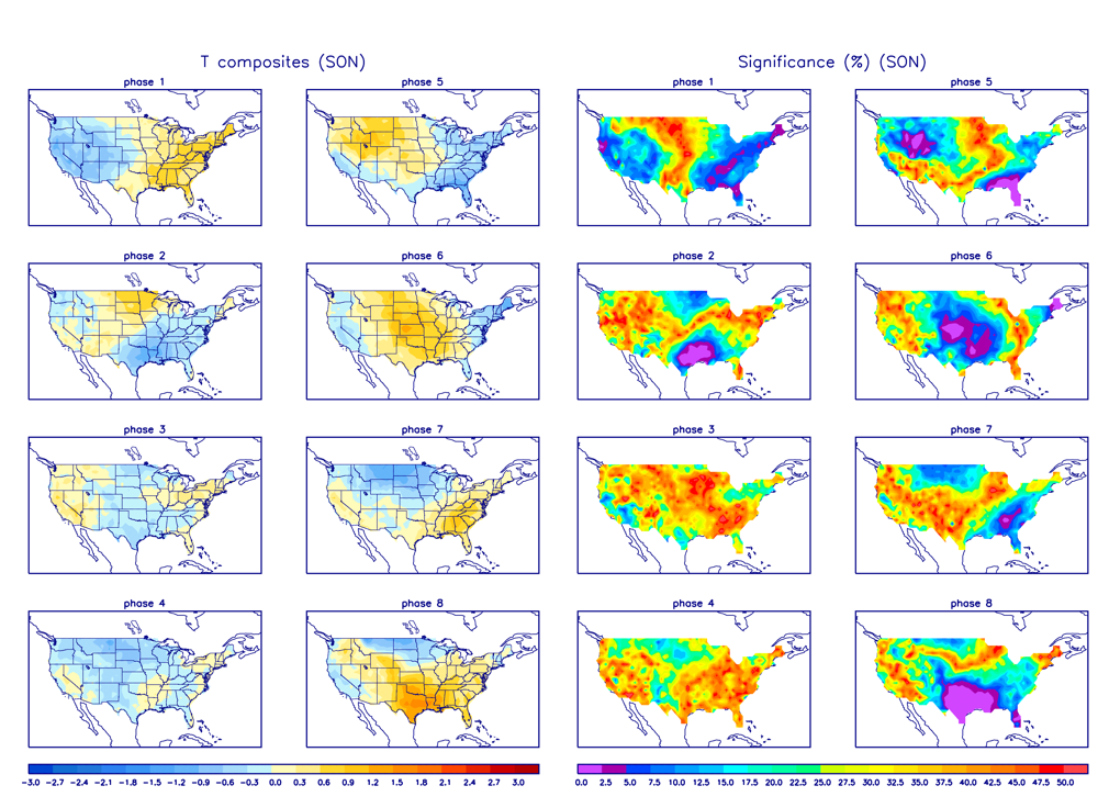
Now look at how the different MJO phases behaves during Sept, Oct, Nov(SON) again paying particular attention to phase 1 in the top left corner. Completely opposite of what DJF looks like.
Now look at the EPS 850mb temperature anomalies in the long range. Looks a lot like the map above for phase 1, warm anomalies in the east; cooler in the west.
 " />
" />This is all due to climatology or the time of year. Remember the deeper into the season we get the greater the differences in temperatures we get between the northern latitudes, and southern latitudes. This temp gradient drives the strength of the various jet streams; therefore, the same pulse of convection in the phase 1 region in different times of year leads to different outcomes down stream because other atmospheric influences are different.
Now one last thought is that all of the above is also 10-14days out so trending in different directions is still likely, but you can see how the EPS at he moment has some sound backing in the drivers leading to warm temp anomalies in the east towards the end of the month. But the way I see it we are right on schedule for the winter thus far.

You can see below that the Jan, Feb, March(JFM) MJO temp anomalies are similar to DJF
_________________
"In weather and in life, there's no winning and losing; there's only winning and learning."
WINTER 2012/2013 TOTALS 43.65"WINTER 2017/2018 TOTALS 62.85" WINTER 2022/2023 TOTALS 4.9"
WINTER 2013/2014 TOTALS 64.85"WINTER 2018/2019 TOTALS 14.25" WINTER 2023/2024 TOTALS 13.1"
WINTER 2014/2015 TOTALS 71.20"WINTER 2019/2020 TOTALS 6.35"
WINTER 2015/2016 TOTALS 35.00"WINTER 2020/2021 TOTALS 37.75"
WINTER 2016/2017 TOTALS 42.25"WINTER 2021/2022 TOTALS 31.65"
sroc4- Admin
- Posts : 8331
Reputation : 301
Join date : 2013-01-07
Location : Wading River, LI
Re: Long Range Thread 8.0
![]() by amugs Wed Oct 14, 2015 9:25 am
by amugs Wed Oct 14, 2015 9:25 am
One man's view
97-98 redux is not going to happen IMHO due to the data that is out - a basin wide event not just an EPAC event for one and a HUGE reason at this. The other aspects that I feel are uncharted waters (no pun intended) is the large warm body of water off the California coast and Baja region as well as the region just south of the Aleutian Islands. The Cali waters I feel with help pump the STJ and the Aleutian Low will help set up the pattern fro our cross polar flow. I have looked for and so have many others analogs for such as described above and none can be found. WE have never had such a set up in pacific before that we are seeing. Each Nino event is unlike the last granted but the basin wide "Modaki" event is within realm at this point. The waters of the coast of SA are cooling even though they are still warm but the waters in regions 3, 3.4 and 4 are warmer anomalous wise. Region 4 is of the charts for a nino event. Also, the depth of the warm waters in regions 3.4 and 4 are deep which would leave one to believe that this body would take some time to cool rather than 1.2 which is a shallower depth just by plain physics and we will see it cool and faster than 3.4 and 4 in the coming weeks.
BASIN WIDE EVENT as per this chart:(posted above as well)

Here is 1997:
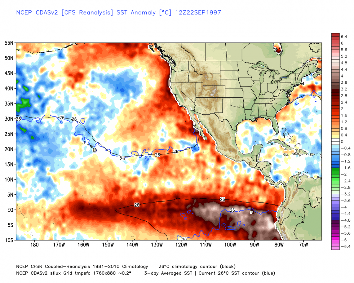
Here is ours presently

Do you see what I am talking about with the red and brown waters.
More info to show Frank point above about the cooling and liking trend:
DATE 1.2 3 3.4 4
20MAY2015 26.6 2.6 28.2 1.2 28.9 1.1 29.8 1.1
27MAY2015 26.3 2.6 28.2 1.4 29.0 1.3 29.9 1.1
03JUN2015 25.3 1.9 28.1 1.4 29.0 1.2 30.0 1.2
10JUN2015 25.7 2.6 28.1 1.5 29.0 1.3 29.9 1.1
17JUN2015 25.4 2.7 28.2 1.8 29.0 1.4 29.9 1.1
24JUN2015 25.1 2.6 28.1 1.9 28.9 1.4 29.9 1.1
01JUL2015 24.9 2.7 28.0 2.0 28.9 1.4 29.8 1.0
08JUL2015 25.2 3.3 27.9 2.1 28.8 1.5 29.9 1.1
15JUL2015 24.6 2.9 27.9 2.3 28.9 1.7 29.8 1.0
22JUL2015 23.7 2.3 27.6 2.1 28.8 1.6 29.8 1.0
29JUL2015 23.9 2.7 27.4 2.1 28.8 1.7 29.7 1.0
05AUG2015 23.6 2.6 27.6 2.3 28.9 1.9 29.6 0.9
12AUG2015 22.8 2.0 27.3 2.2 28.9 2.0 29.6 0.9
19AUG2015 22.4 1.7 27.2 2.2 28.9 2.1 29.7 1.1
26AUG2015 22.6 2.0 27.3 2.3 29.0 2.2 29.7 1.1
02SEP2015 22.7 2.2 27.3 2.4 28.9 2.1 29.7 1.0
09SEP2015 22.5 2.0 27.4 2.6 29.0 2.3 29.7 1.0
16SEP2015 23.0 2.6 27.6 2.7 29.0 2.3 29.8 1.1
23SEP2015 23.2 2.7 27.5 2.6 29.0 2.3 29.8 1.1
30SEP2015 23.4 2.8 27.6 2.8 29.1 2.4 29.7 1.1
07OCT2015 23.4 2.7 27.7 2.8 29.1 2.4 29.7 1.0
region 1.2 cooling, 3.4 and 4 holding ground temps wise - data says trop forcing out by dateline.
Can El Nino override things and make this wet and moderate winter, yes but if it was east based concentrated in just region 1.2 and 3 as in 1997 certainly but this is becoming and is a basin wide nino with the forcing from this setting up more west than east region 3, 3.4 and 4.
Hey, two things are going to happen - one we have a good to great winter (DJFM I am not punting December just yet still have time to go before this happens), two I am totally wrong and I get my but chewed out by many snow weenies - board, friends, families.
_________________
Mugs
AKA:King: Snow Weenie
Self Proclaimed
WINTER 2014-15 : 55.12" +.02 for 6 coatings (avg. 35")
WINTER 2015-16 Total - 29.8" (Avg 35")
WINTER 2016-17 : 39.5" so far

amugs- Advanced Forecaster - Mod

- Posts : 15093
Reputation : 213
Join date : 2013-01-07
Age : 54
Location : Hillsdale,NJ
Re: Long Range Thread 8.0
![]() by skinsfan1177 Wed Oct 14, 2015 6:16 pm
by skinsfan1177 Wed Oct 14, 2015 6:16 pm
skinsfan1177- Senior Enthusiast
- Posts : 4485
Reputation : 35
Join date : 2013-01-07
Age : 46
Location : Point Pleasant Boro
Re: Long Range Thread 8.0
![]() by sroc4 Wed Oct 14, 2015 7:13 pm
by sroc4 Wed Oct 14, 2015 7:13 pm
_________________
"In weather and in life, there's no winning and losing; there's only winning and learning."
WINTER 2012/2013 TOTALS 43.65"WINTER 2017/2018 TOTALS 62.85" WINTER 2022/2023 TOTALS 4.9"
WINTER 2013/2014 TOTALS 64.85"WINTER 2018/2019 TOTALS 14.25" WINTER 2023/2024 TOTALS 13.1"
WINTER 2014/2015 TOTALS 71.20"WINTER 2019/2020 TOTALS 6.35"
WINTER 2015/2016 TOTALS 35.00"WINTER 2020/2021 TOTALS 37.75"
WINTER 2016/2017 TOTALS 42.25"WINTER 2021/2022 TOTALS 31.65"
sroc4- Admin
- Posts : 8331
Reputation : 301
Join date : 2013-01-07
Location : Wading River, LI
Re: Long Range Thread 8.0
![]() by NjWeatherGuy Wed Oct 14, 2015 10:02 pm
by NjWeatherGuy Wed Oct 14, 2015 10:02 pm
NjWeatherGuy- Advanced Forecaster
- Posts : 4100
Reputation : 28
Join date : 2013-01-06
Location : Belle Mead, NJ
Re: Long Range Thread 8.0
![]() by Frank_Wx Wed Oct 14, 2015 10:35 pm
by Frank_Wx Wed Oct 14, 2015 10:35 pm
skinsfan1177 wrote:Not sure if anyone has looked at models this afternoon Gfs showing blocking again where Euro says no. Can anyone elaborate on this.
The GEFS don't indicate there will be blocking in the long range.
_________________
_______________________________________________________________________________________________________
CLICK HERE to view NJ Strong Snowstorm Classifications
Frank_Wx- Godzilla Seeker
- Posts : 21305
Reputation : 328
Join date : 2013-01-05
Age : 31
Location : Jersey City, NJ -
Re: Long Range Thread 8.0
![]() by Snow88 Thu Oct 15, 2015 12:20 am
by Snow88 Thu Oct 15, 2015 12:20 am

Snow88- Senior Enthusiast
- Posts : 2193
Reputation : 4
Join date : 2013-01-09
Age : 35
Location : Brooklyn, NY
Re: Long Range Thread 8.0
![]() by amugs Thu Oct 15, 2015 7:58 am
by amugs Thu Oct 15, 2015 7:58 am


_________________
Mugs
AKA:King: Snow Weenie
Self Proclaimed
WINTER 2014-15 : 55.12" +.02 for 6 coatings (avg. 35")
WINTER 2015-16 Total - 29.8" (Avg 35")
WINTER 2016-17 : 39.5" so far
amugs- Advanced Forecaster - Mod
- Posts : 15093
Reputation : 213
Join date : 2013-01-07
Age : 54
Location : Hillsdale,NJ
Re: Long Range Thread 8.0
![]() by amugs Thu Oct 15, 2015 9:47 am
by amugs Thu Oct 15, 2015 9:47 am
JAMSTEC is also out today w/ essentially the same look as its previous run. Near normal temperatures running along the Mason-Dixon line with cool to the south and warm to the north. What's interesting to me is the cool anomalies are fairly far north in the Plains, suggesting that it's more than STJ induced cold. It's difficult to determine w/o H5, but the implication seems to be for a west based -NAO and -EPO/+PNA based upon temperatures. The UK is cold which would imply a -NAO forecasted


_________________
Mugs
AKA:King: Snow Weenie
Self Proclaimed
WINTER 2014-15 : 55.12" +.02 for 6 coatings (avg. 35")
WINTER 2015-16 Total - 29.8" (Avg 35")
WINTER 2016-17 : 39.5" so far
amugs- Advanced Forecaster - Mod
- Posts : 15093
Reputation : 213
Join date : 2013-01-07
Age : 54
Location : Hillsdale,NJ
Re: Long Range Thread 8.0
![]() by amugs Thu Oct 15, 2015 9:52 am
by amugs Thu Oct 15, 2015 9:52 am

2009

2002

Where does one sign for such???
This is due (I am taking an eggumacated guess here as the bros in Pa-terson would say!) due the forcing being out at the Dateline - very good news IMHO.
_________________
Mugs
AKA:King: Snow Weenie
Self Proclaimed
WINTER 2014-15 : 55.12" +.02 for 6 coatings (avg. 35")
WINTER 2015-16 Total - 29.8" (Avg 35")
WINTER 2016-17 : 39.5" so far
amugs- Advanced Forecaster - Mod
- Posts : 15093
Reputation : 213
Join date : 2013-01-07
Age : 54
Location : Hillsdale,NJ
Re: Long Range Thread 8.0
![]() by amugs Thu Oct 15, 2015 1:43 pm
by amugs Thu Oct 15, 2015 1:43 pm
2014-15

2013-14
 \
\So we kind of take it with a grain of salt but look at the pattern set up which looks good overall.
_________________
Mugs
AKA:King: Snow Weenie
Self Proclaimed
WINTER 2014-15 : 55.12" +.02 for 6 coatings (avg. 35")
WINTER 2015-16 Total - 29.8" (Avg 35")
WINTER 2016-17 : 39.5" so far
amugs- Advanced Forecaster - Mod
- Posts : 15093
Reputation : 213
Join date : 2013-01-07
Age : 54
Location : Hillsdale,NJ
Re: Long Range Thread 8.0
![]() by amugs Thu Oct 15, 2015 2:54 pm
by amugs Thu Oct 15, 2015 2:54 pm
_________________
Mugs
AKA:King: Snow Weenie
Self Proclaimed
WINTER 2014-15 : 55.12" +.02 for 6 coatings (avg. 35")
WINTER 2015-16 Total - 29.8" (Avg 35")
WINTER 2016-17 : 39.5" so far
amugs- Advanced Forecaster - Mod
- Posts : 15093
Reputation : 213
Join date : 2013-01-07
Age : 54
Location : Hillsdale,NJ
Re: Long Range Thread 8.0
![]() by Guest Thu Oct 15, 2015 3:41 pm
by Guest Thu Oct 15, 2015 3:41 pm
Guest- Guest
Re: Long Range Thread 8.0
![]() by Dunnzoo Thu Oct 15, 2015 4:12 pm
by Dunnzoo Thu Oct 15, 2015 4:12 pm
syosnow94 wrote:Just heard on WCBS 880 a.m. at 3:00 p.m. that this winter will be much milder and wetter for the tri-state area with way less snow than last year. It was one of their headline stories at 3.
Looks like they are taking NOAA's forecast

_________________
Janet
Snowfall winter of 2023-2024 17.5"
Snowfall winter of 2022-2023 6.0"
Snowfall winter of 2021-2022 17.6" 1" sleet 2/25/22
Snowfall winter of 2020-2021 51.1"
Snowfall winter of 2019-2020 8.5"
Snowfall winter of 2018-2019 25.1"
Snowfall winter of 2017-2018 51.9"
Snowfall winter of 2016-2017 45.6"
Snowfall winter of 2015-2016 29.5"
Snowfall winter of 2014-2015 50.55"
Snowfall winter of 2013-2014 66.5"

Dunnzoo- Senior Enthusiast - Mod
- Posts : 4886
Reputation : 68
Join date : 2013-01-11
Age : 62
Location : Westwood, NJ
Re: Long Range Thread 8.0
![]() by NjWeatherGuy Thu Oct 15, 2015 5:06 pm
by NjWeatherGuy Thu Oct 15, 2015 5:06 pm
amugs wrote:JAMSTEC maybe to warm on those maps ?? Look at the predictions for the last two winters and you tell me:
2014-15
2013-14
So we kind of take it with a grain of salt but look at the pattern set up which looks good overall.
Going by those maps predicted looks very similar to last year 2014-2015
NjWeatherGuy- Advanced Forecaster
- Posts : 4100
Reputation : 28
Join date : 2013-01-06
Location : Belle Mead, NJ
Re: Long Range Thread 8.0
![]() by Frank_Wx Thu Oct 15, 2015 7:00 pm
by Frank_Wx Thu Oct 15, 2015 7:00 pm
_________________
_______________________________________________________________________________________________________
CLICK HERE to view NJ Strong Snowstorm Classifications
Frank_Wx- Godzilla Seeker
- Posts : 21305
Reputation : 328
Join date : 2013-01-05
Age : 31
Location : Jersey City, NJ -
Re: Long Range Thread 8.0
![]() by jmanley32 Thu Oct 15, 2015 8:08 pm
by jmanley32 Thu Oct 15, 2015 8:08 pm
Frank_Wx wrote:I don't want to give anything away from my winter outlook, but I will say this will be one of those seasons when all it will take is 1 collasal Snowstorm to achieve our seasonal snowfall.
Ohhh sneaky tidbits, man if its one of those years where its boring until boom one day and thats it that one day will be gr8 but man waiting for when that happens will be tough. If we used the totals from last year in one storm that would be a frankroidzillajmanazoola. LOL

jmanley32- Senior Enthusiast
- Posts : 20513
Reputation : 108
Join date : 2013-12-12
Age : 42
Location : Yonkers, NY
Re: Long Range Thread 8.0
![]() by jmanley32 Thu Oct 15, 2015 8:09 pm
by jmanley32 Thu Oct 15, 2015 8:09 pm
Frank_Wx wrote:I don't want to give anything away from my winter outlook, but I will say this will be one of those seasons when all it will take is 1 collasal Snowstorm to achieve our seasonal snowfall.
Ohhh sneaky tidbits, man if its one of those years where its boring until boom one day and thats it that one day will be gr8 but man waiting for when that happens will be tough. If we used the totals from last year in one storm that would be a frankroidzillajmanazoola. LOL
Give me 4 feet plus of snow and 75mph winds and i'll be one drooling camper. lol
jmanley32- Senior Enthusiast
- Posts : 20513
Reputation : 108
Join date : 2013-12-12
Age : 42
Location : Yonkers, NY
Re: Long Range Thread 8.0
![]() by jmanley32 Thu Oct 15, 2015 8:13 pm
by jmanley32 Thu Oct 15, 2015 8:13 pm
Dunnzoo wrote:syosnow94 wrote:Just heard on WCBS 880 a.m. at 3:00 p.m. that this winter will be much milder and wetter for the tri-state area with way less snow than last year. It was one of their headline stories at 3.
Looks like they are taking NOAA's forecast
Is there a dislike button?
jmanley32- Senior Enthusiast
- Posts : 20513
Reputation : 108
Join date : 2013-12-12
Age : 42
Location : Yonkers, NY
Page 22 of 40 • 1 ... 12 ... 21, 22, 23 ... 31 ... 40 ![]()
|
|
|