
 Search
Wx Banter Thread 2.0
Page 5 of 40 •  1, 2, 3, 4, 5, 6 ... 22 ... 40
 ![]()
Re: Wx Banter Thread 2.0
![]() by Guest Wed Jan 13, 2016 9:31 am
by Guest Wed Jan 13, 2016 9:31 am
Guest- Guest
Re: Wx Banter Thread 2.0
![]() by Quietace Wed Jan 13, 2016 9:31 am
by Quietace Wed Jan 13, 2016 9:31 am
Models can be ran in any increments they want(Ex HRRR 15 minutes- 30 minutes, or GFS 3 Hours to 12 Hours.)Yet what you are referring to is actually site dependent. Most sites either run the GFS in 6 or 12 hours increments, but it will state so on the stamps.syosnow94 wrote:I thought each step on the model run was 12 hours? It looks to affect us for 3 slides. 3 X 12 = 36. Unless I'm looking at the wrong run or have the wrong times.
Quietace- Meteorologist - Mod

- Posts : 3687
Join date : 2013-01-07
Re: Wx Banter Thread 2.0
![]() by CPcantmeasuresnow Wed Jan 13, 2016 9:37 am
by CPcantmeasuresnow Wed Jan 13, 2016 9:37 am
syosnow94 wrote:................by the way, Boston was forecast to get under 1" last night, but many areas in Ct. and Mass. including the Boston area received 2-3"..
The city of Boston received 0.3 inches from the storm yesterday, it sounds ridiculous to call that a storm, to bring their total to 1.2 inches for the season. We're still all in this together, no reason to envy them this winter. At least not yet.

CPcantmeasuresnow- Wx Statistician Guru

- Posts : 7274
Reputation : 230
Join date : 2013-01-07
Age : 103
Location : Eastern Orange County, NY
Re: Wx Banter Thread 2.0
![]() by Guest Wed Jan 13, 2016 9:37 am
by Guest Wed Jan 13, 2016 9:37 am
Quietace wrote:Models can be ran in any increments they want(Ex HRRR 15 minutes- 30 minutes, or GFS 3 Hours to 12 Hours.)Yet what you are referring to is actually site dependent. Most sites either run the GFS in 6 or 12 hours increments, but it will state so on the stamps.syosnow94 wrote:I thought each step on the model run was 12 hours? It looks to affect us for 3 slides. 3 X 12 = 36. Unless I'm looking at the wrong run or have the wrong times.
I looked and JMan was correct. 3 hour increments. quick-hitter
Guest- Guest
Re: Wx Banter Thread 2.0
![]() by Guest Wed Jan 13, 2016 9:39 am
by Guest Wed Jan 13, 2016 9:39 am
CPcantmeasuresnow wrote:syosnow94 wrote:................by the way, Boston was forecast to get under 1" last night, but many areas in Ct. and Mass. including the Boston area received 2-3"..
The city of Boston received 0.3 inches from the storm yesterday, it sounds ridiculous to call that a storm, to bring their total to 1.2 inches for the season. We're still all in this together, no reason to envy them this winter. At least not yet.
Look at all the official reports from around Boston. Mostly south and west. Many 2-3" totals. MAYBE BOSTON HAS THEIR OWN ZOOKEEPER ISSUE!
Guest- Guest
Re: Wx Banter Thread 2.0
![]() by sroc4 Wed Jan 13, 2016 10:24 am
by sroc4 Wed Jan 13, 2016 10:24 am
syosnow94 wrote:Please no one on here take this as a personal shot...I find it amusing that back in November as El Nino slowly peaked people on here were saying that it was going to cool. Then it did and people were excited. Now it's warming again and all of a sudden it's not really warming it's just some other scientific mumbo-jumbo causing it. El Nino is warming waters in the Pacific and that's happening now. To deny it or make up reasons why it's not really a "true" warming event for some other reason makes us out to sound like the Global Warmers, who only believe the warming events and blame the cooling on a freak event. We can't deny the facts. Hell Nino (thanks Doc) has been and will continue to screw winter for all us snow lovers.
Let's not wish-cast. We're all pissed off and becoming desperate. Just look at the strength, position and slow movement of this weekends storm and for it to be rain in mid-January with all this cold before and after is a kick in the teeth. It's perfect for an epic all time blizzard. It's that damn jet plowing into the west coast originating over the warm waters of the Pacific. That defines el-nino.
BY THE WAY. GOD I HOPE I'M WRONG AND WIND UP WITH EGG ON MY FACE. I KNOW IT'S ONLY WEATHER BUT I CAN'T SHAKE THESE BLUES AND NOW IT'S MORPHED INTO ANGER.... Plus a broken heater. AND the only bar I choose to go to and hang out at since 1997 is closing for good Friday. Full of blue collar cops, fireman, plumbers, golf course maintenance men etc; I'm going to miss the 2 dollar pints and priceless conversations of one of the last greatest places of old time AMERICANA on Long Island.
James, classifying El Nino is not merely as simple as sea surface temperatures alone. The acronym ENSO refers to El Nino Southern Oscillation. There is no doubt we are still under the influence of a strong El Nino; however, IT IS NOT strengthening.
But if we want to look at SST anomalies alone lets do that. As Frank pointed out the SST are clearly fading In all NINO regions including the suburface temps.
I would also like to reiterate what Frank mentioned yest in that the 1.2 region is MUCH shallower than the other regions, so rapid changes in SST is common. It already looks like we have plateued and may be coming back down again.

The only region that is currently warming is Nino region 1.2. and ever so slight in 3. This was due to as Frank, and myself have pointed out in our most recent write ups by a westerly wind burst in response to a crash in the SOI value.
 " />
" />The SOI in case it is unclear is a calculation based on the surface pressure diferences between Tahiti and Darwin Australia. Just like a Nor Easter off the coast and an HP to the north the greater the pressure gradient between HP and LP influnces the magnitude of wind movement. When the SOI goes strongly neg a net westery flow takes over in the Trop Pac. If you picture a fan blowing the surface of the water in the bath tub one could visualize the water piling up on the opposite side of the tub from the fan. As the fan speed decreases and or stops one could also visualize the water reflexively sloshes back towards where the fan is. The western shores of S America is the opposite side of the tub. (Refer back to image above) As soon as we see the SOI come back up we will likely see the SST in Nino1.2 region reflexively drop once again.
If you refer back to the image from my write up one can see there has been a slow steady decline in the 90avg SOI from about -14 in Mid Dec to about -11 currently. This is seen in the column I do not have outlined. I cant remember if the avg SOI index remains below -8 or -10 that that typically characterizes El Nino conditions. This is another indicator that the Nino is weaking, NOT strengthening.
 " />
" /> So you are correct when you say we cannot deny the facts, only the facts point more towards a Nino that is weakening. Remember although an El Nino has been present all fall, we have only really just begun to see atmospheric influnces relative to true ENSO conditions. If you recall up through the first of the year the atmosphere was behaving more like a Nina event because of the strong MJO pulses in the IO and the exceptionally cold/tight Strat vortex. You didnt think we were going to get away with out any influnces from one of the strongest Ninos on record did you?
_________________
"In weather and in life, there's no winning and losing; there's only winning and learning."
WINTER 2012/2013 TOTALS 43.65"WINTER 2017/2018 TOTALS 62.85" WINTER 2022/2023 TOTALS 4.9"
WINTER 2013/2014 TOTALS 64.85"WINTER 2018/2019 TOTALS 14.25" WINTER 2023/2024 TOTALS 13.1"
WINTER 2014/2015 TOTALS 71.20"WINTER 2019/2020 TOTALS 6.35"
WINTER 2015/2016 TOTALS 35.00"WINTER 2020/2021 TOTALS 37.75"
WINTER 2016/2017 TOTALS 42.25"WINTER 2021/2022 TOTALS 31.65"

sroc4- Admin

- Posts : 8331
Reputation : 301
Join date : 2013-01-07
Location : Wading River, LI
Re: Wx Banter Thread 2.0
![]() by CPcantmeasuresnow Wed Jan 13, 2016 10:27 am
by CPcantmeasuresnow Wed Jan 13, 2016 10:27 am
syosnow94 wrote:CPcantmeasuresnow wrote:syosnow94 wrote:................by the way, Boston was forecast to get under 1" last night, but many areas in Ct. and Mass. including the Boston area received 2-3"..
The city of Boston received 0.3 inches from the storm yesterday, it sounds ridiculous to call that a storm, to bring their total to 1.2 inches for the season. We're still all in this together, no reason to envy them this winter. At least not yet.
Look at all the official reports from around Boston. Mostly south and west. Many 2-3" totals. MAYBE BOSTON HAS THEIR OWN ZOOKEEPER ISSUE!
I hear ya but I'm not gonna envy a few isolated towns getting 2 and one town 3 inches of snow. No one east of the Mississippi is doing well snow wise this year, including of course our historically bad winter so far.
Now if Atlanta and Charlotte do get snow this Sunday as Al alluded to, then I truly give up.
CPcantmeasuresnow- Wx Statistician Guru
- Posts : 7274
Reputation : 230
Join date : 2013-01-07
Age : 103
Location : Eastern Orange County, NY
Re: Wx Banter Thread 2.0
![]() by Frank_Wx Wed Jan 13, 2016 11:43 am
by Frank_Wx Wed Jan 13, 2016 11:43 am
_________________
_______________________________________________________________________________________________________
CLICK HERE to view NJ Strong Snowstorm Classifications

Frank_Wx- Godzilla Seeker
- Posts : 21305
Reputation : 328
Join date : 2013-01-05
Age : 31
Location : Jersey City, NJ -

Re: Wx Banter Thread 2.0
![]() by algae888 Wed Jan 13, 2016 11:46 am
by algae888 Wed Jan 13, 2016 11:46 am

algae888- Advanced Forecaster

- Posts : 5311
Reputation : 46
Join date : 2013-02-05
Age : 61
Location : mt. vernon, new york
Re: Wx Banter Thread 2.0
![]() by Guest Wed Jan 13, 2016 12:05 pm
by Guest Wed Jan 13, 2016 12:05 pm
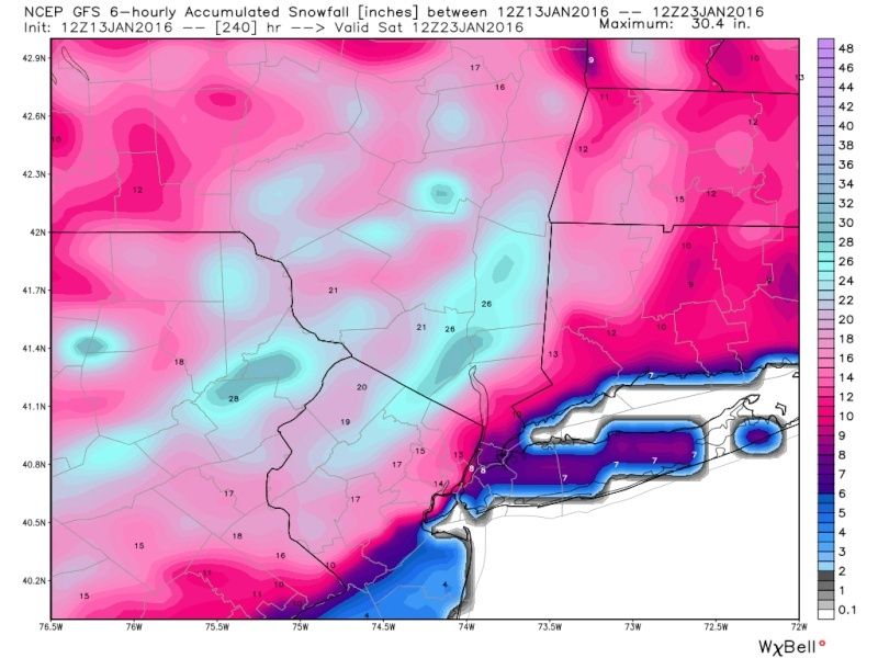
Frank_Wx wrote:The 12z GFS shows a Godzilla next Friday.
That was sroc's original date.
Guest- Guest
Re: Wx Banter Thread 2.0
![]() by Snowfall Wed Jan 13, 2016 12:19 pm
by Snowfall Wed Jan 13, 2016 12:19 pm
Snowfall- Posts : 59
Reputation : 0
Join date : 2015-12-31
Re: Wx Banter Thread 2.0
![]() by jmanley32 Wed Jan 13, 2016 12:21 pm
by jmanley32 Wed Jan 13, 2016 12:21 pm

jmanley32- Senior Enthusiast

- Posts : 20513
Reputation : 108
Join date : 2013-12-12
Age : 42
Location : Yonkers, NY
Re: Wx Banter Thread 2.0
![]() by algae888 Wed Jan 13, 2016 12:38 pm
by algae888 Wed Jan 13, 2016 12:38 pm
algae888- Advanced Forecaster
- Posts : 5311
Reputation : 46
Join date : 2013-02-05
Age : 61
Location : mt. vernon, new york
Re: Wx Banter Thread 2.0
![]() by CPcantmeasuresnow Wed Jan 13, 2016 12:46 pm
by CPcantmeasuresnow Wed Jan 13, 2016 12:46 pm
algae888 wrote:What a wennie run on todays gfs.lol just when you've given up it tries to reel you back in. Don't believe it! if it was anywhere near close to being correct this winter we'd have over 100 inches of snow by now no other model does this
Exactly Al, there I am in the jackpot again (eastern Orange County) 10 days out with a projected 30+ inches of snow. This is the fourth storm this year that I've had that 10 days out, so this storm would theoretically put me at about 120-150 inches so far this season, I have currently measured 0.9 inches. It's laughable.
CPcantmeasuresnow- Wx Statistician Guru
- Posts : 7274
Reputation : 230
Join date : 2013-01-07
Age : 103
Location : Eastern Orange County, NY
Re: Wx Banter Thread 2.0
![]() by jmanley32 Wed Jan 13, 2016 12:48 pm
by jmanley32 Wed Jan 13, 2016 12:48 pm
jmanley32- Senior Enthusiast
- Posts : 20513
Reputation : 108
Join date : 2013-12-12
Age : 42
Location : Yonkers, NY
Re: Wx Banter Thread 2.0
![]() by Guest Wed Jan 13, 2016 1:15 pm
by Guest Wed Jan 13, 2016 1:15 pm
CPcantmeasuresnow wrote:algae888 wrote:What a wennie run on todays gfs.lol just when you've given up it tries to reel you back in. Don't believe it! if it was anywhere near close to being correct this winter we'd have over 100 inches of snow by now no other model does this
Exactly Al, there I am in the jackpot again (eastern Orange County) 10 days out with a projected 30+ inches of snow. This is the fourth storm this year that I've had that 10 days out, so this storm would theoretically put me at about 120-150 inches so far this season, I have currently measured 0.9 inches. It's laughable.
Let's not get reeled in again. 9 days out. If it's still there in 5 days I'll pay attention.
Guest- Guest
Re: Wx Banter Thread 2.0
![]() by Guest Wed Jan 13, 2016 1:16 pm
by Guest Wed Jan 13, 2016 1:16 pm
Just for giggles. Talk about a tight gradient totals range from 2" to 18" across Staten Island!!!jmanley32 wrote:Actually Frank for some verbatim its a roidzilla (and this snow totals its not even done yet), not even thinking 10 days out now, learned my forgotten reality lesson with Sat, closest I will think about is Monday.
Guest- Guest
Re: Wx Banter Thread 2.0
![]() by hyde345 Wed Jan 13, 2016 1:23 pm
by hyde345 Wed Jan 13, 2016 1:23 pm
Frank_Wx wrote:The 12z GFS shows a Godzilla next Friday.
I don't trust the GFS at all beyond 5 days. Does the Euro show anything in that time frame?

hyde345- Pro Enthusiast

- Posts : 1082
Reputation : 48
Join date : 2013-01-08
Location : Hyde Park, NY
Re: Wx Banter Thread 2.0
![]() by jmanley32 Wed Jan 13, 2016 1:47 pm
by jmanley32 Wed Jan 13, 2016 1:47 pm
jmanley32- Senior Enthusiast
- Posts : 20513
Reputation : 108
Join date : 2013-12-12
Age : 42
Location : Yonkers, NY
Re: Wx Banter Thread 2.0
![]() by jmanley32 Wed Jan 13, 2016 1:48 pm
by jmanley32 Wed Jan 13, 2016 1:48 pm
syosnow94 wrote:Just for giggles. Talk about a tight gradient totals range from 2" to 18" across Staten Island!!!jmanley32 wrote:Actually Frank for some verbatim its a roidzilla (and this snow totals its not even done yet), not even thinking 10 days out now, learned my forgotten reality lesson with Sat, closest I will think about is Monday.

The snow model is not good at all especially far out, the coast for some reason gets all messed up like the weird protrusion of LI, don't pay it much mind was just for fun.
jmanley32- Senior Enthusiast
- Posts : 20513
Reputation : 108
Join date : 2013-12-12
Age : 42
Location : Yonkers, NY

RJB8525- Senior Enthusiast
- Posts : 1994
Reputation : 28
Join date : 2013-02-06
Age : 38
Location : Hackettstown, NJ
Re: Wx Banter Thread 2.0
![]() by algae888 Wed Jan 13, 2016 2:04 pm
by algae888 Wed Jan 13, 2016 2:04 pm

algae888- Advanced Forecaster
- Posts : 5311
Reputation : 46
Join date : 2013-02-05
Age : 61
Location : mt. vernon, new york
Re: Wx Banter Thread 2.0
![]() by sroc4 Wed Jan 13, 2016 2:15 pm
by sroc4 Wed Jan 13, 2016 2:15 pm
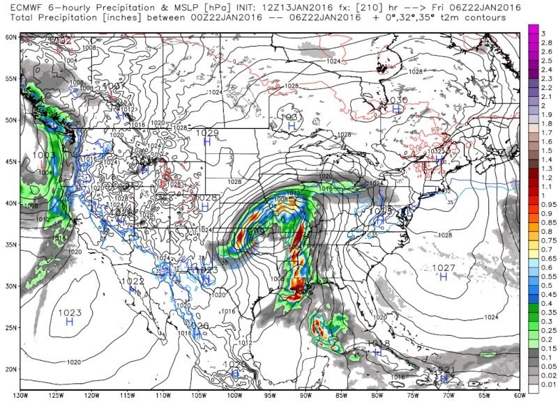
algae888 wrote:and the euro brings us back to reality...
It actually trended better Al...this was the 00z

_________________
"In weather and in life, there's no winning and losing; there's only winning and learning."
WINTER 2012/2013 TOTALS 43.65"WINTER 2017/2018 TOTALS 62.85" WINTER 2022/2023 TOTALS 4.9"
WINTER 2013/2014 TOTALS 64.85"WINTER 2018/2019 TOTALS 14.25" WINTER 2023/2024 TOTALS 13.1"
WINTER 2014/2015 TOTALS 71.20"WINTER 2019/2020 TOTALS 6.35"
WINTER 2015/2016 TOTALS 35.00"WINTER 2020/2021 TOTALS 37.75"
WINTER 2016/2017 TOTALS 42.25"WINTER 2021/2022 TOTALS 31.65"
sroc4- Admin
- Posts : 8331
Reputation : 301
Join date : 2013-01-07
Location : Wading River, LI
Re: Wx Banter Thread 2.0
![]() by algae888 Wed Jan 13, 2016 2:20 pm
by algae888 Wed Jan 13, 2016 2:20 pm
algae888- Advanced Forecaster
- Posts : 5311
Reputation : 46
Join date : 2013-02-05
Age : 61
Location : mt. vernon, new york
Re: Wx Banter Thread 2.0
![]() by sroc4 Wed Jan 13, 2016 2:48 pm
by sroc4 Wed Jan 13, 2016 2:48 pm
_________________
"In weather and in life, there's no winning and losing; there's only winning and learning."
WINTER 2012/2013 TOTALS 43.65"WINTER 2017/2018 TOTALS 62.85" WINTER 2022/2023 TOTALS 4.9"
WINTER 2013/2014 TOTALS 64.85"WINTER 2018/2019 TOTALS 14.25" WINTER 2023/2024 TOTALS 13.1"
WINTER 2014/2015 TOTALS 71.20"WINTER 2019/2020 TOTALS 6.35"
WINTER 2015/2016 TOTALS 35.00"WINTER 2020/2021 TOTALS 37.75"
WINTER 2016/2017 TOTALS 42.25"WINTER 2021/2022 TOTALS 31.65"
sroc4- Admin
- Posts : 8331
Reputation : 301
Join date : 2013-01-07
Location : Wading River, LI
Re: Wx Banter Thread 2.0
![]() by NjWeatherGuy Wed Jan 13, 2016 2:55 pm
by NjWeatherGuy Wed Jan 13, 2016 2:55 pm
http://mag.ncep.noaa.gov/Image.php?fhr=237&image=data%2Fgfs%2F12%2Fgfs_namer_237_850_temp_mslp_precip.gif&model=gfs&area=namer¶m=850_temp_mslp_precip&group=Model+Guidance&preselected_formatted_cycle_date=20160113+12+UTC&imageSize=M&ps=model

NjWeatherGuy- Advanced Forecaster
- Posts : 4100
Reputation : 28
Join date : 2013-01-06
Location : Belle Mead, NJ
Re: Wx Banter Thread 2.0
![]() by sroc4 Wed Jan 13, 2016 2:59 pm
by sroc4 Wed Jan 13, 2016 2:59 pm
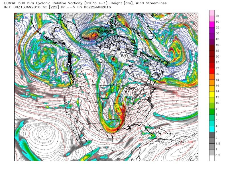
algae888 wrote:scott I don't think so. it looks like it just slowed it down. the next frame on today's 12z would look like 00z from last night. snow produces snow and cutters are going to cut. this pattern has been very stubborn. even though 500mb has changed storm track remains basically the same.
The reason its slowed down is because HP to the north is much stronger and the ridge out west is more amped.

.

Again way to much time to take anything serious. It will change 18 more times. To many things have to shake out ahead of it first
_________________
"In weather and in life, there's no winning and losing; there's only winning and learning."
WINTER 2012/2013 TOTALS 43.65"WINTER 2017/2018 TOTALS 62.85" WINTER 2022/2023 TOTALS 4.9"
WINTER 2013/2014 TOTALS 64.85"WINTER 2018/2019 TOTALS 14.25" WINTER 2023/2024 TOTALS 13.1"
WINTER 2014/2015 TOTALS 71.20"WINTER 2019/2020 TOTALS 6.35"
WINTER 2015/2016 TOTALS 35.00"WINTER 2020/2021 TOTALS 37.75"
WINTER 2016/2017 TOTALS 42.25"WINTER 2021/2022 TOTALS 31.65"
sroc4- Admin
- Posts : 8331
Reputation : 301
Join date : 2013-01-07
Location : Wading River, LI
Page 5 of 40 • 1, 2, 3, 4, 5, 6 ... 22 ... 40 ![]()
|
|
|