
 Search
Long Range Thread 10.0
Page 12 of 28 •  1 ... 7 ... 11, 12, 13 ... 20 ... 28
 ![]()
Re: Long Range Thread 10.0
![]() by lglickman1 Tue Feb 09, 2016 10:34 am
by lglickman1 Tue Feb 09, 2016 10:34 am
lglickman1- Pro Enthusiast

- Posts : 319
Join date : 2013-02-05
Re: Long Range Thread 10.0
![]() by algae888 Tue Feb 09, 2016 12:39 pm
by algae888 Tue Feb 09, 2016 12:39 pm
algae888- Advanced Forecaster

- Posts : 5311
Join date : 2013-02-05
Re: Long Range Thread 10.0
![]() by algae888 Tue Feb 09, 2016 12:42 pm
by algae888 Tue Feb 09, 2016 12:42 pm

algae888- Advanced Forecaster
- Posts : 5311
Reputation : 46
Join date : 2013-02-05
Age : 61
Location : mt. vernon, new york
Re: Long Range Thread 10.0
![]() by skinsfan1177 Tue Feb 09, 2016 12:46 pm
by skinsfan1177 Tue Feb 09, 2016 12:46 pm

skinsfan1177- Senior Enthusiast

- Posts : 4485
Reputation : 35
Join date : 2013-01-07
Age : 46
Location : Point Pleasant Boro
Re: Long Range Thread 10.0
![]() by sroc4 Tue Feb 09, 2016 12:49 pm
by sroc4 Tue Feb 09, 2016 12:49 pm
algae888 wrote:Cmc has a huge storm for Presidents Day. GFS not so much
Ehh typical GFS progressive bias. Its a little to fast with the trough but its there. Going to have to see what the HP trends do. Progressive pattern is possible, but if it phases better it will generate its own cold air. As it looks now the timing of the LP is such that the HP is already on its way out which would mean stale air; no fresh inj of cold air unless it phases. However, if there is a snow pack still in place...well I shouldn't get too far ahead of myself here. Signal is there for now.
CMC:


GFS:


_________________
"In weather and in life, there's no winning and losing; there's only winning and learning."
WINTER 2012/2013 TOTALS 43.65"WINTER 2017/2018 TOTALS 62.85" WINTER 2022/2023 TOTALS 4.9"
WINTER 2013/2014 TOTALS 64.85"WINTER 2018/2019 TOTALS 14.25" WINTER 2023/2024 TOTALS 13.1"
WINTER 2014/2015 TOTALS 71.20"WINTER 2019/2020 TOTALS 6.35"
WINTER 2015/2016 TOTALS 35.00"WINTER 2020/2021 TOTALS 37.75"
WINTER 2016/2017 TOTALS 42.25"WINTER 2021/2022 TOTALS 31.65"

sroc4- Admin

- Posts : 8331
Reputation : 301
Join date : 2013-01-07
Location : Wading River, LI
Re: Long Range Thread 10.0
![]() by algae888 Tue Feb 09, 2016 1:53 pm
by algae888 Tue Feb 09, 2016 1:53 pm
algae888- Advanced Forecaster
- Posts : 5311
Reputation : 46
Join date : 2013-02-05
Age : 61
Location : mt. vernon, new york
Re: Long Range Thread 10.0
![]() by amugs Tue Feb 09, 2016 2:48 pm
by amugs Tue Feb 09, 2016 2:48 pm
Trop forcing too strong and block it basically and now we are heading into teh colder phase even though we were suppose to be in a warm - hmmm 0 to Neg 5 in a warm phase of mjo albeit weak??
_________________
Mugs
AKA:King: Snow Weenie
Self Proclaimed
WINTER 2014-15 : 55.12" +.02 for 6 coatings (avg. 35")
WINTER 2015-16 Total - 29.8" (Avg 35")
WINTER 2016-17 : 39.5" so far

amugs- Advanced Forecaster - Mod

- Posts : 15093
Reputation : 213
Join date : 2013-01-07
Age : 54
Location : Hillsdale,NJ
Re: Long Range Thread 10.0
![]() by skinsfan1177 Tue Feb 09, 2016 3:29 pm
by skinsfan1177 Tue Feb 09, 2016 3:29 pm
skinsfan1177- Senior Enthusiast
- Posts : 4485
Reputation : 35
Join date : 2013-01-07
Age : 46
Location : Point Pleasant Boro
Re: Long Range Thread 10.0
![]() by algae888 Tue Feb 09, 2016 3:40 pm
by algae888 Tue Feb 09, 2016 3:40 pm
mugs look where the gfs takes us!!!amugs wrote:For those who were saying MJO would kill us in Feb -well look again and where we are going?
Trop forcing too strong and block it basically and now we are heading into teh colder phase even though we were suppose to be in a warm - hmmm 0 to Neg 5 in a warm phase of mjo albeit weak??

algae888- Advanced Forecaster
- Posts : 5311
Reputation : 46
Join date : 2013-02-05
Age : 61
Location : mt. vernon, new york
Re: Long Range Thread 10.0
![]() by amugs Tue Feb 09, 2016 3:52 pm
by amugs Tue Feb 09, 2016 3:52 pm
Look at this from Ventrice - phase 4&5 in a Godzilla Nino and look at the east - LIAR LIAR WEST IS ON FIRE!!!!!!!!!!!!!!!!!!!!!!!! It should be the other way around - to bad suckers!!!
_________________
Mugs
AKA:King: Snow Weenie
Self Proclaimed
WINTER 2014-15 : 55.12" +.02 for 6 coatings (avg. 35")
WINTER 2015-16 Total - 29.8" (Avg 35")
WINTER 2016-17 : 39.5" so far
amugs- Advanced Forecaster - Mod
- Posts : 15093
Reputation : 213
Join date : 2013-01-07
Age : 54
Location : Hillsdale,NJ
Re: Long Range Thread 10.0
![]() by frank 638 Tue Feb 09, 2016 5:31 pm
by frank 638 Tue Feb 09, 2016 5:31 pm
frank 638- Senior Enthusiast
- Posts : 2824
Reputation : 37
Join date : 2016-01-01
Age : 40
Location : bronx ny
Re: Long Range Thread 10.0
![]() by skinsfan1177 Tue Feb 09, 2016 5:59 pm
by skinsfan1177 Tue Feb 09, 2016 5:59 pm
skinsfan1177- Senior Enthusiast
- Posts : 4485
Reputation : 35
Join date : 2013-01-07
Age : 46
Location : Point Pleasant Boro
Re: Long Range Thread 10.0
![]() by Frank_Wx Tue Feb 09, 2016 6:02 pm
by Frank_Wx Tue Feb 09, 2016 6:02 pm
Next week is still on the table. EURO has a rainstorm while GFS is cold and out to sea. We'll look into the 16th more on Thursday.
_________________
_______________________________________________________________________________________________________
CLICK HERE to view NJ Strong Snowstorm Classifications

Frank_Wx- Godzilla Seeker
- Posts : 21305
Reputation : 328
Join date : 2013-01-05
Age : 31
Location : Jersey City, NJ -

Re: Long Range Thread 10.0
![]() by rb924119 Tue Feb 09, 2016 9:30 pm
by rb924119 Tue Feb 09, 2016 9:30 pm
rb924119- Meteorologist

- Posts : 6890
Reputation : 194
Join date : 2013-02-06
Age : 32
Location : Greentown, Pa
Re: Long Range Thread 10.0
![]() by CPcantmeasuresnow Wed Feb 10, 2016 1:02 am
by CPcantmeasuresnow Wed Feb 10, 2016 1:02 am
algae888 wrote:Euro has the storm a day later bombs out right over us don't have temp profiles but mixing issues would be a concern Again a Hudson Valley special
There's no such thing Al, It's a myth that died in 2012.

CPcantmeasuresnow- Wx Statistician Guru

- Posts : 7274
Reputation : 230
Join date : 2013-01-07
Age : 103
Location : Eastern Orange County, NY
Re: Long Range Thread 10.0
![]() by snow247 Wed Feb 10, 2016 4:23 am
by snow247 Wed Feb 10, 2016 4:23 am

snow247- Pro Enthusiast
- Posts : 2417
Reputation : 0
Join date : 2014-08-27
Location : Mount Ivy, NY - Elevation 545'
Re: Long Range Thread 10.0
![]() by skinsfan1177 Wed Feb 10, 2016 5:05 am
by skinsfan1177 Wed Feb 10, 2016 5:05 am
skinsfan1177- Senior Enthusiast
- Posts : 4485
Reputation : 35
Join date : 2013-01-07
Age : 46
Location : Point Pleasant Boro
Re: Long Range Thread 10.0
![]() by frank 638 Wed Feb 10, 2016 6:10 am
by frank 638 Wed Feb 10, 2016 6:10 am
frank 638- Senior Enthusiast
- Posts : 2824
Reputation : 37
Join date : 2016-01-01
Age : 40
Location : bronx ny
Re: Long Range Thread 10.0
![]() by sroc4 Wed Feb 10, 2016 7:42 am
by sroc4 Wed Feb 10, 2016 7:42 am
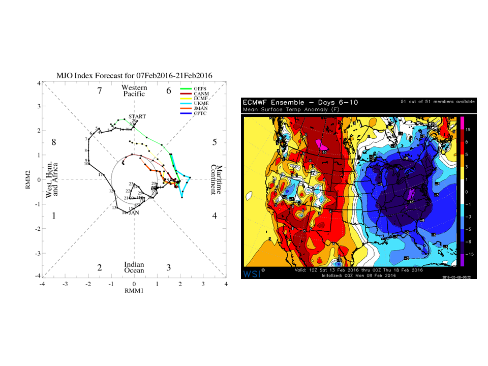
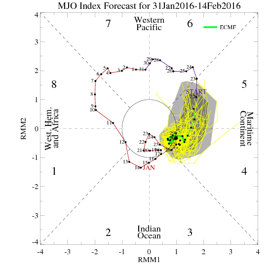
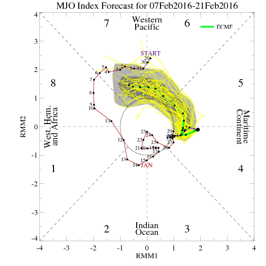
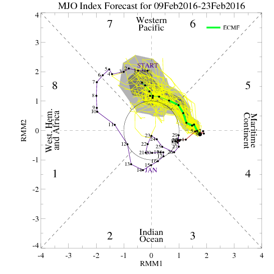
I have been tracking the MJO since our last discussion on it when many were canceling winter back at the end of Jan, and I and a few others stated how some of the other drivers are likely to mute the MJO's influence on North America. Well that has def occurred; esp seeing is that this weekend is going to be potentially record breaking cold despite being smack dab in themiddle of one of the warmest phases of the MJO.
We will see the NE warm back up again midweek next week for a few days. NOW HEAR THIS: This WILL NOT be the end of winter!! Just like the first 5days of Feb the warm up will be another reload. It will set us back up again for the final push of winter. Yes I know many of my HV and NW peeps winter really never has shown up, but in general given the strength of such an El Nino and the amount of time we have spent in unfavorable MJO phases, this winter has and will cont to exceed expectations. I am sitting at a tick above 30" for the season and still very confidently expect to see 50+ IMBY by April 1st.
Here is the MJO forecasts for the Euro only beginning back on Jan 31st. I cont to believe that the MJO influences will be tempered by the other drivers; however, as Rb has eluded to when/IF the MJO makes it into some of the colder phases and the MJO and other divers for cold and snow actually align, the last 7-10ays of Feb into the first 2 weeks of march eally could be special. I will hold the phone on going any further at this point.
One last point and once again is an extremely important one. Models will not have a handle on what is to happen beyond mid week next week through next weekend and beyond because the atmosphere will be undergoing the reload. They NEVER have a handle on the LR during those time periods, so DO NOT PANIC NEXT WEEK WHEN LOOKING AT THE LR MODELING!!!! One last hoorah OF AT LEAST 2-3WEEKS IS COMING. I think before we call it a season.


_________________
"In weather and in life, there's no winning and losing; there's only winning and learning."
WINTER 2012/2013 TOTALS 43.65"WINTER 2017/2018 TOTALS 62.85" WINTER 2022/2023 TOTALS 4.9"
WINTER 2013/2014 TOTALS 64.85"WINTER 2018/2019 TOTALS 14.25" WINTER 2023/2024 TOTALS 13.1"
WINTER 2014/2015 TOTALS 71.20"WINTER 2019/2020 TOTALS 6.35"
WINTER 2015/2016 TOTALS 35.00"WINTER 2020/2021 TOTALS 37.75"
WINTER 2016/2017 TOTALS 42.25"WINTER 2021/2022 TOTALS 31.65"
sroc4- Admin
- Posts : 8331
Reputation : 301
Join date : 2013-01-07
Location : Wading River, LI
Re: Long Range Thread 10.0
![]() by amugs Wed Feb 10, 2016 7:52 am
by amugs Wed Feb 10, 2016 7:52 am
rb924119 wrote:MJO phase 7 is warm for the East in February, and will likely be partly responsible for the warmup next week. I posted earlier in this thread about this, BUT where the MJO goes after phase 7 (I.e. Phases 8-2/3) at a strong amplitude aided by ENSO and another battering of Stratospheric flux transfer to upset the PV (again) that will lead to another below-normal and stormy stretch starting around the 21-24th time-period, which is why I'm very excited for that period and another possible large storm threat.
Ray, true but look at phase 4 and 5 and 6 for the east and what we've had - those are all out torches. In this winter nino and strong trop forcing nothing is going by the book
_________________
Mugs
AKA:King: Snow Weenie
Self Proclaimed
WINTER 2014-15 : 55.12" +.02 for 6 coatings (avg. 35")
WINTER 2015-16 Total - 29.8" (Avg 35")
WINTER 2016-17 : 39.5" so far
amugs- Advanced Forecaster - Mod
- Posts : 15093
Reputation : 213
Join date : 2013-01-07
Age : 54
Location : Hillsdale,NJ
Re: Long Range Thread 10.0
![]() by weatherwatchermom Wed Feb 10, 2016 8:26 am
by weatherwatchermom Wed Feb 10, 2016 8:26 am
sroc4 wrote:For me the last 2 weeks, and the next 2-4weeks is like a rugby scrum amongst the main drivers of the pattern. On one side you have a strong el nino, and an MJO in the warm phases, and on the other side you have stratospheric influences, the +PDO, +PNA, -EPO, at times -AO. You get a push from one side, then a push back from the other. Overall however, the latter influences have been slowly winning out as the winter has progressed leading to shorter warm ups, and more in the way of colder and snowier pattern. Unfort this past week did not produce as much snow for everyone as their was potential, but overall it did produce 3 waves within a short time. That same potential exists again after next weeks brief warm up.
I have been tracking the MJO since our last discussion on it when many were canceling winter back at the end of Jan, and I and a few others stated how some of the other drivers are likely to mute the MJO's influence on North America. Well that has def occurred; esp seeing is that this weekend is going to be potentially record breaking cold despite being smack dab in themiddle of one of the warmest phases of the MJO.
We will see the NE warm back up again midweek next week for a few days. NOW HEAR THIS: This WILL NOT be the end of winter!! Just like the first 5days of Feb the warm up will be another reload. It will set us back up again for the final push of winter. Yes I know many of my HV and NW peeps winter really never has shown up, but in general given the strength of such an El Nino and the amount of time we have spent in unfavorable MJO phases, this winter has and will cont to exceed expectations. I am sitting at a tick above 30" for the season and still very confidently expect to see 50+ IMBY by April 1st.
Here is the MJO forecasts for the Euro only beginning back on Jan 31st. I cont to believe that the MJO influences will be tempered by the other drivers; however, as Rb has eluded to when/IF the MJO makes it into some of the colder phases and the MJO and other divers for cold and snow actually align, the last 7-10ays of Feb into the first 2 weeks of march eally could be special. I will hold the phone on going any further at this point.
One last point and once again is an extremely important one. Models will not have a handle on what is to happen beyond mid week next week through next weekend and beyond because the atmosphere will be undergoing the reload. They NEVER have a handle on the LR during those time periods, so DO NOT PANIC NEXT WEEK WHEN LOOKING AT THE LR MODELING!!!! One last hoorah OF AT LEAST 2-3WEEKS IS COMING. I think before we call it a season.
thanks for you words that always bring us back from the edge of that cliff! after the last couple of days I have been edging closer to the cliff..and I generally am a glass half full kind of gal

weatherwatchermom- Senior Enthusiast
- Posts : 3738
Reputation : 77
Join date : 2014-11-25
Age : 60
Location : Hazlet Township, NJ
Re: Long Range Thread 10.0
![]() by rb924119 Wed Feb 10, 2016 8:36 am
by rb924119 Wed Feb 10, 2016 8:36 am
rb924119- Meteorologist
- Posts : 6890
Reputation : 194
Join date : 2013-02-06
Age : 32
Location : Greentown, Pa
Re: Long Range Thread 10.0
![]() by amugs Wed Feb 10, 2016 9:27 am
by amugs Wed Feb 10, 2016 9:27 am
_________________
Mugs
AKA:King: Snow Weenie
Self Proclaimed
WINTER 2014-15 : 55.12" +.02 for 6 coatings (avg. 35")
WINTER 2015-16 Total - 29.8" (Avg 35")
WINTER 2016-17 : 39.5" so far
amugs- Advanced Forecaster - Mod
- Posts : 15093
Reputation : 213
Join date : 2013-01-07
Age : 54
Location : Hillsdale,NJ
Re: Long Range Thread 10.0
![]() by keliza52 Wed Feb 10, 2016 11:33 am
by keliza52 Wed Feb 10, 2016 11:33 am
_____
Karen

keliza52- Posts : 51
Reputation : 0
Join date : 2013-12-08
Location : Hackettstown, NJ
Re: Long Range Thread 10.0
![]() by sroc4 Wed Feb 10, 2016 11:35 am
by sroc4 Wed Feb 10, 2016 11:35 am
keliza52 wrote:Thank you Sroc for the detailed explanation. I feel much better now. You don't hear from me much I too was on the edge of that cliff!
_____
Karen
 Karen and weatherwatchermom. Obv I cant tell you if an individual backyard will get more snow but the chances should be there.
 _________________
"In weather and in life, there's no winning and losing; there's only winning and learning."
WINTER 2012/2013 TOTALS 43.65"WINTER 2017/2018 TOTALS 62.85" WINTER 2022/2023 TOTALS 4.9"
WINTER 2013/2014 TOTALS 64.85"WINTER 2018/2019 TOTALS 14.25" WINTER 2023/2024 TOTALS 13.1"
WINTER 2014/2015 TOTALS 71.20"WINTER 2019/2020 TOTALS 6.35"
WINTER 2015/2016 TOTALS 35.00"WINTER 2020/2021 TOTALS 37.75"
WINTER 2016/2017 TOTALS 42.25"WINTER 2021/2022 TOTALS 31.65"
sroc4- Admin
- Posts : 8331
Reputation : 301
Join date : 2013-01-07
Location : Wading River, LI
Re: Long Range Thread 10.0
![]() by algae888 Wed Feb 10, 2016 12:06 pm
by algae888 Wed Feb 10, 2016 12:06 pm
algae888- Advanced Forecaster
- Posts : 5311
Reputation : 46
Join date : 2013-02-05
Age : 61
Location : mt. vernon, new york
Re: Long Range Thread 10.0
![]() by jmanley32 Wed Feb 10, 2016 12:34 pm
by jmanley32 Wed Feb 10, 2016 12:34 pm
algae888 wrote:So far today's model runs are blah. Monday Tuesday looks like a snow to rain at this point. Then a brief warm up hopefully we get cold again with one last shot at this winter. I don't know if it's too early yet to talk about the winter of 16/17 but with El Nino weekening slower than expected next year may end up with a week Nina. Similar to 94/95 nino then 95/96 weak nina. I'm hearing 95/96 is the best analog for next winter.
Do not recall was that a good winter? Yeah at this point sorry guys but its just been big disappointments since last Friday, and the future weeks sound bleak before we get into nearing springtime. Honestly I am ready for spring. And bring on hurricane season LOL, I hear it may be a doozy

jmanley32- Senior Enthusiast
- Posts : 20516
Reputation : 108
Join date : 2013-12-12
Age : 42
Location : Yonkers, NY
Page 12 of 28 • 1 ... 7 ... 11, 12, 13 ... 20 ... 28 ![]()
|
|
|