
 Search
Hurricane Hermine Discussion
Page 18 of 40 •  1 ... 10 ... 17, 18, 19 ... 29 ... 40
 ![]()
snow247- Pro Enthusiast

- Posts : 2417
Join date : 2014-08-27
Re: Hurricane Hermine Discussion
![]() by HectorO Thu Sep 01, 2016 4:11 pm
by HectorO Thu Sep 01, 2016 4:11 pm
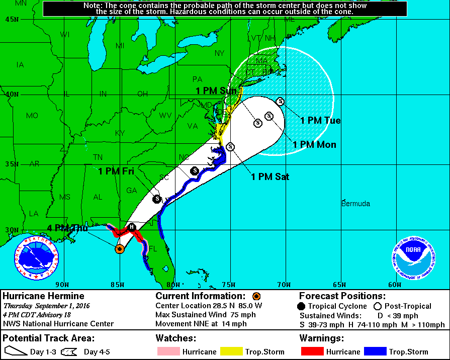
jmanley32 wrote:I agree syo. And it won't take much to get it even more north like mugs said 50 miles and he'll lot eorse. Who knows too maybe the high doesn't suppress ot as much. Can't believe 2 to 3 days away and we don't know for sure.syosnow94 wrote:algae888 wrote:Yes West of I 287 in Jersey and north of I-287 in New York will be on The Fringe of the storm maybe even the immediate New York City area and Long Island as currently modeled. Unless this storm makes landfall between Atlantic City and Long Island they should be spared. the immediate Coast however should have mandatory evacuations. New Jersey coast that isjmanley32 wrote:Al u really think we will b sunny? Im.moving to south jersey lol
Hey Al. A storm of this magnitude located off the Delmarva, ABSOLUTELY brings heave rain up through all of Jersey, SENY and most of CT. Jersey shore impacts would absolutely be worse, but IF it tracks as currently modeled I think you may be underestimating it's N and NW reach.
Not really that hard to believe. I grew up going through hurricanes. When I was in jacksonville Floyd was supposed to be a direct hit at Cat 4 and literally a day before the storm took a sharp turn and slammed into the carolinas. We still got hit with tropical storm like force but in Florida the tropical storm was nothing for us.
Last edited by HectorO on Thu Sep 01, 2016 4:21 pm; edited 1 time in total
HectorO- Pro Enthusiast
- Posts : 959
Join date : 2013-01-11
Re: Hurricane Hermine Discussion
![]() by jmanley32 Thu Sep 01, 2016 4:11 pm
by jmanley32 Thu Sep 01, 2016 4:11 pm
wow further north and these models cab b taken more seriously in this time framesnow247 wrote:Wow

jmanley32- Senior Enthusiast

- Posts : 20516
Reputation : 108
Join date : 2013-12-12
Age : 42
Location : Yonkers, NY
Re: Hurricane Hermine Discussion
![]() by algae888 Thu Sep 01, 2016 4:15 pm
by algae888 Thu Sep 01, 2016 4:15 pm
Yes obviously track could change but looking at GFS total precip the areas I mentioned are under an inch of rain through the entire event CMC is similar don't have euro datasyosnow94 wrote:algae888 wrote:Yes West of I 287 in Jersey and north of I-287 in New York will be on The Fringe of the storm maybe even the immediate New York City area and Long Island as currently modeled. Unless this storm makes landfall between Atlantic City and Long Island they should be spared. the immediate Coast however should have mandatory evacuations. New Jersey coast that isjmanley32 wrote:Al u really think we will b sunny? Im.moving to south jersey lol
Hey Al. A storm of this magnitude located off the Delmarva, ABSOLUTELY brings heave rain up through all of Jersey, SENY and most of CT. Jersey shore impacts would absolutely be worse, but IF it tracks as currently modeled I think you may be underestimating it's N and NW reach.

algae888- Advanced Forecaster

- Posts : 5311
Reputation : 46
Join date : 2013-02-05
Age : 61
Location : mt. vernon, new york
Re: Hurricane Hermine Discussion
![]() by Dunnzoo Thu Sep 01, 2016 4:21 pm
by Dunnzoo Thu Sep 01, 2016 4:21 pm
_________________
Janet
Snowfall winter of 2023-2024 17.5"
Snowfall winter of 2022-2023 6.0"
Snowfall winter of 2021-2022 17.6" 1" sleet 2/25/22
Snowfall winter of 2020-2021 51.1"
Snowfall winter of 2019-2020 8.5"
Snowfall winter of 2018-2019 25.1"
Snowfall winter of 2017-2018 51.9"
Snowfall winter of 2016-2017 45.6"
Snowfall winter of 2015-2016 29.5"
Snowfall winter of 2014-2015 50.55"
Snowfall winter of 2013-2014 66.5"

Dunnzoo- Senior Enthusiast - Mod

- Posts : 4891
Reputation : 68
Join date : 2013-01-11
Age : 62
Location : Westwood, NJ
Re: Hurricane Hermine Discussion
![]() by jmanley32 Thu Sep 01, 2016 4:26 pm
by jmanley32 Thu Sep 01, 2016 4:26 pm
woah that b big impacts for nj and nyc even into hudson valley. Those likely 40 to 50 mph sustained in purple. I still think Franks forecast is on pt for now.snow247 wrote:Wow
jmanley32- Senior Enthusiast
- Posts : 20516
Reputation : 108
Join date : 2013-12-12
Age : 42
Location : Yonkers, NY
Re: Hurricane Hermine Discussion
![]() by jmanley32 Thu Sep 01, 2016 4:29 pm
by jmanley32 Thu Sep 01, 2016 4:29 pm
jmanley32- Senior Enthusiast
- Posts : 20516
Reputation : 108
Join date : 2013-12-12
Age : 42
Location : Yonkers, NY
Re: Hurricane Hermine Discussion
![]() by amugs Thu Sep 01, 2016 4:29 pm
by amugs Thu Sep 01, 2016 4:29 pm

_________________
Mugs
AKA:King: Snow Weenie
Self Proclaimed
WINTER 2014-15 : 55.12" +.02 for 6 coatings (avg. 35")
WINTER 2015-16 Total - 29.8" (Avg 35")
WINTER 2016-17 : 39.5" so far

amugs- Advanced Forecaster - Mod
- Posts : 15093
Reputation : 213
Join date : 2013-01-07
Age : 54
Location : Hillsdale,NJ
Re: Hurricane Hermine Discussion
![]() by amugs Thu Sep 01, 2016 4:31 pm
by amugs Thu Sep 01, 2016 4:31 pm
Dunnzoo wrote:Just don't know how strong that HP to the north will be and how it suppresses the storm. More of a nowcast I think, have to watch the upper levels. Too bad I'm leaving Seaside Park on Saturday morning, would like to see the surf. But I'm sure we are going to have a LOT of company coming up the Parkway early Saturday.
Talking already about mandatory evac for Atlantic and Cape May counties - they could move this to Ocean too IMO
_________________
Mugs
AKA:King: Snow Weenie
Self Proclaimed
WINTER 2014-15 : 55.12" +.02 for 6 coatings (avg. 35")
WINTER 2015-16 Total - 29.8" (Avg 35")
WINTER 2016-17 : 39.5" so far
amugs- Advanced Forecaster - Mod
- Posts : 15093
Reputation : 213
Join date : 2013-01-07
Age : 54
Location : Hillsdale,NJ
Re: Hurricane Hermine Discussion
![]() by amugs Thu Sep 01, 2016 4:33 pm
by amugs Thu Sep 01, 2016 4:33 pm
The HP does not have teh strength to suppress it as much - i fit is slower then we see what is being modelled.
We shall see...
_________________
Mugs
AKA:King: Snow Weenie
Self Proclaimed
WINTER 2014-15 : 55.12" +.02 for 6 coatings (avg. 35")
WINTER 2015-16 Total - 29.8" (Avg 35")
WINTER 2016-17 : 39.5" so far
amugs- Advanced Forecaster - Mod
- Posts : 15093
Reputation : 213
Join date : 2013-01-07
Age : 54
Location : Hillsdale,NJ
Re: Hurricane Hermine Discussion
![]() by jmanley32 Thu Sep 01, 2016 4:39 pm
by jmanley32 Thu Sep 01, 2016 4:39 pm
I've heard gfdl and hwrf can do ok. I'd like to see hwrf as I put more stock in ot. LaSt run was well east.amugs wrote:It seems to be fast than progged which is what the latest HCANE models are showing - this would mean that the storm can push further North as depicted on the GFDL run - if that happens then holy mother of mercy for the NYC Metro area is all I can say.
The HP does not have teh strength to suppress it as much - i fit is slower then we see what is being modelled.
We shall see...
jmanley32- Senior Enthusiast
- Posts : 20516
Reputation : 108
Join date : 2013-12-12
Age : 42
Location : Yonkers, NY
Re: Hurricane Hermine Discussion
![]() by jmanley32 Thu Sep 01, 2016 4:42 pm
by jmanley32 Thu Sep 01, 2016 4:42 pm
jmanley32- Senior Enthusiast
- Posts : 20516
Reputation : 108
Join date : 2013-12-12
Age : 42
Location : Yonkers, NY
Re: Hurricane Hermine Discussion
![]() by jmanley32 Thu Sep 01, 2016 4:44 pm
by jmanley32 Thu Sep 01, 2016 4:44 pm
also gfdl initialized at 985mb the closest any model has. Let's see what happens.jmanley32 wrote:12z hwrf is a miss for all ots. I don't buy that.
Last edited by jmanley32 on Thu Sep 01, 2016 5:21 pm; edited 1 time in total
jmanley32- Senior Enthusiast
- Posts : 20516
Reputation : 108
Join date : 2013-12-12
Age : 42
Location : Yonkers, NY
Re: Hurricane Hermine Discussion
![]() by jmanley32 Thu Sep 01, 2016 4:45 pm
by jmanley32 Thu Sep 01, 2016 4:45 pm
jmanley32- Senior Enthusiast
- Posts : 20516
Reputation : 108
Join date : 2013-12-12
Age : 42
Location : Yonkers, NY
Re: Hurricane Hermine Discussion
![]() by algae888 Thu Sep 01, 2016 4:48 pm
by algae888 Thu Sep 01, 2016 4:48 pm
algae888- Advanced Forecaster
- Posts : 5311
Reputation : 46
Join date : 2013-02-05
Age : 61
Location : mt. vernon, new york
Re: Hurricane Hermine Discussion
![]() by aiannone Thu Sep 01, 2016 4:49 pm
by aiannone Thu Sep 01, 2016 4:49 pm
_________________
-Alex Iannone-

aiannone- Senior Enthusiast - Mod
- Posts : 4813
Reputation : 92
Join date : 2013-01-07
Location : Saint James, LI (Northwest Suffolk Co.)
Re: Hurricane Hermine Discussion
![]() by skinsfan1177 Thu Sep 01, 2016 4:51 pm
by skinsfan1177 Thu Sep 01, 2016 4:51 pm

skinsfan1177- Senior Enthusiast
- Posts : 4485
Reputation : 35
Join date : 2013-01-07
Age : 46
Location : Point Pleasant Boro
Re: Hurricane Hermine Discussion
![]() by jmanley32 Thu Sep 01, 2016 4:52 pm
by jmanley32 Thu Sep 01, 2016 4:52 pm
wow already! And al it's the Nam lol but this is go all over the place so anything seems still b on table.aiannone wrote:Tropical Storm Watches now up for NJ
jmanley32- Senior Enthusiast
- Posts : 20516
Reputation : 108
Join date : 2013-12-12
Age : 42
Location : Yonkers, NY
Re: Hurricane Hermine Discussion
![]() by amugs Thu Sep 01, 2016 4:53 pm
by amugs Thu Sep 01, 2016 4:53 pm
OH BOY !!
_________________
Mugs
AKA:King: Snow Weenie
Self Proclaimed
WINTER 2014-15 : 55.12" +.02 for 6 coatings (avg. 35")
WINTER 2015-16 Total - 29.8" (Avg 35")
WINTER 2016-17 : 39.5" so far
amugs- Advanced Forecaster - Mod
- Posts : 15093
Reputation : 213
Join date : 2013-01-07
Age : 54
Location : Hillsdale,NJ
Re: Hurricane Hermine Discussion
![]() by skinsfan1177 Thu Sep 01, 2016 4:54 pm
by skinsfan1177 Thu Sep 01, 2016 4:54 pm
skinsfan1177- Senior Enthusiast
- Posts : 4485
Reputation : 35
Join date : 2013-01-07
Age : 46
Location : Point Pleasant Boro
Re: Hurricane Hermine Discussion
![]() by jmanley32 Thu Sep 01, 2016 4:56 pm
by jmanley32 Thu Sep 01, 2016 4:56 pm
is that track slightly more west and still ne. Dunno what they are seeing. Yes skins no consistant this bad. First time ever tropucal entity a few days away at best and no one knows.amugs wrote:
OH BOY !!
jmanley32- Senior Enthusiast
- Posts : 20516
Reputation : 108
Join date : 2013-12-12
Age : 42
Location : Yonkers, NY
Re: Hurricane Hermine Discussion
![]() by skinsfan1177 Thu Sep 01, 2016 4:58 pm
by skinsfan1177 Thu Sep 01, 2016 4:58 pm
jmanley32 wrote:is that track slightly more west and still ne. Dunno what they are seeing. Yes skins no consistant this bad. First time ever tropucal entity a few days away at best and no one knows.amugs wrote:
OH BOY !!
Jman didn't a lot of models show a bad storm today
skinsfan1177- Senior Enthusiast
- Posts : 4485
Reputation : 35
Join date : 2013-01-07
Age : 46
Location : Point Pleasant Boro
Re: Hurricane Hermine Discussion
![]() by jmanley32 Thu Sep 01, 2016 4:58 pm
by jmanley32 Thu Sep 01, 2016 4:58 pm
jmanley32- Senior Enthusiast
- Posts : 20516
Reputation : 108
Join date : 2013-12-12
Age : 42
Location : Yonkers, NY
Re: Hurricane Hermine Discussion
![]() by jmanley32 Thu Sep 01, 2016 5:01 pm
by jmanley32 Thu Sep 01, 2016 5:01 pm
Yes but mainly very southern jersey but now nhc has watches up to ny border so I think this go b further north. It's not moving slow and as dunno said it might push high up a bit. I see it intensify too more than models show posdibly. They can't handle the transition to post right now. This is getting exciting and nervous same time.skinsfan1177 wrote:jmanley32 wrote:is that track slightly more west and still ne. Dunno what they are seeing. Yes skins no consistant this bad. First time ever tropucal entity a few days away at best and no one knows.amugs wrote:
OH BOY !!
Jman didn't a lot of models show a bad storm today
jmanley32- Senior Enthusiast
- Posts : 20516
Reputation : 108
Join date : 2013-12-12
Age : 42
Location : Yonkers, NY
Re: Hurricane Hermine Discussion
![]() by Frank_Wx Thu Sep 01, 2016 5:02 pm
by Frank_Wx Thu Sep 01, 2016 5:02 pm
_________________
_______________________________________________________________________________________________________
CLICK HERE to view NJ Strong Snowstorm Classifications

Frank_Wx- Godzilla Seeker

- Posts : 21305
Reputation : 328
Join date : 2013-01-05
Age : 31
Location : Jersey City, NJ -

Re: Hurricane Hermine Discussion
![]() by weatherwatchermom Thu Sep 01, 2016 5:04 pm
by weatherwatchermom Thu Sep 01, 2016 5:04 pm
amugs wrote:Alignment of the models
GFS,EURO, GEM, GEFS and EURO ENS - UKIE coming around to the retrograde.
IF I live along the coast I would start to get things in order and I think after Frank our fearless leader digests the model runs and data from today he will concur.
They ain't going to sound the alarms until Friday night or Saturday morning but we are always ahead of the curve on this board - VIVA NJ STRONG!!!!
just got home..had some last minute fun stuff before school starts..on Tues...we stopped at costco on way home to get water and stuff...will start our prep tom..husband off from work....I really hope this thing goes out to sea!!

weatherwatchermom- Senior Enthusiast
- Posts : 3742
Reputation : 77
Join date : 2014-11-25
Age : 60
Location : Hazlet Township, NJ
Re: Hurricane Hermine Discussion
![]() by jmanley32 Thu Sep 01, 2016 5:05 pm
by jmanley32 Thu Sep 01, 2016 5:05 pm
just the beaches frank or a bit inland too? Al was say could n fine in nyc area. I guess I'll let u b and read ur blog tonight but please mention what u expect for my area li etc not just jersey shore. Thpugh they most important.Frank_Wx wrote:Those along the coast should prepare for the possibility of Hurricane force winds. The likelihood of those types of winds remain slim, since track is unknown, but surge and tropical storm winds look likely.
jmanley32- Senior Enthusiast
- Posts : 20516
Reputation : 108
Join date : 2013-12-12
Age : 42
Location : Yonkers, NY
Page 18 of 40 • 1 ... 10 ... 17, 18, 19 ... 29 ... 40 ![]()
|
|
|