
 Search
Hurricane Hermine Discussion
Page 31 of 40 •  1 ... 17 ... 30, 31, 32 ... 35 ... 40
 ![]()
Re: Hurricane Hermine Discussion
![]() by Dtone Fri Sep 02, 2016 11:02 am
by Dtone Fri Sep 02, 2016 11:02 am
Dtone- Wx Statistician Guru

- Posts : 1738
Join date : 2013-08-26
Re: Hurricane Hermine Discussion
![]() by weatherwatchermom Fri Sep 02, 2016 11:02 am
by weatherwatchermom Fri Sep 02, 2016 11:02 am
sroc4 wrote:aiannone wrote:
New Track has it remerging into a hurricane of the DE coast.
Ohhh there is an H in there now.
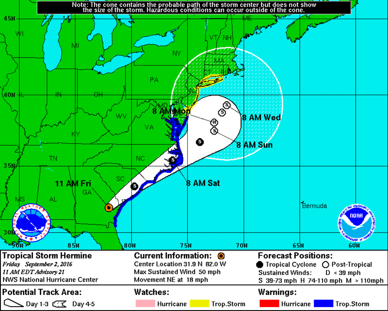
H??
weatherwatchermom- Senior Enthusiast

- Posts : 3735
Join date : 2014-11-25
Re: Hurricane Hermine Discussion
![]() by aiannone Fri Sep 02, 2016 11:02 am
by aiannone Fri Sep 02, 2016 11:02 am
Our area is moving into the likely category
_________________
-Alex Iannone-

aiannone- Senior Enthusiast - Mod

- Posts : 4813
Reputation : 92
Join date : 2013-01-07
Location : Saint James, LI (Northwest Suffolk Co.)
Re: Hurricane Hermine Discussion
![]() by Quietace Fri Sep 02, 2016 11:04 am
by Quietace Fri Sep 02, 2016 11:04 am

I would have most likely kept it PT until 8am Sunday, transitioning back to tropical 8 am Monday, but that just my opinion. You can clearly see the transition on models with the tightening of wind field past that date.

Quietace- Meteorologist - Mod

- Posts : 3687
Reputation : 33
Join date : 2013-01-07
Age : 27
Location : Point Pleasant, NJ
Re: Hurricane Hermine Discussion
![]() by sabamfa Fri Sep 02, 2016 11:05 am
by sabamfa Fri Sep 02, 2016 11:05 am
sabamfa- Pro Enthusiast

- Posts : 246
Reputation : 2
Join date : 2013-11-05
Age : 37
Location : Wayne, NJ
Re: Hurricane Hermine Discussion
![]() by Snow88 Fri Sep 02, 2016 11:07 am
by Snow88 Fri Sep 02, 2016 11:07 am
weatherwatchermom wrote:sroc4 wrote:aiannone wrote:
New Track has it remerging into a hurricane of the DE coast.
Ohhh there is an H in there now.
H??
Hurricane

Snow88- Senior Enthusiast
- Posts : 2193
Reputation : 4
Join date : 2013-01-09
Age : 35
Location : Brooklyn, NY
Re: Hurricane Hermine Discussion
![]() by aiannone Fri Sep 02, 2016 11:07 am
by aiannone Fri Sep 02, 2016 11:07 am
http://abc7ny.com/live/23376/
_________________
-Alex Iannone-
aiannone- Senior Enthusiast - Mod
- Posts : 4813
Reputation : 92
Join date : 2013-01-07
Location : Saint James, LI (Northwest Suffolk Co.)
Re: Hurricane Hermine Discussion
![]() by aiannone Fri Sep 02, 2016 11:07 am
by aiannone Fri Sep 02, 2016 11:07 am
sabamfa wrote:Alex, do you know when there might be a better handle on impacts to northern NJ? I'm trying to determine if I should move my Sunday evening plans to tonight. Thanks!
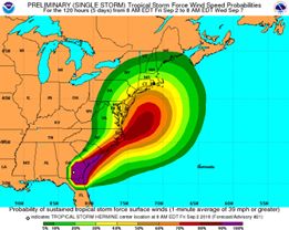
Move them. Sunday evening will be peak impact time if current guidance holds. Better be safe than sorry.
_________________
-Alex Iannone-
aiannone- Senior Enthusiast - Mod
- Posts : 4813
Reputation : 92
Join date : 2013-01-07
Location : Saint James, LI (Northwest Suffolk Co.)
Re: Hurricane Hermine Discussion
![]() by RJB8525 Fri Sep 02, 2016 11:13 am
by RJB8525 Fri Sep 02, 2016 11:13 am

RJB8525- Senior Enthusiast
- Posts : 1994
Reputation : 28
Join date : 2013-02-06
Age : 38
Location : Hackettstown, NJ
Re: Hurricane Hermine Discussion
![]() by Snow88 Fri Sep 02, 2016 11:16 am
by Snow88 Fri Sep 02, 2016 11:16 am
Snow88- Senior Enthusiast
- Posts : 2193
Reputation : 4
Join date : 2013-01-09
Age : 35
Location : Brooklyn, NY
Re: Hurricane Hermine Discussion
![]() by sroc4 Fri Sep 02, 2016 11:18 am
by sroc4 Fri Sep 02, 2016 11:18 am
Snow88 wrote:weatherwatchermom wrote:sroc4 wrote:aiannone wrote:
New Track has it remerging into a hurricane of the DE coast.
Ohhh there is an H in there now.
H??
Hurricane
This...."Hurricane" Post trop hurricane as of Monday am 8am. This is how I feel about it
_________________
"In weather and in life, there's no winning and losing; there's only winning and learning."
WINTER 2012/2013 TOTALS 43.65"WINTER 2017/2018 TOTALS 62.85" WINTER 2022/2023 TOTALS 4.9"
WINTER 2013/2014 TOTALS 64.85"WINTER 2018/2019 TOTALS 14.25" WINTER 2023/2024 TOTALS 13.1"
WINTER 2014/2015 TOTALS 71.20"WINTER 2019/2020 TOTALS 6.35"
WINTER 2015/2016 TOTALS 35.00"WINTER 2020/2021 TOTALS 37.75"
WINTER 2016/2017 TOTALS 42.25"WINTER 2021/2022 TOTALS 31.65"

sroc4- Admin

- Posts : 8331
Reputation : 301
Join date : 2013-01-07
Location : Wading River, LI
Re: Hurricane Hermine Discussion
![]() by weatherwatchermom Fri Sep 02, 2016 11:21 am
by weatherwatchermom Fri Sep 02, 2016 11:21 am
sroc4 wrote:Snow88 wrote:weatherwatchermom wrote:sroc4 wrote:aiannone wrote:
New Track has it remerging into a hurricane of the DE coast.
Ohhh there is an H in there now.
H??
Hurricane
This...."Hurricane" Post trop hurricane as of Monday am 8am. This is how I feel about it
 that is what I thought you meant..hoping not... oh boy...this is crazy!! gotta run my son to school for orientation...can't wait to see how many pages I will be missing...
weatherwatchermom- Senior Enthusiast
- Posts : 3735
Reputation : 77
Join date : 2014-11-25
Age : 60
Location : Hazlet Township, NJ
Re: Hurricane Hermine Discussion
![]() by RJB8525 Fri Sep 02, 2016 11:23 am
by RJB8525 Fri Sep 02, 2016 11:23 am
RJB8525- Senior Enthusiast
- Posts : 1994
Reputation : 28
Join date : 2013-02-06
Age : 38
Location : Hackettstown, NJ
Re: Hurricane Hermine Discussion
![]() by sabamfa Fri Sep 02, 2016 11:30 am
by sabamfa Fri Sep 02, 2016 11:30 am
aiannone wrote:sabamfa wrote:Alex, do you know when there might be a better handle on impacts to northern NJ? I'm trying to determine if I should move my Sunday evening plans to tonight. Thanks!
Move them. Sunday evening will be peak impact time if current guidance holds. Better be safe than sorry.
Thanks, Alex!
sabamfa- Pro Enthusiast
- Posts : 246
Reputation : 2
Join date : 2013-11-05
Age : 37
Location : Wayne, NJ
Re: Hurricane Hermine Discussion
![]() by aiannone Fri Sep 02, 2016 11:34 am
by aiannone Fri Sep 02, 2016 11:34 am
_________________
-Alex Iannone-
aiannone- Senior Enthusiast - Mod
- Posts : 4813
Reputation : 92
Join date : 2013-01-07
Location : Saint James, LI (Northwest Suffolk Co.)
Re: Hurricane Hermine Discussion
![]() by sroc4 Fri Sep 02, 2016 11:37 am
by sroc4 Fri Sep 02, 2016 11:37 am


_________________
"In weather and in life, there's no winning and losing; there's only winning and learning."
WINTER 2012/2013 TOTALS 43.65"WINTER 2017/2018 TOTALS 62.85" WINTER 2022/2023 TOTALS 4.9"
WINTER 2013/2014 TOTALS 64.85"WINTER 2018/2019 TOTALS 14.25" WINTER 2023/2024 TOTALS 13.1"
WINTER 2014/2015 TOTALS 71.20"WINTER 2019/2020 TOTALS 6.35"
WINTER 2015/2016 TOTALS 35.00"WINTER 2020/2021 TOTALS 37.75"
WINTER 2016/2017 TOTALS 42.25"WINTER 2021/2022 TOTALS 31.65"
sroc4- Admin
- Posts : 8331
Reputation : 301
Join date : 2013-01-07
Location : Wading River, LI
Re: Hurricane Hermine Discussion
![]() by Frank_Wx Fri Sep 02, 2016 11:39 am
by Frank_Wx Fri Sep 02, 2016 11:39 am


_________________
_______________________________________________________________________________________________________
CLICK HERE to view NJ Strong Snowstorm Classifications

Frank_Wx- Godzilla Seeker
- Posts : 21305
Reputation : 328
Join date : 2013-01-05
Age : 31
Location : Jersey City, NJ -

Re: Hurricane Hermine Discussion
![]() by rb924119 Fri Sep 02, 2016 11:45 am
by rb924119 Fri Sep 02, 2016 11:45 am
Frank_Wx wrote:The NAM goes from out to sea to a hit at 12z. Pathetic model.And it sits Hermine there for days. Ouch.
I think it might be picking up on some of the diabatic effects, since I feel that it will remain mostly tropical. I also feel that the models have been struggling with the interaction at H5. I was apprehensive from the beginning when they started showing Hermine be so easily pulled backward toward that weak piece in the South-central eastern States. Hermine clearly has the local vorticity maximum, which should mean that the smaller piece should be drawn towards Hermine and not the other way around. We will see what the rest of the 12z suite does, but that's one reason why my track was the way it was yesterday. Gotta go, but I'll be following!!
rb924119- Meteorologist

- Posts : 6889
Reputation : 194
Join date : 2013-02-06
Age : 32
Location : Greentown, Pa
Re: Hurricane Hermine Discussion
![]() by Frank_Wx Fri Sep 02, 2016 11:48 am
by Frank_Wx Fri Sep 02, 2016 11:48 am

_________________
_______________________________________________________________________________________________________
CLICK HERE to view NJ Strong Snowstorm Classifications
Frank_Wx- Godzilla Seeker
- Posts : 21305
Reputation : 328
Join date : 2013-01-05
Age : 31
Location : Jersey City, NJ -
Re: Hurricane Hermine Discussion
![]() by Frank_Wx Fri Sep 02, 2016 11:50 am
by Frank_Wx Fri Sep 02, 2016 11:50 am
Great...
_________________
_______________________________________________________________________________________________________
CLICK HERE to view NJ Strong Snowstorm Classifications
Frank_Wx- Godzilla Seeker
- Posts : 21305
Reputation : 328
Join date : 2013-01-05
Age : 31
Location : Jersey City, NJ -
Re: Hurricane Hermine Discussion
![]() by Frank_Wx Fri Sep 02, 2016 11:52 am
by Frank_Wx Fri Sep 02, 2016 11:52 am
UGH
_________________
_______________________________________________________________________________________________________
CLICK HERE to view NJ Strong Snowstorm Classifications
Frank_Wx- Godzilla Seeker
- Posts : 21305
Reputation : 328
Join date : 2013-01-05
Age : 31
Location : Jersey City, NJ -
Re: Hurricane Hermine Discussion
![]() by Frank_Wx Fri Sep 02, 2016 11:53 am
by Frank_Wx Fri Sep 02, 2016 11:53 am

_________________
_______________________________________________________________________________________________________
CLICK HERE to view NJ Strong Snowstorm Classifications
Frank_Wx- Godzilla Seeker
- Posts : 21305
Reputation : 328
Join date : 2013-01-05
Age : 31
Location : Jersey City, NJ -
Re: Hurricane Hermine Discussion
![]() by Frank_Wx Fri Sep 02, 2016 11:55 am
by Frank_Wx Fri Sep 02, 2016 11:55 am

_________________
_______________________________________________________________________________________________________
CLICK HERE to view NJ Strong Snowstorm Classifications
Frank_Wx- Godzilla Seeker
- Posts : 21305
Reputation : 328
Join date : 2013-01-05
Age : 31
Location : Jersey City, NJ -
Re: Hurricane Hermine Discussion
![]() by Frank_Wx Fri Sep 02, 2016 11:56 am
by Frank_Wx Fri Sep 02, 2016 11:56 am

_________________
_______________________________________________________________________________________________________
CLICK HERE to view NJ Strong Snowstorm Classifications
Frank_Wx- Godzilla Seeker
- Posts : 21305
Reputation : 328
Join date : 2013-01-05
Age : 31
Location : Jersey City, NJ -
Re: Hurricane Hermine Discussion
![]() by algae888 Fri Sep 02, 2016 11:56 am
by algae888 Fri Sep 02, 2016 11:56 am
I totally agree that's why we're not seeing an expanse of the winds and rain north and west of the system as syo was wondering yesterdayQuietace wrote:Post-Tropical "Hurricane".....Banging my head against a wall right now
I would have most likely kept it PT until 8am Sunday, transitioning back to tropical 8 am Monday, but that just my opinion. You can clearly see the transition on models with the tightening of wind field past that date.

algae888- Advanced Forecaster

- Posts : 5311
Reputation : 46
Join date : 2013-02-05
Age : 61
Location : mt. vernon, new york
Re: Hurricane Hermine Discussion
![]() by Frank_Wx Fri Sep 02, 2016 11:57 am
by Frank_Wx Fri Sep 02, 2016 11:57 am
_________________
_______________________________________________________________________________________________________
CLICK HERE to view NJ Strong Snowstorm Classifications
Frank_Wx- Godzilla Seeker
- Posts : 21305
Reputation : 328
Join date : 2013-01-05
Age : 31
Location : Jersey City, NJ -
Re: Hurricane Hermine Discussion
![]() by Quietace Fri Sep 02, 2016 11:57 am
by Quietace Fri Sep 02, 2016 11:57 am
Yes, exactly.algae888 wrote:I totally agree that's why we're not seeing an expanse of the winds and rain north and west of the system as syo was wondering yesterdayQuietace wrote:Post-Tropical "Hurricane".....Banging my head against a wall right now
I would have most likely kept it PT until 8am Sunday, transitioning back to tropical 8 am Monday, but that just my opinion. You can clearly see the transition on models with the tightening of wind field past that date.
Quietace- Meteorologist - Mod
- Posts : 3687
Reputation : 33
Join date : 2013-01-07
Age : 27
Location : Point Pleasant, NJ
Page 31 of 40 • 1 ... 17 ... 30, 31, 32 ... 35 ... 40 ![]()
|
|
|