
 Search
Hurricane Hermine Discussion
Page 32 of 40 •  1 ... 17 ... 31, 32, 33 ... 36 ... 40
 ![]()
Re: Hurricane Hermine Discussion
![]() by Frank_Wx Fri Sep 02, 2016 11:57 am
by Frank_Wx Fri Sep 02, 2016 11:57 am
Frank_Wx- Godzilla Seeker

- Posts : 21305
Join date : 2013-01-05 -

Re: Hurricane Hermine Discussion
![]() by Quietace Fri Sep 02, 2016 11:57 am
by Quietace Fri Sep 02, 2016 11:57 am
Yes, exactly.algae888 wrote:I totally agree that's why we're not seeing an expanse of the winds and rain north and west of the system as syo was wondering yesterdayQuietace wrote:Post-Tropical "Hurricane".....Banging my head against a wall right now
I would have most likely kept it PT until 8am Sunday, transitioning back to tropical 8 am Monday, but that just my opinion. You can clearly see the transition on models with the tightening of wind field past that date.
Quietace- Meteorologist - Mod

- Posts : 3687
Join date : 2013-01-07
Re: Hurricane Hermine Discussion
![]() by algae888 Fri Sep 02, 2016 11:58 am
by algae888 Fri Sep 02, 2016 11:58 am
Last edited by algae888 on Fri Sep 02, 2016 12:00 pm; edited 1 time in total

algae888- Advanced Forecaster

- Posts : 5311
Reputation : 46
Join date : 2013-02-05
Age : 61
Location : mt. vernon, new york
Re: Hurricane Hermine Discussion
![]() by rb924119 Fri Sep 02, 2016 11:59 am
by rb924119 Fri Sep 02, 2016 11:59 am
Again, did this for work so PLEASE do not share. My initial thoughts from yesterday's map and brief text about it still look good in my opinion.
rb924119- Meteorologist

- Posts : 6890
Reputation : 194
Join date : 2013-02-06
Age : 32
Location : Greentown, Pa
Re: Hurricane Hermine Discussion
![]() by Dtone Fri Sep 02, 2016 12:01 pm
by Dtone Fri Sep 02, 2016 12:01 pm
They feel the public doesny fully get the concept of storm surge and it doesn't always match to the category of a hurricane.
Dtone- Wx Statistician Guru

- Posts : 1738
Reputation : 9
Join date : 2013-08-26
Location : Bronx, NY
Re: Hurricane Hermine Discussion
![]() by Frank_Wx Fri Sep 02, 2016 12:02 pm
by Frank_Wx Fri Sep 02, 2016 12:02 pm
Geez!
_________________
_______________________________________________________________________________________________________
CLICK HERE to view NJ Strong Snowstorm Classifications

Frank_Wx- Godzilla Seeker
- Posts : 21305
Reputation : 328
Join date : 2013-01-05
Age : 31
Location : Jersey City, NJ -
Re: Hurricane Hermine Discussion
![]() by Frank_Wx Fri Sep 02, 2016 12:03 pm
by Frank_Wx Fri Sep 02, 2016 12:03 pm
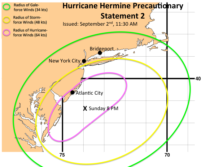
rb924119 wrote:Have a quick second here to post this:
Again, did this for work so PLEASE do not share. My initial thoughts from yesterday's map and brief text about it still look good in my opinion.
Excellent, excellent graphic.
_________________
_______________________________________________________________________________________________________
CLICK HERE to view NJ Strong Snowstorm Classifications
Frank_Wx- Godzilla Seeker
- Posts : 21305
Reputation : 328
Join date : 2013-01-05
Age : 31
Location : Jersey City, NJ -
Re: Hurricane Hermine Discussion
![]() by aiannone Fri Sep 02, 2016 12:04 pm
by aiannone Fri Sep 02, 2016 12:04 pm
Look at how much the wind field expands!!
_________________
-Alex Iannone-

aiannone- Senior Enthusiast - Mod

- Posts : 4814
Reputation : 92
Join date : 2013-01-07
Location : Saint James, LI (Northwest Suffolk Co.)
Re: Hurricane Hermine Discussion
![]() by Quietace Fri Sep 02, 2016 12:05 pm
by Quietace Fri Sep 02, 2016 12:05 pm
I am going to assume that the x is the location of the center of the system. If that the case, given guidance intensity + intensification of the system moving into the Monday time frame; I would figure hurricane force gales would expand further out from the eye than that pole ward. Otherwise I like it.rb924119 wrote:Have a quick second here to post this:
Again, did this for work so PLEASE do not share. My initial thoughts from yesterday's map and brief text about it still look good in my opinion.

Quietace- Meteorologist - Mod
- Posts : 3687
Reputation : 33
Join date : 2013-01-07
Age : 27
Location : Point Pleasant, NJ
Re: Hurricane Hermine Discussion
![]() by jake732 Fri Sep 02, 2016 12:06 pm
by jake732 Fri Sep 02, 2016 12:06 pm

jake732- Pro Enthusiast

- Posts : 449
Reputation : 0
Join date : 2016-01-03
Location : lakewood, nj -
jake732- Pro Enthusiast
- Posts : 449
Reputation : 0
Join date : 2016-01-03
Location : lakewood, nj -
Re: Hurricane Hermine Discussion
![]() by rb924119 Fri Sep 02, 2016 12:26 pm
by rb924119 Fri Sep 02, 2016 12:26 pm
Quietace wrote:I am going to assume that the x is the location of the center of the system. If that the case, given guidance intensity + intensification of the system moving into the Monday time frame; I would figure hurricane force gales would expand further out from the eye than that pole ward. Otherwise I like it.rb924119 wrote:Have a quick second here to post this:
Again, did this for work so PLEASE do not share. My initial thoughts from yesterday's map and brief text about it still look good in my opinion.
Thanks, Frank!!
Ace, yes, that is a correct assumption. The wind field absolutely could expand further than that. That's one of the variables at play, unfortunately, and will depend entirely on how much of a transition this system will be able to make from tropical to non, and in what part of it's secondary life-cycle (strengthening, maturity, or declining). At this time, with the setup that I am seeing, I would not be surprised to see it remain mostly tropical for a longer period of time, which directly impacts the wind field. If it remains tropical (or mostly) and strengthens, which is what I'm hedging my bets toward at this time, it will help to limit the expanse of the field away from the center. When it finally does start transitioning (and what I'm assuming to be at max intensity then beginning to weaken), that field will rapidly expand. However, it looks like it will make the majority of that transition AFTER it reaches its peak intensity, at least in my opinion, which means that as it transitions and that wind field expands (in coordination with the precipitation field), they will both also weaken as they spread out. Fracture. I could be wrong, but that's just my thought at this time. Obviously it's an evolving situation haha
rb924119- Meteorologist
- Posts : 6890
Reputation : 194
Join date : 2013-02-06
Age : 32
Location : Greentown, Pa
Re: Hurricane Hermine Discussion
![]() by Frank_Wx Fri Sep 02, 2016 12:26 pm
by Frank_Wx Fri Sep 02, 2016 12:26 pm
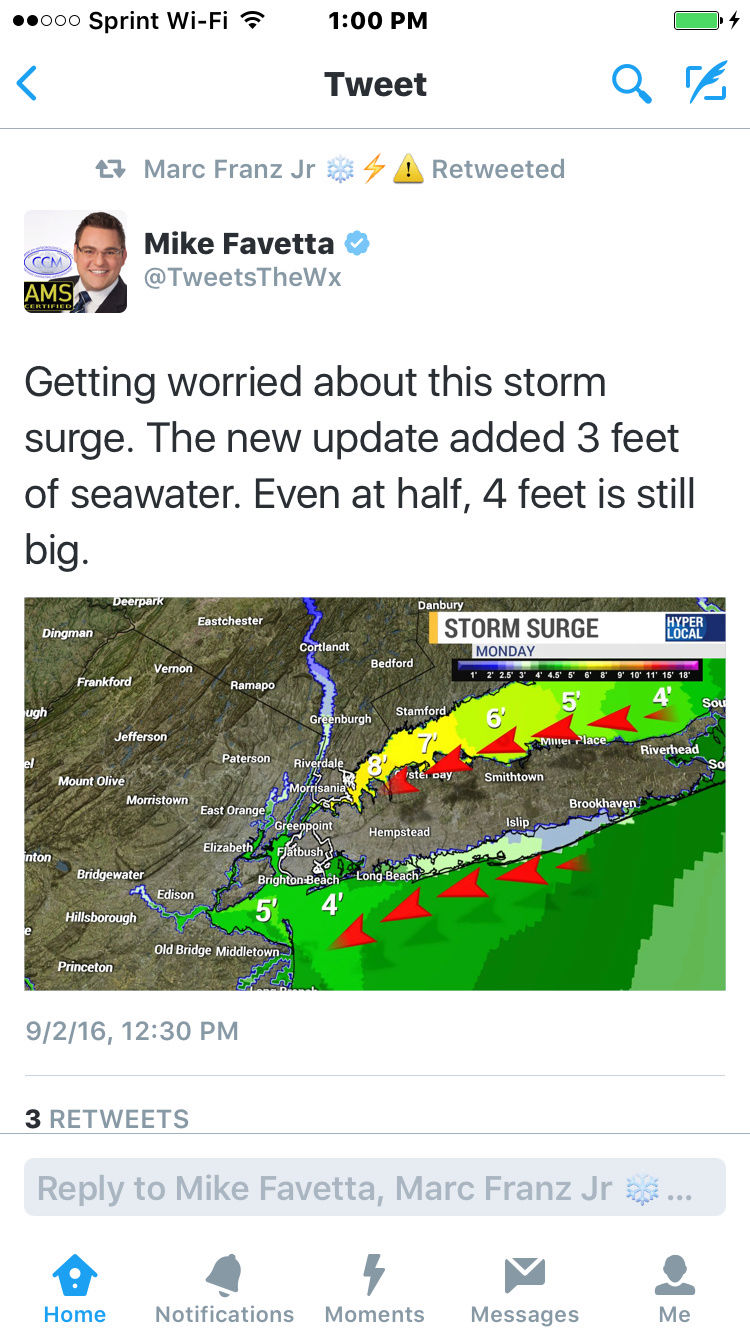
Storm surge could be 3-6 feet based off the 06z GFS.

_________________
_______________________________________________________________________________________________________
CLICK HERE to view NJ Strong Snowstorm Classifications
Frank_Wx- Godzilla Seeker
- Posts : 21305
Reputation : 328
Join date : 2013-01-05
Age : 31
Location : Jersey City, NJ -
Re: Hurricane Hermine Discussion
![]() by rb924119 Fri Sep 02, 2016 12:34 pm
by rb924119 Fri Sep 02, 2016 12:34 pm
Frank_Wx wrote:Yes, will try and put one out around 7pm.
Where'd you find that?? lol
rb924119- Meteorologist
- Posts : 6890
Reputation : 194
Join date : 2013-02-06
Age : 32
Location : Greentown, Pa
Re: Hurricane Hermine Discussion
![]() by jake732 Fri Sep 02, 2016 12:42 pm
by jake732 Fri Sep 02, 2016 12:42 pm
jake732- Pro Enthusiast
- Posts : 449
Reputation : 0
Join date : 2016-01-03
Location : lakewood, nj -
Re: Hurricane Hermine Discussion
![]() by Snow88 Fri Sep 02, 2016 12:45 pm
by Snow88 Fri Sep 02, 2016 12:45 pm
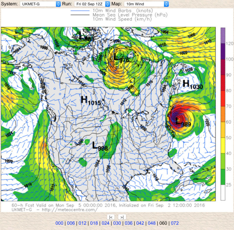
http://meteocentre.com/models/explorateur.php?lang=en&map=na&run=12&mod=ukmet&stn=PNM&comp=1&run2=12&mod2=ukmet&stn2=PNM&hh2=000&fixhh=1&stn2_type=prog&mode=latest&yyyy=latest&mm=latest&dd=latest&hh=072

Snow88- Senior Enthusiast

- Posts : 2193
Reputation : 4
Join date : 2013-01-09
Age : 35
Location : Brooklyn, NY
Re: Hurricane Hermine Discussion
![]() by Snow88 Fri Sep 02, 2016 12:46 pm
by Snow88 Fri Sep 02, 2016 12:46 pm
NWS says NYC beaches will have worst rip tides in over 20 years
Snow88- Senior Enthusiast
- Posts : 2193
Reputation : 4
Join date : 2013-01-09
Age : 35
Location : Brooklyn, NY
Re: Hurricane Hermine Discussion
![]() by SoulSingMG Fri Sep 02, 2016 12:54 pm
by SoulSingMG Fri Sep 02, 2016 12:54 pm
Frank_Wx wrote:Yes, will try and put one out around 7pm.
Storm surge could be 3-6 feet based off the 06z GFS.
Hi everyone! I'm usually pretty quiet during the summer but we've clearly got a situation on our hands.
I also saw this on Twitter and was about to post it; VERY concerning storm surge forecast right now...

SoulSingMG- Senior Enthusiast
- Posts : 2853
Reputation : 74
Join date : 2013-12-11
Location : Long Island City, NY
Re: Hurricane Hermine Discussion
![]() by jmanley32 Fri Sep 02, 2016 1:01 pm
by jmanley32 Fri Sep 02, 2016 1:01 pm
rb924119 wrote:Have a quick second here to post this:
Again, did this for work so PLEASE do not share. My initial thoughts from yesterday's map and brief text about it still look good in my opinion.
Are these sustained? And I imagine with track, these could move further west or east yes? I have been bustin butt at work, and just saw the TS alert on my phone, kinda weird the wording of it as it does not say my city explicitly and says very low winds but maybe that's a preliminary statement as its just a watch. Do you mind if I show your image from here to my family? I won't share it anywhere online.

jmanley32- Senior Enthusiast
- Posts : 20516
Reputation : 108
Join date : 2013-12-12
Age : 42
Location : Yonkers, NY

skinsfan1177- Senior Enthusiast
- Posts : 4485
Reputation : 35
Join date : 2013-01-07
Age : 46
Location : Point Pleasant Boro
Re: Hurricane Hermine Discussion
![]() by rb924119 Fri Sep 02, 2016 1:04 pm
by rb924119 Fri Sep 02, 2016 1:04 pm
Last edited by rb924119 on Fri Sep 02, 2016 1:06 pm; edited 1 time in total
rb924119- Meteorologist
- Posts : 6890
Reputation : 194
Join date : 2013-02-06
Age : 32
Location : Greentown, Pa
Re: Hurricane Hermine Discussion
![]() by SoulSingMG Fri Sep 02, 2016 1:05 pm
by SoulSingMG Fri Sep 02, 2016 1:05 pm
SoulSingMG- Senior Enthusiast
- Posts : 2853
Reputation : 74
Join date : 2013-12-11
Location : Long Island City, NY
Re: Hurricane Hermine Discussion
![]() by jmanley32 Fri Sep 02, 2016 1:06 pm
by jmanley32 Fri Sep 02, 2016 1:06 pm
jmanley32- Senior Enthusiast
- Posts : 20516
Reputation : 108
Join date : 2013-12-12
Age : 42
Location : Yonkers, NY
Re: Hurricane Hermine Discussion
![]() by emokid51783 Fri Sep 02, 2016 1:06 pm
by emokid51783 Fri Sep 02, 2016 1:06 pm
Godspeed all, I'm tracking with nervous eyes as well.
emokid51783- Posts : 144
Reputation : 5
Join date : 2013-12-12
Age : 40
Location : Jersey City Heights, NJ
Re: Hurricane Hermine Discussion
![]() by rb924119 Fri Sep 02, 2016 1:08 pm
by rb924119 Fri Sep 02, 2016 1:08 pm
jmanley32 wrote:rb924119 wrote:Have a quick second here to post this:
Again, did this for work so PLEASE do not share. My initial thoughts from yesterday's map and brief text about it still look good in my opinion.
Are these sustained? And I imagine with track, these could move further west or east yes? I have been bustin butt at work, and just saw the TS alert on my phone, kinda weird the wording of it as it does not say my city explicitly and says very low winds but maybe that's a preliminary statement as its just a watch. Do you mind if I show your image from here to my family? I won't share it anywhere online.
Yeah. Although for the fringe regions, it would be more gusty than sustained because of mixing. But generally, yes, sustained. And no, go right ahead!! That's just a preliminary thought, though, Jman, not set in stone. I just don't want it shared online, that's all lol
rb924119- Meteorologist
- Posts : 6890
Reputation : 194
Join date : 2013-02-06
Age : 32
Location : Greentown, Pa

Snow88- Senior Enthusiast
- Posts : 2193
Reputation : 4
Join date : 2013-01-09
Age : 35
Location : Brooklyn, NY
Re: Hurricane Hermine Discussion
![]() by jmanley32 Fri Sep 02, 2016 1:14 pm
by jmanley32 Fri Sep 02, 2016 1:14 pm
rb924119 wrote:jmanley32 wrote:rb924119 wrote:Have a quick second here to post this:
Again, did this for work so PLEASE do not share. My initial thoughts from yesterday's map and brief text about it still look good in my opinion.
Are these sustained? And I imagine with track, these could move further west or east yes? I have been bustin butt at work, and just saw the TS alert on my phone, kinda weird the wording of it as it does not say my city explicitly and says very low winds but maybe that's a preliminary statement as its just a watch. Do you mind if I show your image from here to my family? I won't share it anywhere online.
Yeah. Although for the fringe regions, it would be more gusty than sustained because of mixing. But generally, yes, sustained. And no, go right ahead!! That's just a preliminary thought, though, Jman, not set in stone. I just don't want it shared online, that's all lol
Well you have me well within the green (spo potentially gusts to 60mph maybe in that area?), and almost yellow, and updated TS watch says to prepare for 39-57kt winds in my area, even inland southern Westchester. Is it possible hurricane watches go up if this intensifies to that amount? Or will it stay far enough off shore> I mean up into NYC, not NJ which appears to have the best chance of that. Guess I should stock up on some stuff maybe tomorrow, or do you think people will start panicking to morrow and stores will b nuts? 4 more model suites....uggg, better not push out anymore. Oh BTW TS watch says about 800 miles south of area so got a bit of a trek lol.
Last edited by jmanley32 on Fri Sep 02, 2016 1:16 pm; edited 1 time in total
jmanley32- Senior Enthusiast
- Posts : 20516
Reputation : 108
Join date : 2013-12-12
Age : 42
Location : Yonkers, NY
Page 32 of 40 • 1 ... 17 ... 31, 32, 33 ... 36 ... 40 ![]()
|
|
|