
 Search
December 2016 Observations & Discussions
Page 5 of 16 •  1, 2, 3, 4, 5, 6 ... 10 ... 16
 ![]()
Re: December 2016 Observations & Discussions
![]() by jake732 Tue Dec 13, 2016 2:15 pm
by jake732 Tue Dec 13, 2016 2:15 pm
READ ABOUT THIS WEEKS COLD AS WELL AS A STORM ON ITS WAY. PLZ SHARE!!
LAKEWOOD WEATHER: SATURDAY DECEMBER 17TH http://lakewood732weather.blogspot.com/2016/12/saturday-december-17th.html?spref=tw …
jake732- Pro Enthusiast

- Posts : 449
Join date : 2016-01-03 -

Re: December 2016 Observations & Discussions
![]() by HectorO Tue Dec 13, 2016 3:50 pm
by HectorO Tue Dec 13, 2016 3:50 pm
HectorO- Pro Enthusiast
- Posts : 959
Join date : 2013-01-11
Re: December 2016 Observations & Discussions
![]() by CPcantmeasuresnow Tue Dec 13, 2016 4:46 pm
by CPcantmeasuresnow Tue Dec 13, 2016 4:46 pm
Frank_Wx wrote:Today's model continue showing a snow, ice, and rain threat for Saturday. At this time, I am thinking 2 to 4 inches of snow will accumulation for much of the area Saturday morning (beginning around 4am). It will change to a mix or freezing rain later Saturday morning then a plain rain by Saurday afternoon. The timing is still uncertain and exactly how much snow falls before the changeover is also iffy. GFS shows 3 to 6 inches while EURO is less bullish.
Either way, a storm is coming on Saturday. Clouds and rain will linger into all day Sunday. A miserable weekend ahead.
Still much better than last December, at least IMO.

CPcantmeasuresnow- Wx Statistician Guru

- Posts : 7274
Reputation : 230
Join date : 2013-01-07
Age : 103
Location : Eastern Orange County, NY
Re: December 2016 Observations & Discussions
![]() by aiannone Tue Dec 13, 2016 8:48 pm
by aiannone Tue Dec 13, 2016 8:48 pm
_________________
-Alex Iannone-

aiannone- Senior Enthusiast - Mod

- Posts : 4813
Reputation : 92
Join date : 2013-01-07
Location : Saint James, LI (Northwest Suffolk Co.)
Re: December 2016 Observations & Discussions
![]() by Frank_Wx Tue Dec 13, 2016 10:39 pm
by Frank_Wx Tue Dec 13, 2016 10:39 pm

_________________
_______________________________________________________________________________________________________
CLICK HERE to view NJ Strong Snowstorm Classifications

Frank_Wx- Godzilla Seeker

- Posts : 21305
Reputation : 328
Join date : 2013-01-05
Age : 31
Location : Jersey City, NJ -
Re: December 2016 Observations & Discussions
![]() by Frank_Wx Tue Dec 13, 2016 10:41 pm
by Frank_Wx Tue Dec 13, 2016 10:41 pm
_________________
_______________________________________________________________________________________________________
CLICK HERE to view NJ Strong Snowstorm Classifications
Frank_Wx- Godzilla Seeker
- Posts : 21305
Reputation : 328
Join date : 2013-01-05
Age : 31
Location : Jersey City, NJ -
Re: December 2016 Observations & Discussions
![]() by Frank_Wx Tue Dec 13, 2016 10:45 pm
by Frank_Wx Tue Dec 13, 2016 10:45 pm

_________________
_______________________________________________________________________________________________________
CLICK HERE to view NJ Strong Snowstorm Classifications
Frank_Wx- Godzilla Seeker
- Posts : 21305
Reputation : 328
Join date : 2013-01-05
Age : 31
Location : Jersey City, NJ -
Re: December 2016 Observations & Discussions
![]() by weatherwatchermom Tue Dec 13, 2016 10:56 pm
by weatherwatchermom Tue Dec 13, 2016 10:56 pm
Looks like a homemade bread and big pot of soup day!!Frank_Wx wrote:NW winds on Thursday look pretty gusty too. Gusts could surpass 30mph, especially along the coast. Coupled with the wind chills in the single digits and the snow squalls, it's going to be quite a day.

weatherwatchermom- Senior Enthusiast

- Posts : 3734
Reputation : 77
Join date : 2014-11-25
Age : 60
Location : Hazlet Township, NJ
Re: December 2016 Observations & Discussions
![]() by Frank_Wx Tue Dec 13, 2016 11:07 pm
by Frank_Wx Tue Dec 13, 2016 11:07 pm
_________________
_______________________________________________________________________________________________________
CLICK HERE to view NJ Strong Snowstorm Classifications
Frank_Wx- Godzilla Seeker
- Posts : 21305
Reputation : 328
Join date : 2013-01-05
Age : 31
Location : Jersey City, NJ -
Re: December 2016 Observations & Discussions
![]() by jmanley32 Wed Dec 14, 2016 3:28 pm
by jmanley32 Wed Dec 14, 2016 3:28 pm
/O.NEW.KOKX.WI.Y.0008.161215T1400Z-161215T2300Z/
/O.NEW.KOKX.HW.A.0002.161215T2300Z-161216T1100Z/
NORTHERN FAIRFIELD-NORTHERN NEW HAVEN-NORTHERN MIDDLESEX-
NORTHERN NEW LONDON-SOUTHERN FAIRFIELD-SOUTHERN NEW HAVEN-
SOUTHERN MIDDLESEX-SOUTHERN NEW LONDON-WESTERN PASSAIC-
EASTERN PASSAIC-HUDSON-WESTERN BERGEN-EASTERN BERGEN-
WESTERN ESSEX-EASTERN ESSEX-WESTERN UNION-EASTERN UNION-ORANGE-
PUTNAM-ROCKLAND-NORTHERN WESTCHESTER-SOUTHERN WESTCHESTER-
NEW YORK (MANHATTAN)-BRONX-RICHMOND (STATEN ISLAND)-
KINGS (BROOKLYN)-NORTHWESTERN SUFFOLK-NORTHEASTERN SUFFOLK-
SOUTHWESTERN SUFFOLK-SOUTHEASTERN SUFFOLK-NORTHERN QUEENS-
NORTHERN NASSAU-SOUTHERN QUEENS-SOUTHERN NASSAU-
320 PM EST WED DEC 14 2016
...WIND ADVISORY IN EFFECT FROM 9 AM TO 6 PM EST THURSDAY...
...HIGH WIND WATCH IN EFFECT FROM THURSDAY EVENING THROUGH LATE
THURSDAY NIGHT...
THE NATIONAL WEATHER SERVICE IN UPTON HAS ISSUED A WIND
ADVISORY...WHICH IS IN EFFECT FROM 9 AM TO 6 PM EST THURSDAY. A
HIGH WIND WATCH HAS ALSO BEEN ISSUED. THIS HIGH WIND WATCH IS IN
EFFECT FROM THURSDAY EVENING THROUGH LATE THURSDAY NIGHT.
* WINDS...NORTHWEST 20 TO 35 MPH WITH GUSTS UP TO 50 MPH DURING
THE DAY, AND 60 MPH AT NIGHT.
* TIMING...HIGHEST WIND POTENTIAL THURSDAY NIGHT.
* IMPACTS...POSSIBLE DAMAGING WINDS MAY BLOW DOWN TREES AND POWER
LINES. WIDESPREAD POWER OUTAGES ARE POSSIBLE. TRAVEL WILL BE
DIFFICULT...ESPECIALLY FOR HIGH PROFILE VEHICLES.

jmanley32- Senior Enthusiast
- Posts : 20513
Reputation : 108
Join date : 2013-12-12
Age : 42
Location : Yonkers, NY
Re: December 2016 Observations & Discussions
![]() by jmanley32 Wed Dec 14, 2016 3:30 pm
by jmanley32 Wed Dec 14, 2016 3:30 pm
jmanley32- Senior Enthusiast
- Posts : 20513
Reputation : 108
Join date : 2013-12-12
Age : 42
Location : Yonkers, NY
Re: December 2016 Observations & Discussions
![]() by SoulSingMG Wed Dec 14, 2016 3:30 pm
by SoulSingMG Wed Dec 14, 2016 3:30 pm
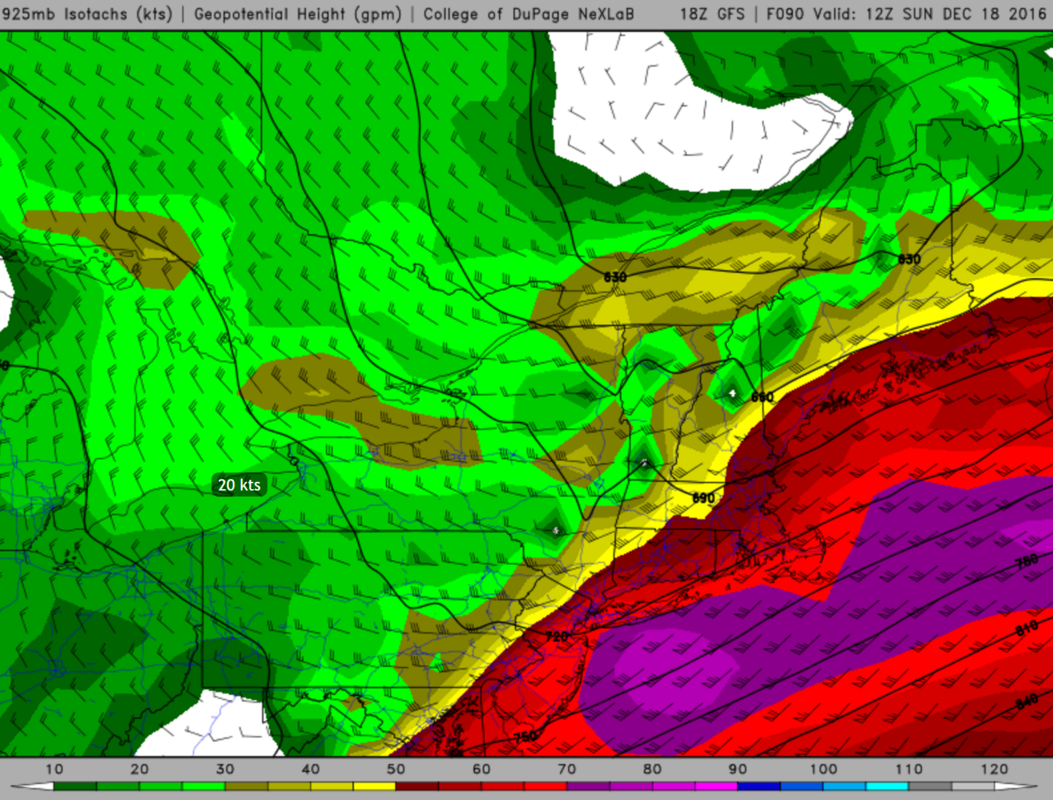
jmanley32 wrote:Winds might be quite a bit higher than you expected Frank, just issues for my area and pts east (It looks like Fri the 925mb winds are quite high too pushing 50-70mph?
/O.NEW.KOKX.WI.Y.0008.161215T1400Z-161215T2300Z/
/O.NEW.KOKX.HW.A.0002.161215T2300Z-161216T1100Z/
NORTHERN FAIRFIELD-NORTHERN NEW HAVEN-NORTHERN MIDDLESEX-
NORTHERN NEW LONDON-SOUTHERN FAIRFIELD-SOUTHERN NEW HAVEN-
SOUTHERN MIDDLESEX-SOUTHERN NEW LONDON-WESTERN PASSAIC-
EASTERN PASSAIC-HUDSON-WESTERN BERGEN-EASTERN BERGEN-
WESTERN ESSEX-EASTERN ESSEX-WESTERN UNION-EASTERN UNION-ORANGE-
PUTNAM-ROCKLAND-NORTHERN WESTCHESTER-SOUTHERN WESTCHESTER-
NEW YORK (MANHATTAN)-BRONX-RICHMOND (STATEN ISLAND)-
KINGS (BROOKLYN)-NORTHWESTERN SUFFOLK-NORTHEASTERN SUFFOLK-
SOUTHWESTERN SUFFOLK-SOUTHEASTERN SUFFOLK-NORTHERN QUEENS-
NORTHERN NASSAU-SOUTHERN QUEENS-SOUTHERN NASSAU-
320 PM EST WED DEC 14 2016
...WIND ADVISORY IN EFFECT FROM 9 AM TO 6 PM EST THURSDAY...
...HIGH WIND WATCH IN EFFECT FROM THURSDAY EVENING THROUGH LATE
THURSDAY NIGHT...
THE NATIONAL WEATHER SERVICE IN UPTON HAS ISSUED A WIND
ADVISORY...WHICH IS IN EFFECT FROM 9 AM TO 6 PM EST THURSDAY. A
HIGH WIND WATCH HAS ALSO BEEN ISSUED. THIS HIGH WIND WATCH IS IN
EFFECT FROM THURSDAY EVENING THROUGH LATE THURSDAY NIGHT.
* WINDS...NORTHWEST 20 TO 35 MPH WITH GUSTS UP TO 50 MPH DURING
THE DAY, AND 60 MPH AT NIGHT.
* TIMING...HIGHEST WIND POTENTIAL THURSDAY NIGHT.
* IMPACTS...POSSIBLE DAMAGING WINDS MAY BLOW DOWN TREES AND POWER
LINES. WIDESPREAD POWER OUTAGES ARE POSSIBLE. TRAVEL WILL BE
DIFFICULT...ESPECIALLY FOR HIGH PROFILE VEHICLES.
WOW, was just about to post this Jman! Taunton went wild too with their afternoon advisories. We're in for a bumpy ride.

SoulSingMG- Senior Enthusiast
- Posts : 2853
Reputation : 74
Join date : 2013-12-11
Location : Long Island City, NY
Re: December 2016 Observations & Discussions
![]() by jmanley32 Wed Dec 14, 2016 3:34 pm
by jmanley32 Wed Dec 14, 2016 3:34 pm
SoulSingMG wrote:jmanley32 wrote:Winds might be quite a bit higher than you expected Frank, just issues for my area and pts east (It looks like Fri the 925mb winds are quite high too pushing 50-70mph?
/O.NEW.KOKX.WI.Y.0008.161215T1400Z-161215T2300Z/
/O.NEW.KOKX.HW.A.0002.161215T2300Z-161216T1100Z/
NORTHERN FAIRFIELD-NORTHERN NEW HAVEN-NORTHERN MIDDLESEX-
NORTHERN NEW LONDON-SOUTHERN FAIRFIELD-SOUTHERN NEW HAVEN-
SOUTHERN MIDDLESEX-SOUTHERN NEW LONDON-WESTERN PASSAIC-
EASTERN PASSAIC-HUDSON-WESTERN BERGEN-EASTERN BERGEN-
WESTERN ESSEX-EASTERN ESSEX-WESTERN UNION-EASTERN UNION-ORANGE-
PUTNAM-ROCKLAND-NORTHERN WESTCHESTER-SOUTHERN WESTCHESTER-
NEW YORK (MANHATTAN)-BRONX-RICHMOND (STATEN ISLAND)-
KINGS (BROOKLYN)-NORTHWESTERN SUFFOLK-NORTHEASTERN SUFFOLK-
SOUTHWESTERN SUFFOLK-SOUTHEASTERN SUFFOLK-NORTHERN QUEENS-
NORTHERN NASSAU-SOUTHERN QUEENS-SOUTHERN NASSAU-
320 PM EST WED DEC 14 2016
...WIND ADVISORY IN EFFECT FROM 9 AM TO 6 PM EST THURSDAY...
...HIGH WIND WATCH IN EFFECT FROM THURSDAY EVENING THROUGH LATE
THURSDAY NIGHT...
THE NATIONAL WEATHER SERVICE IN UPTON HAS ISSUED A WIND
ADVISORY...WHICH IS IN EFFECT FROM 9 AM TO 6 PM EST THURSDAY. A
HIGH WIND WATCH HAS ALSO BEEN ISSUED. THIS HIGH WIND WATCH IS IN
EFFECT FROM THURSDAY EVENING THROUGH LATE THURSDAY NIGHT.
* WINDS...NORTHWEST 20 TO 35 MPH WITH GUSTS UP TO 50 MPH DURING
THE DAY, AND 60 MPH AT NIGHT.
* TIMING...HIGHEST WIND POTENTIAL THURSDAY NIGHT.
* IMPACTS...POSSIBLE DAMAGING WINDS MAY BLOW DOWN TREES AND POWER
LINES. WIDESPREAD POWER OUTAGES ARE POSSIBLE. TRAVEL WILL BE
DIFFICULT...ESPECIALLY FOR HIGH PROFILE VEHICLES.
WOW, was just about to post this Jman! Taunton went wild too with their afternoon advisories. We're in for a bumpy ride.
Even with the advisories and watch these wind events as we know can bust easily, but with such a cold airmass coming in screeching I can see this verifying. That means tomorrow and into Fri morning we could see low single digit windchills, and if we hit or top 60mph gusts could have some tree damage. at least there are no leaves on the trees.
jmanley32- Senior Enthusiast
- Posts : 20513
Reputation : 108
Join date : 2013-12-12
Age : 42
Location : Yonkers, NY
Re: December 2016 Observations & Discussions
![]() by jmanley32 Wed Dec 14, 2016 3:36 pm
by jmanley32 Wed Dec 14, 2016 3:36 pm
jmanley32- Senior Enthusiast
- Posts : 20513
Reputation : 108
Join date : 2013-12-12
Age : 42
Location : Yonkers, NY
Re: December 2016 Observations & Discussions
![]() by jmanley32 Wed Dec 14, 2016 3:41 pm
by jmanley32 Wed Dec 14, 2016 3:41 pm
/O.NEW.KBOX.HW.A.0006.161215T2300Z-161216T0900Z/
BARNSTABLE MA-DUKES MA-NANTUCKET MA-BLOCK ISLAND RI-
INCLUDING THE CITIES OF...CHATHAM...FALMOUTH...PROVINCETOWN...
VINEYARD HAVEN...NANTUCKET...BLOCK ISLAND
258 PM EST WED DEC 14 2016
...HIGH WIND WATCH IN EFFECT FROM THURSDAY EVENING THROUGH LATE
THURSDAY NIGHT...
THE NATIONAL WEATHER SERVICE IN TAUNTON HAS ISSUED A HIGH WIND
WATCH...WHICH IS IN EFFECT FROM THURSDAY EVENING THROUGH LATE
THURSDAY NIGHT.
* LOCATION...CAPE COD AND THE ISLANDS.
* WINDS...WEST 30 TO 40 MPH WITH POSSIBLE GUSTS UP TO 70 MPH.
* TIMING...STRONGEST WINDS ARE EXPECTED BETWEEN 8 PM THURSDAY AND
4 AM FRIDAY.
jmanley32- Senior Enthusiast
- Posts : 20513
Reputation : 108
Join date : 2013-12-12
Age : 42
Location : Yonkers, NY
Re: December 2016 Observations & Discussions
![]() by skinsfan1177 Wed Dec 14, 2016 4:30 pm
by skinsfan1177 Wed Dec 14, 2016 4:30 pm
jmanley32 wrote:I know not our area but dayumm...
/O.NEW.KBOX.HW.A.0006.161215T2300Z-161216T0900Z/
BARNSTABLE MA-DUKES MA-NANTUCKET MA-BLOCK ISLAND RI-
INCLUDING THE CITIES OF...CHATHAM...FALMOUTH...PROVINCETOWN...
VINEYARD HAVEN...NANTUCKET...BLOCK ISLAND
258 PM EST WED DEC 14 2016
...HIGH WIND WATCH IN EFFECT FROM THURSDAY EVENING THROUGH LATE
THURSDAY NIGHT...
THE NATIONAL WEATHER SERVICE IN TAUNTON HAS ISSUED A HIGH WIND
WATCH...WHICH IS IN EFFECT FROM THURSDAY EVENING THROUGH LATE
THURSDAY NIGHT.
* LOCATION...CAPE COD AND THE ISLANDS.
* WINDS...WEST 30 TO 40 MPH WITH POSSIBLE GUSTS UP TO 70 MPH.
* TIMING...STRONGEST WINDS ARE EXPECTED BETWEEN 8 PM THURSDAY AND
4 AM FRIDAY.
Jman do you have wind info for my area

skinsfan1177- Senior Enthusiast
- Posts : 4485
Reputation : 35
Join date : 2013-01-07
Age : 46
Location : Point Pleasant Boro
Re: December 2016 Observations & Discussions
![]() by Frank_Wx Wed Dec 14, 2016 5:40 pm
by Frank_Wx Wed Dec 14, 2016 5:40 pm
_________________
_______________________________________________________________________________________________________
CLICK HERE to view NJ Strong Snowstorm Classifications
Frank_Wx- Godzilla Seeker
- Posts : 21305
Reputation : 328
Join date : 2013-01-05
Age : 31
Location : Jersey City, NJ -
Re: December 2016 Observations & Discussions
![]() by jmanley32 Wed Dec 14, 2016 5:57 pm
by jmanley32 Wed Dec 14, 2016 5:57 pm
Frank_Wx wrote:I think winds will be stronger on Sunday. I think tomorrow there will be gusts in the 35-45mph range. Nothing too special. Sunday they could gust over 50mph. 925mb winds are shown to be between 60 and 70kts. At the surface that is 55 to 65 mph winds. This is due to a front coming through the area. Southerly winds ahead of it, strong north westerlies behind it.
I actually agree, had no idea there was even a wind threat tomorrow, NWS is bullish, the models have been show very high gusts for sunday, those 925mb winds are sustained so are we talking 40+ sustained?!. We will see what happens.
jmanley32- Senior Enthusiast
- Posts : 20513
Reputation : 108
Join date : 2013-12-12
Age : 42
Location : Yonkers, NY
Re: December 2016 Observations & Discussions
![]() by skinsfan1177 Wed Dec 14, 2016 7:42 pm
by skinsfan1177 Wed Dec 14, 2016 7:42 pm
skinsfan1177- Senior Enthusiast
- Posts : 4485
Reputation : 35
Join date : 2013-01-07
Age : 46
Location : Point Pleasant Boro
Re: December 2016 Observations & Discussions
![]() by Frank_Wx Wed Dec 14, 2016 8:14 pm
by Frank_Wx Wed Dec 14, 2016 8:14 pm
skinsfan1177 wrote:So when does this front come through tommorrow with possible snow squalls
Tomorrow is not really a front. More like upper level energy swinging through the area from the Polar Vortex. Gusty winds and scattered snow squalls throughout the entire day.
_________________
_______________________________________________________________________________________________________
CLICK HERE to view NJ Strong Snowstorm Classifications
Frank_Wx- Godzilla Seeker
- Posts : 21305
Reputation : 328
Join date : 2013-01-05
Age : 31
Location : Jersey City, NJ -
Re: December 2016 Observations & Discussions
![]() by skinsfan1177 Wed Dec 14, 2016 8:32 pm
by skinsfan1177 Wed Dec 14, 2016 8:32 pm
Frank_Wx wrote:skinsfan1177 wrote:So when does this front come through tommorrow with possible snow squalls
Tomorrow is not really a front. More like upper level energy swinging through the area from the Polar Vortex. Gusty winds and scattered snow squalls throughout the entire day.
Thanks frank
skinsfan1177- Senior Enthusiast
- Posts : 4485
Reputation : 35
Join date : 2013-01-07
Age : 46
Location : Point Pleasant Boro
Re: December 2016 Observations & Discussions
![]() by dkodgis Thu Dec 15, 2016 4:24 am
by dkodgis Thu Dec 15, 2016 4:24 am

dkodgis- Senior Enthusiast
- Posts : 2493
Reputation : 98
Join date : 2013-12-29
Re: December 2016 Observations & Discussions
![]() by jmanley32 Thu Dec 15, 2016 4:43 am
by jmanley32 Thu Dec 15, 2016 4:43 am
jmanley32- Senior Enthusiast
- Posts : 20513
Reputation : 108
Join date : 2013-12-12
Age : 42
Location : Yonkers, NY
Re: December 2016 Observations & Discussions
![]() by skinsfan1177 Thu Dec 15, 2016 5:09 am
by skinsfan1177 Thu Dec 15, 2016 5:09 am
skinsfan1177- Senior Enthusiast
- Posts : 4485
Reputation : 35
Join date : 2013-01-07
Age : 46
Location : Point Pleasant Boro
Re: December 2016 Observations & Discussions
![]() by frank 638 Thu Dec 15, 2016 5:20 am
by frank 638 Thu Dec 15, 2016 5:20 am
frank 638- Senior Enthusiast
- Posts : 2824
Reputation : 37
Join date : 2016-01-01
Age : 40
Location : bronx ny
Re: December 2016 Observations & Discussions
![]() by weatherwatchermom Thu Dec 15, 2016 6:34 am
by weatherwatchermom Thu Dec 15, 2016 6:34 am
weatherwatchermom- Senior Enthusiast
- Posts : 3734
Reputation : 77
Join date : 2014-11-25
Age : 60
Location : Hazlet Township, NJ
Re: December 2016 Observations & Discussions
![]() by Dtone Thu Dec 15, 2016 6:52 am
by Dtone Thu Dec 15, 2016 6:52 am
29*
Dtone- Wx Statistician Guru
- Posts : 1738
Reputation : 9
Join date : 2013-08-26
Location : Bronx, NY
Page 5 of 16 • 1, 2, 3, 4, 5, 6 ... 10 ... 16 ![]()
|
|
|