
 Search
January 2017 Observations & Discussions
Page 6 of 13 •  1, 2, 3 ... 5, 6, 7 ... 11, 12, 13
 ![]()
Re: January 2017 Observations & Discussions
![]() by skinsfan1177 Thu Jan 12, 2017 3:04 pm
by skinsfan1177 Thu Jan 12, 2017 3:04 pm
skinsfan1177- Senior Enthusiast

- Posts : 4485
Join date : 2013-01-07
Re: January 2017 Observations & Discussions
![]() by docstox12 Thu Jan 12, 2017 3:25 pm
by docstox12 Thu Jan 12, 2017 3:25 pm
docstox12- Wx Statistician Guru

- Posts : 8502
Join date : 2013-01-07
Re: January 2017 Observations & Discussions
![]() by skinsfan1177 Thu Jan 12, 2017 3:30 pm
by skinsfan1177 Thu Jan 12, 2017 3:30 pm

skinsfan1177- Senior Enthusiast
- Posts : 4485
Reputation : 35
Join date : 2013-01-07
Age : 46
Location : Point Pleasant Boro
Re: January 2017 Observations & Discussions
![]() by frank 638 Thu Jan 12, 2017 3:54 pm
by frank 638 Thu Jan 12, 2017 3:54 pm
frank 638- Senior Enthusiast
- Posts : 2824
Reputation : 37
Join date : 2016-01-01
Age : 40
Location : bronx ny
Re: January 2017 Observations & Discussions
![]() by HectorO Thu Jan 12, 2017 4:42 pm
by HectorO Thu Jan 12, 2017 4:42 pm

HectorO- Pro Enthusiast

- Posts : 959
Reputation : 27
Join date : 2013-01-11
Re: January 2017 Observations & Discussions
![]() by weatherwatchermom Thu Jan 12, 2017 4:52 pm
by weatherwatchermom Thu Jan 12, 2017 4:52 pm

weatherwatchermom- Senior Enthusiast
- Posts : 3734
Reputation : 77
Join date : 2014-11-25
Age : 60
Location : Hazlet Township, NJ
Re: January 2017 Observations & Discussions
![]() by Isotherm Thu Jan 12, 2017 8:40 pm
by Isotherm Thu Jan 12, 2017 8:40 pm
Hit 69.3F. Very impressive. Surges me to +2.2 for January.
Could see another sneaky anomalous positive day with a midnight high. Still mid 60s across most of the area.
Isotherm- Advanced Forecaster

- Posts : 231
Reputation : 4
Join date : 2014-09-01
Age : 33
Location : Monmouth County, NJ -

Re: January 2017 Observations & Discussions
![]() by skinsfan1177 Fri Jan 13, 2017 7:20 am
by skinsfan1177 Fri Jan 13, 2017 7:20 am
skinsfan1177- Senior Enthusiast
- Posts : 4485
Reputation : 35
Join date : 2013-01-07
Age : 46
Location : Point Pleasant Boro
Re: January 2017 Observations & Discussions
![]() by CPcantmeasuresnow Fri Jan 13, 2017 9:05 am
by CPcantmeasuresnow Fri Jan 13, 2017 9:05 am
Central Park and JFK now 2.8 degrees above normal for the month, LGA 3.9 above.
This month may actually approach a plus 5, IMO anything above a plus 2 is tough to deal with. Hopefully February makes up for it as our experts seem to be hinting could happen.

CPcantmeasuresnow- Wx Statistician Guru
- Posts : 7274
Reputation : 230
Join date : 2013-01-07
Age : 103
Location : Eastern Orange County, NY
Re: January 2017 Observations & Discussions
![]() by Dtone Fri Jan 13, 2017 11:14 am
by Dtone Fri Jan 13, 2017 11:14 am
skinsfan1177 wrote:Does anyone know if records where broke yesterday
Central Park 66 (old record 64)
LGA 68 (60)
JFK 61 (60)
Bridgeport 55 (52)
Newark 67 (61)
Record high low temps:
Central Park 47 (old record 46)
LGA 48 (46)
JFK 46 (44)
EWR 46 (43)
BDR 42 (41)
ISP 47 (42)
Records up and down I-95. low 60s around Bos to low 70s around DC.
Dtone- Wx Statistician Guru
- Posts : 1738
Reputation : 9
Join date : 2013-08-26
Location : Bronx, NY
Re: January 2017 Observations & Discussions
![]() by docstox12 Fri Jan 13, 2017 12:32 pm
by docstox12 Fri Jan 13, 2017 12:32 pm
38.4, 70%, 30.16 R
Winds are really howling up here.Would be nice to see a few flakes tomorrow but it looks like this storm is suppressed to my south.THERE'S something new and different,LOL. Might be the last flakes for a week or so.

docstox12- Wx Statistician Guru
- Posts : 8502
Reputation : 222
Join date : 2013-01-07
Age : 73
Location : Monroe NY
Re: January 2017 Observations & Discussions
![]() by CPcantmeasuresnow Sat Jan 14, 2017 9:27 am
by CPcantmeasuresnow Sat Jan 14, 2017 9:27 am
I revise what I said yesterday and say this month will definitely be a plus 5 for temperatures at every Upton reporting location.
Actually with the next two days near normal and the ten days afterward now looking to be 10-15 above normal we may be looking at a top 10 warmest January when all is said and done. That will probably depend on whether or not we get the hoped for pattern change before the month ends.
CPcantmeasuresnow- Wx Statistician Guru
- Posts : 7274
Reputation : 230
Join date : 2013-01-07
Age : 103
Location : Eastern Orange County, NY
Re: January 2017 Observations & Discussions
![]() by weatherwatchermom Sun Jan 15, 2017 9:20 am
by weatherwatchermom Sun Jan 15, 2017 9:20 am
weatherwatchermom- Senior Enthusiast
- Posts : 3734
Reputation : 77
Join date : 2014-11-25
Age : 60
Location : Hazlet Township, NJ
Re: January 2017 Observations & Discussions
![]() by Frank_Wx Sun Jan 15, 2017 10:28 am
by Frank_Wx Sun Jan 15, 2017 10:28 am
CPcantmeasuresnow wrote:Central Park and JFK now 3.7 degrees above normal for the month, LGA 4.8 above.
I revise what I said yesterday and say this month will definitely be a plus 5 for temperatures at every Upton reporting location.
Actually with the next two days near normal and the ten days afterward now looking to be 10-15 above normal we may be looking at a top 10 warmest January when all is said and done. That will probably depend on whether or not we get the hoped for pattern change before the month ends.
Agree completely
_________________
_______________________________________________________________________________________________________
CLICK HERE to view NJ Strong Snowstorm Classifications

Frank_Wx- Godzilla Seeker

- Posts : 21305
Reputation : 328
Join date : 2013-01-05
Age : 31
Location : Jersey City, NJ -
Re: January 2017 Observations & Discussions
![]() by Frank_Wx Sun Jan 15, 2017 10:38 am
by Frank_Wx Sun Jan 15, 2017 10:38 am
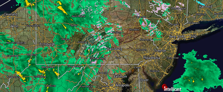
Here's the 500mb upper air pattern next 7 to 10 days. Horrific.

_________________
_______________________________________________________________________________________________________
CLICK HERE to view NJ Strong Snowstorm Classifications
Frank_Wx- Godzilla Seeker
- Posts : 21305
Reputation : 328
Join date : 2013-01-05
Age : 31
Location : Jersey City, NJ -
Re: January 2017 Observations & Discussions
![]() by billg315 Sun Jan 15, 2017 12:32 pm
by billg315 Sun Jan 15, 2017 12:32 pm

billg315- Advanced Forecaster - Mod

- Posts : 4462
Reputation : 185
Join date : 2015-01-24
Age : 50
Location : Flemington, NJ
Re: January 2017 Observations & Discussions
![]() by Guest Sun Jan 15, 2017 3:56 pm
by Guest Sun Jan 15, 2017 3:56 pm
Guest- Guest
Re: January 2017 Observations & Discussions
![]() by algae888 Sun Jan 15, 2017 8:23 pm
by algae888 Sun Jan 15, 2017 8:23 pm
When it's active weather is fun esp in winter and snow will fall with + departures. Some trend good some bad but its the tracking thats fun. I could care less about temps just bring s/w through and It will snow in the north east in heart of winter. Yea 30" + is def possible from jfk east. Very unlikely at cpk as totals will be underestimated. 1"yesterday 11" for season. Will take this any year with snowiest climo upcomingsyosnow94 wrote:I may need to change my thinking. With 2 full months of winter left most areas on LI are between 18-20" of snow so far in 1 months time. It feels like A crap winter so far because it's been so warm and the snow has only stuck around for a total of 4 days but.......if we keep going at this rate it would result in 55-60" One can only hope.

algae888- Advanced Forecaster
- Posts : 5311
Reputation : 46
Join date : 2013-02-05
Age : 61
Location : mt. vernon, new york
Re: January 2017 Observations & Discussions
![]() by algae888 Sun Jan 15, 2017 8:29 pm
by algae888 Sun Jan 15, 2017 8:29 pm
algae888- Advanced Forecaster
- Posts : 5311
Reputation : 46
Join date : 2013-02-05
Age : 61
Location : mt. vernon, new york
Re: January 2017 Observations & Discussions
![]() by sroc4 Sun Jan 15, 2017 8:37 pm
by sroc4 Sun Jan 15, 2017 8:37 pm
syosnow94 wrote:I may need to change my thinking. With 2 full months of winter left most areas on LI are between 18-20" of snow so far in 1 months time. It feels like A crap winter so far because it's been so warm and the snow has only stuck around for a total of 4 days but.......if we keep going at this rate it would result in 55-60" One can only hope.
Atta boy Jimmy. Welcome to the glass half full
_________________
"In weather and in life, there's no winning and losing; there's only winning and learning."
WINTER 2012/2013 TOTALS 43.65"WINTER 2017/2018 TOTALS 62.85" WINTER 2022/2023 TOTALS 4.9"
WINTER 2013/2014 TOTALS 64.85"WINTER 2018/2019 TOTALS 14.25" WINTER 2023/2024 TOTALS 13.1"
WINTER 2014/2015 TOTALS 71.20"WINTER 2019/2020 TOTALS 6.35"
WINTER 2015/2016 TOTALS 35.00"WINTER 2020/2021 TOTALS 37.75"
WINTER 2016/2017 TOTALS 42.25"WINTER 2021/2022 TOTALS 31.65"

sroc4- Admin
- Posts : 8331
Reputation : 301
Join date : 2013-01-07
Location : Wading River, LI
Re: January 2017 Observations & Discussions
![]() by amugs Sun Jan 15, 2017 10:45 pm
by amugs Sun Jan 15, 2017 10:45 pm
And for tomorroe.mornig watch out for black ic
SPECIAL WEATHER STATEMENT
NATIONAL WEATHER SERVICE NEW YORK NY
512 PM EST Sun Jan 15 2017
CTZ005>012-NJZ002-004-006-103>108-NYZ067>075-078>081-176>179-
161400-
NORTHERN FAIRFIELD-NORTHERN NEW HAVEN-NORTHERN MIDDLESEX-
NORTHERN NEW LONDON-SOUTHERN FAIRFIELD-SOUTHERN NEW HAVEN-
SOUTHERN MIDDLESEX-SOUTHERN NEW LONDON-WESTERN PASSAIC-
EASTERN PASSAIC-HUDSON-WESTERN BERGEN-EASTERN BERGEN-
WESTERN ESSEX-EASTERN ESSEX-WESTERN UNION-EASTERN UNION-ORANGE-
PUTNAM-ROCKLAND-NORTHERN WESTCHESTER-SOUTHERN WESTCHESTER-
NEW YORK (MANHATTAN)-BRONX-RICHMOND (STATEN ISLAND)-
KINGS (BROOKLYN)-NORTHWESTERN SUFFOLK-NORTHEASTERN SUFFOLK-
SOUTHWESTERN SUFFOLK-SOUTHEASTERN SUFFOLK-NORTHERN QUEENS-
NORTHERN NASSAU-SOUTHERN QUEENS-SOUTHERN NASSAU-
512 PM EST Sun Jan 15 2017
...PATCHY BLACK ICE DEVELOPS TONIGHT INTO EARLY MONDAY...
SNOW HAS MELTED AND WITH TEMPERATURES TONIGHT INTO EARLY MONDAY
EXPECTED TO FALL BELOW FREEZING ACROSS THE ENTIRE REGION...THE
RESIDUAL MOISTURE WILL REFREEZE. THIS WILL BE FIRST TO OCCUR IN
OUTLYING AREAS AND INTERIOR VALLEYS AND LAST TO OCCUR WITHIN NEW
YORK CITY. THESE PATCHES OF BLACK ICE WILL DEVELOP TONIGHT INTO
EARLY MONDAY...CREATING SLIPPERY CONDITIONS ON SURFACES. WHEN
TRAVELING...PROCEED WITH EXTRA CAUTION AND TRAVEL MORE SLOWLY.
_________________
Mugs
AKA:King: Snow Weenie
Self Proclaimed
WINTER 2014-15 : 55.12" +.02 for 6 coatings (avg. 35")
WINTER 2015-16 Total - 29.8" (Avg 35")
WINTER 2016-17 : 39.5" so far

amugs- Advanced Forecaster - Mod
- Posts : 15093
Reputation : 213
Join date : 2013-01-07
Age : 54
Location : Hillsdale,NJ
Re: January 2017 Observations & Discussions
![]() by amugs Mon Jan 16, 2017 12:06 pm
by amugs Mon Jan 16, 2017 12:06 pm
_________________
Mugs
AKA:King: Snow Weenie
Self Proclaimed
WINTER 2014-15 : 55.12" +.02 for 6 coatings (avg. 35")
WINTER 2015-16 Total - 29.8" (Avg 35")
WINTER 2016-17 : 39.5" so far
amugs- Advanced Forecaster - Mod
- Posts : 15093
Reputation : 213
Join date : 2013-01-07
Age : 54
Location : Hillsdale,NJ
Re: January 2017 Observations & Discussions
![]() by amugs Mon Jan 16, 2017 10:05 pm
by amugs Mon Jan 16, 2017 10:05 pm

_________________
Mugs
AKA:King: Snow Weenie
Self Proclaimed
WINTER 2014-15 : 55.12" +.02 for 6 coatings (avg. 35")
WINTER 2015-16 Total - 29.8" (Avg 35")
WINTER 2016-17 : 39.5" so far
amugs- Advanced Forecaster - Mod
- Posts : 15093
Reputation : 213
Join date : 2013-01-07
Age : 54
Location : Hillsdale,NJ
Re: January 2017 Observations & Discussions
![]() by Frank_Wx Tue Jan 17, 2017 7:50 am
by Frank_Wx Tue Jan 17, 2017 7:50 am
_________________
_______________________________________________________________________________________________________
CLICK HERE to view NJ Strong Snowstorm Classifications
Frank_Wx- Godzilla Seeker
- Posts : 21305
Reputation : 328
Join date : 2013-01-05
Age : 31
Location : Jersey City, NJ -
Re: January 2017 Observations & Discussions
![]() by oldtimer Tue Jan 17, 2017 1:09 pm
by oldtimer Tue Jan 17, 2017 1:09 pm
oldtimer- Senior Enthusiast
- Posts : 1103
Reputation : 14
Join date : 2013-01-16
Age : 78
Location : Port Jefferson Station Suffolk County
Re: January 2017 Observations & Discussions
![]() by algae888 Tue Jan 17, 2017 2:05 pm
by algae888 Tue Jan 17, 2017 2:05 pm
algae888- Advanced Forecaster
- Posts : 5311
Reputation : 46
Join date : 2013-02-05
Age : 61
Location : mt. vernon, new york
Re: January 2017 Observations & Discussions
![]() by algae888 Tue Jan 17, 2017 2:06 pm
by algae888 Tue Jan 17, 2017 2:06 pm
Warmfront not going to make it expect steady temperatures with Rain the rest of today and tonight. Old-timer this is what happens when the winds are on Shore in a torch patternoldtimer wrote:39* Down 2* Light rain I thought it was to get into the mid 40's at least Did warm front slow down?
algae888- Advanced Forecaster
- Posts : 5311
Reputation : 46
Join date : 2013-02-05
Age : 61
Location : mt. vernon, new york
Page 6 of 13 • 1, 2, 3 ... 5, 6, 7 ... 11, 12, 13 ![]()
|
|
|