
 Search
January 7th-8th Wave 2 Snow Event
Page 10 of 25 •  1 ... 6 ... 9, 10, 11 ... 17 ... 25
 ![]()
Re: January 7th-8th Wave 2 Snow Event
![]() by Frank_Wx Thu Jan 05, 2017 12:59 pm
by Frank_Wx Thu Jan 05, 2017 12:59 pm
Frank_Wx- Godzilla Seeker

- Posts : 21305
Join date : 2013-01-05 -

Re: January 7th-8th Wave 2 Snow Event
![]() by Frank_Wx Thu Jan 05, 2017 1:01 pm
by Frank_Wx Thu Jan 05, 2017 1:01 pm
Frank_Wx- Godzilla Seeker
- Posts : 21305
Join date : 2013-01-05 -
Re: January 7th-8th Wave 2 Snow Event
![]() by Frank_Wx Thu Jan 05, 2017 1:04 pm
by Frank_Wx Thu Jan 05, 2017 1:04 pm
Chat tonight?
_________________
_______________________________________________________________________________________________________
CLICK HERE to view NJ Strong Snowstorm Classifications

Frank_Wx- Godzilla Seeker
- Posts : 21305
Reputation : 328
Join date : 2013-01-05
Age : 31
Location : Jersey City, NJ -
Re: January 7th-8th Wave 2 Snow Event
![]() by jake732 Thu Jan 05, 2017 1:08 pm
by jake732 Thu Jan 05, 2017 1:08 pm

jake732- Pro Enthusiast

- Posts : 449
Reputation : 0
Join date : 2016-01-03
Location : lakewood, nj -
Re: January 7th-8th Wave 2 Snow Event
![]() by Frank_Wx Thu Jan 05, 2017 1:08 pm
by Frank_Wx Thu Jan 05, 2017 1:08 pm

_________________
_______________________________________________________________________________________________________
CLICK HERE to view NJ Strong Snowstorm Classifications
Frank_Wx- Godzilla Seeker
- Posts : 21305
Reputation : 328
Join date : 2013-01-05
Age : 31
Location : Jersey City, NJ -
Re: January 7th-8th Wave 2 Snow Event
![]() by Armando Salvadore Thu Jan 05, 2017 1:11 pm
by Armando Salvadore Thu Jan 05, 2017 1:11 pm

Armando Salvadore- Advanced Forecaster

- Posts : 171
Reputation : 0
Join date : 2016-12-23
Location : Springfield, NJ
Re: January 7th-8th Wave 2 Snow Event
![]() by Frank_Wx Thu Jan 05, 2017 1:12 pm
by Frank_Wx Thu Jan 05, 2017 1:12 pm
https://www.njstrongweatherforum.com/t731-new-chat-must-register
_________________
_______________________________________________________________________________________________________
CLICK HERE to view NJ Strong Snowstorm Classifications
Frank_Wx- Godzilla Seeker
- Posts : 21305
Reputation : 328
Join date : 2013-01-05
Age : 31
Location : Jersey City, NJ -
Re: January 7th-8th Wave 2 Snow Event
![]() by Frank_Wx Thu Jan 05, 2017 1:14 pm
by Frank_Wx Thu Jan 05, 2017 1:14 pm

_________________
_______________________________________________________________________________________________________
CLICK HERE to view NJ Strong Snowstorm Classifications
Frank_Wx- Godzilla Seeker
- Posts : 21305
Reputation : 328
Join date : 2013-01-05
Age : 31
Location : Jersey City, NJ -
Re: January 7th-8th Wave 2 Snow Event
![]() by weatherwatchermom Thu Jan 05, 2017 1:15 pm
by weatherwatchermom Thu Jan 05, 2017 1:15 pm
Frank_Wx wrote:24 hour 500mb height anomaly changes. Unbelievable.
is it a good change or bad change

weatherwatchermom- Senior Enthusiast

- Posts : 3738
Reputation : 77
Join date : 2014-11-25
Age : 60
Location : Hazlet Township, NJ
Re: January 7th-8th Wave 2 Snow Event
![]() by Frank_Wx Thu Jan 05, 2017 1:16 pm
by Frank_Wx Thu Jan 05, 2017 1:16 pm
weatherwatchermom wrote:Frank_Wx wrote:24 hour 500mb height anomaly changes. Unbelievable.
is it a good change or bad change
Good. The red signifies better ridge amplification in the west. The blue in the southeast signifies a sharper trough and better heights up the coast.
_________________
_______________________________________________________________________________________________________
CLICK HERE to view NJ Strong Snowstorm Classifications
Frank_Wx- Godzilla Seeker
- Posts : 21305
Reputation : 328
Join date : 2013-01-05
Age : 31
Location : Jersey City, NJ -
Re: January 7th-8th Wave 2 Snow Event
![]() by Frank_Wx Thu Jan 05, 2017 1:17 pm
by Frank_Wx Thu Jan 05, 2017 1:17 pm
Frank_Wx wrote:weatherwatchermom wrote:Frank_Wx wrote:24 hour 500mb height anomaly changes. Unbelievable.
is it a good change or bad change
Good. The red signifies better ridge amplification in the west. The blue in the southeast signifies a sharper trough and better heights up the coast.
Actually this image is better representing what I just described.

_________________
_______________________________________________________________________________________________________
CLICK HERE to view NJ Strong Snowstorm Classifications
Frank_Wx- Godzilla Seeker
- Posts : 21305
Reputation : 328
Join date : 2013-01-05
Age : 31
Location : Jersey City, NJ -
Re: January 7th-8th Wave 2 Snow Event
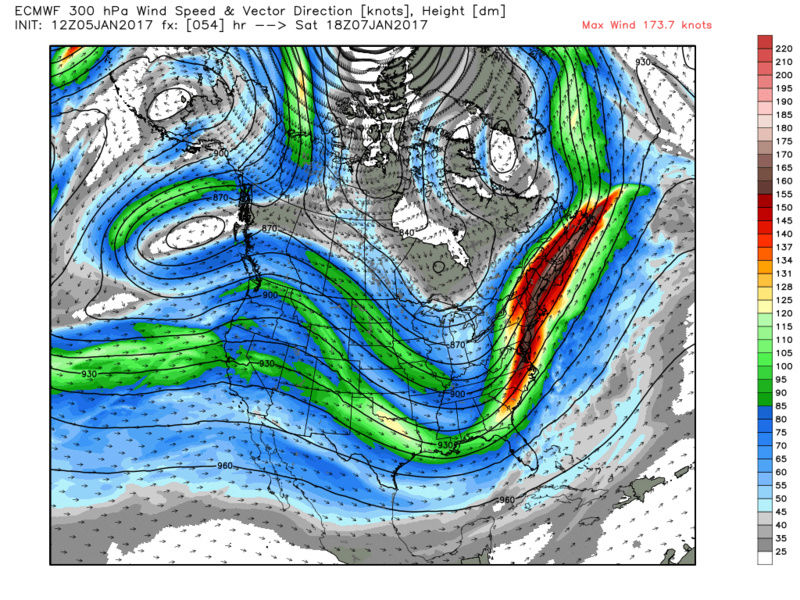
![]() by Armando Salvadore Thu Jan 05, 2017 1:18 pm
by Armando Salvadore Thu Jan 05, 2017 1:18 pm
0z EURO from last night - 300mb jet streak
shield
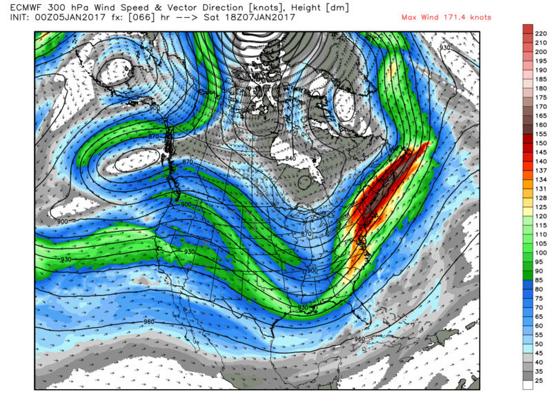
12z EURO today 300mb jet streak. Improved UL jet streak argues for more of convective growth in the precipitation
Armando Salvadore- Advanced Forecaster
- Posts : 171
Reputation : 0
Join date : 2016-12-23
Location : Springfield, NJ
Re: January 7th-8th Wave 2 Snow Event
![]() by nutleyblizzard Thu Jan 05, 2017 1:18 pm
by nutleyblizzard Thu Jan 05, 2017 1:18 pm
My question is did the models ingest the full sampling of the northern vort and make the full adjustment NW, or is it more of a trend west commencing?Armando Salvadore wrote:Much better improvements on the 12z EURO. As frank has been stating, better ridge axis, stronger/consilodated southern max, sharper trough, and better heights along the coast. One more shift and it's nearly warning criteria. No coincidence with better sampling we are seeing subtle shifts.

nutleyblizzard- Senior Enthusiast
- Posts : 1952
Reputation : 41
Join date : 2014-01-30
Age : 58
Location : Nutley, new jersey
Re: January 7th-8th Wave 2 Snow Event
![]() by skinsfan1177 Thu Jan 05, 2017 1:19 pm
by skinsfan1177 Thu Jan 05, 2017 1:19 pm

skinsfan1177- Senior Enthusiast
- Posts : 4485
Reputation : 35
Join date : 2013-01-07
Age : 46
Location : Point Pleasant Boro
Re: January 7th-8th Wave 2 Snow Event
![]() by Frank_Wx Thu Jan 05, 2017 1:19 pm
by Frank_Wx Thu Jan 05, 2017 1:19 pm
nutleyblizzard wrote:My question is did the models ingest the full sampling of the northern vort and make the full adjustment NW, or is it more of a trend west commencing?Armando Salvadore wrote:Much better improvements on the 12z EURO. As frank has been stating, better ridge axis, stronger/consilodated southern max, sharper trough, and better heights along the coast. One more shift and it's nearly warning criteria. No coincidence with better sampling we are seeing subtle shifts.
They are adjusting based off better sampling of the southern s/w, IMO. It looks like a stronger southern s/w resulted in a sharper trough which drew heights to rise along the EC. They will not have good handling of the northern s/w until tonight 00z, but better yet tomorrow 12z.
_________________
_______________________________________________________________________________________________________
CLICK HERE to view NJ Strong Snowstorm Classifications
Frank_Wx- Godzilla Seeker
- Posts : 21305
Reputation : 328
Join date : 2013-01-05
Age : 31
Location : Jersey City, NJ -
Re: January 7th-8th Wave 2 Snow Event
![]() by weatherwatchermom Thu Jan 05, 2017 1:22 pm
by weatherwatchermom Thu Jan 05, 2017 1:22 pm
thank you for explaining....I know you are busy!! keep up the good work...looking forward to the chat tonight...just registering...Frank_Wx wrote:weatherwatchermom wrote:Frank_Wx wrote:24 hour 500mb height anomaly changes. Unbelievable.
is it a good change or bad change
Good. The red signifies better ridge amplification in the west. The blue in the southeast signifies a sharper trough and better heights up the coast.
weatherwatchermom- Senior Enthusiast
- Posts : 3738
Reputation : 77
Join date : 2014-11-25
Age : 60
Location : Hazlet Township, NJ
Re: January 7th-8th Wave 2 Snow Event
![]() by Snow88 Thu Jan 05, 2017 1:29 pm
by Snow88 Thu Jan 05, 2017 1:29 pm

Snow88- Senior Enthusiast
- Posts : 2193
Reputation : 4
Join date : 2013-01-09
Age : 35
Location : Brooklyn, NY
Re: January 7th-8th Wave 2 Snow Event
![]() by CPcantmeasuresnow Thu Jan 05, 2017 1:36 pm
by CPcantmeasuresnow Thu Jan 05, 2017 1:36 pm
With that said if this does come to fruition for my coastal friends it is quite a cou for our experts here. I have never seen precipitation probablilties on any sight above 20% for even the coast so the fact you guys have not written it off to this point is quite extraordinary. More so if it actually happens.

CPcantmeasuresnow- Wx Statistician Guru

- Posts : 7274
Reputation : 230
Join date : 2013-01-07
Age : 103
Location : Eastern Orange County, NY
Re: January 7th-8th Wave 2 Snow Event
![]() by Snow88 Thu Jan 05, 2017 1:40 pm
by Snow88 Thu Jan 05, 2017 1:40 pm
ftp://ftp.cdc.noaa.gov/Public/gbates/reforecast2/teleconn/4indices.png
Snow88- Senior Enthusiast
- Posts : 2193
Reputation : 4
Join date : 2013-01-09
Age : 35
Location : Brooklyn, NY
Re: January 7th-8th Wave 2 Snow Event
![]() by aiannone Thu Jan 05, 2017 1:41 pm
by aiannone Thu Jan 05, 2017 1:41 pm
_________________
-Alex Iannone-

aiannone- Senior Enthusiast - Mod

- Posts : 4813
Reputation : 92
Join date : 2013-01-07
Location : Saint James, LI (Northwest Suffolk Co.)
Re: January 7th-8th Wave 2 Snow Event
![]() by Quietace Thu Jan 05, 2017 1:47 pm
by Quietace Thu Jan 05, 2017 1:47 pm

Quietace- Meteorologist - Mod

- Posts : 3687
Reputation : 33
Join date : 2013-01-07
Age : 27
Location : Point Pleasant, NJ
Re: January 7th-8th Wave 2 Snow Event
![]() by jake732 Thu Jan 05, 2017 1:55 pm
by jake732 Thu Jan 05, 2017 1:55 pm
jake732- Pro Enthusiast
- Posts : 449
Reputation : 0
Join date : 2016-01-03
Location : lakewood, nj -
Re: January 7th-8th Wave 2 Snow Event
![]() by jmanley32 Thu Jan 05, 2017 1:59 pm
by jmanley32 Thu Jan 05, 2017 1:59 pm
in what way is not right?Quietace wrote:I don't know what it is, but I just keep looking at H5 and H250, and then look at the surface and say something is off.

jmanley32- Senior Enthusiast
- Posts : 20516
Reputation : 108
Join date : 2013-12-12
Age : 42
Location : Yonkers, NY
Re: January 7th-8th Wave 2 Snow Event
![]() by nutleyblizzard Thu Jan 05, 2017 2:01 pm
by nutleyblizzard Thu Jan 05, 2017 2:01 pm
Its possible the models haven't "caught up" with the surface reflection with the major changes at the 500mb level. I think thats why Frank is having a chat tonight even though the models currently show a glancing blow at the moment.Quietace wrote:I don't know what it is, but I just keep looking at H5 and H250, and then look at the surface and say something is off.
nutleyblizzard- Senior Enthusiast
- Posts : 1952
Reputation : 41
Join date : 2014-01-30
Age : 58
Location : Nutley, new jersey
Re: January 7th-8th Wave 2 Snow Event
![]() by weatherwatchermom Thu Jan 05, 2017 2:02 pm
by weatherwatchermom Thu Jan 05, 2017 2:02 pm
aiannone wrote:Precip shield much further west with 12z Euro. As Frank says, this run was also "a pubic hair away." lol
that is such a gross way of explaining...lol
weatherwatchermom- Senior Enthusiast
- Posts : 3738
Reputation : 77
Join date : 2014-11-25
Age : 60
Location : Hazlet Township, NJ
Re: January 7th-8th Wave 2 Snow Event
![]() by jmanley32 Thu Jan 05, 2017 2:03 pm
by jmanley32 Thu Jan 05, 2017 2:03 pm
so thinking this could come further west let's hope it keeps dping so and gets us into the real good stuff.nutleyblizzard wrote:Its possible the models haven't "caught up" with the surface reflection with the major changes at the 500mb level. I think thats why Frank is having a chat tonight even though the models currently show a glancing blow at the moment.Quietace wrote:I don't know what it is, but I just keep looking at H5 and H250, and then look at the surface and say something is off.
jmanley32- Senior Enthusiast
- Posts : 20516
Reputation : 108
Join date : 2013-12-12
Age : 42
Location : Yonkers, NY
Re: January 7th-8th Wave 2 Snow Event
![]() by Quietace Thu Jan 05, 2017 2:03 pm
by Quietace Thu Jan 05, 2017 2:03 pm
I know that is the reason. We have had this issue before, just waiting for models to adjust the surface representation.nutleyblizzard wrote:Its possible the models haven't "caught up" with the surface reflection with the major changes at the 500mb level. I think thats why Frank is having a chat tonight even though the models currently show a glancing blow at the moment.Quietace wrote:I don't know what it is, but I just keep looking at H5 and H250, and then look at the surface and say something is off.
Quietace- Meteorologist - Mod
- Posts : 3687
Reputation : 33
Join date : 2013-01-07
Age : 27
Location : Point Pleasant, NJ
Page 10 of 25 • 1 ... 6 ... 9, 10, 11 ... 17 ... 25 ![]()
|
|
|