
 Search
Long Range Thread 13.0
Page 11 of 40 •  1 ... 7 ... 10, 11, 12 ... 25 ... 40
 ![]()
Re: Long Range Thread 13.0
![]() by Frank_Wx Tue Jan 31, 2017 7:59 pm
by Frank_Wx Tue Jan 31, 2017 7:59 pm
This being said, there remains hope following the cutter we see the pattern turn favorable for a period of time. It may be just a 1 week period, but we'll take it. I'm not saying the Strat and MJO forecasts I presented in my videos will not come to fruition. These events are still on track to take place. What impacts or affects they bring to our pattern remains to be seen, but I can only think they'll be positive based off historical data and where they're expected to occur.
Besides tomorrow, we'll be below normal through Sunday. We're likely to be above normal next week but the cold should reload behind the cutter. The question then becomes will the MJO bring about western ridging again, and will the Stratospheric warming develop a favorable -AO/-NAO couplet. I'm hopeful the answer is yes. After February 10th.
Frank_Wx- Godzilla Seeker

- Posts : 21305
Join date : 2013-01-05 -

Re: Long Range Thread 13.0
![]() by Armando Salvadore Tue Jan 31, 2017 10:51 pm
by Armando Salvadore Tue Jan 31, 2017 10:51 pm
Frank_Wx wrote:I'll be the first to admit the pattern between the 5th and 10th is not what I expected to happen. I did not expect an anomalous positive EPO to develop, nor for the Pacific Jet to amplify as much as models are showing. The SOI is also in LA Nina territory for the first time in awhile. What we're left with is a weak, or possibly non existent system, on the 6th. The threat around the 8th is likely to cut based off the aforementioned reasons too.
This being said, there remains hope following the cutter we see the pattern turn favorable for a period of time. It may be just a 1 week period, but we'll take it. I'm not saying the Strat and MJO forecasts I presented in my videos will not come to fruition. These events are still on track to take place. What impacts or affects they bring to our pattern remains to be seen, but I can only think they'll be positive based off historical data and where they're expected to occur.
Besides tomorrow, we'll be below normal through Sunday. We're likely to be above normal next week but the cold should reload behind the cutter. The question then becomes will the MJO bring about western ridging again, and will the Stratospheric warming develop a favorable -AO/-NAO couplet. I'm hopeful the answer is yes. After February 10th.
Yep agreed on all facets, don't beat yourself up. Don't think many saw it coming, i sure didn't see an erupt +EPO form as such. Now with an undercutting pacific jet extension, there goes any chance of a western ridge. I also should've seen the state of the MJO since its composites for N.A. and its transition into the MC was not favorable for any winter events for the EC. However, i did analyze some guidance earlier and noticed models match the phase 7/8 composite between the 11th-15th, so not all is lost. That cutter, is what is likely to help shift the rossby wave train stationed over Greenland, and by doing so, we probably will have our best shot of the season. As for post mid month, gee, i'd rather not take a stab at it just because of the volatility that this months presents and what occurs with the SPV.
Armando Salvadore- Advanced Forecaster

- Posts : 171
Join date : 2016-12-23
Re: Long Range Thread 13.0
![]() by nutleyblizzard Wed Feb 01, 2017 6:38 am
by nutleyblizzard Wed Feb 01, 2017 6:38 am

nutleyblizzard- Senior Enthusiast

- Posts : 1952
Reputation : 41
Join date : 2014-01-30
Age : 58
Location : Nutley, new jersey
Re: Long Range Thread 13.0
![]() by Guest Wed Feb 01, 2017 7:00 am
by Guest Wed Feb 01, 2017 7:00 am
Guest- Guest
Re: Long Range Thread 13.0
![]() by nutleyblizzard Wed Feb 01, 2017 7:04 am
by nutleyblizzard Wed Feb 01, 2017 7:04 am
Yep. That trailing low looks like a new feature. The EURO shows it too.TheAresian wrote:I think that the original 8-9th system still cuts with the coastal being a new low.
nutleyblizzard- Senior Enthusiast
- Posts : 1952
Reputation : 41
Join date : 2014-01-30
Age : 58
Location : Nutley, new jersey
Re: Long Range Thread 13.0
![]() by sroc4 Wed Feb 01, 2017 7:35 am
by sroc4 Wed Feb 01, 2017 7:35 am
_________________
"In weather and in life, there's no winning and losing; there's only winning and learning."
WINTER 2012/2013 TOTALS 43.65"WINTER 2017/2018 TOTALS 62.85" WINTER 2022/2023 TOTALS 4.9"
WINTER 2013/2014 TOTALS 64.85"WINTER 2018/2019 TOTALS 14.25" WINTER 2023/2024 TOTALS 13.1"
WINTER 2014/2015 TOTALS 71.20"WINTER 2019/2020 TOTALS 6.35"
WINTER 2015/2016 TOTALS 35.00"WINTER 2020/2021 TOTALS 37.75"
WINTER 2016/2017 TOTALS 42.25"WINTER 2021/2022 TOTALS 31.65"

sroc4- Admin
- Posts : 8331
Reputation : 301
Join date : 2013-01-07
Location : Wading River, LI
Re: Long Range Thread 13.0
![]() by Frank_Wx Wed Feb 01, 2017 7:55 am
by Frank_Wx Wed Feb 01, 2017 7:55 am

By the 15th, the GEFS ridge bridge the NAO/PNA.

The EPS also take the NAO negative by the 8th or so.
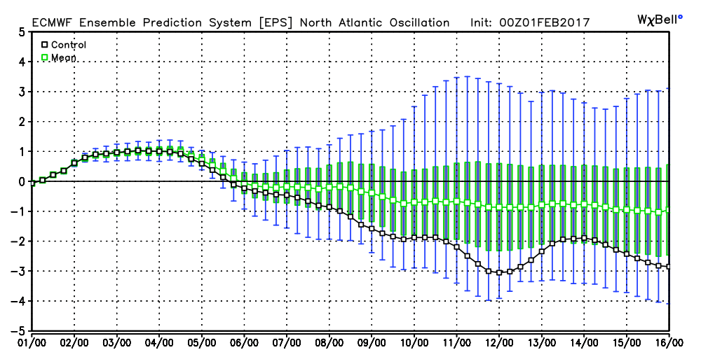
It's quite possible the cutter changes our pattern for the better, but let's see how things look after this weekend.
_________________
_______________________________________________________________________________________________________
CLICK HERE to view NJ Strong Snowstorm Classifications

Frank_Wx- Godzilla Seeker
- Posts : 21305
Reputation : 328
Join date : 2013-01-05
Age : 31
Location : Jersey City, NJ -
Re: Long Range Thread 13.0
![]() by Isotherm Wed Feb 01, 2017 9:17 am
by Isotherm Wed Feb 01, 2017 9:17 am
Isotherm- Advanced Forecaster
- Posts : 231
Reputation : 4
Join date : 2014-09-01
Age : 33
Location : Monmouth County, NJ -
Re: Long Range Thread 13.0
![]() by billg315 Wed Feb 01, 2017 12:02 pm
by billg315 Wed Feb 01, 2017 12:02 pm

billg315- Advanced Forecaster - Mod

- Posts : 4462
Reputation : 185
Join date : 2015-01-24
Age : 50
Location : Flemington, NJ
Re: Long Range Thread 13.0
![]() by sroc4 Wed Feb 01, 2017 12:20 pm
by sroc4 Wed Feb 01, 2017 12:20 pm
_________________
"In weather and in life, there's no winning and losing; there's only winning and learning."
WINTER 2012/2013 TOTALS 43.65"WINTER 2017/2018 TOTALS 62.85" WINTER 2022/2023 TOTALS 4.9"
WINTER 2013/2014 TOTALS 64.85"WINTER 2018/2019 TOTALS 14.25" WINTER 2023/2024 TOTALS 13.1"
WINTER 2014/2015 TOTALS 71.20"WINTER 2019/2020 TOTALS 6.35"
WINTER 2015/2016 TOTALS 35.00"WINTER 2020/2021 TOTALS 37.75"
WINTER 2016/2017 TOTALS 42.25"WINTER 2021/2022 TOTALS 31.65"
sroc4- Admin
- Posts : 8331
Reputation : 301
Join date : 2013-01-07
Location : Wading River, LI
Re: Long Range Thread 13.0
![]() by algae888 Wed Feb 01, 2017 12:34 pm
by algae888 Wed Feb 01, 2017 12:34 pm
Scott I totally agree. whether we get snow on Sunday what this system will almost certainly do is bring a piece of the polar vortex down into Southeast Canada as it intensifies in the maritimes. This could set up an interesting scenario with the wave to follow. At this time I'd be leaning against a big wound up cutter in the mid part of the country. I would expect the wave coming on Shore in the Pacific after the February 6th storm to weaken as it heads East. Models have consistently shown these woundup Cutters this year that never seemed to materializesroc4 wrote:I understand why people are throwing in the towel, but you really should hold off in doing so.

algae888- Advanced Forecaster
- Posts : 5311
Reputation : 46
Join date : 2013-02-05
Age : 61
Location : mt. vernon, new york
Re: Long Range Thread 13.0
![]() by Guest Wed Feb 01, 2017 12:52 pm
by Guest Wed Feb 01, 2017 12:52 pm
I'm going to wait this thread out on the sidelines thank you very much.
Guest- Guest
Re: Long Range Thread 13.0
![]() by Frank_Wx Wed Feb 01, 2017 1:05 pm
by Frank_Wx Wed Feb 01, 2017 1:05 pm
syosnow94 wrote:Crap..... It took just one day to get Frank to show some optimism again, even using the phrase MADONNE!
I'm going to wait this thread out on the sidelines thank you very much.
My pessimism stemmed from the failed storm attempt on Sunday. But the 8th on today's model runs isn't all that warm. SCI stayed at 5% this morning. Will look at things closer again later on.
_________________
_______________________________________________________________________________________________________
CLICK HERE to view NJ Strong Snowstorm Classifications
Frank_Wx- Godzilla Seeker
- Posts : 21305
Reputation : 328
Join date : 2013-01-05
Age : 31
Location : Jersey City, NJ -
Re: Long Range Thread 13.0
![]() by nutleyblizzard Wed Feb 01, 2017 1:16 pm
by nutleyblizzard Wed Feb 01, 2017 1:16 pm
Frank why do you think the storm on the 8th is trending colder? The H5 levels are changing which is causing the storm to organize further south and east. One of the changes I've noticed is a much colder regime in Canada infiltrating the U.S. Could it be the models are having issues with the MJO?Frank_Wx wrote:syosnow94 wrote:Crap..... It took just one day to get Frank to show some optimism again, even using the phrase MADONNE!
I'm going to wait this thread out on the sidelines thank you very much.
My pessimism stemmed from the failed storm attempt on Sunday. But the 8th on today's model runs isn't all that warm. SCI stayed at 5% this morning. Will look at things closer again later on.
nutleyblizzard- Senior Enthusiast
- Posts : 1952
Reputation : 41
Join date : 2014-01-30
Age : 58
Location : Nutley, new jersey
Re: Long Range Thread 13.0
![]() by sroc4 Wed Feb 01, 2017 1:26 pm
by sroc4 Wed Feb 01, 2017 1:26 pm
nutleyblizzard wrote:Frank why do you think the storm on the 8th is trending colder? The H5 levels are changing which is causing the storm to organize further south and east. One of the changes I've noticed is a much colder regime in Canada infiltrating the U.S. Could it be the models are having issues with the MJO?Frank_Wx wrote:syosnow94 wrote:Crap..... It took just one day to get Frank to show some optimism again, even using the phrase MADONNE!
I'm going to wait this thread out on the sidelines thank you very much.
My pessimism stemmed from the failed storm attempt on Sunday. But the 8th on today's model runs isn't all that warm. SCI stayed at 5% this morning. Will look at things closer again later on.
Nuts models have trouble all year with the MJO and its influences on the overall pattern.
_________________
"In weather and in life, there's no winning and losing; there's only winning and learning."
WINTER 2012/2013 TOTALS 43.65"WINTER 2017/2018 TOTALS 62.85" WINTER 2022/2023 TOTALS 4.9"
WINTER 2013/2014 TOTALS 64.85"WINTER 2018/2019 TOTALS 14.25" WINTER 2023/2024 TOTALS 13.1"
WINTER 2014/2015 TOTALS 71.20"WINTER 2019/2020 TOTALS 6.35"
WINTER 2015/2016 TOTALS 35.00"WINTER 2020/2021 TOTALS 37.75"
WINTER 2016/2017 TOTALS 42.25"WINTER 2021/2022 TOTALS 31.65"
sroc4- Admin
- Posts : 8331
Reputation : 301
Join date : 2013-01-07
Location : Wading River, LI
Re: Long Range Thread 13.0
![]() by Isotherm Wed Feb 01, 2017 2:54 pm
by Isotherm Wed Feb 01, 2017 2:54 pm
Isotherm- Advanced Forecaster
- Posts : 231
Reputation : 4
Join date : 2014-09-01
Age : 33
Location : Monmouth County, NJ -
Re: Long Range Thread 13.0
![]() by Frank_Wx Wed Feb 01, 2017 3:12 pm
by Frank_Wx Wed Feb 01, 2017 3:12 pm
Isotherm wrote: Ecmwf and GFS are concurring on a coherent p8 MJO propagation post D10. Will be interesting to monitor constructive interference with ongoing precursor. I am becoming more confident that a negative NAM period will occur (NAO too) regardless of whether we destroy the upper stratospheric vorticies, though obviously ideal. W 1/W2 follow up are typically effective.

_________________
_______________________________________________________________________________________________________
CLICK HERE to view NJ Strong Snowstorm Classifications
Frank_Wx- Godzilla Seeker
- Posts : 21305
Reputation : 328
Join date : 2013-01-05
Age : 31
Location : Jersey City, NJ -
Re: Long Range Thread 13.0
![]() by Armando Salvadore Wed Feb 01, 2017 4:00 pm
by Armando Salvadore Wed Feb 01, 2017 4:00 pm
[img]
 [/img]
Tom, you've been all over the latter half of Feb, great stuff! Think we're beginning to see that NAM alteration on the ensembles in the LR. We're not leaving this month without something producing!

Armando Salvadore- Advanced Forecaster
- Posts : 171
Reputation : 0
Join date : 2016-12-23
Location : Springfield, NJ
Re: Long Range Thread 13.0
![]() by rb924119 Wed Feb 01, 2017 4:24 pm
by rb924119 Wed Feb 01, 2017 4:24 pm
rb924119- Meteorologist

- Posts : 6889
Reputation : 194
Join date : 2013-02-06
Age : 32
Location : Greentown, Pa
Re: Long Range Thread 13.0
![]() by jmanley32 Wed Feb 01, 2017 4:32 pm
by jmanley32 Wed Feb 01, 2017 4:32 pm
rb924119 wrote:A lot, and I mean A LOT of heavy hitting individual Euro Ensemble members by day 15 lol like, the things dreams are made of ahaha many of the ones I'm referencing are roidzillas verbatim, without ratios or anything else. If "ifs" and "buts" were candies and nuts, we all would have had a merry(ier) Christmas lmfao
wow ur not kidding but 15 days out ive seen those clown maps plenty of times. we can only hope.

jmanley32- Senior Enthusiast
- Posts : 20513
Reputation : 108
Join date : 2013-12-12
Age : 42
Location : Yonkers, NY
Re: Long Range Thread 13.0
![]() by sroc4 Wed Feb 01, 2017 4:42 pm
by sroc4 Wed Feb 01, 2017 4:42 pm
rb924119 wrote:A lot, and I mean A LOT of heavy hitting individual Euro Ensemble members by day 15 lol like, the things dreams are made of ahaha many of the ones I'm referencing are roidzillas verbatim, without ratios or anything else. If "ifs" and "buts" were candies and nuts, we all would have had a merry(ier) Christmas lmfao
Number 47 please
_________________
"In weather and in life, there's no winning and losing; there's only winning and learning."
WINTER 2012/2013 TOTALS 43.65"WINTER 2017/2018 TOTALS 62.85" WINTER 2022/2023 TOTALS 4.9"
WINTER 2013/2014 TOTALS 64.85"WINTER 2018/2019 TOTALS 14.25" WINTER 2023/2024 TOTALS 13.1"
WINTER 2014/2015 TOTALS 71.20"WINTER 2019/2020 TOTALS 6.35"
WINTER 2015/2016 TOTALS 35.00"WINTER 2020/2021 TOTALS 37.75"
WINTER 2016/2017 TOTALS 42.25"WINTER 2021/2022 TOTALS 31.65"
sroc4- Admin
- Posts : 8331
Reputation : 301
Join date : 2013-01-07
Location : Wading River, LI

jake732- Pro Enthusiast

- Posts : 449
Reputation : 0
Join date : 2016-01-03
Location : lakewood, nj -
Re: Long Range Thread 13.0
![]() by Frank_Wx Wed Feb 01, 2017 7:11 pm
by Frank_Wx Wed Feb 01, 2017 7:11 pm
30hPa Euro PV split

Euro control and euro means show a fantasy snowstorm around the 12th.

_________________
_______________________________________________________________________________________________________
CLICK HERE to view NJ Strong Snowstorm Classifications
Frank_Wx- Godzilla Seeker
- Posts : 21305
Reputation : 328
Join date : 2013-01-05
Age : 31
Location : Jersey City, NJ -
Re: Long Range Thread 13.0
![]() by Frank_Wx Wed Feb 01, 2017 7:12 pm
by Frank_Wx Wed Feb 01, 2017 7:12 pm
.gif.107f389a0cce6d08e75eb78a8b3bfaa2.gif)
_________________
_______________________________________________________________________________________________________
CLICK HERE to view NJ Strong Snowstorm Classifications
Frank_Wx- Godzilla Seeker
- Posts : 21305
Reputation : 328
Join date : 2013-01-05
Age : 31
Location : Jersey City, NJ -
Re: Long Range Thread 13.0
![]() by Frank_Wx Wed Feb 01, 2017 7:14 pm
by Frank_Wx Wed Feb 01, 2017 7:14 pm

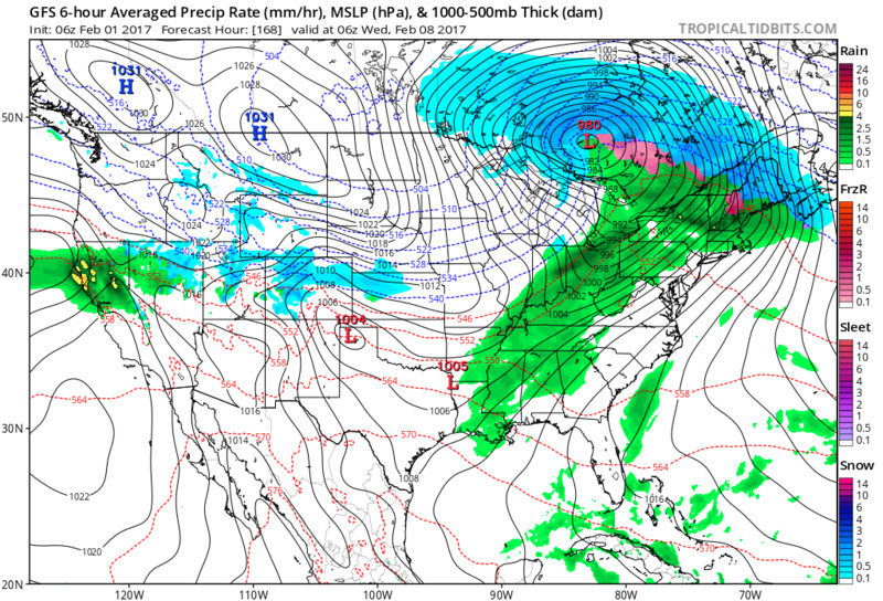
The 8th is not yet a done deal.
_________________
_______________________________________________________________________________________________________
CLICK HERE to view NJ Strong Snowstorm Classifications
Frank_Wx- Godzilla Seeker
- Posts : 21305
Reputation : 328
Join date : 2013-01-05
Age : 31
Location : Jersey City, NJ -
Re: Long Range Thread 13.0
![]() by sroc4 Wed Feb 01, 2017 8:45 pm
by sroc4 Wed Feb 01, 2017 8:45 pm
_________________
"In weather and in life, there's no winning and losing; there's only winning and learning."
WINTER 2012/2013 TOTALS 43.65"WINTER 2017/2018 TOTALS 62.85" WINTER 2022/2023 TOTALS 4.9"
WINTER 2013/2014 TOTALS 64.85"WINTER 2018/2019 TOTALS 14.25" WINTER 2023/2024 TOTALS 13.1"
WINTER 2014/2015 TOTALS 71.20"WINTER 2019/2020 TOTALS 6.35"
WINTER 2015/2016 TOTALS 35.00"WINTER 2020/2021 TOTALS 37.75"
WINTER 2016/2017 TOTALS 42.25"WINTER 2021/2022 TOTALS 31.65"
sroc4- Admin
- Posts : 8331
Reputation : 301
Join date : 2013-01-07
Location : Wading River, LI
Re: Long Range Thread 13.0
![]() by Isotherm Wed Feb 01, 2017 9:20 pm
by Isotherm Wed Feb 01, 2017 9:20 pm
Armando Salvadore wrote:12Z GEFS today = carbon copy of what PHASE 8 COMPOSITE LOOKS LIKE...
Tom, you've been all over the latter half of Feb, great stuff! Think we're beginning to see that NAM alteration on the ensembles in the LR. We're not leaving this month without something producing!
Thanks man. Hopefully it continues evolving as expected.
Even if we were waiting patiently for a typical downwelling event, the integral part of the whole process is resultant tropospheric conditions. The fact that we severely perturb the troposphere w/ upwelling wave activity following an upper vortex weakening is a fairly good place to be.
Recall 2010-11 is an example I was just thinking of w/ a very perturbed trop/lower strat but no SSW / near normal zonal winds up at 10hpa. Sometimes one doesn't need a full collapse in the upper realms.
Should be enlightening at the very least.
Isotherm- Advanced Forecaster
- Posts : 231
Reputation : 4
Join date : 2014-09-01
Age : 33
Location : Monmouth County, NJ -
Page 11 of 40 • 1 ... 7 ... 10, 11, 12 ... 25 ... 40 ![]()
|
|
|