
 Search
Long Range Thread 13.0
Page 10 of 40 •  1 ... 6 ... 9, 10, 11 ... 25 ... 40
 ![]()
Re: Long Range Thread 13.0
![]() by rb924119 Mon Jan 30, 2017 6:52 pm
by rb924119 Mon Jan 30, 2017 6:52 pm
https://drive.google.com/open?id=0Byod2Sk27yNYdlpabi13SldOSkU
Enjoy!!! Again, if you have any questions or comments, FEEL FREE to ask!!
rb924119- Meteorologist

- Posts : 6890
Join date : 2013-02-06
Re: Long Range Thread 13.0
![]() by Guest Mon Jan 30, 2017 7:10 pm
by Guest Mon Jan 30, 2017 7:10 pm
https://youtu.be/WLyiHHEHylw
Guest- Guest
Re: Long Range Thread 13.0
![]() by skinsfan1177 Mon Jan 30, 2017 7:19 pm
by skinsfan1177 Mon Jan 30, 2017 7:19 pm
rb924119 wrote:As promised:
https://drive.google.com/open?id=0Byod2Sk27yNYdlpabi13SldOSkU
Enjoy!!! Again, if you have any questions or comments, FEEL FREE to ask!!
Great video rb easy to understand and let's us now where we are going

skinsfan1177- Senior Enthusiast

- Posts : 4485
Reputation : 35
Join date : 2013-01-07
Age : 46
Location : Point Pleasant Boro
Re: Long Range Thread 13.0
![]() by Guest Mon Jan 30, 2017 7:44 pm
by Guest Mon Jan 30, 2017 7:44 pm
Guest- Guest
Re: Long Range Thread 13.0
![]() by Frank_Wx Mon Jan 30, 2017 8:39 pm
by Frank_Wx Mon Jan 30, 2017 8:39 pm
_________________
_______________________________________________________________________________________________________
CLICK HERE to view NJ Strong Snowstorm Classifications

Frank_Wx- Godzilla Seeker

- Posts : 21305
Reputation : 328
Join date : 2013-01-05
Age : 31
Location : Jersey City, NJ -

Re: Long Range Thread 13.0
![]() by Guest Mon Jan 30, 2017 8:40 pm
by Guest Mon Jan 30, 2017 8:40 pm
Guest- Guest
Re: Long Range Thread 13.0
![]() by rb924119 Mon Jan 30, 2017 8:40 pm
by rb924119 Mon Jan 30, 2017 8:40 pm
rb924119- Meteorologist
- Posts : 6890
Reputation : 194
Join date : 2013-02-06
Age : 32
Location : Greentown, Pa
Re: Long Range Thread 13.0
![]() by rb924119 Mon Jan 30, 2017 8:42 pm
by rb924119 Mon Jan 30, 2017 8:42 pm
Frank_Wx wrote:If the polar energy is strong enough, it can lift heights along the EC on its own which gives path for the southern energy to come up the coast. It depends on the set-up.
This is a great point too, and one I didn't even think of to be honest aha
rb924119- Meteorologist
- Posts : 6890
Reputation : 194
Join date : 2013-02-06
Age : 32
Location : Greentown, Pa
Re: Long Range Thread 13.0
![]() by Frank_Wx Mon Jan 30, 2017 8:45 pm
by Frank_Wx Mon Jan 30, 2017 8:45 pm
12z:

18z:

_________________
_______________________________________________________________________________________________________
CLICK HERE to view NJ Strong Snowstorm Classifications
Frank_Wx- Godzilla Seeker
- Posts : 21305
Reputation : 328
Join date : 2013-01-05
Age : 31
Location : Jersey City, NJ -
Re: Long Range Thread 13.0
![]() by Guest Mon Jan 30, 2017 8:46 pm
by Guest Mon Jan 30, 2017 8:46 pm
rb924119 wrote:Thanks, Skins! And Aresian, in my opinion, kind of. Even if there isn't a large enough southeastern ridge to allow the interaction of energy, it should still allow for frozen precipitation because it will still be a relatively fresh cold airmass ahead of it, BUT the overall amount of precipitation that falls won't be as large. Granted, there could be a changeover, but I'm not worried about those details yet, and for you, it seems unlikely at this point anyway aha
For me, the B in Miller B stands for "Bane of My Existence".
Guest- Guest
Re: Long Range Thread 13.0
![]() by Fededle22 Mon Jan 30, 2017 8:52 pm
by Fededle22 Mon Jan 30, 2017 8:52 pm

Fededle22- Posts : 169
Reputation : 2
Join date : 2013-03-08
Location : West Orange, NJ
Re: Long Range Thread 13.0
![]() by Frank_Wx Mon Jan 30, 2017 8:54 pm
by Frank_Wx Mon Jan 30, 2017 8:54 pm

_________________
_______________________________________________________________________________________________________
CLICK HERE to view NJ Strong Snowstorm Classifications
Frank_Wx- Godzilla Seeker
- Posts : 21305
Reputation : 328
Join date : 2013-01-05
Age : 31
Location : Jersey City, NJ -
Re: Long Range Thread 13.0
![]() by Frank_Wx Mon Jan 30, 2017 8:55 pm
by Frank_Wx Mon Jan 30, 2017 8:55 pm
Fededle22 wrote:This is going to be a long week of tracking! I am definitely hoping for snow but would prefer it now impacting my super bowl party and the safety of my guests getting home. Is it safe to say that all we want at this point is a strong storm indicator and not location or precip type?
Correct. Once we determine whether or not there will even be a storm, then we'll focus on precipitation type and timing.
_________________
_______________________________________________________________________________________________________
CLICK HERE to view NJ Strong Snowstorm Classifications
Frank_Wx- Godzilla Seeker
- Posts : 21305
Reputation : 328
Join date : 2013-01-05
Age : 31
Location : Jersey City, NJ -
Re: Long Range Thread 13.0
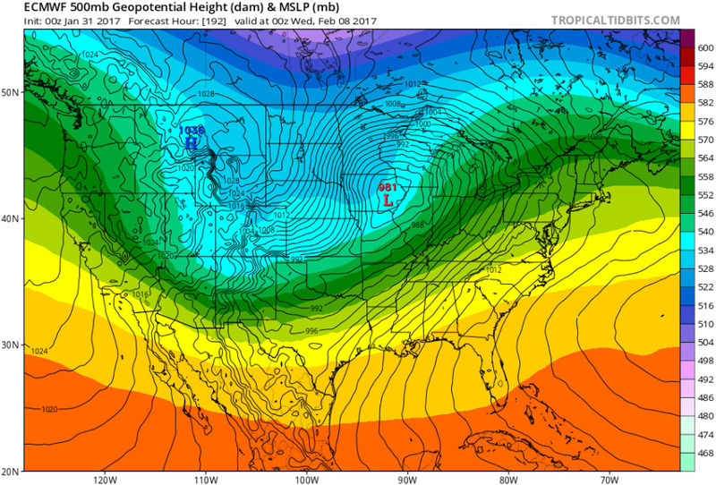
![]() by Math23x7 Tue Jan 31, 2017 2:19 am
by Math23x7 Tue Jan 31, 2017 2:19 am
1/31 0Z ECMWF OP hr 192:
Math23x7- Wx Statistician Guru

- Posts : 2379
Reputation : 68
Join date : 2013-01-08
Re: Long Range Thread 13.0
![]() by skinsfan1177 Tue Jan 31, 2017 5:48 am
by skinsfan1177 Tue Jan 31, 2017 5:48 am
skinsfan1177- Senior Enthusiast
- Posts : 4485
Reputation : 35
Join date : 2013-01-07
Age : 46
Location : Point Pleasant Boro
Re: Long Range Thread 13.0
![]() by nutleyblizzard Tue Jan 31, 2017 5:53 am
by nutleyblizzard Tue Jan 31, 2017 5:53 am
Yep. I was just going to post this myself. I'm hoping the models are having trouble with the impending pattern shift. The models were telling us yesterday of a total pv split. It doesn't make sense. I would love to hear Frank or RB's take on this.skinsfan1177 wrote:Horrible model runs overnight unless you like 55 and rain .

nutleyblizzard- Senior Enthusiast
- Posts : 1952
Reputation : 41
Join date : 2014-01-30
Age : 58
Location : Nutley, new jersey
Re: Long Range Thread 13.0
![]() by skinsfan1177 Tue Jan 31, 2017 6:17 am
by skinsfan1177 Tue Jan 31, 2017 6:17 am
nutleyblizzard wrote:Yep. I was just going to post this myself. I'm hoping the models are having trouble with the impending pattern shift. The models were telling us yesterday of a total pv split. It doesn't make sense. I would love to hear Frank or RB's take on this.skinsfan1177 wrote:Horrible model runs overnight unless you like 55 and rain .
Its possible they are struggling with the mjo or the Euro is schooling them. Hopefully someone with better knowledge can explain.
skinsfan1177- Senior Enthusiast
- Posts : 4485
Reputation : 35
Join date : 2013-01-07
Age : 46
Location : Point Pleasant Boro
Re: Long Range Thread 13.0
![]() by Frank_Wx Tue Jan 31, 2017 7:48 am
by Frank_Wx Tue Jan 31, 2017 7:48 am

_________________
_______________________________________________________________________________________________________
CLICK HERE to view NJ Strong Snowstorm Classifications
Frank_Wx- Godzilla Seeker
- Posts : 21305
Reputation : 328
Join date : 2013-01-05
Age : 31
Location : Jersey City, NJ -
Re: Long Range Thread 13.0
![]() by sroc4 Tue Jan 31, 2017 8:32 am
by sroc4 Tue Jan 31, 2017 8:32 am
skinsfan1177 wrote:nutleyblizzard wrote:Yep. I was just going to post this myself. I'm hoping the models are having trouble with the impending pattern shift. The models were telling us yesterday of a total pv split. It doesn't make sense. I would love to hear Frank or RB's take on this.skinsfan1177 wrote:Horrible model runs overnight unless you like 55 and rain .
Its possible they are struggling with the mjo or the Euro is schooling them. Hopefully someone with better knowledge can explain.
Yes and yes on both points Skins. Write up coming
_________________
"In weather and in life, there's no winning and losing; there's only winning and learning."
WINTER 2012/2013 TOTALS 43.65"WINTER 2017/2018 TOTALS 62.85" WINTER 2022/2023 TOTALS 4.9"
WINTER 2013/2014 TOTALS 64.85"WINTER 2018/2019 TOTALS 14.25" WINTER 2023/2024 TOTALS 13.1"
WINTER 2014/2015 TOTALS 71.20"WINTER 2019/2020 TOTALS 6.35"
WINTER 2015/2016 TOTALS 35.00"WINTER 2020/2021 TOTALS 37.75"
WINTER 2016/2017 TOTALS 42.25"WINTER 2021/2022 TOTALS 31.65"

sroc4- Admin
- Posts : 8331
Reputation : 301
Join date : 2013-01-07
Location : Wading River, LI
Re: Long Range Thread 13.0
![]() by amugs Tue Jan 31, 2017 8:38 am
by amugs Tue Jan 31, 2017 8:38 am
We actually have a nice -NAO and we cant the pac to cooperate - one of these days Alice!!
-WPO actually gets split there which hurts as well Frank.
===ZONAL
-EPO regresses west over to Russia basically bridging with the Scandinavian block over the top be to far North and the + EPO blocks the cross polar flow on here.
We'll see
_________________
Mugs
AKA:King: Snow Weenie
Self Proclaimed
WINTER 2014-15 : 55.12" +.02 for 6 coatings (avg. 35")
WINTER 2015-16 Total - 29.8" (Avg 35")
WINTER 2016-17 : 39.5" so far

amugs- Advanced Forecaster - Mod

- Posts : 15093
Reputation : 213
Join date : 2013-01-07
Age : 54
Location : Hillsdale,NJ
Re: Long Range Thread 13.0
![]() by Guest Tue Jan 31, 2017 9:15 am
by Guest Tue Jan 31, 2017 9:15 am
Over the past few years I've stated "unscientifically" and probably not too eloquently that we pretty much know how our winter is going to be by late December without even looking at data. If storms are cutting and the cold air is transient by then that is the way the rest of the winter will go. Almost like a vacuum? The atmosphere and therefore storm track keeps repeating itself following the previous storms etc; etc; Last year was a perfect example and so far so is this one.
Guest- Guest
Re: Long Range Thread 13.0
![]() by sroc4 Tue Jan 31, 2017 10:36 am
by sroc4 Tue Jan 31, 2017 10:36 am
_________________
"In weather and in life, there's no winning and losing; there's only winning and learning."
WINTER 2012/2013 TOTALS 43.65"WINTER 2017/2018 TOTALS 62.85" WINTER 2022/2023 TOTALS 4.9"
WINTER 2013/2014 TOTALS 64.85"WINTER 2018/2019 TOTALS 14.25" WINTER 2023/2024 TOTALS 13.1"
WINTER 2014/2015 TOTALS 71.20"WINTER 2019/2020 TOTALS 6.35"
WINTER 2015/2016 TOTALS 35.00"WINTER 2020/2021 TOTALS 37.75"
WINTER 2016/2017 TOTALS 42.25"WINTER 2021/2022 TOTALS 31.65"
sroc4- Admin
- Posts : 8331
Reputation : 301
Join date : 2013-01-07
Location : Wading River, LI
Re: Long Range Thread 13.0
![]() by Isotherm Tue Jan 31, 2017 1:21 pm
by Isotherm Tue Jan 31, 2017 1:21 pm
I am still monitoring the 15th+ period for concurrent w2 / MJO p8 forcing on the vortex. I was saying this elsewhere, but trend worse in storms for the next 10 days isn't surprising. The initial displacement is ineffective insofar as impacts. The question was always what transpires subsequently. The trop based w2 development is legit, I am just conflicted about the extent to which it propagates upward through rhe strat. The vortex will be weaker which certainly helps. And the MJO cooperation will aid WAF. Of course the maintenance of base pattern is still a possibility on the table, but again, the period to monitor to me is really mid month onward for changes.
In sum, nothing has changed much as far as the data. Relying on the strat alone to save winter would typically be playing w fire, but the methos of attack (trop based) coupled with tropical forcing and weakened vortex makes this one more intriguing.
Isotherm- Advanced Forecaster

- Posts : 231
Reputation : 4
Join date : 2014-09-01
Age : 33
Location : Monmouth County, NJ -
Re: Long Range Thread 13.0
![]() by Armando Salvadore Tue Jan 31, 2017 2:19 pm
by Armando Salvadore Tue Jan 31, 2017 2:19 pm

Armando Salvadore- Advanced Forecaster
- Posts : 171
Reputation : 0
Join date : 2016-12-23
Location : Springfield, NJ
Re: Long Range Thread 13.0
![]() by Frank_Wx Tue Jan 31, 2017 7:36 pm
by Frank_Wx Tue Jan 31, 2017 7:36 pm
There's no way to sugar coat this. Although the pattern did change on the 27th of January as expected, and it'll be normal to below the rest of this week (except tomorrow), it's not the pattern change I suspected. My videos clearly pointed to a colder than normal pattern without any warm days mixed in. Now...it's possible after the cutter on the 8th the cold reloads and high latitude blocking becomes more favorable. This gives us another window to see a snowstorm between the 10th and 15th. But there's many factors I have to look over again before committing to that. Especially the Stratosphere and MJO wave.
A disappointing turn of events to say the least.
_________________
_______________________________________________________________________________________________________
CLICK HERE to view NJ Strong Snowstorm Classifications
Frank_Wx- Godzilla Seeker
- Posts : 21305
Reputation : 328
Join date : 2013-01-05
Age : 31
Location : Jersey City, NJ -
Re: Long Range Thread 13.0
![]() by Frank_Wx Tue Jan 31, 2017 7:59 pm
by Frank_Wx Tue Jan 31, 2017 7:59 pm
This being said, there remains hope following the cutter we see the pattern turn favorable for a period of time. It may be just a 1 week period, but we'll take it. I'm not saying the Strat and MJO forecasts I presented in my videos will not come to fruition. These events are still on track to take place. What impacts or affects they bring to our pattern remains to be seen, but I can only think they'll be positive based off historical data and where they're expected to occur.
Besides tomorrow, we'll be below normal through Sunday. We're likely to be above normal next week but the cold should reload behind the cutter. The question then becomes will the MJO bring about western ridging again, and will the Stratospheric warming develop a favorable -AO/-NAO couplet. I'm hopeful the answer is yes. After February 10th.
_________________
_______________________________________________________________________________________________________
CLICK HERE to view NJ Strong Snowstorm Classifications
Frank_Wx- Godzilla Seeker
- Posts : 21305
Reputation : 328
Join date : 2013-01-05
Age : 31
Location : Jersey City, NJ -
Re: Long Range Thread 13.0
![]() by Armando Salvadore Tue Jan 31, 2017 10:51 pm
by Armando Salvadore Tue Jan 31, 2017 10:51 pm
Frank_Wx wrote:I'll be the first to admit the pattern between the 5th and 10th is not what I expected to happen. I did not expect an anomalous positive EPO to develop, nor for the Pacific Jet to amplify as much as models are showing. The SOI is also in LA Nina territory for the first time in awhile. What we're left with is a weak, or possibly non existent system, on the 6th. The threat around the 8th is likely to cut based off the aforementioned reasons too.
This being said, there remains hope following the cutter we see the pattern turn favorable for a period of time. It may be just a 1 week period, but we'll take it. I'm not saying the Strat and MJO forecasts I presented in my videos will not come to fruition. These events are still on track to take place. What impacts or affects they bring to our pattern remains to be seen, but I can only think they'll be positive based off historical data and where they're expected to occur.
Besides tomorrow, we'll be below normal through Sunday. We're likely to be above normal next week but the cold should reload behind the cutter. The question then becomes will the MJO bring about western ridging again, and will the Stratospheric warming develop a favorable -AO/-NAO couplet. I'm hopeful the answer is yes. After February 10th.
Yep agreed on all facets, don't beat yourself up. Don't think many saw it coming, i sure didn't see an erupt +EPO form as such. Now with an undercutting pacific jet extension, there goes any chance of a western ridge. I also should've seen the state of the MJO since its composites for N.A. and its transition into the MC was not favorable for any winter events for the EC. However, i did analyze some guidance earlier and noticed models match the phase 7/8 composite between the 11th-15th, so not all is lost. That cutter, is what is likely to help shift the rossby wave train stationed over Greenland, and by doing so, we probably will have our best shot of the season. As for post mid month, gee, i'd rather not take a stab at it just because of the volatility that this months presents and what occurs with the SPV.
Armando Salvadore- Advanced Forecaster
- Posts : 171
Reputation : 0
Join date : 2016-12-23
Location : Springfield, NJ
Page 10 of 40 • 1 ... 6 ... 9, 10, 11 ... 25 ... 40 ![]()
|
|
|