
 Search
Possible Snowstorm Thursday, February 9th
Page 20 of 26 •  1 ... 11 ... 19, 20, 21 ... 26
 ![]()
Re: Possible Snowstorm Thursday, February 9th
![]() by amugs Tue Feb 07, 2017 2:32 pm
by amugs Tue Feb 07, 2017 2:32 pm

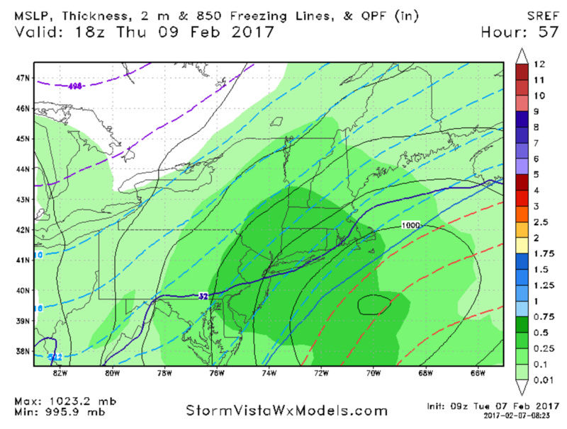
WPC aint fooling around here - 8" or more
Last edited by amugs on Tue Feb 07, 2017 2:33 pm; edited 1 time in total
amugs- Advanced Forecaster - Mod

- Posts : 15093
Join date : 2013-01-07
Re: Possible Snowstorm Thursday, February 9th
![]() by amugs Tue Feb 07, 2017 2:33 pm
by amugs Tue Feb 07, 2017 2:33 pm

amugs- Advanced Forecaster - Mod
- Posts : 15093
Join date : 2013-01-07
Re: Possible Snowstorm Thursday, February 9th
![]() by CPcantmeasuresnow Tue Feb 07, 2017 2:35 pm
by CPcantmeasuresnow Tue Feb 07, 2017 2:35 pm
amugs wrote:6" or more PUT UP THE WSW UPTON 6PM DO SO
Knowing their history I don't think they will until the 4 Am update tonight.

CPcantmeasuresnow- Wx Statistician Guru

- Posts : 7274
Reputation : 230
Join date : 2013-01-07
Age : 103
Location : Eastern Orange County, NY
Re: Possible Snowstorm Thursday, February 9th
![]() by amugs Tue Feb 07, 2017 2:36 pm
by amugs Tue Feb 07, 2017 2:36 pm


_________________
Mugs
AKA:King: Snow Weenie
Self Proclaimed
WINTER 2014-15 : 55.12" +.02 for 6 coatings (avg. 35")
WINTER 2015-16 Total - 29.8" (Avg 35")
WINTER 2016-17 : 39.5" so far

amugs- Advanced Forecaster - Mod
- Posts : 15093
Reputation : 213
Join date : 2013-01-07
Age : 54
Location : Hillsdale,NJ
Re: Possible Snowstorm Thursday, February 9th
![]() by Frank_Wx Tue Feb 07, 2017 2:39 pm
by Frank_Wx Tue Feb 07, 2017 2:39 pm
Frankzilla..........
_________________
_______________________________________________________________________________________________________
CLICK HERE to view NJ Strong Snowstorm Classifications

Frank_Wx- Godzilla Seeker

- Posts : 21305
Reputation : 328
Join date : 2013-01-05
Age : 31
Location : Jersey City, NJ -

Re: Possible Snowstorm Thursday, February 9th
![]() by dsix85 Tue Feb 07, 2017 2:40 pm
by dsix85 Tue Feb 07, 2017 2:40 pm
dsix85- Pro Enthusiast

- Posts : 349
Reputation : 8
Join date : 2014-01-01
Location : New York
Re: Possible Snowstorm Thursday, February 9th
![]() by CPcantmeasuresnow Tue Feb 07, 2017 2:41 pm
by CPcantmeasuresnow Tue Feb 07, 2017 2:41 pm
dsix85 wrote:Frank.. can this storm trend stronger up until the very last minute like we did for the Jan 2016 Blizzard?
Wow, now we're really getting greedy. LOL
CPcantmeasuresnow- Wx Statistician Guru
- Posts : 7274
Reputation : 230
Join date : 2013-01-07
Age : 103
Location : Eastern Orange County, NY
Re: Possible Snowstorm Thursday, February 9th
![]() by dsix85 Tue Feb 07, 2017 2:41 pm
by dsix85 Tue Feb 07, 2017 2:41 pm
dsix85- Pro Enthusiast
- Posts : 349
Reputation : 8
Join date : 2014-01-01
Location : New York
Re: Possible Snowstorm Thursday, February 9th
![]() by gigs68 Tue Feb 07, 2017 2:42 pm
by gigs68 Tue Feb 07, 2017 2:42 pm

gigs68- Posts : 142
Reputation : 3
Join date : 2013-01-16
Location : Commack, NY (NW Suffolk)
Re: Possible Snowstorm Thursday, February 9th
![]() by rb924119 Tue Feb 07, 2017 2:43 pm
by rb924119 Tue Feb 07, 2017 2:43 pm
Frank_Wx wrote:I can't confirm but a member of the SREFS shows 36 inches of snow for KPOU.
Frankzilla..........
I'm not even going to comment on this because that's just asi-9, 10, 11, and 12 lmao
rb924119- Meteorologist

- Posts : 6889
Reputation : 194
Join date : 2013-02-06
Age : 32
Location : Greentown, Pa
Re: Possible Snowstorm Thursday, February 9th
![]() by dsix85 Tue Feb 07, 2017 2:44 pm
by dsix85 Tue Feb 07, 2017 2:44 pm
dsix85- Pro Enthusiast
- Posts : 349
Reputation : 8
Join date : 2014-01-01
Location : New York
Re: Possible Snowstorm Thursday, February 9th
![]() by rb924119 Tue Feb 07, 2017 2:44 pm
by rb924119 Tue Feb 07, 2017 2:44 pm
gigs68 wrote:What's the criteria for Mothrazilla, Godzilla, Frankenzilla etc?
Mothrazilla: 6-11"
Godzilla: 12-23"
Roidzilla: 24-35"
Frankzilla: 36"+
SECS (Significant East Coast Storm): 6-11 inches
MECS (Major East Coast Storm): 12-23 inches
HECS (Historic East Coast Storm): 24-35 inches
BECS (Biblical East Coast Storm): 36+ inches
Last edited by rb924119 on Tue Feb 07, 2017 2:46 pm; edited 1 time in total
rb924119- Meteorologist
- Posts : 6889
Reputation : 194
Join date : 2013-02-06
Age : 32
Location : Greentown, Pa
Re: Possible Snowstorm Thursday, February 9th
![]() by sroc4 Tue Feb 07, 2017 2:45 pm
by sroc4 Tue Feb 07, 2017 2:45 pm
gigs68 wrote:What's the criteria for Mothrazilla, Godzilla, Frankenzilla etc?
https://www.njstrongweatherforum.com/t792-snow-storm-classification
_________________
"In weather and in life, there's no winning and losing; there's only winning and learning."
WINTER 2012/2013 TOTALS 43.65"WINTER 2017/2018 TOTALS 62.85" WINTER 2022/2023 TOTALS 4.9"
WINTER 2013/2014 TOTALS 64.85"WINTER 2018/2019 TOTALS 14.25" WINTER 2023/2024 TOTALS 13.1"
WINTER 2014/2015 TOTALS 71.20"WINTER 2019/2020 TOTALS 6.35"
WINTER 2015/2016 TOTALS 35.00"WINTER 2020/2021 TOTALS 37.75"
WINTER 2016/2017 TOTALS 42.25"WINTER 2021/2022 TOTALS 31.65"

sroc4- Admin
- Posts : 8331
Reputation : 301
Join date : 2013-01-07
Location : Wading River, LI
Re: Possible Snowstorm Thursday, February 9th
![]() by gigs68 Tue Feb 07, 2017 2:48 pm
by gigs68 Tue Feb 07, 2017 2:48 pm
gigs68- Posts : 142
Reputation : 3
Join date : 2013-01-16
Location : Commack, NY (NW Suffolk)
Re: Possible Snowstorm Thursday, February 9th
![]() by hyde345 Tue Feb 07, 2017 2:50 pm
by hyde345 Tue Feb 07, 2017 2:50 pm
Frank_Wx wrote:I can't confirm but a member of the SREFS shows 36 inches of snow for KPOU.
Frankzilla..........
WOO HOO!! BRING IT!!

hyde345- Pro Enthusiast
- Posts : 1082
Reputation : 48
Join date : 2013-01-08
Location : Hyde Park, NY
Re: Possible Snowstorm Thursday, February 9th
![]() by rb924119 Tue Feb 07, 2017 2:51 pm
by rb924119 Tue Feb 07, 2017 2:51 pm
rb924119- Meteorologist
- Posts : 6889
Reputation : 194
Join date : 2013-02-06
Age : 32
Location : Greentown, Pa
Re: Possible Snowstorm Thursday, February 9th
![]() by essexcountypete Tue Feb 07, 2017 2:52 pm
by essexcountypete Tue Feb 07, 2017 2:52 pm
dsix85 wrote:Frank.. can this storm trend stronger up until the very last minute like we did for the Jan 2016 Blizzard?
And if it trends even stronger, will it shift the precip shield further north? I recall that was mentioned by Reyno yesterday, as part of why he thought this storm favored NE.

essexcountypete- Pro Enthusiast
- Posts : 783
Reputation : 12
Join date : 2013-12-09
Location : Bloomfield, NJ
Re: Possible Snowstorm Thursday, February 9th
![]() by rb924119 Tue Feb 07, 2017 2:55 pm
by rb924119 Tue Feb 07, 2017 2:55 pm
rb924119- Meteorologist
- Posts : 6889
Reputation : 194
Join date : 2013-02-06
Age : 32
Location : Greentown, Pa
Re: Possible Snowstorm Thursday, February 9th
![]() by mikeypizano Tue Feb 07, 2017 2:56 pm
by mikeypizano Tue Feb 07, 2017 2:56 pm
Including the cities of...Monticello...Scranton...Hazleton...
Wilkes-Barre...Milford...Honesdale
236 PM EST Tue Feb 7 2017
...WINTER STORM WATCH IN EFFECT FROM WEDNESDAY EVENING THROUGH
THURSDAY EVENING...
The National Weather Service in Binghamton has issued a Winter
Storm Watch...which is in effect from Wednesday evening through
Thursday evening.
* LOCATIONS...Lackawanna, Luzerne, Pike, Southern Wayne Counties
in Pennsylvania and Sullivan County in New York.
* HAZARD TYPES...Heavy Snow.
* ACCUMULATIONS...Snow accumulation of 5 to 8 inches possible in
the watch area.
* TIMING...Snow will develop late Wednesday evening and
potentially become heavy at times Thursday morning before
tapering off Thursday afternoon.
* IMPACTS...The heavy snow could make travel dangerous. Roads
could become snow covered and hazardous. Considerable blowing
and drifting snow possible.
* WINDS...North 10 to 20 mph with gusts up to 30 mph.
* TEMPERATURES...Around 30.
PRECAUTIONARY/PREPAREDNESS ACTIONS...
A Winter Storm Watch means there is a potential for heavy snow that
could significantly impact travel. Continue to monitor the latest
forecasts.
&&

mikeypizano- Pro Enthusiast
- Posts : 1118
Reputation : 66
Join date : 2017-01-05
Age : 35
Location : Wilkes-Barre/Scranton, PA
Re: Possible Snowstorm Thursday, February 9th
![]() by rb924119 Tue Feb 07, 2017 3:00 pm
by rb924119 Tue Feb 07, 2017 3:00 pm
rb924119- Meteorologist
- Posts : 6889
Reputation : 194
Join date : 2013-02-06
Age : 32
Location : Greentown, Pa
Re: Possible Snowstorm Thursday, February 9th
![]() by rb924119 Tue Feb 07, 2017 3:03 pm
by rb924119 Tue Feb 07, 2017 3:03 pm

rb924119- Meteorologist
- Posts : 6889
Reputation : 194
Join date : 2013-02-06
Age : 32
Location : Greentown, Pa
Re: Possible Snowstorm Thursday, February 9th
![]() by jmanley32 Tue Feb 07, 2017 3:04 pm
by jmanley32 Tue Feb 07, 2017 3:04 pm

jmanley32- Senior Enthusiast

- Posts : 20513
Reputation : 108
Join date : 2013-12-12
Age : 42
Location : Yonkers, NY
Re: Possible Snowstorm Thursday, February 9th
![]() by skinsfan1177 Tue Feb 07, 2017 3:08 pm
by skinsfan1177 Tue Feb 07, 2017 3:08 pm

skinsfan1177- Senior Enthusiast
- Posts : 4485
Reputation : 35
Join date : 2013-01-07
Age : 46
Location : Point Pleasant Boro
Re: Possible Snowstorm Thursday, February 9th
![]() by Frank_Wx Tue Feb 07, 2017 3:09 pm
by Frank_Wx Tue Feb 07, 2017 3:09 pm
_________________
_______________________________________________________________________________________________________
CLICK HERE to view NJ Strong Snowstorm Classifications
Frank_Wx- Godzilla Seeker
- Posts : 21305
Reputation : 328
Join date : 2013-01-05
Age : 31
Location : Jersey City, NJ -
Re: Possible Snowstorm Thursday, February 9th
![]() by billg315 Tue Feb 07, 2017 3:11 pm
by billg315 Tue Feb 07, 2017 3:11 pm
rb924119 wrote:Here you go, CP!!!
Seems like the confidence is for a 4-8" type event for central/north Jersey for the most part. I'd take that. Although I wonder if that won't creep up as we get closer to the storm.

billg315- Advanced Forecaster - Mod
- Posts : 4462
Reputation : 185
Join date : 2015-01-24
Age : 50
Location : Flemington, NJ
Re: Possible Snowstorm Thursday, February 9th
![]() by oldtimer Tue Feb 07, 2017 3:13 pm
by oldtimer Tue Feb 07, 2017 3:13 pm
oldtimer- Senior Enthusiast
- Posts : 1103
Reputation : 14
Join date : 2013-01-16
Age : 78
Location : Port Jefferson Station Suffolk County
Re: Possible Snowstorm Thursday, February 9th
![]() by jmanley32 Tue Feb 07, 2017 3:13 pm
by jmanley32 Tue Feb 07, 2017 3:13 pm
Yes, yes there is all on its own 35.12. LGA has 19 inches as highest.Frank_Wx wrote:I can't confirm but a member of the SREFS shows 36 inches of snow for KPOU.
Frankzilla..........
jmanley32- Senior Enthusiast
- Posts : 20513
Reputation : 108
Join date : 2013-12-12
Age : 42
Location : Yonkers, NY
Page 20 of 26 • 1 ... 11 ... 19, 20, 21 ... 26 ![]()
|
|
|