
 Search
Long Range Thread 14.0
Page 13 of 14 •  1 ... 8 ... 12, 13, 14
 ![]()
Re: Long Range Thread 14.0
![]() by rb924119 Fri Mar 31, 2017 9:31 pm
by rb924119 Fri Mar 31, 2017 9:31 pm
Expect slow drying and clearing through the day tomorrow for most areas. with considerable clearing overnight into Sunday morning. Sunday will feature much quieter, nicer, and seasonably cool weather, with temperatures generally in the 40s and 50s. Monday will again feature partial sunshine, mainly in the morning, before clouds begin working in ahead of our next system. Highs will again be seasonably cool and very similar to Sunday's. Monday night, showers will again return to the area, and last through much of Tuesday. Tuesday's temperatures will be quite diverse across the forecast area, as a warm front will essentially split it in half. Widespread temperatures between 60-70° are expected, with some areas even exceeding 70° for areas in and around D.C., Baltimore, Philly, Harrisburg, and Trenton. Further north, temperatures will likely struggle to breach 50°, and even remain locked in the 40s for areas such as New York City, Scranton, Binghamton, Albany, Danbury, Providence, and Red Sox Suck, with the higher terrain of south-central New England likely to not even break 40°. Clearing will take place Tuesday night and lead to a beautiful Wednesday and Thursday weather-wise, although again temperatures will be a seasonably cool (40s, 50s and 60s from north to south).
As we look to end next week, there is yet ANOTHER system that will be spreading inclement weather across our region. This one, however, has me intrigued for the potential of more widespread wintry weather (more than what this weekend's system brought, especially for portions of New York and Pennsylvania). Right now, it is looking like more of a potent cold front with gusty conditions and squalls (some of those snow for the higher terrain) behind it. However, based on the larger pattern, I would not be surprised to see this system trend colder, and am expecting that to occur to some degree based on the current projections. Now, I am not saying a full-blown snow and ice storm is going to occur, but what I AM saying is that I could see some form of accumulating wintry weather impact more of the interior of the forecast area than this current one. Updates will come as necessary for this, so stay tuned.
I actually am kind of really starting to like the look of this after some quick analysis. Gonna keep a watchful eye on it for sure.
rb924119- Meteorologist

- Posts : 6928
Join date : 2013-02-06
Re: Long Range Thread 14.0
![]() by Math23x7 Sun Apr 02, 2017 12:54 pm
by Math23x7 Sun Apr 02, 2017 12:54 pm
And as I alluded to on OTI, since there were 298 replies on this thread and since 298 ≡ 23 (mod 25), once the next post is made, this one one be forgotten (unless of course it gets quoted).
Anyway, not looking forward to Easter this year unfortunately as it would not surprise me if it is colder than last Christmas (which had a high/low of 50/36). And the last two Easters were both cooler than their preceding Christmases (62/44 on 12/25/14, 61/42 on 4/5/15; 66/57 on 12/25/15, 55/43 on 3/27/16).
JB pointed out in the Saturday Summary video that about two weeks from, another east coast trough will probably come through around that time.
Math23x7- Wx Statistician Guru

- Posts : 2379
Join date : 2013-01-08
Re: Long Range Thread 14.0
![]() by Frank_Wx Tue Apr 04, 2017 7:46 am
by Frank_Wx Tue Apr 04, 2017 7:46 am

The EPS agree - and even keep it relatively mild beyond next week. I think it will be more transient in nature with more mild than cool days.

_________________
_______________________________________________________________________________________________________
CLICK HERE to view NJ Strong Snowstorm Classifications

Frank_Wx- Godzilla Seeker

- Posts : 21305
Reputation : 328
Join date : 2013-01-05
Age : 32
Location : Jersey City, NJ -

Re: Long Range Thread 14.0
![]() by sabamfa Thu Apr 06, 2017 3:43 pm
by sabamfa Thu Apr 06, 2017 3:43 pm
sabamfa- Pro Enthusiast

- Posts : 246
Reputation : 2
Join date : 2013-11-05
Age : 38
Location : Wayne, NJ
Re: Long Range Thread 14.0
![]() by amugs Tue Apr 11, 2017 8:53 am
by amugs Tue Apr 11, 2017 8:53 am
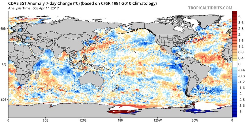
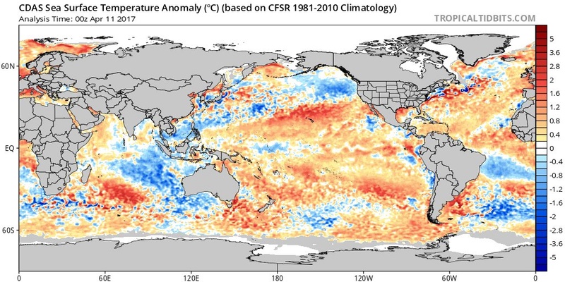
Have not looked on vacay but did notice this and interesting on the Nino front.
Major cooling off SA coast in 1.2 last in th last week.
Look at how cold the IO is. Going to interesting next 6 months on this shapes up. Look at all the cooling taking place in the PAC overall the last 7 days though it is still for Trump.majority Red as per SST, LOL!!
_________________
Mugs
AKA:King: Snow Weenie
Self Proclaimed
WINTER 2014-15 : 55.12" +.02 for 6 coatings (avg. 35")
WINTER 2015-16 Total - 29.8" (Avg 35")
WINTER 2016-17 : 39.5" so far

amugs- Advanced Forecaster - Mod

- Posts : 15095
Reputation : 213
Join date : 2013-01-07
Age : 54
Location : Hillsdale,NJ
Re: Long Range Thread 14.0
![]() by amugs Tue Apr 11, 2017 8:56 am
by amugs Tue Apr 11, 2017 8:56 am
Gfs has a clear dry day as of its 6Z run.sabamfa wrote:Anyone think next Friday (4.14) could be a nice day? Maybe mid-upper 60s and not raining? It's my wedding day =(
NNJ is about low end 60's.
_________________
Mugs
AKA:King: Snow Weenie
Self Proclaimed
WINTER 2014-15 : 55.12" +.02 for 6 coatings (avg. 35")
WINTER 2015-16 Total - 29.8" (Avg 35")
WINTER 2016-17 : 39.5" so far
amugs- Advanced Forecaster - Mod
- Posts : 15095
Reputation : 213
Join date : 2013-01-07
Age : 54
Location : Hillsdale,NJ
Re: Long Range Thread 14.0
![]() by sabamfa Tue Apr 11, 2017 5:56 pm
by sabamfa Tue Apr 11, 2017 5:56 pm
sabamfa- Pro Enthusiast
- Posts : 246
Reputation : 2
Join date : 2013-11-05
Age : 38
Location : Wayne, NJ
Re: Long Range Thread 14.0
![]() by Frank_Wx Wed Apr 12, 2017 9:08 pm
by Frank_Wx Wed Apr 12, 2017 9:08 pm
sabamfa wrote:Anyone think next Friday (4.14) could be a nice day? Maybe mid-upper 60s and not raining? It's my wedding day =(
I would argue perfect weather for a Wedding. Partly sunny with temps in the 60's. A big congrats to you!!!!!!
_________________
_______________________________________________________________________________________________________
CLICK HERE to view NJ Strong Snowstorm Classifications
Frank_Wx- Godzilla Seeker
- Posts : 21305
Reputation : 328
Join date : 2013-01-05
Age : 32
Location : Jersey City, NJ -
Re: Long Range Thread 14.0
![]() by Frank_Wx Wed Apr 12, 2017 9:09 pm
by Frank_Wx Wed Apr 12, 2017 9:09 pm
amugs wrote:Congrats on the big day!
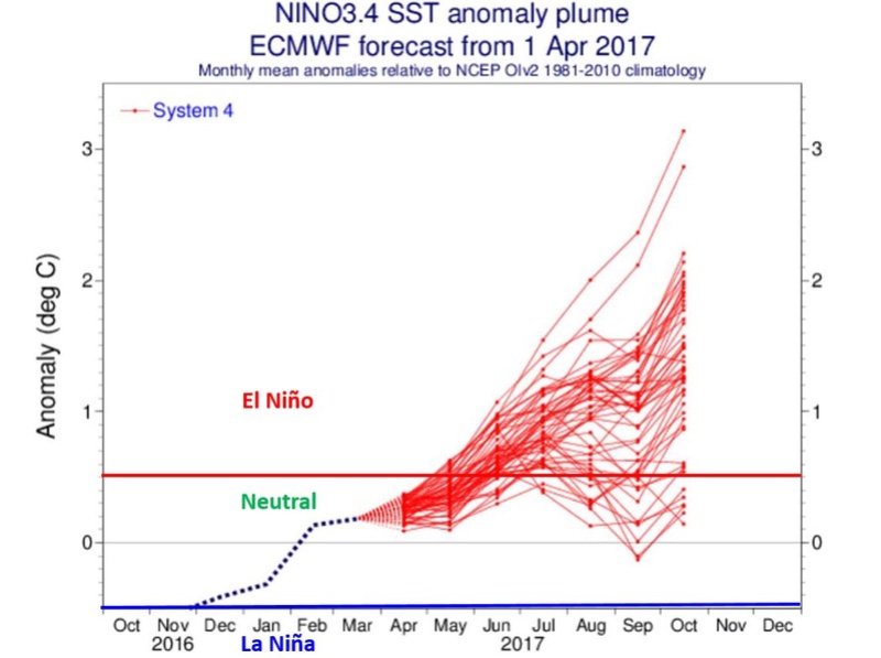
Have not looked on vacay but did notice this and interesting on the Nino front.
Major cooling off SA coast in 1.2 last in th last week.
Look at how cold the IO is. Going to interesting next 6 months on this shapes up. Look at all the cooling taking place in the PAC overall the last 7 days though it is still for Trump.majority Red as per SST, LOL!!
Statistical models are still pointing to a west-central based El Nino forming by summer.
I am for another Nino as long as it's in the weak-moderate levels.
_________________
_______________________________________________________________________________________________________
CLICK HERE to view NJ Strong Snowstorm Classifications
Frank_Wx- Godzilla Seeker
- Posts : 21305
Reputation : 328
Join date : 2013-01-05
Age : 32
Location : Jersey City, NJ -
Re: Long Range Thread 14.0
![]() by skinsfan1177 Thu Apr 13, 2017 8:03 pm
by skinsfan1177 Thu Apr 13, 2017 8:03 pm
Frank_Wx wrote:amugs wrote:Congrats on the big day!
Have not looked on vacay but did notice this and interesting on the Nino front.
Major cooling off SA coast in 1.2 last in th last week.
Look at how cold the IO is. Going to interesting next 6 months on this shapes up. Look at all the cooling taking place in the PAC overall the last 7 days though it is still for Trump.majority Red as per SST, LOL!!
Statistical models are still pointing to a west-central based El Nino forming by summer.
I am for another Nino as long as it's in the weak-moderate levels.
And what does this mean our area

skinsfan1177- Senior Enthusiast

- Posts : 4485
Reputation : 35
Join date : 2013-01-07
Age : 46
Location : Point Pleasant Boro
Re: Long Range Thread 14.0
![]() by amugs Sun Apr 16, 2017 12:22 pm
by amugs Sun Apr 16, 2017 12:22 pm
_________________
Mugs
AKA:King: Snow Weenie
Self Proclaimed
WINTER 2014-15 : 55.12" +.02 for 6 coatings (avg. 35")
WINTER 2015-16 Total - 29.8" (Avg 35")
WINTER 2016-17 : 39.5" so far
amugs- Advanced Forecaster - Mod
- Posts : 15095
Reputation : 213
Join date : 2013-01-07
Age : 54
Location : Hillsdale,NJ
Re: Long Range Thread 14.0
![]() by amugs Tue Apr 18, 2017 3:25 pm
by amugs Tue Apr 18, 2017 3:25 pm

_________________
Mugs
AKA:King: Snow Weenie
Self Proclaimed
WINTER 2014-15 : 55.12" +.02 for 6 coatings (avg. 35")
WINTER 2015-16 Total - 29.8" (Avg 35")
WINTER 2016-17 : 39.5" so far
amugs- Advanced Forecaster - Mod
- Posts : 15095
Reputation : 213
Join date : 2013-01-07
Age : 54
Location : Hillsdale,NJ
Re: Long Range Thread 14.0
![]() by nutleyblizzard Wed Apr 19, 2017 6:38 am
by nutleyblizzard Wed Apr 19, 2017 6:38 am
I think its a bit early to get excited about how this potential Nino may behave. Yes its a good sign but the timeline your talking about is still 6+ months away. Even so, if we get a weak/moderate Modoki event that does not necessarily make a great winter. Will the PDO be positive or negative? We need to see if the Atlantic cooperates. A lot of factors at play to make or break any given winter. Just keeping it real Mugs.amugs wrote:Nino saying a moderate to weak one incoming by late fall which would be wonderful news overall for us snow geese OR WEENIES!!

nutleyblizzard- Senior Enthusiast
- Posts : 1954
Reputation : 41
Join date : 2014-01-30
Age : 58
Location : Nutley, new jersey
Re: Long Range Thread 14.0
![]() by skinsfan1177 Wed Apr 19, 2017 9:06 am
by skinsfan1177 Wed Apr 19, 2017 9:06 am
nutleyblizzard wrote:I think its a bit early to get excited about how this potential Nino may behave. Yes its a good sign but the timeline your talking about is still 6+ months away. Even so, if we get a weak/moderate Modoki event that does not necessarily make a great winter. Will the PDO be positive or negative? We need to see if the Atlantic cooperates. A lot of factors at play to make or break any given winter. Just keeping it real Mugs.amugs wrote:Nino saying a moderate to weak one incoming by late fall which would be wonderful news overall for us snow geese OR WEENIES!!
I agree but I do see how mugs gets excited because its piece of the puzzle but also agree with you as well. Many factors to consider qbo and so on
skinsfan1177- Senior Enthusiast
- Posts : 4485
Reputation : 35
Join date : 2013-01-07
Age : 46
Location : Point Pleasant Boro
Re: Long Range Thread 14.0
![]() by pkmak Wed Apr 19, 2017 10:44 am
by pkmak Wed Apr 19, 2017 10:44 am
Thanks
pkmak- Posts : 27
Reputation : 0
Join date : 2013-08-30
Location : Glen Cove NY
Re: Long Range Thread 14.0
![]() by amugs Wed Apr 19, 2017 1:40 pm
by amugs Wed Apr 19, 2017 1:40 pm
nutleyblizzard wrote:I think its a bit early to get excited about how this potential Nino may behave. Yes its a good sign but the timeline your talking about is still 6+ months away. Even so, if we get a weak/moderate Modoki event that does not necessarily make a great winter. Will the PDO be positive or negative? We need to see if the Atlantic cooperates. A lot of factors at play to make or break any given winter. Just keeping it real Mugs.amugs wrote:Nino saying a moderate to weak one incoming by late fall which would be wonderful news overall for us snow geese OR WEENIES!!
Nuts i hear ya BUT this can be a driving force as we near the best season of all my weenie friend!
_________________
Mugs
AKA:King: Snow Weenie
Self Proclaimed
WINTER 2014-15 : 55.12" +.02 for 6 coatings (avg. 35")
WINTER 2015-16 Total - 29.8" (Avg 35")
WINTER 2016-17 : 39.5" so far
amugs- Advanced Forecaster - Mod
- Posts : 15095
Reputation : 213
Join date : 2013-01-07
Age : 54
Location : Hillsdale,NJ
Re: Long Range Thread 14.0
![]() by skinsfan1177 Thu Apr 20, 2017 7:21 am
by skinsfan1177 Thu Apr 20, 2017 7:21 am
skinsfan1177- Senior Enthusiast
- Posts : 4485
Reputation : 35
Join date : 2013-01-07
Age : 46
Location : Point Pleasant Boro
Re: Long Range Thread 14.0
![]() by Frank_Wx Thu Apr 20, 2017 7:55 am
by Frank_Wx Thu Apr 20, 2017 7:55 am
pkmak wrote:Frank, I am getting married as well this Friday the 21st in Westbury NY, I am hoping to have my cocktail hour outdoors starting at 6 pm, wondering if we will get rained on?
Thanks
Oh man, it looks unsettled unfortunately. I do not think you will see much in the way of rain but it will be cool and cloudy. But most models have rain ending by 4pm
skinsfan1177 wrote:In hearing warm temps next week anyone have info. Also Sunday may not be so wet
Yes.
Check out this southerly flow that develops on the GEFS by Tuesday

Then look how the ridge amplifies more by Saturday

_________________
_______________________________________________________________________________________________________
CLICK HERE to view NJ Strong Snowstorm Classifications
Frank_Wx- Godzilla Seeker
- Posts : 21305
Reputation : 328
Join date : 2013-01-05
Age : 32
Location : Jersey City, NJ -
Re: Long Range Thread 14.0
![]() by pkmak Thu Apr 20, 2017 8:57 am
by pkmak Thu Apr 20, 2017 8:57 am
pkmak- Posts : 27
Reputation : 0
Join date : 2013-08-30
Location : Glen Cove NY
Re: Long Range Thread 14.0
![]() by amugs Thu Apr 20, 2017 11:15 am
by amugs Thu Apr 20, 2017 11:15 am
Take this with a grain of salt but would love it IF it happens!!
SST
Modoki Nino

Air Temp Anomoly

Precip

_________________
Mugs
AKA:King: Snow Weenie
Self Proclaimed
WINTER 2014-15 : 55.12" +.02 for 6 coatings (avg. 35")
WINTER 2015-16 Total - 29.8" (Avg 35")
WINTER 2016-17 : 39.5" so far
amugs- Advanced Forecaster - Mod
- Posts : 15095
Reputation : 213
Join date : 2013-01-07
Age : 54
Location : Hillsdale,NJ
Re: Long Range Thread 14.0
![]() by amugs Thu Apr 20, 2017 11:15 am
by amugs Thu Apr 20, 2017 11:15 am

_________________
Mugs
AKA:King: Snow Weenie
Self Proclaimed
WINTER 2014-15 : 55.12" +.02 for 6 coatings (avg. 35")
WINTER 2015-16 Total - 29.8" (Avg 35")
WINTER 2016-17 : 39.5" so far
amugs- Advanced Forecaster - Mod
- Posts : 15095
Reputation : 213
Join date : 2013-01-07
Age : 54
Location : Hillsdale,NJ
Re: Long Range Thread 14.0
![]() by rb924119 Thu Apr 20, 2017 12:20 pm
by rb924119 Thu Apr 20, 2017 12:20 pm
amugs wrote:JUST for the weenie in all of us - T minus 6 Months and counting LOL!!
Take this with a grain of salt but would love it IF it happens!!
SST
Modoki Nino
Air Temp Anomoly
Precip

rb924119- Meteorologist
- Posts : 6928
Reputation : 194
Join date : 2013-02-06
Age : 32
Location : Greentown, Pa
Re: Long Range Thread 14.0
![]() by amugs Thu Apr 20, 2017 1:11 pm
by amugs Thu Apr 20, 2017 1:11 pm
Now look at this - IF this happened here next week people would poop their pants!


_________________
Mugs
AKA:King: Snow Weenie
Self Proclaimed
WINTER 2014-15 : 55.12" +.02 for 6 coatings (avg. 35")
WINTER 2015-16 Total - 29.8" (Avg 35")
WINTER 2016-17 : 39.5" so far
amugs- Advanced Forecaster - Mod
- Posts : 15095
Reputation : 213
Join date : 2013-01-07
Age : 54
Location : Hillsdale,NJ
Re: Long Range Thread 14.0
![]() by Math23x7 Thu Apr 20, 2017 1:51 pm
by Math23x7 Thu Apr 20, 2017 1:51 pm
amugs wrote:^^^^^^^^^^^^^RAY!!!!!!!!!!!!
Now look at this - IF this happened here next week people would poop their pants!
I beg to differ mugs. From April to early November, I welcome those temperature anomalies with open arms, just like how I welcomed the mid 80s this past Easter Sunday. 80s and sunshine FTW!
Math23x7- Wx Statistician Guru
- Posts : 2379
Reputation : 68
Join date : 2013-01-08
Re: Long Range Thread 14.0
![]() by Frank_Wx Thu Apr 20, 2017 2:22 pm
by Frank_Wx Thu Apr 20, 2017 2:22 pm
...said no one ever
_________________
_______________________________________________________________________________________________________
CLICK HERE to view NJ Strong Snowstorm Classifications
Frank_Wx- Godzilla Seeker
- Posts : 21305
Reputation : 328
Join date : 2013-01-05
Age : 32
Location : Jersey City, NJ -
Re: Long Range Thread 14.0
![]() by frank 638 Thu Apr 20, 2017 2:30 pm
by frank 638 Thu Apr 20, 2017 2:30 pm
frank 638- Senior Enthusiast
- Posts : 2843
Reputation : 37
Join date : 2016-01-01
Age : 40
Location : bronx ny
Re: Long Range Thread 14.0
![]() by rb924119 Thu Apr 20, 2017 5:53 pm
by rb924119 Thu Apr 20, 2017 5:53 pm
amugs wrote:^^^^^^^^^^^^^RAY!!!!!!!!!!!!
Now look at this - IF this happened here next week people would poop their pants!
It's going to happen mugs. I think the end of next week could offer a borderline heat wave for some IF THE FULL POTENTIAL IS REALIZED. Check out Easter 1976; identical analog. Just saying lol with the way the Hemispheric pattern is looking to shape up during that period, we should have a huge surge of warmth through the East, and given the previous tendencies to over achieve so far this year, I think argues strongly for widespread 70s, 80s, and even approaching 90, again, if potential is maximized.
rb924119- Meteorologist
- Posts : 6928
Reputation : 194
Join date : 2013-02-06
Age : 32
Location : Greentown, Pa
Page 13 of 14 • 1 ... 8 ... 12, 13, 14 ![]()
|
|
|