
 Search
BLOG: Roidzilla Could Impact Area Tuesday March 14th
Page 3 of 25 •  1, 2, 3, 4 ... 14 ... 25
 ![]()

SoulSingMG- Senior Enthusiast

- Posts : 2853
Join date : 2013-12-11
Re: BLOG: Roidzilla Could Impact Area Tuesday March 14th
![]() by jmanley32 Fri Mar 10, 2017 1:49 am
by jmanley32 Fri Mar 10, 2017 1:49 am
wow!! Roidzilla? It could b a bit closer but not much. I'd appreciate a snow and max wind map if u can. Can't pay for wxbell right now.SoulSingMG wrote:
jmanley32- Senior Enthusiast
- Posts : 20535
Join date : 2013-12-12
Re: BLOG: Roidzilla Could Impact Area Tuesday March 14th
![]() by jmanley32 Fri Mar 10, 2017 1:58 am
by jmanley32 Fri Mar 10, 2017 1:58 am

jmanley32- Senior Enthusiast
- Posts : 20535
Reputation : 108
Join date : 2013-12-12
Age : 43
Location : Yonkers, NY
Re: BLOG: Roidzilla Could Impact Area Tuesday March 14th
![]() by SNOW MAN Fri Mar 10, 2017 5:26 am
by SNOW MAN Fri Mar 10, 2017 5:26 am
SoulSingMG wrote:EURO IS ABOUT TO BLOW US ALL TO SNOWBLIVION!
This made me bust out laughing ! This is GREAT !


SNOW MAN- Senior Enthusiast
- Posts : 1361
Reputation : 25
Join date : 2013-01-13
Age : 64
Location : Marshalls Creek Pa.
Re: BLOG: Roidzilla Could Impact Area Tuesday March 14th
![]() by Frank_Wx Fri Mar 10, 2017 6:11 am
by Frank_Wx Fri Mar 10, 2017 6:11 am

_________________
_______________________________________________________________________________________________________
CLICK HERE to view NJ Strong Snowstorm Classifications

Frank_Wx- Godzilla Seeker

- Posts : 21305
Reputation : 328
Join date : 2013-01-05
Age : 32
Location : Jersey City, NJ -

Re: BLOG: Roidzilla Could Impact Area Tuesday March 14th
![]() by weatherwatchermom Fri Mar 10, 2017 6:14 am
by weatherwatchermom Fri Mar 10, 2017 6:14 am
fell asleep early last night just woke up to catch up. Have to say I love your late night shout outs ..SoulSingMG wrote:EURO IS ABOUT TO BLOW US ALL TO SNOWBLIVION!
now I will continue reading..
weatherwatchermom- Senior Enthusiast
- Posts : 3793
Reputation : 78
Join date : 2014-11-25
Location : Hazlet Township, NJ
Re: BLOG: Roidzilla Could Impact Area Tuesday March 14th
![]() by SENJsnowman Fri Mar 10, 2017 6:31 am
by SENJsnowman Fri Mar 10, 2017 6:31 am
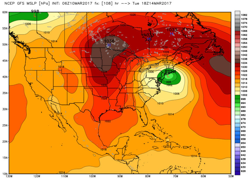
Frank_Wx wrote:Euro ensembles
Given the past few runs, no complaints here. Still need a slight push east. That GFS though...
SENJsnowman- Senior Enthusiast
- Posts : 1189
Reputation : 61
Join date : 2017-01-06
Age : 51
Location : Bayville, NJ
Re: BLOG: Roidzilla Could Impact Area Tuesday March 14th
![]() by sroc4 Fri Mar 10, 2017 6:38 am
by sroc4 Fri Mar 10, 2017 6:38 am

_________________
"In weather and in life, there's no winning and losing; there's only winning and learning."
WINTER 2012/2013 TOTALS 43.65"WINTER 2017/2018 TOTALS 62.85" WINTER 2022/2023 TOTALS 4.9"
WINTER 2013/2014 TOTALS 64.85"WINTER 2018/2019 TOTALS 14.25" WINTER 2023/2024 TOTALS 13.1"
WINTER 2014/2015 TOTALS 71.20"WINTER 2019/2020 TOTALS 6.35"
WINTER 2015/2016 TOTALS 35.00"WINTER 2020/2021 TOTALS 37.75"
WINTER 2016/2017 TOTALS 42.25"WINTER 2021/2022 TOTALS 31.65"

sroc4- Admin
- Posts : 8354
Reputation : 302
Join date : 2013-01-07
Location : Wading River, LI
Re: BLOG: Roidzilla Could Impact Area Tuesday March 14th
![]() by SENJsnowman Fri Mar 10, 2017 6:49 am
by SENJsnowman Fri Mar 10, 2017 6:49 am
sroc4 wrote:Frank great write up!! Not a lot to add to the discussion this morning except to say we def sit in a decent position right now. I wouldn't worry too much right now about the GFS hugging the coast, although this is possible. Its own Ensemble mean is east as is the euro op and its ensemble mean. GFS Op is the outlier for now. Avg the differences and we are looking good right now.
Very comforting words for us Coasties! Let's hope...and track!
Frank, that write up was superb...and thank you for including so many fundamental explanations for novices like me...much appreciated!
SENJsnowman- Senior Enthusiast
- Posts : 1189
Reputation : 61
Join date : 2017-01-06
Age : 51
Location : Bayville, NJ
Re: BLOG: Roidzilla Could Impact Area Tuesday March 14th
![]() by nutleyblizzard Fri Mar 10, 2017 6:58 am
by nutleyblizzard Fri Mar 10, 2017 6:58 am

nutleyblizzard- Senior Enthusiast
- Posts : 1954
Reputation : 41
Join date : 2014-01-30
Age : 58
Location : Nutley, new jersey
Re: BLOG: Roidzilla Could Impact Area Tuesday March 14th
![]() by sroc4 Fri Mar 10, 2017 7:03 am
by sroc4 Fri Mar 10, 2017 7:03 am
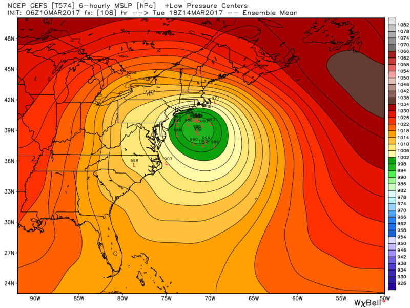
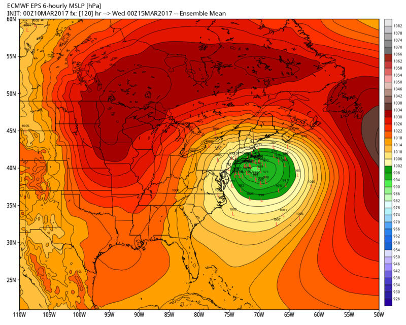
nutleyblizzard wrote:EPS is downright impressive. Some the indies get down to the 960's. Once today's event gets out of the way, we will start to get a consensus with track. Sunday's 12z runs should tell the tale. My gut tells me this takes a track just inside the benchmark.
That's a fair assessment at this point Nutz. Looking at the image I posted above the EPS mean is literally on the BM.
_________________
"In weather and in life, there's no winning and losing; there's only winning and learning."
WINTER 2012/2013 TOTALS 43.65"WINTER 2017/2018 TOTALS 62.85" WINTER 2022/2023 TOTALS 4.9"
WINTER 2013/2014 TOTALS 64.85"WINTER 2018/2019 TOTALS 14.25" WINTER 2023/2024 TOTALS 13.1"
WINTER 2014/2015 TOTALS 71.20"WINTER 2019/2020 TOTALS 6.35"
WINTER 2015/2016 TOTALS 35.00"WINTER 2020/2021 TOTALS 37.75"
WINTER 2016/2017 TOTALS 42.25"WINTER 2021/2022 TOTALS 31.65"
sroc4- Admin
- Posts : 8354
Reputation : 302
Join date : 2013-01-07
Location : Wading River, LI
Re: BLOG: Roidzilla Could Impact Area Tuesday March 14th
![]() by SENJsnowman Fri Mar 10, 2017 7:11 am
by SENJsnowman Fri Mar 10, 2017 7:11 am
sroc4 wrote:nutleyblizzard wrote:EPS is downright impressive. Some the indies get down to the 960's. Once today's event gets out of the way, we will start to get a consensus with track. Sunday's 12z runs should tell the tale. My gut tells me this takes a track just inside the benchmark.
That's a fair assessment at this point Nutz. Looking at the image I posted above the EPS mean is literally on the BM.
OK, I did my homework, and now I know exactly what the BM is and what is means generally speaking. Where would I want the track realtive to the BM to get max snowfall and no rain for the Jersey Shore? I figure that the dynamics of each storm make a difference, but typically...on it? Just west? Just east?
SENJsnowman- Senior Enthusiast
- Posts : 1189
Reputation : 61
Join date : 2017-01-06
Age : 51
Location : Bayville, NJ
Re: BLOG: Roidzilla Could Impact Area Tuesday March 14th
![]() by sroc4 Fri Mar 10, 2017 7:19 am
by sroc4 Fri Mar 10, 2017 7:19 am
SENJsnowman wrote:sroc4 wrote:nutleyblizzard wrote:EPS is downright impressive. Some the indies get down to the 960's. Once today's event gets out of the way, we will start to get a consensus with track. Sunday's 12z runs should tell the tale. My gut tells me this takes a track just inside the benchmark.
That's a fair assessment at this point Nutz. Looking at the image I posted above the EPS mean is literally on the BM.
OK, I did my homework, and now I know exactly what the BM is and what is means generally speaking. Where would I want the track realtive to the BM to get max snowfall and no rain for the Jersey Shore? I figure that the dynamics of each storm make a difference, but typically...on it? Just west? Just east?
For yuo a track on or just SE of the BM is usually ideal.
_________________
"In weather and in life, there's no winning and losing; there's only winning and learning."
WINTER 2012/2013 TOTALS 43.65"WINTER 2017/2018 TOTALS 62.85" WINTER 2022/2023 TOTALS 4.9"
WINTER 2013/2014 TOTALS 64.85"WINTER 2018/2019 TOTALS 14.25" WINTER 2023/2024 TOTALS 13.1"
WINTER 2014/2015 TOTALS 71.20"WINTER 2019/2020 TOTALS 6.35"
WINTER 2015/2016 TOTALS 35.00"WINTER 2020/2021 TOTALS 37.75"
WINTER 2016/2017 TOTALS 42.25"WINTER 2021/2022 TOTALS 31.65"
sroc4- Admin
- Posts : 8354
Reputation : 302
Join date : 2013-01-07
Location : Wading River, LI
Re: BLOG: Roidzilla Could Impact Area Tuesday March 14th
![]() by jmanley32 Fri Mar 10, 2017 7:20 am
by jmanley32 Fri Mar 10, 2017 7:20 am
jmanley32- Senior Enthusiast
- Posts : 20535
Reputation : 108
Join date : 2013-12-12
Age : 43
Location : Yonkers, NY
Re: BLOG: Roidzilla Could Impact Area Tuesday March 14th
![]() by jmanley32 Fri Mar 10, 2017 7:22 am
by jmanley32 Fri Mar 10, 2017 7:22 am
that's an incredibly high mean I'd love to see the indies if someone can get a chance to post them.SENJsnowman wrote:Frank_Wx wrote:Euro ensembles
Given the past few runs, no complaints here. Still need a slight push east. That GFS though...
jmanley32- Senior Enthusiast
- Posts : 20535
Reputation : 108
Join date : 2013-12-12
Age : 43
Location : Yonkers, NY
Re: BLOG: Roidzilla Could Impact Area Tuesday March 14th
![]() by billg315 Fri Mar 10, 2017 7:35 am
by billg315 Fri Mar 10, 2017 7:35 am

billg315- Advanced Forecaster - Mod

- Posts : 4483
Reputation : 185
Join date : 2015-01-24
Age : 50
Location : Flemington, NJ
Re: BLOG: Roidzilla Could Impact Area Tuesday March 14th
![]() by Guest Fri Mar 10, 2017 7:38 am
by Guest Fri Mar 10, 2017 7:38 am
Guest- Guest
Re: BLOG: Roidzilla Could Impact Area Tuesday March 14th
![]() by billg315 Fri Mar 10, 2017 7:42 am
by billg315 Fri Mar 10, 2017 7:42 am
billg315- Advanced Forecaster - Mod
- Posts : 4483
Reputation : 185
Join date : 2015-01-24
Age : 50
Location : Flemington, NJ
Re: BLOG: Roidzilla Could Impact Area Tuesday March 14th
![]() by Frank_Wx Fri Mar 10, 2017 7:45 am
by Frank_Wx Fri Mar 10, 2017 7:45 am

_________________
_______________________________________________________________________________________________________
CLICK HERE to view NJ Strong Snowstorm Classifications
Frank_Wx- Godzilla Seeker
- Posts : 21305
Reputation : 328
Join date : 2013-01-05
Age : 32
Location : Jersey City, NJ -
Re: BLOG: Roidzilla Could Impact Area Tuesday March 14th
![]() by SNOW MAN Fri Mar 10, 2017 7:51 am
by SNOW MAN Fri Mar 10, 2017 7:51 am
SNOW MAN- Senior Enthusiast
- Posts : 1361
Reputation : 25
Join date : 2013-01-13
Age : 64
Location : Marshalls Creek Pa.
Re: BLOG: Roidzilla Could Impact Area Tuesday March 14th
![]() by sroc4 Fri Mar 10, 2017 7:54 am
by sroc4 Fri Mar 10, 2017 7:54 am
_________________
"In weather and in life, there's no winning and losing; there's only winning and learning."
WINTER 2012/2013 TOTALS 43.65"WINTER 2017/2018 TOTALS 62.85" WINTER 2022/2023 TOTALS 4.9"
WINTER 2013/2014 TOTALS 64.85"WINTER 2018/2019 TOTALS 14.25" WINTER 2023/2024 TOTALS 13.1"
WINTER 2014/2015 TOTALS 71.20"WINTER 2019/2020 TOTALS 6.35"
WINTER 2015/2016 TOTALS 35.00"WINTER 2020/2021 TOTALS 37.75"
WINTER 2016/2017 TOTALS 42.25"WINTER 2021/2022 TOTALS 31.65"
sroc4- Admin
- Posts : 8354
Reputation : 302
Join date : 2013-01-07
Location : Wading River, LI
Re: BLOG: Roidzilla Could Impact Area Tuesday March 14th
![]() by SNOW MAN Fri Mar 10, 2017 7:56 am
by SNOW MAN Fri Mar 10, 2017 7:56 am
sroc4 wrote:Funny thing about this upcoming potential. I am supposed to fly out on Wed to Savannah Georgia for a golf trip and party for St Patty's day with the boys.
Will you stay or go ?
SNOW MAN- Senior Enthusiast
- Posts : 1361
Reputation : 25
Join date : 2013-01-13
Age : 64
Location : Marshalls Creek Pa.
Re: BLOG: Roidzilla Could Impact Area Tuesday March 14th
![]() by sroc4 Fri Mar 10, 2017 7:57 am
by sroc4 Fri Mar 10, 2017 7:57 am
SNOW MAN wrote:sroc4 wrote:Funny thing about this upcoming potential. I am supposed to fly out on Wed to Savannah Georgia for a golf trip and party for St Patty's day with the boys.
Will you stay or go ?
Well flight is 3:40pm Wednesday. If I have to drive I'm going!! LOL
_________________
"In weather and in life, there's no winning and losing; there's only winning and learning."
WINTER 2012/2013 TOTALS 43.65"WINTER 2017/2018 TOTALS 62.85" WINTER 2022/2023 TOTALS 4.9"
WINTER 2013/2014 TOTALS 64.85"WINTER 2018/2019 TOTALS 14.25" WINTER 2023/2024 TOTALS 13.1"
WINTER 2014/2015 TOTALS 71.20"WINTER 2019/2020 TOTALS 6.35"
WINTER 2015/2016 TOTALS 35.00"WINTER 2020/2021 TOTALS 37.75"
WINTER 2016/2017 TOTALS 42.25"WINTER 2021/2022 TOTALS 31.65"
sroc4- Admin
- Posts : 8354
Reputation : 302
Join date : 2013-01-07
Location : Wading River, LI
Re: BLOG: Roidzilla Could Impact Area Tuesday March 14th
![]() by nutleyblizzard Fri Mar 10, 2017 8:09 am
by nutleyblizzard Fri Mar 10, 2017 8:09 am
While still a possible scenario, I think the GFS is too far west and will correct east in time. EURO is a little to far east for my liking. Rooting hard for a UKMET track!!!Frank_Wx wrote:UKIE and EURO are the best models inside 120 hours and they both show a Roidzilla at the moment. So...
nutleyblizzard- Senior Enthusiast
- Posts : 1954
Reputation : 41
Join date : 2014-01-30
Age : 58
Location : Nutley, new jersey
Re: BLOG: Roidzilla Could Impact Area Tuesday March 14th
![]() by mwilli5783 Fri Mar 10, 2017 8:18 am
by mwilli5783 Fri Mar 10, 2017 8:18 am
mwilli5783- Posts : 146
Reputation : 9
Join date : 2013-01-23
Age : 69
Location : hempstead n.y
Re: BLOG: Roidzilla Could Impact Area Tuesday March 14th
![]() by jmanley32 Fri Mar 10, 2017 8:26 am
by jmanley32 Fri Mar 10, 2017 8:26 am
There is no longer a Sunday storm, that went poof, might have been models sniffing out tuesday. Which will likely be a big deal, maybe a major deal. People are complacent up here, especially after so many 60 degree days. Just be prepared for last minute craze i feel bad for you working at target for that.mwilli5783 wrote:people at my job (target in westbury l.i)don't think tuesday is gonna be a big deal,i tell them that fridays and sundays storms are like the appitizer to the main course come tuesday....stubborn people i guess
jmanley32- Senior Enthusiast
- Posts : 20535
Reputation : 108
Join date : 2013-12-12
Age : 43
Location : Yonkers, NY
Re: BLOG: Roidzilla Could Impact Area Tuesday March 14th
![]() by jmanley32 Fri Mar 10, 2017 8:27 am
by jmanley32 Fri Mar 10, 2017 8:27 am
jmanley32- Senior Enthusiast
- Posts : 20535
Reputation : 108
Join date : 2013-12-12
Age : 43
Location : Yonkers, NY
Page 3 of 25 • 1, 2, 3, 4 ... 14 ... 25 ![]()
|
|
|