
 Search
March 14, 2017 Roidzilla 1st Call Snow Map / Synopsis
Page 27 of 33 •  1 ... 15 ... 26, 27, 28 ... 33
 ![]()
Re: March 14, 2017 Roidzilla 1st Call Snow Map / Synopsis
![]() by nutleyblizzard Mon Mar 13, 2017 2:36 pm
by nutleyblizzard Mon Mar 13, 2017 2:36 pm
We are going to need lots of updates on current low pressure mesoscale maps thats for sure. Amazingly I still receive 18+ on the EURO where Im at in essex county. I will be praying big time tomorrow Im able to stay away from pingers and that dreaded dry slot.Frank_Wx wrote:Nowcasting is going to be really fun. Is the SLP following a GFS or EURO esque track? That will be the $$$$$$$$$ question.
nutleyblizzard- Senior Enthusiast

- Posts : 1952
Join date : 2014-01-30
Re: March 14, 2017 Roidzilla 1st Call Snow Map / Synopsis
![]() by Frank_Wx Mon Mar 13, 2017 2:38 pm
by Frank_Wx Mon Mar 13, 2017 2:38 pm
syosnow94 wrote:Big win for the NAM which a lot of people wanted to toss because it showed a coastal hugger, and huge screw job for all areas s and e of NYC who went from a "triple phasing BECS" to a run of the mill noreaster for us. N and W of 5 boroughs CONGRATULATIONS!!
Please stop. Here is your NAM from 3 days ago. The low is 1000mb and over NJ. Not even an inch of snow for LI. Nowhere near close to what will happen.

Frank_Wx- Godzilla Seeker

- Posts : 21305
Join date : 2013-01-05 -

Re: March 14, 2017 Roidzilla 1st Call Snow Map / Synopsis
![]() by Guest Mon Mar 13, 2017 2:39 pm
by Guest Mon Mar 13, 2017 2:39 pm
Guest- Guest
Re: March 14, 2017 Roidzilla 1st Call Snow Map / Synopsis
![]() by Frank_Wx Mon Mar 13, 2017 2:39 pm
by Frank_Wx Mon Mar 13, 2017 2:39 pm

_________________
_______________________________________________________________________________________________________
CLICK HERE to view NJ Strong Snowstorm Classifications

Frank_Wx- Godzilla Seeker
- Posts : 21305
Reputation : 328
Join date : 2013-01-05
Age : 31
Location : Jersey City, NJ -
Re: March 14, 2017 Roidzilla 1st Call Snow Map / Synopsis
![]() by Frank_Wx Mon Mar 13, 2017 2:41 pm
by Frank_Wx Mon Mar 13, 2017 2:41 pm

_________________
_______________________________________________________________________________________________________
CLICK HERE to view NJ Strong Snowstorm Classifications
Frank_Wx- Godzilla Seeker
- Posts : 21305
Reputation : 328
Join date : 2013-01-05
Age : 31
Location : Jersey City, NJ -
Re: March 14, 2017 Roidzilla 1st Call Snow Map / Synopsis
![]() by Frank_Wx Mon Mar 13, 2017 2:42 pm
by Frank_Wx Mon Mar 13, 2017 2:42 pm
If the surface low takes a track west of Virginia Beach, it will hug the coast. If it tracks east of Virginia Beach, it will stay east and trend more toward the BM.
SO...KEEP AN EYE OUT FOR VA BEACH
_________________
_______________________________________________________________________________________________________
CLICK HERE to view NJ Strong Snowstorm Classifications
Frank_Wx- Godzilla Seeker
- Posts : 21305
Reputation : 328
Join date : 2013-01-05
Age : 31
Location : Jersey City, NJ -
Re: March 14, 2017 Roidzilla 1st Call Snow Map / Synopsis
![]() by SoulSingMG Mon Mar 13, 2017 2:43 pm
by SoulSingMG Mon Mar 13, 2017 2:43 pm

SoulSingMG- Senior Enthusiast
- Posts : 2853
Reputation : 74
Join date : 2013-12-11
Location : Long Island City, NY
Re: March 14, 2017 Roidzilla 1st Call Snow Map / Synopsis
![]() by Snow88 Mon Mar 13, 2017 2:44 pm
by Snow88 Mon Mar 13, 2017 2:44 pm
WOW

Snow88- Senior Enthusiast
- Posts : 2193
Reputation : 4
Join date : 2013-01-09
Age : 35
Location : Brooklyn, NY
Re: March 14, 2017 Roidzilla 1st Call Snow Map / Synopsis
![]() by Snow88 Mon Mar 13, 2017 2:47 pm
by Snow88 Mon Mar 13, 2017 2:47 pm
WOW LMFAO
Snow88- Senior Enthusiast
- Posts : 2193
Reputation : 4
Join date : 2013-01-09
Age : 35
Location : Brooklyn, NY
Re: March 14, 2017 Roidzilla 1st Call Snow Map / Synopsis
![]() by RJB8525 Mon Mar 13, 2017 2:48 pm
by RJB8525 Mon Mar 13, 2017 2:48 pm
Snow88 wrote:People are depressed over 12 inches of snow in March?
WOW LMFAO
lol i've been reading some crazy stuff..

RJB8525- Senior Enthusiast
- Posts : 1994
Reputation : 28
Join date : 2013-02-06
Age : 38
Location : Hackettstown, NJ
Re: March 14, 2017 Roidzilla 1st Call Snow Map / Synopsis
![]() by jake732 Mon Mar 13, 2017 2:49 pm
by jake732 Mon Mar 13, 2017 2:49 pm
Snow88 wrote:People are depressed over 12 inches of snow in March?
WOW LMFAO
yes im depressed over 2 inches

jake732- Pro Enthusiast

- Posts : 449
Reputation : 0
Join date : 2016-01-03
Location : lakewood, nj -
Re: March 14, 2017 Roidzilla 1st Call Snow Map / Synopsis
![]() by GreyBeard Mon Mar 13, 2017 2:49 pm
by GreyBeard Mon Mar 13, 2017 2:49 pm
Frank_Wx wrote:GreyBeard wrote:So it's set in stone now, or is there still some adjustments possible? I thought you weren't supposed to live or die by any one model run, but that's quite a change from this morning's outlook.
It's more than one model run at this point, and the upper level jet streak structure supports a tucked in track. I would love to see a jog east of 20 miles so more people cash in, and it's possible, but we have to nowcast.
Ok then, thanks for the explaining.
GreyBeard- Senior Enthusiast
- Posts : 725
Reputation : 34
Join date : 2014-02-12
Location : eastern nassau county
Re: March 14, 2017 Roidzilla 1st Call Snow Map / Synopsis
![]() by amugs Mon Mar 13, 2017 2:50 pm
by amugs Mon Mar 13, 2017 2:50 pm
Frank_Wx wrote:syosnow94 wrote:Big win for the NAM which a lot of people wanted to toss because it showed a coastal hugger, and huge screw job for all areas s and e of NYC who went from a "triple phasing BECS" to a run of the mill noreaster for us. N and W of 5 boroughs CONGRATULATIONS!!
Please stop. Here is your NAM from 3 days ago. The low is 1000mb and over NJ. Not even an inch of snow for LI. Nowhere near close to what will happen.
THANK YOU !!
SYO - THANKS FOR CONGRATULATING US BUDDY. WE'LL TAKE PICTURES AND VIDEO AND POST FOR YOU - HECK A 25 MILE TICK EAST AND YUO WILL BE GOOD AS WELL.
_________________
Mugs
AKA:King: Snow Weenie
Self Proclaimed
WINTER 2014-15 : 55.12" +.02 for 6 coatings (avg. 35")
WINTER 2015-16 Total - 29.8" (Avg 35")
WINTER 2016-17 : 39.5" so far

amugs- Advanced Forecaster - Mod

- Posts : 15093
Reputation : 213
Join date : 2013-01-07
Age : 54
Location : Hillsdale,NJ
Re: March 14, 2017 Roidzilla 1st Call Snow Map / Synopsis
![]() by aiannone Mon Mar 13, 2017 2:52 pm
by aiannone Mon Mar 13, 2017 2:52 pm
Frank_Wx wrote:850mb temps on EURO
Hmmm, that is concerning for the coast, but something tells me, we will have the 30mi tick east that you guys need
_________________
-Alex Iannone-

aiannone- Senior Enthusiast - Mod
- Posts : 4814
Reputation : 92
Join date : 2013-01-07
Location : Saint James, LI (Northwest Suffolk Co.)
Re: March 14, 2017 Roidzilla 1st Call Snow Map / Synopsis
![]() by nujerzeedevil Mon Mar 13, 2017 2:56 pm
by nujerzeedevil Mon Mar 13, 2017 2:56 pm
From your lips to the weather god's ears....aiannone wrote:Frank_Wx wrote:850mb temps on EURO
Hmmm, that is concerning for the coast, but something tells me, we will have the 30mi tick east that you guys need

nujerzeedevil- Posts : 121
Reputation : 14
Join date : 2013-12-30
Location : Bayville, NJ
Re: March 14, 2017 Roidzilla 1st Call Snow Map / Synopsis
![]() by Guest Mon Mar 13, 2017 2:56 pm
by Guest Mon Mar 13, 2017 2:56 pm
Guest- Guest
Re: March 14, 2017 Roidzilla 1st Call Snow Map / Synopsis
![]() by rb924119 Mon Mar 13, 2017 2:57 pm
by rb924119 Mon Mar 13, 2017 2:57 pm

Start: 11pm tonight to 3am tomorrow, for most, a couple hours before and after sunrise across southern and central New England.
End: Tuesday afternoon to evening, depending on where you are (, early-afternoon coastal plain), late-afternoon eastern Pa/NY, evening rest of New England)
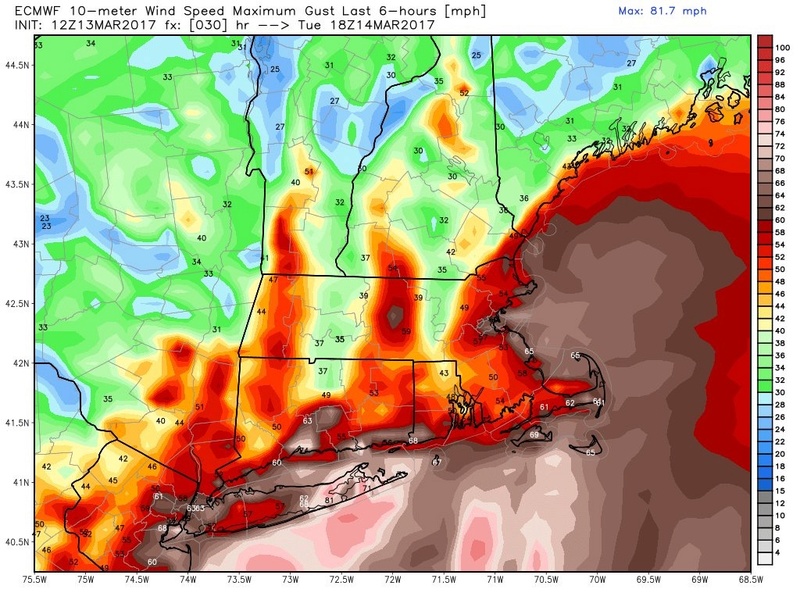
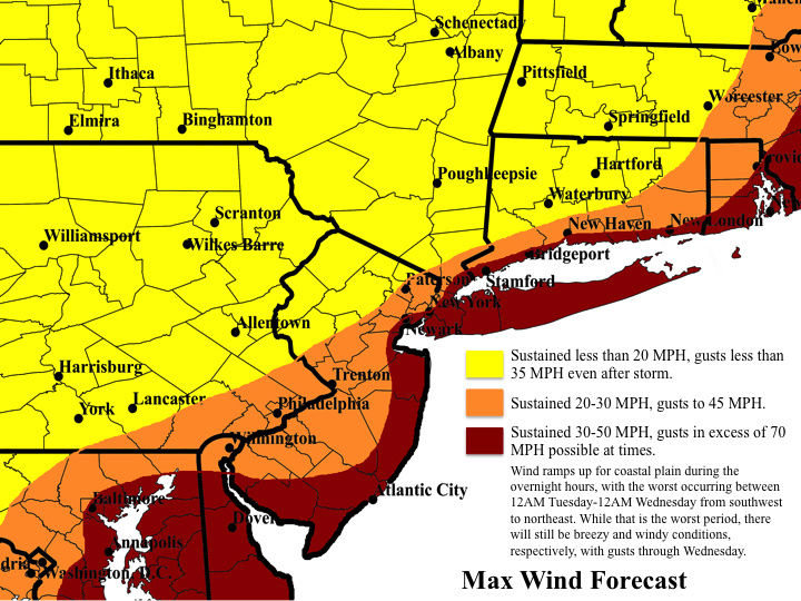
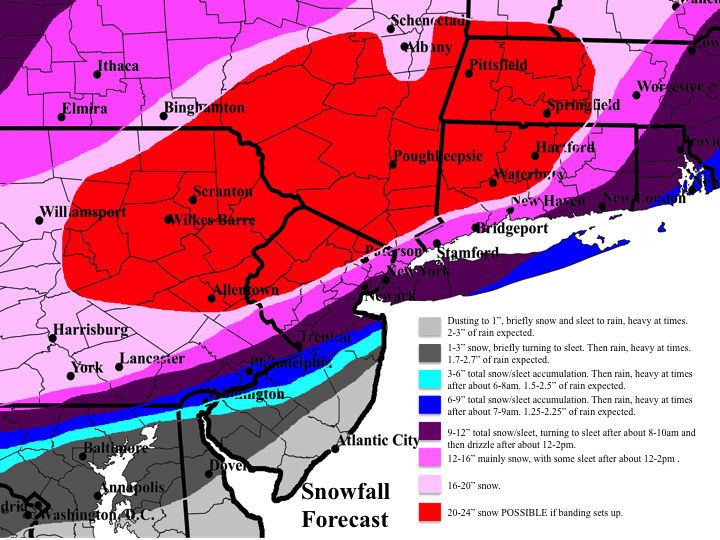
See the maps for the initial thoughts above, but I generally followed a blend of the NAM, SREF, RGEM, UKMET, and EURO suites, although with much less QPF. Unfortunately, I do not have time to go into detail as to why I chose these models and backed off on QPF, but the lack of confluence to the northeast of our system will allow this to be in and out in roughly 12 hours. To get more than 2 feet out of it in that time will be very tough in my opinion, even with ratios, when you take into account time lost to saturate the column and the winding down of the snowfall toward the end. That said, this will still be a very impactful system with extremely heavy snowfall rates at times, making travel nearly impossible, and lowering visibilities to near zero even without any help from wind. As you can see, though, I am expecting the surge of warm air to win out at least for a time along and east of the I-95 corridor. I have several reasons for this, but I do not have time to explain now. Minor to moderate coastal flooding is also expected with astronomical high tides overlapping with the wind and 2-4' storm surge, so coastal communities should be prepared for that. Also. beach erosion will be bad yet again. Sorry for the lack of a post, but I have to get ready for work! Enjoy your afternoons, everybody, and I will return this evening for continued discussion and any updates to my first call!!
Last edited by rb924119 on Mon Mar 13, 2017 3:05 pm; edited 1 time in total
rb924119- Meteorologist

- Posts : 6890
Reputation : 194
Join date : 2013-02-06
Age : 32
Location : Greentown, Pa
Re: March 14, 2017 Roidzilla 1st Call Snow Map / Synopsis
![]() by nujerzeedevil Mon Mar 13, 2017 2:58 pm
by nujerzeedevil Mon Mar 13, 2017 2:58 pm
nujerzeedevil wrote:Frank what are the chances that this sucker could still jog to the East? It looks to me like a 20-30 mile shift is the difference between me getting nothing to 8"+
Yes, a 30 mile difference will mean the world to some people. We just have to nowcast. There is not much I can say.
We'll just have to wait and see and pray for an eastern tick. Thank you as always sir....
nujerzeedevil- Posts : 121
Reputation : 14
Join date : 2013-12-30
Location : Bayville, NJ
Re: March 14, 2017 Roidzilla 1st Call Snow Map / Synopsis
![]() by Guest Mon Mar 13, 2017 3:00 pm
by Guest Mon Mar 13, 2017 3:00 pm
Guest- Guest
Re: March 14, 2017 Roidzilla 1st Call Snow Map / Synopsis
![]() by nutleyblizzard Mon Mar 13, 2017 3:01 pm
by nutleyblizzard Mon Mar 13, 2017 3:01 pm
I just looked over the last run of the NAM. Has the low east of Virginia Beach at 12z tomorrow morning (7am). Tomorrow morning could be telling.Frank_Wx wrote:Bastardi has a good rule of thumb that I like to use:
If the surface low takes a track west of Virginia Beach, it will hug the coast. If it tracks east of Virginia Beach, it will stay east and trend more toward the BM.
SO...KEEP AN EYE OUT FOR VA BEACH

nutleyblizzard- Senior Enthusiast
- Posts : 1952
Reputation : 41
Join date : 2014-01-30
Age : 58
Location : Nutley, new jersey
Re: March 14, 2017 Roidzilla 1st Call Snow Map / Synopsis
![]() by Guest Mon Mar 13, 2017 3:04 pm
by Guest Mon Mar 13, 2017 3:04 pm
Guest- Guest
Re: March 14, 2017 Roidzilla 1st Call Snow Map / Synopsis
![]() by RJB8525 Mon Mar 13, 2017 3:04 pm
by RJB8525 Mon Mar 13, 2017 3:04 pm
NJZ001-007>010-PAZ054-055-060>062-101-103-105-140615-
/O.UPG.KPHI.WS.W.0003.170314T0000Z-170314T2200Z/
/O.EXA.KPHI.BZ.W.0001.170314T0000Z-170314T2200Z/
Sussex-Warren-Morris-Hunterdon-Somerset-Carbon-Monroe-Berks-
Lehigh-Northampton-Western Chester-Western Montgomery-Upper Bucks-
Including the cities of Newton, Washington, Morristown,
Flemington, Somerville, Jim Thorpe, Stroudsburg, Reading,
Allentown, Bethlehem, Easton, Honey Brook, Oxford, Collegeville,
Pottstown, Chalfont, and Perkasie
300 PM EDT Mon Mar 13 2017
...BLIZZARD WARNING IN EFFECT FROM 8 PM THIS EVENING TO 6 PM EDT
TUESDAY...
The National Weather Service in Mount Holly has issued a Blizzard
Warning, which is in effect from 8 PM this evening to 6 PM EDT
Tuesday. The Winter Storm Warning is no longer in effect.
* LOCATIONS...Eastern Pennsylvania and much of northern New
Jersey.
* HAZARD TYPES...Heavy snow and strong winds.
* ACCUMULATIONS...Snow accumulation of 18 to 24 inches.
* TIMING...Snow begins between 10 PM and midnight from southwest
to northeast across the warning area, becoming heavy at times
with snowfall rates of Three to four inches per hour for
several hours Tuesday morning. Snow will diminish late in the
day Tuesday.
* IMPACTS...The heavy snow will make many roads impassable and
may produce widespread power outages due to the weight of the
snow on tree limbs and power lines. Strong winds will lead to
blowing snow, reduced visibility, and additional power
outages.
* WINDS...Northeast 15 to 25 mph with gusts up to 40 mph.
* VISIBILITIES...Less than one-quarter mile for several hours.
* TEMPERATURES...In the mid 20s.
PRECAUTIONARY/PREPAREDNESS ACTIONS...
A Blizzard Warning means severe winter weather conditions are
expected or occurring. Falling and blowing snow with strong winds
and poor visibilities are likely. This will lead to whiteout
conditions...making travel extremely dangerous. Do not travel. If
you must travel...have a winter survival kit with you. If you get
stranded...stay with your vehicle.
RJB8525- Senior Enthusiast
- Posts : 1994
Reputation : 28
Join date : 2013-02-06
Age : 38
Location : Hackettstown, NJ
Re: March 14, 2017 Roidzilla 1st Call Snow Map / Synopsis
![]() by SENJsnowman Mon Mar 13, 2017 3:05 pm
by SENJsnowman Mon Mar 13, 2017 3:05 pm
nujerzeedevil wrote:Frank_Wx wrote:nujerzeedevil wrote:Frank what are the chances that this sucker could still jog to the East? It looks to me like a 20-30 mile shift is the difference between me getting nothing to 8"+
Yes, a 30 mile difference will mean the world to some people. We just have to nowcast. There is not much I can say.
We'll just have to wait and see and pray for an eastern tick. Thank you as always sir....
Remember Juno!! Last January (2016). We were supposed to rain for most of the day and it never happened. All of Ocean County got 18"+.
The bottom line is, the models are (usually) good at predicting. BUT whether you call it God or Mother Nature or whatever, He/She/It will end up doing what He/She/It wants to.
SENJsnowman- Senior Enthusiast
- Posts : 1186
Reputation : 61
Join date : 2017-01-06
Age : 51
Location : Bayville, NJ
Re: March 14, 2017 Roidzilla 1st Call Snow Map / Synopsis
![]() by Bent79 Mon Mar 13, 2017 3:06 pm
by Bent79 Mon Mar 13, 2017 3:06 pm
Bent79- Posts : 3
Reputation : 0
Join date : 2017-03-13
Age : 44
Location : Trenton,NJ
Re: March 14, 2017 Roidzilla 1st Call Snow Map / Synopsis
![]() by aiannone Mon Mar 13, 2017 3:07 pm
by aiannone Mon Mar 13, 2017 3:07 pm
_________________
-Alex Iannone-
aiannone- Senior Enthusiast - Mod
- Posts : 4814
Reputation : 92
Join date : 2013-01-07
Location : Saint James, LI (Northwest Suffolk Co.)
Re: March 14, 2017 Roidzilla 1st Call Snow Map / Synopsis
![]() by mikeypizano Mon Mar 13, 2017 3:08 pm
by mikeypizano Mon Mar 13, 2017 3:08 pm
Including the cities of Damascus, Equinunk, Scranton, Hazleton,
Wilkes-Barre, Milford, and Honesdale
259 PM EDT Mon Mar 13 2017
...BLIZZARD WARNING IN EFFECT FROM 8 PM THIS EVENING TO 8 PM EDT
TUESDAY...
The National Weather Service in Binghamton has issued a Blizzard
Warning, which is in effect from 8 PM this evening to 8 PM EDT
Tuesday. The Winter Storm Warning is no longer in effect.
* LOCATIONS...Wayne, Pike, Lackawanna, and Luzerne counties in
Northeast Pennsylvania.
* HAZARD TYPES...Heavy snow, as well as significant blowing and
drifting.
* ACCUMULATIONS...Snow accumulations of 14 to 20 inches in valley
locations and up around 2 feet at higher elevations.
* TIMING...Snow will overspread the area near or just prior to
midnight. Snow will become heavy at times shortly after midnight
with heavy snow continuing through much of the day on Tuesday.
The snow will taper off to lighter snow and snow showers Tuesday
night. Winds will increase from the north or northeast later
tonight with occasional gusts to 35 mph late tonight and
especially Tuesday. Most of the snow will be over by Tuesday
night but blowing and drifting snow will cause travel problems
through Wednesday.
* IMPACTS...The heavy snow will combine with strong winds to cause
low visibility along with considerable blowing and drifting
snow. White out conditions will be common, especially over the
Pocono plateau. Travel will become nearly impossible in many
areas. Bitter wind chills may produce frostbite with prolonged
exposure to the cold.
* WINDS...North 15 to 25 mph with gusts up to 45 mph.
* VISIBILITIES...Snow and blowing snow will reduce visibilities to
a quarter mile or less for several hours.
* TEMPERATURES...Mostly in the 20s.
PRECAUTIONARY/PREPAREDNESS ACTIONS...
A Blizzard Warning means blizzard conditions are expected or
occurring. A blizzard is the most dangerous and life-threatening
winter storm. Blizzards reduce visibility to less than 1/4 mile
from falling and/or blowing snow with frequent wind gusts over
35 mph for at least 3 hours. A blizzard warning means that
prolonged whiteout conditions are expected or occurring which
will make travel extremely dangerous or even impossible. If you
venture out, you could be risking your life.

mikeypizano- Pro Enthusiast
- Posts : 1118
Reputation : 66
Join date : 2017-01-05
Age : 35
Location : Wilkes-Barre/Scranton, PA
Re: March 14, 2017 Roidzilla 1st Call Snow Map / Synopsis
![]() by amugs Mon Mar 13, 2017 3:09 pm
by amugs Mon Mar 13, 2017 3:09 pm

_________________
Mugs
AKA:King: Snow Weenie
Self Proclaimed
WINTER 2014-15 : 55.12" +.02 for 6 coatings (avg. 35")
WINTER 2015-16 Total - 29.8" (Avg 35")
WINTER 2016-17 : 39.5" so far
amugs- Advanced Forecaster - Mod
- Posts : 15093
Reputation : 213
Join date : 2013-01-07
Age : 54
Location : Hillsdale,NJ
Page 27 of 33 • 1 ... 15 ... 26, 27, 28 ... 33 ![]()
|
|
|