
 Search
2017 General Tropical Cyclone Discussion Thread
Page 6 of 40 •  1 ... 5, 6, 7 ... 23 ... 40
 ![]()
Re: 2017 General Tropical Cyclone Discussion Thread
![]() by jmanley32 Mon Aug 07, 2017 8:45 pm
by jmanley32 Mon Aug 07, 2017 8:45 pm
if and at this point I'm go say it's a huge if we got a storm to intensify sub 960 even sub 950 headed up coast into or near the area that would be really rare. It appears by that pic that even the northeast Waters would keep it intense. What would be the factors there? I know the waters have not been quite as warm. Possibly too it could be a hybrid type situation. Of course this is all speculation to a undeveloped system. Franklin may be our first hurricane.rb924119 wrote:Well, that's the one thing I would be concerned with too, is a westward shift. I could see that happening more than an eastward trend, to be honest. And no worries, buddy haha we all know what you meant. Yes, it is from WxBell.
jmanley32- Senior Enthusiast

- Posts : 20535
Join date : 2013-12-12
Re: 2017 General Tropical Cyclone Discussion Thread
![]() by frank 638 Mon Aug 07, 2017 9:00 pm
by frank 638 Mon Aug 07, 2017 9:00 pm
frank 638- Senior Enthusiast
- Posts : 2843
Join date : 2016-01-01
Re: 2017 General Tropical Cyclone Discussion Thread
![]() by amugs Mon Aug 07, 2017 9:16 pm
by amugs Mon Aug 07, 2017 9:16 pm
Frank no knows at this point so stay tuned. It could be this weekend as it passes into the Bahama region of the Caribbean or Early next week.frank 638 wrote:If this storm would would occur what day of next week will it happen i am leaving JFK to Aruba by next Thursday
There another wave on 99L tail and a couple more waves on the African continent looking to come off.
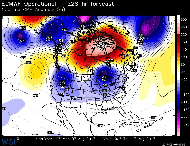
Now I don't know and maybe Scott or Rb can answer this but there looks to be a stout Omega block over Canada with a good ULL over the Midwest. The storm IF it does come north will have the Bermuda High to its east spinning and pressing (?) - will the trop cuclone feel the tug of this ULL? Will the BH press further west and force this - all questions that are a crap shoot and no frickin model can make this call. BUT one thing that is for sure is that we are having numerous bouts with -NAO's and this can be seen as in years past with low solar which is happening now and from predictions through till 2020
THIS IS WHAT I MEAN FOR NEXT WEEK:
EPS

WOOF WOOF
_________________
Mugs
AKA:King: Snow Weenie
Self Proclaimed
WINTER 2014-15 : 55.12" +.02 for 6 coatings (avg. 35")
WINTER 2015-16 Total - 29.8" (Avg 35")
WINTER 2016-17 : 39.5" so far

amugs- Advanced Forecaster - Mod

- Posts : 15095
Reputation : 213
Join date : 2013-01-07
Age : 54
Location : Hillsdale,NJ
Re: 2017 General Tropical Cyclone Discussion Thread
![]() by frank 638 Mon Aug 07, 2017 9:52 pm
by frank 638 Mon Aug 07, 2017 9:52 pm
frank 638- Senior Enthusiast
- Posts : 2843
Reputation : 37
Join date : 2016-01-01
Age : 40
Location : bronx ny
Re: 2017 General Tropical Cyclone Discussion Thread
![]() by jmanley32 Mon Aug 07, 2017 10:10 pm
by jmanley32 Mon Aug 07, 2017 10:10 pm

jmanley32- Senior Enthusiast
- Posts : 20535
Reputation : 108
Join date : 2013-12-12
Age : 43
Location : Yonkers, NY
Re: 2017 General Tropical Cyclone Discussion Thread
![]() by rb924119 Tue Aug 08, 2017 4:04 am
by rb924119 Tue Aug 08, 2017 4:04 am
jmanley32 wrote:if and at this point I'm go say it's a huge if we got a storm to intensify sub 960 even sub 950 headed up coast into or near the area that would be really rare. It appears by that pic that even the northeast Waters would keep it intense. What would be the factors there? I know the waters have not been quite as warm. Possibly too it could be a hybrid type situation. Of course this is all speculation to a undeveloped system. Franklin may be our first hurricane.rb924119 wrote:Well, that's the one thing I would be concerned with too, is a westward shift. I could see that happening more than an eastward trend, to be honest. And no worries, buddy haha we all know what you meant. Yes, it is from WxBell.
I don't have time to really answer in depth at the moment, unfortunately, but at the most basic level: 1. trough to the northwest of the system which dynamically puts it in an increasingly better place for large-scale ascent/development as the distance between them decreases 2. fresh injection of cooler, autumnal-like air over all of the eastern CONUS......with cooler air comes higher pressure that's forcing air out in all directions increasing relative convergence on the edges of the expanding airmass 3. a stalling frontal boundary at the eastern edge of that airmass with further enhanced convergence COLOCATED with a steep anomalous SST gradient along the coastal waters which will act to enhance the front and increase local convergence even more (cooler than normal water to the west building the local pressures even higher than those just with the cooler airmass, and warmer east decreasing the local pressure more ahead of the front). Basically, as the system continues westward it's going to feel the effects outlined above more and more, which is why we see it rapidly developing once near the Bahamas; it's close enough at that point where these factors start aiding its development. If I have time either tomorrow night or Thursday, if this system is still showing up (though I have little doubt about that), and if nobody else beats me to it (lol), I might be able to do a video better explaining my thoughts.
rb924119- Meteorologist

- Posts : 6928
Reputation : 194
Join date : 2013-02-06
Age : 32
Location : Greentown, Pa
Re: 2017 General Tropical Cyclone Discussion Thread
![]() by rb924119 Tue Aug 08, 2017 4:08 am
by rb924119 Tue Aug 08, 2017 4:08 am
rb924119- Meteorologist
- Posts : 6928
Reputation : 194
Join date : 2013-02-06
Age : 32
Location : Greentown, Pa
Re: 2017 General Tropical Cyclone Discussion Thread
![]() by jmanley32 Tue Aug 08, 2017 6:25 am
by jmanley32 Tue Aug 08, 2017 6:25 am
jmanley32- Senior Enthusiast
- Posts : 20535
Reputation : 108
Join date : 2013-12-12
Age : 43
Location : Yonkers, NY
Re: 2017 General Tropical Cyclone Discussion Thread
![]() by weatherwatchermom Tue Aug 08, 2017 7:35 am
by weatherwatchermom Tue Aug 08, 2017 7:35 am

weatherwatchermom- Senior Enthusiast
- Posts : 3793
Reputation : 78
Join date : 2014-11-25
Location : Hazlet Township, NJ
Re: 2017 General Tropical Cyclone Discussion Thread
![]() by skinsfan1177 Tue Aug 08, 2017 7:43 am
by skinsfan1177 Tue Aug 08, 2017 7:43 am

skinsfan1177- Senior Enthusiast
- Posts : 4485
Reputation : 35
Join date : 2013-01-07
Age : 46
Location : Point Pleasant Boro
Re: 2017 General Tropical Cyclone Discussion Thread
![]() by sroc4 Tue Aug 08, 2017 8:11 am
by sroc4 Tue Aug 08, 2017 8:11 am
amugs wrote:Frank no knows at this point so stay tuned. It could be this weekend as it passes into the Bahama region of the Caribbean or Early next week.frank 638 wrote:If this storm would would occur what day of next week will it happen i am leaving JFK to Aruba by next Thursday
There another wave on 99L tail and a couple more waves on the African continent looking to come off.
Now I don't know and maybe Scott or Rb can answer this but there looks to be a stout Omega block over Canada with a good ULL over the Midwest. The storm IF it does come north will have the Bermuda High to its east spinning and pressing (?) - will the trop cuclone feel the tug of this ULL? Will the BH press further west and force this - all questions that are a crap shoot and no frickin model can make this call. BUT one thing that is for sure is that we are having numerous bouts with -NAO's and this can be seen as in years past with low solar which is happening now and from predictions through till 2020
THIS IS WHAT I MEAN FOR NEXT WEEK:
EPS
WOOF WOOF
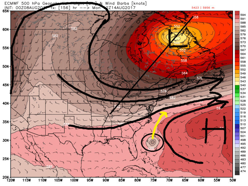
Mugs in the 500mb image you show above 99L has already been caught up in the westerly's of the trough and is somewhere in the Canadian maritime. Even still the eastern side of the ULL centered over the upper mid west/GL is very progressive. That is the problem. This system will def feel the effects of the trough causing it to eventually turn north but trough orientation will prevent it from affecting us I'm almost certain.
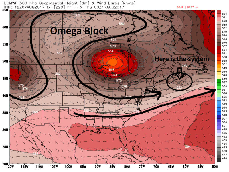
The problem is as you can see below when the system if off the SE coast notice the orientation of the trough. Positively tilted and extremely progressive. Its pretty clear where it will head from here. The question is still in the details of the timing of the trough because its the arrival of that trough that causes the weakness/erosion of the western flank of the Atlantic ridge. The progressive flow and the western edge of the Atlantic ridge will trigger the turn north, and steer this OTS. The question is how long will the ridge hold on, how strong is the system and where is it off the SE coast in the 3-5day time frame, and what is the timing of the trough such that can the system end up far enough west to make a landfall either before recurving or scrape the tip of Hatteras or the SE coastline as its recurving. As you can see by these two images below this is still 156-180hrs or 6-8days out so some of these details could change, but I believe that the large scale pattern at 500mb is such that I don't see any way for anyone N of Hatteras to be directly impacted by this system at this point.

_________________
"In weather and in life, there's no winning and losing; there's only winning and learning."
WINTER 2012/2013 TOTALS 43.65"WINTER 2017/2018 TOTALS 62.85" WINTER 2022/2023 TOTALS 4.9"
WINTER 2013/2014 TOTALS 64.85"WINTER 2018/2019 TOTALS 14.25" WINTER 2023/2024 TOTALS 13.1"
WINTER 2014/2015 TOTALS 71.20"WINTER 2019/2020 TOTALS 6.35"
WINTER 2015/2016 TOTALS 35.00"WINTER 2020/2021 TOTALS 37.75"
WINTER 2016/2017 TOTALS 42.25"WINTER 2021/2022 TOTALS 31.65"

sroc4- Admin

- Posts : 8354
Reputation : 302
Join date : 2013-01-07
Location : Wading River, LI
Re: 2017 General Tropical Cyclone Discussion Thread
![]() by jmanley32 Tue Aug 08, 2017 9:32 am
by jmanley32 Tue Aug 08, 2017 9:32 am
jmanley32- Senior Enthusiast
- Posts : 20535
Reputation : 108
Join date : 2013-12-12
Age : 43
Location : Yonkers, NY
Re: 2017 General Tropical Cyclone Discussion Thread
![]() by jmanley32 Tue Aug 08, 2017 9:34 am
by jmanley32 Tue Aug 08, 2017 9:34 am
jmanley32- Senior Enthusiast
- Posts : 20535
Reputation : 108
Join date : 2013-12-12
Age : 43
Location : Yonkers, NY
Re: 2017 General Tropical Cyclone Discussion Thread
![]() by rb924119 Tue Aug 08, 2017 12:21 pm
by rb924119 Tue Aug 08, 2017 12:21 pm
rb924119- Meteorologist
- Posts : 6928
Reputation : 194
Join date : 2013-02-06
Age : 32
Location : Greentown, Pa
Re: 2017 General Tropical Cyclone Discussion Thread
![]() by sroc4 Tue Aug 08, 2017 12:56 pm
by sroc4 Tue Aug 08, 2017 12:56 pm
rb924119 wrote:Unless there's a trough split, Scott
Exactly Ray!! We shall see.
_________________
"In weather and in life, there's no winning and losing; there's only winning and learning."
WINTER 2012/2013 TOTALS 43.65"WINTER 2017/2018 TOTALS 62.85" WINTER 2022/2023 TOTALS 4.9"
WINTER 2013/2014 TOTALS 64.85"WINTER 2018/2019 TOTALS 14.25" WINTER 2023/2024 TOTALS 13.1"
WINTER 2014/2015 TOTALS 71.20"WINTER 2019/2020 TOTALS 6.35"
WINTER 2015/2016 TOTALS 35.00"WINTER 2020/2021 TOTALS 37.75"
WINTER 2016/2017 TOTALS 42.25"WINTER 2021/2022 TOTALS 31.65"
sroc4- Admin
- Posts : 8354
Reputation : 302
Join date : 2013-01-07
Location : Wading River, LI
Re: 2017 General Tropical Cyclone Discussion Thread
![]() by sroc4 Tue Aug 08, 2017 2:31 pm
by sroc4 Tue Aug 08, 2017 2:31 pm
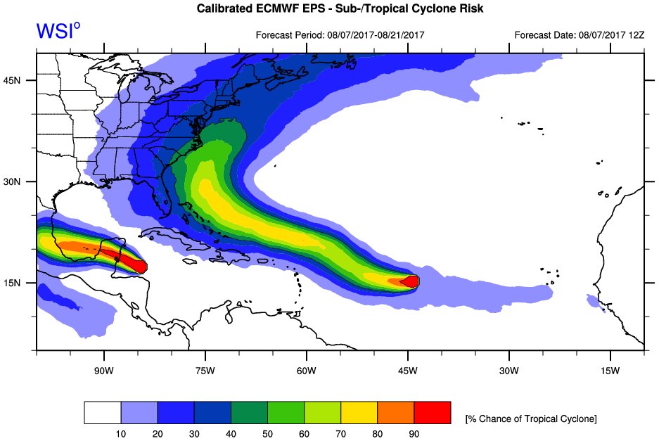
Almost undoubtedly if we end of with a tropical system somewhere off the SE coast; esp if its a hurricane, you will here people commenting on how the GFS was right the whole time.....NO!!!!! GFS doesn't seem to have the first clue whats goon in the tropics and continually plays catch up to the euro. I can see some ways the current GFS forecast of no development is correct; however, I will try and highlight all this tomorrow morning. I def think the euro has the right idea of developing 99L into our next named storm for many of the reasons touched on by rb some time in the next 3-5 days.
_________________
"In weather and in life, there's no winning and losing; there's only winning and learning."
WINTER 2012/2013 TOTALS 43.65"WINTER 2017/2018 TOTALS 62.85" WINTER 2022/2023 TOTALS 4.9"
WINTER 2013/2014 TOTALS 64.85"WINTER 2018/2019 TOTALS 14.25" WINTER 2023/2024 TOTALS 13.1"
WINTER 2014/2015 TOTALS 71.20"WINTER 2019/2020 TOTALS 6.35"
WINTER 2015/2016 TOTALS 35.00"WINTER 2020/2021 TOTALS 37.75"
WINTER 2016/2017 TOTALS 42.25"WINTER 2021/2022 TOTALS 31.65"
sroc4- Admin
- Posts : 8354
Reputation : 302
Join date : 2013-01-07
Location : Wading River, LI
Re: 2017 General Tropical Cyclone Discussion Thread
![]() by jmanley32 Tue Aug 08, 2017 3:15 pm
by jmanley32 Tue Aug 08, 2017 3:15 pm
is that something that might happen? Dunno if that's common or not. Scott gfs I don't think was right cuz we would have a decent sized hurricane now. I'm going with that it's playing catch up to eurosroc4 wrote:rb924119 wrote:Unless there's a trough split, Scott
Exactly Ray!! We shall see.
Cmc also identical to euro. How often can we say euro and cmc agree and gfs is out on its own.
jmanley32- Senior Enthusiast
- Posts : 20535
Reputation : 108
Join date : 2013-12-12
Age : 43
Location : Yonkers, NY
Re: 2017 General Tropical Cyclone Discussion Thread
![]() by amugs Tue Aug 08, 2017 3:29 pm
by amugs Tue Aug 08, 2017 3:29 pm

pretty strong HCane there as per Euro
_________________
Mugs
AKA:King: Snow Weenie
Self Proclaimed
WINTER 2014-15 : 55.12" +.02 for 6 coatings (avg. 35")
WINTER 2015-16 Total - 29.8" (Avg 35")
WINTER 2016-17 : 39.5" so far
amugs- Advanced Forecaster - Mod
- Posts : 15095
Reputation : 213
Join date : 2013-01-07
Age : 54
Location : Hillsdale,NJ
Re: 2017 General Tropical Cyclone Discussion Thread
![]() by amugs Tue Aug 08, 2017 3:33 pm
by amugs Tue Aug 08, 2017 3:33 pm
_________________
Mugs
AKA:King: Snow Weenie
Self Proclaimed
WINTER 2014-15 : 55.12" +.02 for 6 coatings (avg. 35")
WINTER 2015-16 Total - 29.8" (Avg 35")
WINTER 2016-17 : 39.5" so far
amugs- Advanced Forecaster - Mod
- Posts : 15095
Reputation : 213
Join date : 2013-01-07
Age : 54
Location : Hillsdale,NJ
Re: 2017 General Tropical Cyclone Discussion Thread
![]() by sroc4 Tue Aug 08, 2017 4:01 pm
by sroc4 Tue Aug 08, 2017 4:01 pm
jmanley32 wrote:is that something that might happen? Dunno if that's common or not. Scott gfs I don't think was right cuz we would have a decent sized hurricane now. I'm going with that it's playing catch up to eurosroc4 wrote:rb924119 wrote:Unless there's a trough split, Scott
Exactly Ray!! We shall see.
Cmc also identical to euro. How often can we say euro and cmc agree and gfs is out on its own.
It's def possible. It happens More than you think actually. In this scenario thus far modeling isn't showing this however. I personally don't think it will happen but since there is a plenty of time left for adjustments I'll wait another few days to call it a lock.
_________________
"In weather and in life, there's no winning and losing; there's only winning and learning."
WINTER 2012/2013 TOTALS 43.65"WINTER 2017/2018 TOTALS 62.85" WINTER 2022/2023 TOTALS 4.9"
WINTER 2013/2014 TOTALS 64.85"WINTER 2018/2019 TOTALS 14.25" WINTER 2023/2024 TOTALS 13.1"
WINTER 2014/2015 TOTALS 71.20"WINTER 2019/2020 TOTALS 6.35"
WINTER 2015/2016 TOTALS 35.00"WINTER 2020/2021 TOTALS 37.75"
WINTER 2016/2017 TOTALS 42.25"WINTER 2021/2022 TOTALS 31.65"
sroc4- Admin
- Posts : 8354
Reputation : 302
Join date : 2013-01-07
Location : Wading River, LI
Re: 2017 General Tropical Cyclone Discussion Thread
![]() by jmanley32 Tue Aug 08, 2017 4:37 pm
by jmanley32 Tue Aug 08, 2017 4:37 pm
yeah and u know the euro sometimes is on the weaker side of the actual putcome. Will have keep a eye on it. The way is limited still but it's not strung out as much.amugs wrote:
pretty strong HCane there as per Euro
jmanley32- Senior Enthusiast
- Posts : 20535
Reputation : 108
Join date : 2013-12-12
Age : 43
Location : Yonkers, NY
Re: 2017 General Tropical Cyclone Discussion Thread
![]() by Snow88 Tue Aug 08, 2017 6:00 pm
by Snow88 Tue Aug 08, 2017 6:00 pm

Snow88- Senior Enthusiast
- Posts : 2193
Reputation : 4
Join date : 2013-01-09
Age : 35
Location : Brooklyn, NY
Re: 2017 General Tropical Cyclone Discussion Thread
![]() by sroc4 Wed Aug 09, 2017 7:19 am
by sroc4 Wed Aug 09, 2017 7:19 am
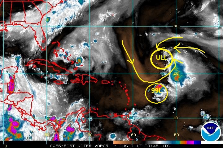
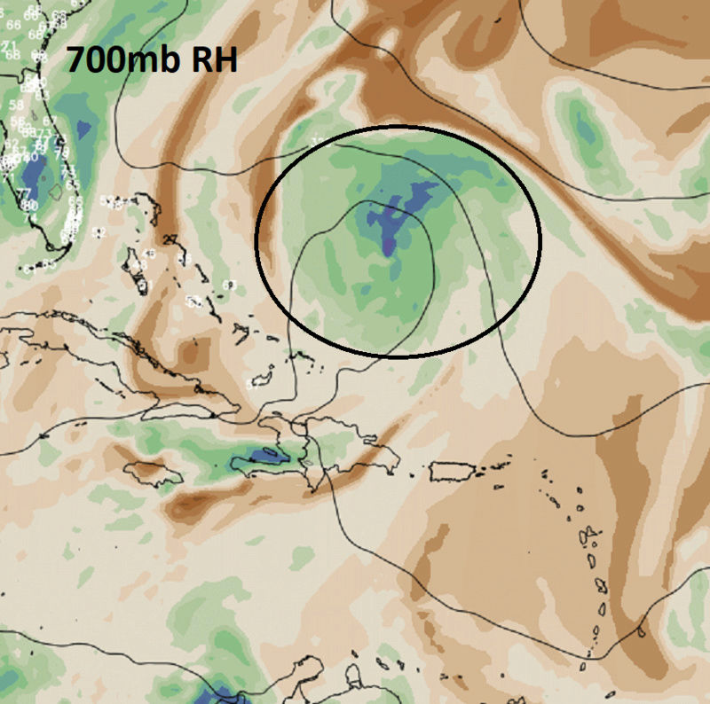
99L cont to be hindered by wind shear and dry air, but as it heads further and further W wind shear "should" subside some, and the dry air "should" become less and less of an issue.


Here is a nice discussion on 99L and Franklin posted by Levi Cowin last night: https://www.tropicaltidbits.com/
You can see on water vapor very clearly the upper level low (ULL) currently to the north of 99L.

By about 12Z Saturday is where the models diverge on what happens to this ULL as Levi describes in his write up. Both GFS and Euro have the center of 99L in about the same spot.
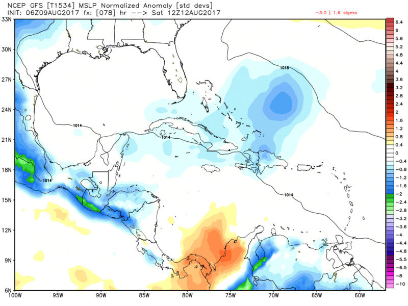

As you can see in the images of the 200mb wind field below (GFS first; then Euro) The GFS wants to keep this ULL intact whereas the Euro degrades it and actually develops anti-cyclonic flow aloft. When looking at these 200mb level maps pay attention to the direction of the arrows within the area I have circled. The GFS has them traveling towards the center(counter clockwise cyclonic flow = ULL). This creates "convergence" aloft. When this occurs the air crashes into itself at the center of the ULL and some is deflected downward which means sinking air over top 99L which means unfavorable conditions for further development.
Euro; however, notice the arrows are traveling away from the center creating "divergence" aloft. Air moving away from a center point in the upper levels means the air beneath it races vertically in the atmosphere to replace said divergent air which ultimately enhances lower pressures at the surface and a more favorable environment for development of 99L.

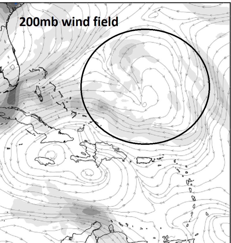
Below there are also other differences between models. GFS has a tongue of dry air also infiltrating the system whereas, the Euro seems to mixed out the dry air

Once again which model is less wrong/more right. As Rb has eluded to in prev posts there are some dynamics at play regarding the trough that will be approaching the east coast that should aid in creating an environment that should enhance development as 99L head on its W to NW track. Specifically a favorably positioned upper level jetstreak over southern NE and a fairly potent baroclinic zone associated with the frontal structure. Time will tell.
_________________
"In weather and in life, there's no winning and losing; there's only winning and learning."
WINTER 2012/2013 TOTALS 43.65"WINTER 2017/2018 TOTALS 62.85" WINTER 2022/2023 TOTALS 4.9"
WINTER 2013/2014 TOTALS 64.85"WINTER 2018/2019 TOTALS 14.25" WINTER 2023/2024 TOTALS 13.1"
WINTER 2014/2015 TOTALS 71.20"WINTER 2019/2020 TOTALS 6.35"
WINTER 2015/2016 TOTALS 35.00"WINTER 2020/2021 TOTALS 37.75"
WINTER 2016/2017 TOTALS 42.25"WINTER 2021/2022 TOTALS 31.65"
sroc4- Admin
- Posts : 8354
Reputation : 302
Join date : 2013-01-07
Location : Wading River, LI
Re: 2017 General Tropical Cyclone Discussion Thread
![]() by sroc4 Wed Aug 09, 2017 11:32 am
by sroc4 Wed Aug 09, 2017 11:32 am


_________________
"In weather and in life, there's no winning and losing; there's only winning and learning."
WINTER 2012/2013 TOTALS 43.65"WINTER 2017/2018 TOTALS 62.85" WINTER 2022/2023 TOTALS 4.9"
WINTER 2013/2014 TOTALS 64.85"WINTER 2018/2019 TOTALS 14.25" WINTER 2023/2024 TOTALS 13.1"
WINTER 2014/2015 TOTALS 71.20"WINTER 2019/2020 TOTALS 6.35"
WINTER 2015/2016 TOTALS 35.00"WINTER 2020/2021 TOTALS 37.75"
WINTER 2016/2017 TOTALS 42.25"WINTER 2021/2022 TOTALS 31.65"
sroc4- Admin
- Posts : 8354
Reputation : 302
Join date : 2013-01-07
Location : Wading River, LI
Re: 2017 General Tropical Cyclone Discussion Thread
![]() by sroc4 Wed Aug 09, 2017 1:08 pm
by sroc4 Wed Aug 09, 2017 1:08 pm

_________________
"In weather and in life, there's no winning and losing; there's only winning and learning."
WINTER 2012/2013 TOTALS 43.65"WINTER 2017/2018 TOTALS 62.85" WINTER 2022/2023 TOTALS 4.9"
WINTER 2013/2014 TOTALS 64.85"WINTER 2018/2019 TOTALS 14.25" WINTER 2023/2024 TOTALS 13.1"
WINTER 2014/2015 TOTALS 71.20"WINTER 2019/2020 TOTALS 6.35"
WINTER 2015/2016 TOTALS 35.00"WINTER 2020/2021 TOTALS 37.75"
WINTER 2016/2017 TOTALS 42.25"WINTER 2021/2022 TOTALS 31.65"
sroc4- Admin
- Posts : 8354
Reputation : 302
Join date : 2013-01-07
Location : Wading River, LI
Re: 2017 General Tropical Cyclone Discussion Thread
![]() by sroc4 Wed Aug 09, 2017 1:11 pm
by sroc4 Wed Aug 09, 2017 1:11 pm

_________________
"In weather and in life, there's no winning and losing; there's only winning and learning."
WINTER 2012/2013 TOTALS 43.65"WINTER 2017/2018 TOTALS 62.85" WINTER 2022/2023 TOTALS 4.9"
WINTER 2013/2014 TOTALS 64.85"WINTER 2018/2019 TOTALS 14.25" WINTER 2023/2024 TOTALS 13.1"
WINTER 2014/2015 TOTALS 71.20"WINTER 2019/2020 TOTALS 6.35"
WINTER 2015/2016 TOTALS 35.00"WINTER 2020/2021 TOTALS 37.75"
WINTER 2016/2017 TOTALS 42.25"WINTER 2021/2022 TOTALS 31.65"
sroc4- Admin
- Posts : 8354
Reputation : 302
Join date : 2013-01-07
Location : Wading River, LI
Re: 2017 General Tropical Cyclone Discussion Thread
![]() by jmanley32 Wed Aug 09, 2017 3:15 pm
by jmanley32 Wed Aug 09, 2017 3:15 pm
jmanley32- Senior Enthusiast
- Posts : 20535
Reputation : 108
Join date : 2013-12-12
Age : 43
Location : Yonkers, NY
Page 6 of 40 • 1 ... 5, 6, 7 ... 23 ... 40 ![]()
|
|
|