
 Search
2017 General Tropical Cyclone Discussion Thread
Page 16 of 40 •  1 ... 9 ... 15, 16, 17 ... 28 ... 40
 ![]()
Re: 2017 General Tropical Cyclone Discussion Thread
![]() by jmanley32 Fri Aug 25, 2017 1:58 am
by jmanley32 Fri Aug 25, 2017 1:58 am
jmanley32- Senior Enthusiast

- Posts : 20516
Join date : 2013-12-12
Re: 2017 General Tropical Cyclone Discussion Thread
![]() by jmanley32 Fri Aug 25, 2017 2:41 am
by jmanley32 Fri Aug 25, 2017 2:41 am
jmanley32- Senior Enthusiast
- Posts : 20516
Join date : 2013-12-12
Re: 2017 General Tropical Cyclone Discussion Thread
![]() by skinsfan1177 Fri Aug 25, 2017 6:14 am
by skinsfan1177 Fri Aug 25, 2017 6:14 am

skinsfan1177- Senior Enthusiast
- Posts : 4485
Reputation : 35
Join date : 2013-01-07
Age : 46
Location : Point Pleasant Boro
Re: 2017 General Tropical Cyclone Discussion Thread
![]() by jmanley32 Fri Aug 25, 2017 8:31 am
by jmanley32 Fri Aug 25, 2017 8:31 am

jmanley32- Senior Enthusiast
- Posts : 20516
Reputation : 108
Join date : 2013-12-12
Age : 42
Location : Yonkers, NY
Re: 2017 General Tropical Cyclone Discussion Thread
![]() by gigs68 Fri Aug 25, 2017 8:45 am
by gigs68 Fri Aug 25, 2017 8:45 am
Snow88 wrote:Anyone have good cams from south Texas?
Here's a few I found
http://www.beachcamsusa.com/tx/corpus-christi/corpus-christi-bayfront-and-marina-webcam
http://www.citynet.cc/customer-service-center/bayfront-webcam/index
http://www.bolivarpeninsulatexas.com/Webcams/Bluewater-Beach
http://www.bolivarpeninsulatexas.com/Webcams/Sunrise-Beach

gigs68- Posts : 142
Reputation : 3
Join date : 2013-01-16
Location : Commack, NY (NW Suffolk)
Re: 2017 General Tropical Cyclone Discussion Thread
![]() by amugs Fri Aug 25, 2017 9:11 am
by amugs Fri Aug 25, 2017 9:11 am
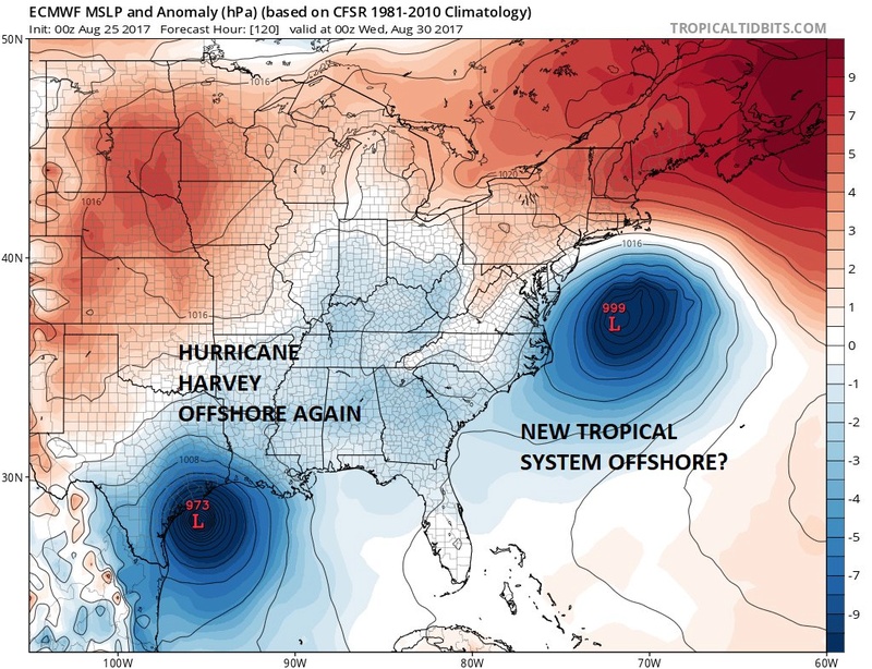
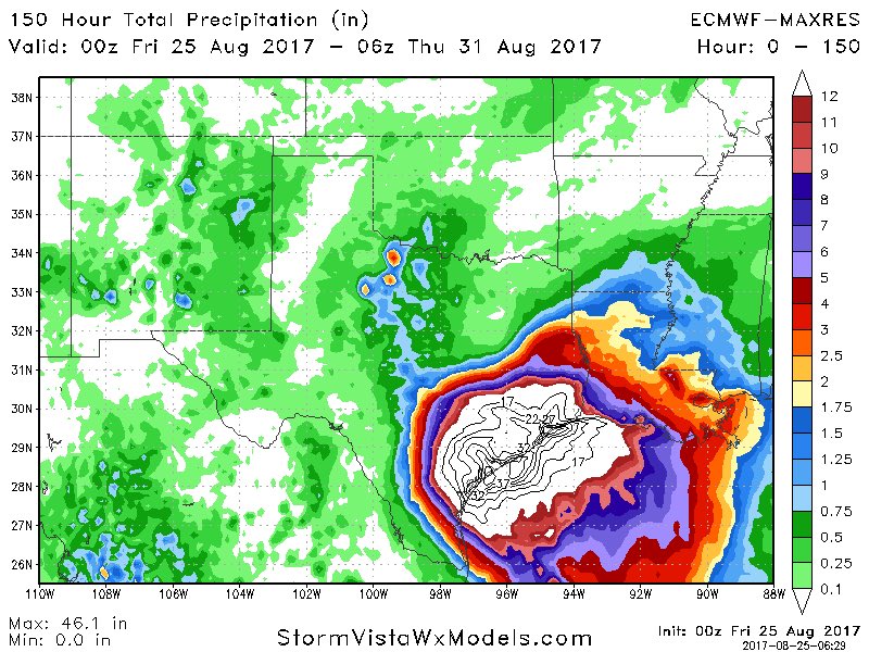
Harvard the Texas coast wall banger is going to intensify the a CAT 4. I called a 125 plus CAT 3 on my site but underestimated him a bit. Isotherm called a CAT 4 on another site. He is Frickin genius.
Rb your fears or excitement on Irma are coming my man.
That trough in central CAN looks to be swinging into the Lower GL Tuesday ish which could spell a NNW track for Harveys GF!
Two Hcanes effectin the US coasts at the same time?? Not a first nor a last. And IF anyone says GW or CO2 is causing this then you need to learn your histroy.
Harvey is going to wash away those barrier islands in Texas, double landfall call by JB is real. IF he makes landfall 2x as a Major how does that count?? Two major hcane hits in 3 days?
Euro last night jumping on board
_________________
Mugs
AKA:King: Snow Weenie
Self Proclaimed
WINTER 2014-15 : 55.12" +.02 for 6 coatings (avg. 35")
WINTER 2015-16 Total - 29.8" (Avg 35")
WINTER 2016-17 : 39.5" so far

amugs- Advanced Forecaster - Mod

- Posts : 15093
Reputation : 213
Join date : 2013-01-07
Age : 54
Location : Hillsdale,NJ
Re: 2017 General Tropical Cyclone Discussion Thread
![]() by amugs Fri Aug 25, 2017 9:15 am
by amugs Fri Aug 25, 2017 9:15 am
Yupjmanley32 wrote:Yeah I think 115mph is go be exceeded easily high cat 3 maybe 4 looks like now. Scary for Texas. That rain is just OMG.
I SAW NOAH BUILDING AN ARK IF THAT IS AN ANY INDICATION
_________________
Mugs
AKA:King: Snow Weenie
Self Proclaimed
WINTER 2014-15 : 55.12" +.02 for 6 coatings (avg. 35")
WINTER 2015-16 Total - 29.8" (Avg 35")
WINTER 2016-17 : 39.5" so far
amugs- Advanced Forecaster - Mod
- Posts : 15093
Reputation : 213
Join date : 2013-01-07
Age : 54
Location : Hillsdale,NJ
Re: 2017 General Tropical Cyclone Discussion Thread
![]() by Snow88 Fri Aug 25, 2017 9:22 am
by Snow88 Fri Aug 25, 2017 9:22 am

Snow88- Senior Enthusiast
- Posts : 2193
Reputation : 4
Join date : 2013-01-09
Age : 35
Location : Brooklyn, NY
Re: 2017 General Tropical Cyclone Discussion Thread
![]() by weatherwatchermom Fri Aug 25, 2017 9:28 am
by weatherwatchermom Fri Aug 25, 2017 9:28 am
Mugs what is going on with 92L?

weatherwatchermom- Senior Enthusiast
- Posts : 3747
Reputation : 77
Join date : 2014-11-25
Age : 60
Location : Hazlet Township, NJ
Re: 2017 General Tropical Cyclone Discussion Thread
![]() by skinsfan1177 Fri Aug 25, 2017 9:28 am
by skinsfan1177 Fri Aug 25, 2017 9:28 am
Snow88 wrote:CMC of 92L is possible if the trough catches up to the storm and yanks it back. Long shot but possible.
Not sure that its a long shot
skinsfan1177- Senior Enthusiast
- Posts : 4485
Reputation : 35
Join date : 2013-01-07
Age : 46
Location : Point Pleasant Boro
Re: 2017 General Tropical Cyclone Discussion Thread
![]() by Snow88 Fri Aug 25, 2017 9:36 am
by Snow88 Fri Aug 25, 2017 9:36 am
skinsfan1177 wrote:Snow88 wrote:CMC of 92L is possible if the trough catches up to the storm and yanks it back. Long shot but possible.
Not sure that its a long shot
Any tropical system that reaches this far north is a long shot
Snow88- Senior Enthusiast
- Posts : 2193
Reputation : 4
Join date : 2013-01-09
Age : 35
Location : Brooklyn, NY
Re: 2017 General Tropical Cyclone Discussion Thread
![]() by skinsfan1177 Fri Aug 25, 2017 9:52 am
by skinsfan1177 Fri Aug 25, 2017 9:52 am
skinsfan1177- Senior Enthusiast
- Posts : 4485
Reputation : 35
Join date : 2013-01-07
Age : 46
Location : Point Pleasant Boro
Re: 2017 General Tropical Cyclone Discussion Thread
![]() by sroc4 Fri Aug 25, 2017 10:03 am
by sroc4 Fri Aug 25, 2017 10:03 am
Snow88 wrote:skinsfan1177 wrote:Snow88 wrote:CMC of 92L is possible if the trough catches up to the storm and yanks it back. Long shot but possible.
Not sure that its a long shot
Any tropical system that reaches this far north is a long shot
Making that statement a month ago sure,but given the set up it def. isn't a long shot as of this am. As models cont to trend slower with lifting 92 the better the chances.
Last edited by sroc4 on Fri Aug 25, 2017 10:29 am; edited 1 time in total
_________________
"In weather and in life, there's no winning and losing; there's only winning and learning."
WINTER 2012/2013 TOTALS 43.65"WINTER 2017/2018 TOTALS 62.85" WINTER 2022/2023 TOTALS 4.9"
WINTER 2013/2014 TOTALS 64.85"WINTER 2018/2019 TOTALS 14.25" WINTER 2023/2024 TOTALS 13.1"
WINTER 2014/2015 TOTALS 71.20"WINTER 2019/2020 TOTALS 6.35"
WINTER 2015/2016 TOTALS 35.00"WINTER 2020/2021 TOTALS 37.75"
WINTER 2016/2017 TOTALS 42.25"WINTER 2021/2022 TOTALS 31.65"

sroc4- Admin

- Posts : 8331
Reputation : 301
Join date : 2013-01-07
Location : Wading River, LI
Re: 2017 General Tropical Cyclone Discussion Thread
![]() by jmanley32 Fri Aug 25, 2017 10:10 am
by jmanley32 Fri Aug 25, 2017 10:10 am
jmanley32- Senior Enthusiast
- Posts : 20516
Reputation : 108
Join date : 2013-12-12
Age : 42
Location : Yonkers, NY
Re: 2017 General Tropical Cyclone Discussion Thread
![]() by sroc4 Fri Aug 25, 2017 10:46 am
by sroc4 Fri Aug 25, 2017 10:46 am
The big question marks are:
1) What and where are Harvey in the next 2-3 days
2) Intensity of Irma. Models have done an aweful job forecasting intensity.
3) positioning and interactions of Midwest trough with Harvey
4) positioning and strength of Irma with respect to currently exiting trough in the NE. Models cont to move it out faster and keep Irma further south leading to more ridge in the NE. As I out lined several days ago this last question will be vital to the steering of Irma. Does she get cutoff from the flow that would take her OTS and get picked up by the trough in the Midwest? Mid west trough orientation is just as important. Positive tilt means OTS. Neutral or neg tilt means more Ridge and a steering flow more North or northwest.
Again I don't think it's a long shot to say Irma may still affect the mid Atlantic and orb NE states but currently favor against it. We shall see.
_________________
"In weather and in life, there's no winning and losing; there's only winning and learning."
WINTER 2012/2013 TOTALS 43.65"WINTER 2017/2018 TOTALS 62.85" WINTER 2022/2023 TOTALS 4.9"
WINTER 2013/2014 TOTALS 64.85"WINTER 2018/2019 TOTALS 14.25" WINTER 2023/2024 TOTALS 13.1"
WINTER 2014/2015 TOTALS 71.20"WINTER 2019/2020 TOTALS 6.35"
WINTER 2015/2016 TOTALS 35.00"WINTER 2020/2021 TOTALS 37.75"
WINTER 2016/2017 TOTALS 42.25"WINTER 2021/2022 TOTALS 31.65"
sroc4- Admin
- Posts : 8331
Reputation : 301
Join date : 2013-01-07
Location : Wading River, LI
Re: 2017 General Tropical Cyclone Discussion Thread
![]() by RJB8525 Fri Aug 25, 2017 10:48 am
by RJB8525 Fri Aug 25, 2017 10:48 am

you'd expect to see this in winter the amounts..33",12 etc...this is unbelievable

RJB8525- Senior Enthusiast
- Posts : 1994
Reputation : 28
Join date : 2013-02-06
Age : 38
Location : Hackettstown, NJ
Re: 2017 General Tropical Cyclone Discussion Thread
![]() by aiannone Fri Aug 25, 2017 10:56 am
by aiannone Fri Aug 25, 2017 10:56 am
_________________
-Alex Iannone-

aiannone- Senior Enthusiast - Mod
- Posts : 4814
Reputation : 92
Join date : 2013-01-07
Location : Saint James, LI (Northwest Suffolk Co.)
Re: 2017 General Tropical Cyclone Discussion Thread
![]() by Radz Fri Aug 25, 2017 11:43 am
by Radz Fri Aug 25, 2017 11:43 am
946 and still dropping, Cat 3 once winds respond...jmanley32 wrote:Yeah I think 115mph is go be exceeded easily high cat 3 maybe 4 looks like now. Scary for Texas. That rain is just OMG.

Radz- Pro Enthusiast

- Posts : 1028
Reputation : 17
Join date : 2013-01-12
Location : Cortlandt Manor NY
Re: 2017 General Tropical Cyclone Discussion Thread
![]() by Joe Snow Fri Aug 25, 2017 12:00 pm
by Joe Snow Fri Aug 25, 2017 12:00 pm
http://www.beachcamsusa.com/tx/south-padre-island/live-south-padre-island-hd-cam-north-beach

Joe Snow- Pro Enthusiast
- Posts : 924
Reputation : 7
Join date : 2014-02-12
Age : 62
Location : Sanford Florida, Fmrly Kings Park, NY
Re: 2017 General Tropical Cyclone Discussion Thread
![]() by amugs Fri Aug 25, 2017 12:17 pm
by amugs Fri Aug 25, 2017 12:17 pm
_________________
Mugs
AKA:King: Snow Weenie
Self Proclaimed
WINTER 2014-15 : 55.12" +.02 for 6 coatings (avg. 35")
WINTER 2015-16 Total - 29.8" (Avg 35")
WINTER 2016-17 : 39.5" so far
amugs- Advanced Forecaster - Mod
- Posts : 15093
Reputation : 213
Join date : 2013-01-07
Age : 54
Location : Hillsdale,NJ
Re: 2017 General Tropical Cyclone Discussion Thread
![]() by jmanley32 Fri Aug 25, 2017 12:18 pm
by jmanley32 Fri Aug 25, 2017 12:18 pm
jmanley32- Senior Enthusiast
- Posts : 20516
Reputation : 108
Join date : 2013-12-12
Age : 42
Location : Yonkers, NY
Re: 2017 General Tropical Cyclone Discussion Thread
![]() by amugs Fri Aug 25, 2017 12:22 pm
by amugs Fri Aug 25, 2017 12:22 pm
Don't take these model verbatim, next 48 hours it should.pop as a trop cyclone so it may not be too far off. Later the better.
_________________
Mugs
AKA:King: Snow Weenie
Self Proclaimed
WINTER 2014-15 : 55.12" +.02 for 6 coatings (avg. 35")
WINTER 2015-16 Total - 29.8" (Avg 35")
WINTER 2016-17 : 39.5" so far
amugs- Advanced Forecaster - Mod
- Posts : 15093
Reputation : 213
Join date : 2013-01-07
Age : 54
Location : Hillsdale,NJ
Re: 2017 General Tropical Cyclone Discussion Thread
![]() by weatherwatchermom Fri Aug 25, 2017 12:38 pm
by weatherwatchermom Fri Aug 25, 2017 12:38 pm
sroc4 wrote:I'm in Denver right now jman with some friends so I won't be able to put together anything detailed with maps. I would say I am 40% makes it up past OBx and affects the mid Atlantic coast/S NE and 60% OTS. When I say OTS I mean as far as mid Atlantic and NE. It still can and likely will after the coast on some level from outer banks on south.
The big question marks are:
1) What and where are Harvey in the next 2-3 days
2) Intensity of Irma. Models have done an aweful job forecasting intensity.
3) positioning and interactions of Midwest trough with Harvey
4) positioning and strength of Irma with respect to currently exiting trough in the NE. Models cont to move it out faster and keep Irma further south leading to more ridge in the NE. As I out lined several days ago this last question will be vital to the steering of Irma. Does she get cutoff from the flow that would take her OTS and get picked up by the trough in the Midwest? Mid west trough orientation is just as important. Positive tilt means OTS. Neutral or neg tilt means more Ridge and a steering flow more North or northwest.
Again I don't think it's a long shot to say Irma may still affect the mid Atlantic and orb NE states but currently favor against it. We shall see.
thank you for giving us an update..happy birthday to you and your friends....and happy vacation!!
weatherwatchermom- Senior Enthusiast
- Posts : 3747
Reputation : 77
Join date : 2014-11-25
Age : 60
Location : Hazlet Township, NJ
Re: 2017 General Tropical Cyclone Discussion Thread
![]() by jmanley32 Fri Aug 25, 2017 12:51 pm
by jmanley32 Fri Aug 25, 2017 12:51 pm
Mugs that would be quick so I'd expect nhc to bump the chances up pretty quick between now and sun. As sroc said we will see.
As for Texas all I can say is dayumm and pray for all. Seeing cat 4 possibility there.
East coast could surprise too maybe cat 1 or 2. Cat 1 would be bad up here cat 2 would b really bad here our trees were trashed by Sandy winds over 100 I couldn't even imsgine. Not gonna speculate anything though. Who knows with these models maybe goes cat 7. Lol I know there is no cat 7 a joke. And a horrible made for tv movie.
jmanley32- Senior Enthusiast
- Posts : 20516
Reputation : 108
Join date : 2013-12-12
Age : 42
Location : Yonkers, NY
Re: 2017 General Tropical Cyclone Discussion Thread
![]() by RJB8525 Fri Aug 25, 2017 1:31 pm
by RJB8525 Fri Aug 25, 2017 1:31 pm
RJB8525- Senior Enthusiast
- Posts : 1994
Reputation : 28
Join date : 2013-02-06
Age : 38
Location : Hackettstown, NJ
Re: 2017 General Tropical Cyclone Discussion Thread
![]() by gigs68 Fri Aug 25, 2017 2:48 pm
by gigs68 Fri Aug 25, 2017 2:48 pm
gigs68- Posts : 142
Reputation : 3
Join date : 2013-01-16
Location : Commack, NY (NW Suffolk)
Re: 2017 General Tropical Cyclone Discussion Thread
![]() by weatherwatchermom Fri Aug 25, 2017 3:03 pm
by weatherwatchermom Fri Aug 25, 2017 3:03 pm
weatherwatchermom- Senior Enthusiast
- Posts : 3747
Reputation : 77
Join date : 2014-11-25
Age : 60
Location : Hazlet Township, NJ
Page 16 of 40 • 1 ... 9 ... 15, 16, 17 ... 28 ... 40 ![]()
|
|
|