
 Search
2017 General Tropical Cyclone Discussion Thread
Page 9 of 40 •  1 ... 6 ... 8, 9, 10 ... 24 ... 40
 ![]()
Re: 2017 General Tropical Cyclone Discussion Thread
![]() by Dunnzoo Mon Aug 14, 2017 10:24 pm
by Dunnzoo Mon Aug 14, 2017 10:24 pm
rb924119 wrote:I'm putting this out there now; I only glanced at things on my phone so take this as you will, but man oh man I am absolutely concerned for the East Coast in the 8-11/7-10 day period, especially with the look of the EURO Ensemble 500hPa maps.
Can you post a map when you get a chance, or link? I am going to be down the shore from 8/19-9/2. Any of our shore peeps, how about a gtg? I'll be in Seaside Park
Dunnzoo- Senior Enthusiast - Mod

- Posts : 4891
Join date : 2013-01-11
Re: 2017 General Tropical Cyclone Discussion Thread
![]() by jmanley32 Mon Aug 14, 2017 10:25 pm
by jmanley32 Mon Aug 14, 2017 10:25 pm
Hoilding you to it for some excitement, hey you were spot on with your predictions of Gert. I heard Gert has slowed even more, Theres no way that if she slows so much could miss the front? Can you elaborate about the 10 day and which system your concerned (assuming 91L?) though all sgetti plots right now show a gulf run, but of course we dont know where formation will take place so that could change drastically. Interestingly enough, its not the ellusive "I" storm yet but this is close in date to when Irene struck (end of August). Entire EC? Interested to hear your thoughts, maybe a video in a few days if 500mb still looks like you say?rb924119 wrote:I'm putting this out there now; I only glanced at things on my phone so take this as you will, but man oh man I am absolutely concerned for the East Coast in the 8-11/7-10 day period, especially with the look of the EURO Ensemble 500hPa maps.
jmanley32- Senior Enthusiast

- Posts : 20516
Join date : 2013-12-12
Re: 2017 General Tropical Cyclone Discussion Thread
![]() by jmanley32 Mon Aug 14, 2017 10:53 pm
by jmanley32 Mon Aug 14, 2017 10:53 pm

jmanley32- Senior Enthusiast
- Posts : 20516
Reputation : 108
Join date : 2013-12-12
Age : 42
Location : Yonkers, NY
Re: 2017 General Tropical Cyclone Discussion Thread
![]() by amugs Mon Aug 14, 2017 11:05 pm
by amugs Mon Aug 14, 2017 11:05 pm
_________________
Mugs
AKA:King: Snow Weenie
Self Proclaimed
WINTER 2014-15 : 55.12" +.02 for 6 coatings (avg. 35")
WINTER 2015-16 Total - 29.8" (Avg 35")
WINTER 2016-17 : 39.5" so far

amugs- Advanced Forecaster - Mod
- Posts : 15093
Reputation : 213
Join date : 2013-01-07
Age : 54
Location : Hillsdale,NJ
Re: 2017 General Tropical Cyclone Discussion Thread
![]() by jmanley32 Mon Aug 14, 2017 11:25 pm
by jmanley32 Mon Aug 14, 2017 11:25 pm
But will there be steering to recurve like with Gert? many get that far west but turn OTS.amugs wrote:There are big high positives over SE CAN and a trough over the upper midwest with a big positive over the NW. As JB says look out below when u you have a big positive over SE CAN. Steering flow from the big BH is going to have these round it's base from my opinion and shoot these into the western Atlantic around mid to Bahamas region from the looks.
jmanley32- Senior Enthusiast
- Posts : 20516
Reputation : 108
Join date : 2013-12-12
Age : 42
Location : Yonkers, NY
Re: 2017 General Tropical Cyclone Discussion Thread
![]() by sroc4 Tue Aug 15, 2017 8:12 am
by sroc4 Tue Aug 15, 2017 8:12 am
Things to remember. The stronger a system is the more likely, but not a foregone conclusion, a system is to recurve through any weaknesses in the Atlantic ridge anywhere along its path. The weaker the system the easier it is for the Atlantic ridging complex to continue to steer it along its southern periphery closer to the US. The timing, strength, and positioning of the trough along with the trough axis orientation(positive, neutral, or negative tilt) can aid in pulling a tropical system into the coast(ala Sandy as an example with a neg tilted trough), or steer it harmlessly OTS(ala Gert right now with positive tilted trough). So with a long way to go the area from the GOM all the way up the EC and OTS is still in play for the time frame Rb has outlined, but the pattern suggests we need to monitor things closely along the EC.
_________________
"In weather and in life, there's no winning and losing; there's only winning and learning."
WINTER 2012/2013 TOTALS 43.65"WINTER 2017/2018 TOTALS 62.85" WINTER 2022/2023 TOTALS 4.9"
WINTER 2013/2014 TOTALS 64.85"WINTER 2018/2019 TOTALS 14.25" WINTER 2023/2024 TOTALS 13.1"
WINTER 2014/2015 TOTALS 71.20"WINTER 2019/2020 TOTALS 6.35"
WINTER 2015/2016 TOTALS 35.00"WINTER 2020/2021 TOTALS 37.75"
WINTER 2016/2017 TOTALS 42.25"WINTER 2021/2022 TOTALS 31.65"

sroc4- Admin

- Posts : 8331
Reputation : 301
Join date : 2013-01-07
Location : Wading River, LI
Re: 2017 General Tropical Cyclone Discussion Thread
![]() by jmanley32 Tue Aug 15, 2017 8:30 am
by jmanley32 Tue Aug 15, 2017 8:30 am
jmanley32- Senior Enthusiast
- Posts : 20516
Reputation : 108
Join date : 2013-12-12
Age : 42
Location : Yonkers, NY
Re: 2017 General Tropical Cyclone Discussion Thread
![]() by jmanley32 Tue Aug 15, 2017 8:38 am
by jmanley32 Tue Aug 15, 2017 8:38 am
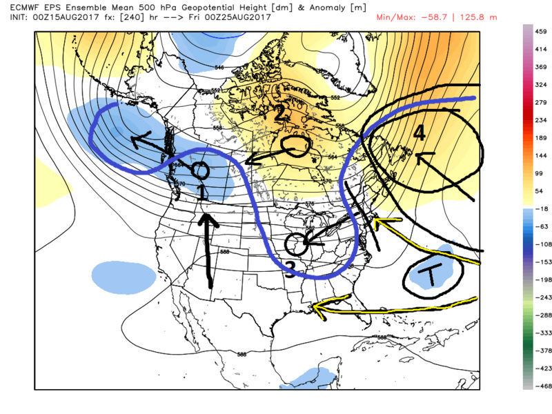
thanks for the analysis it makes sense. Euro has the system pretty far out in open waters usually getting something like that to land would b challenging. Any credit to the gfs solution of a coastal rider up ec? I know it's early to tell but which if u had to guess would handle the upper level the way u think?sroc4 wrote:Hopefully rb can do a more detailed analysis than this with a video, but it boils down to pattern recognition. Here is the Euro ens mean 500mb anomaly map day ten. The message would be much easier to convey in a video but hopefully it will make some sense by what I have drawn on the map. Starting with 1 on the map. The strung out blue colors from the GOA into W Canada means that this far out there is still a wide range of solns amongst the 50 members as to where the center of a trough in this area will be. We all know as we get in closer in time these will converge and show a more defined trough. If you pull back the blues where I have labeled 1 into the GOA, or if you split the difference and say center the trough somewhere in the middle, the result means that the area currently labeled 1 with blue colors would be replaced by positive heights, or orange and yellows. Those positive heights I labeled 2, would likely be centered further west as a result of the blues labeled 1 being centered further west. Its a chain reaction. If 2 is further west than the trough axis I have labeled along the EC (solid black line cutting through New England) is likely centered further west in the mid west somewhere as seen by the label 3. If the trough axis is further west then there will likely be more ridge(positive heights labled 4) over top the area I labeled T. (T) This is the trop system the euro ens sees this far out. If the ensemble members converge on a soln similar to what is stated you will get a 500mb steering flow roughly like the blue one I have drawn in. More ridge over top in SE Canada and the N atlantic (Bermuda high), means a track for that system labeled T further west under the Atlantic/SE Canadian ridging, aka blocking. (see yellow/black arrows). A lot can happen between now and then. There are multiple waves that may or may not develop.
Things to remember. The stronger a system is the more likely, but not a foregone conclusion, a system is to recurve through any weaknesses in the Atlantic ridge anywhere along its path. The weaker the system the easier it is for the Atlantic ridging complex to continue to steer it along its southern periphery closer to the US. The timing, strength, and positioning of the trough along with the trough axis orientation(positive, neutral, or negative tilt) can aid in pulling a tropical system into the coast(ala Sandy as an example with a neg tilted trough), or steer it harmlessly OTS(ala Gert right now with positive tilted trough). So with a long way to go the area from the GOM all the way up the EC and OTS is still in play for the time frame Rb has outlined, but the pattern suggests we need to monitor things closely along the EC.
jmanley32- Senior Enthusiast
- Posts : 20516
Reputation : 108
Join date : 2013-12-12
Age : 42
Location : Yonkers, NY
Re: 2017 General Tropical Cyclone Discussion Thread
![]() by sroc4 Tue Aug 15, 2017 9:30 am
by sroc4 Tue Aug 15, 2017 9:30 am
jmanley32 wrote:thanks for the analysis it makes sense. Euro has the system pretty far out in open waters usually getting something like that to land would b challenging. Any credit to the gfs solution of a coastal rider up ec? I know it's early to tell but which if u had to guess would handle the upper level the way u think?sroc4 wrote:Hopefully rb can do a more detailed analysis than this with a video, but it boils down to pattern recognition. Here is the Euro ens mean 500mb anomaly map day ten. The message would be much easier to convey in a video but hopefully it will make some sense by what I have drawn on the map. Starting with 1 on the map. The strung out blue colors from the GOA into W Canada means that this far out there is still a wide range of solns amongst the 50 members as to where the center of a trough in this area will be. We all know as we get in closer in time these will converge and show a more defined trough. If you pull back the blues where I have labeled 1 into the GOA, or if you split the difference and say center the trough somewhere in the middle, the result means that the area currently labeled 1 with blue colors would be replaced by positive heights, or orange and yellows. Those positive heights I labeled 2, would likely be centered further west as a result of the blues labeled 1 being centered further west. Its a chain reaction. If 2 is further west than the trough axis I have labeled along the EC (solid black line cutting through New England) is likely centered further west in the mid west somewhere as seen by the label 3. If the trough axis is further west then there will likely be more ridge(positive heights labled 4) over top the area I labeled T. (T) This is the trop system the euro ens sees this far out. If the ensemble members converge on a soln similar to what is stated you will get a 500mb steering flow roughly like the blue one I have drawn in. More ridge over top in SE Canada and the N atlantic (Bermuda high), means a track for that system labeled T further west under the Atlantic/SE Canadian ridging, aka blocking. (see yellow/black arrows). A lot can happen between now and then. There are multiple waves that may or may not develop.
Things to remember. The stronger a system is the more likely, but not a foregone conclusion, a system is to recurve through any weaknesses in the Atlantic ridge anywhere along its path. The weaker the system the easier it is for the Atlantic ridging complex to continue to steer it along its southern periphery closer to the US. The timing, strength, and positioning of the trough along with the trough axis orientation(positive, neutral, or negative tilt) can aid in pulling a tropical system into the coast(ala Sandy as an example with a neg tilted trough), or steer it harmlessly OTS(ala Gert right now with positive tilted trough). So with a long way to go the area from the GOM all the way up the EC and OTS is still in play for the time frame Rb has outlined, but the pattern suggests we need to monitor things closely along the EC.
Pay zero attention to where the euro or GFS or any other model for that matter has the system that far out. Its location is irrelevant right now. With multiple waves strung out; fighting SAL, the details of any one of those systems beyond the 60w longitude are non existent. The details of the main set up features I outlined in the map above are also fuzzy at best at this stage.
I will refer back to this map I posted in discussion about 99L. You first need to figure out what any or all of these waves will do in the MDR. How strong or weak, how far N or S, how much shear or SAL, ridging or ULL features. What happens here will all affect what happens when the system gets into the second zone labeled with the question mark (?). Once we get a system at or near the 60w longitude and beyond you then really start to zero in on the details of the upper level pattern, then the details of the lower level pattern. Remember even though the Euro over all performed extremely well regarding 99L from pretty much from the time it exited the WC of Africa to current, it too struggled with the details for 2-3days as we got in tight as far as how quickly it was going to spin up to TS and now hurricane Gert.
I underlined, and bolded how I would respond to your question above about a coastal rider up the EC depicted by the GFS.
_________________
"In weather and in life, there's no winning and losing; there's only winning and learning."
WINTER 2012/2013 TOTALS 43.65"WINTER 2017/2018 TOTALS 62.85" WINTER 2022/2023 TOTALS 4.9"
WINTER 2013/2014 TOTALS 64.85"WINTER 2018/2019 TOTALS 14.25" WINTER 2023/2024 TOTALS 13.1"
WINTER 2014/2015 TOTALS 71.20"WINTER 2019/2020 TOTALS 6.35"
WINTER 2015/2016 TOTALS 35.00"WINTER 2020/2021 TOTALS 37.75"
WINTER 2016/2017 TOTALS 42.25"WINTER 2021/2022 TOTALS 31.65"
sroc4- Admin
- Posts : 8331
Reputation : 301
Join date : 2013-01-07
Location : Wading River, LI
Re: 2017 General Tropical Cyclone Discussion Thread
![]() by jmanley32 Tue Aug 15, 2017 12:26 pm
by jmanley32 Tue Aug 15, 2017 12:26 pm
10/4 scott, sorry if I am pestering. Its just annoying that tropics are so hard to predict, much more so it seems than the winter systems.sroc4 wrote:jmanley32 wrote:thanks for the analysis it makes sense. Euro has the system pretty far out in open waters usually getting something like that to land would b challenging. Any credit to the gfs solution of a coastal rider up ec? I know it's early to tell but which if u had to guess would handle the upper level the way u think?sroc4 wrote:Hopefully rb can do a more detailed analysis than this with a video, but it boils down to pattern recognition. Here is the Euro ens mean 500mb anomaly map day ten. The message would be much easier to convey in a video but hopefully it will make some sense by what I have drawn on the map. Starting with 1 on the map. The strung out blue colors from the GOA into W Canada means that this far out there is still a wide range of solns amongst the 50 members as to where the center of a trough in this area will be. We all know as we get in closer in time these will converge and show a more defined trough. If you pull back the blues where I have labeled 1 into the GOA, or if you split the difference and say center the trough somewhere in the middle, the result means that the area currently labeled 1 with blue colors would be replaced by positive heights, or orange and yellows. Those positive heights I labeled 2, would likely be centered further west as a result of the blues labeled 1 being centered further west. Its a chain reaction. If 2 is further west than the trough axis I have labeled along the EC (solid black line cutting through New England) is likely centered further west in the mid west somewhere as seen by the label 3. If the trough axis is further west then there will likely be more ridge(positive heights labled 4) over top the area I labeled T. (T) This is the trop system the euro ens sees this far out. If the ensemble members converge on a soln similar to what is stated you will get a 500mb steering flow roughly like the blue one I have drawn in. More ridge over top in SE Canada and the N atlantic (Bermuda high), means a track for that system labeled T further west under the Atlantic/SE Canadian ridging, aka blocking. (see yellow/black arrows). A lot can happen between now and then. There are multiple waves that may or may not develop.
Things to remember. The stronger a system is the more likely, but not a foregone conclusion, a system is to recurve through any weaknesses in the Atlantic ridge anywhere along its path. The weaker the system the easier it is for the Atlantic ridging complex to continue to steer it along its southern periphery closer to the US. The timing, strength, and positioning of the trough along with the trough axis orientation(positive, neutral, or negative tilt) can aid in pulling a tropical system into the coast(ala Sandy as an example with a neg tilted trough), or steer it harmlessly OTS(ala Gert right now with positive tilted trough). So with a long way to go the area from the GOM all the way up the EC and OTS is still in play for the time frame Rb has outlined, but the pattern suggests we need to monitor things closely along the EC.
Pay zero attention to where the euro or GFS or any other model for that matter has the system that far out. Its location is irrelevant right now. With multiple waves strung out; fighting SAL, the details of any one of those systems beyond the 60w longitude are non existent. The details of the main set up features I outlined in the map above are also fuzzy at best at this stage.
I will refer back to this map I posted in discussion about 99L. You first need to figure out what any or all of these waves will do in the MDR. How strong or weak, how far N or S, how much shear or SAL, ridging or ULL features. What happens here will all affect what happens when the system gets into the second zone labeled with the question mark (?). Once we get a system at or near the 60w longitude and beyond you then really start to zero in on the details of the upper level pattern, then the details of the lower level pattern. Remember even though the Euro over all performed extremely well regarding 99L from pretty much from the time it exited the WC of Africa to current, it too struggled with the details for 2-3days as we got in tight as far as how quickly it was going to spin up to TS and now hurricane Gert.
I underlined, and bolded how I would respond to your question above about a coastal rider up the EC depicted by the GFS.
jmanley32- Senior Enthusiast
- Posts : 20516
Reputation : 108
Join date : 2013-12-12
Age : 42
Location : Yonkers, NY
Re: 2017 General Tropical Cyclone Discussion Thread
![]() by amugs Tue Aug 15, 2017 2:05 pm
by amugs Tue Aug 15, 2017 2:05 pm
_________________
Mugs
AKA:King: Snow Weenie
Self Proclaimed
WINTER 2014-15 : 55.12" +.02 for 6 coatings (avg. 35")
WINTER 2015-16 Total - 29.8" (Avg 35")
WINTER 2016-17 : 39.5" so far
amugs- Advanced Forecaster - Mod
- Posts : 15093
Reputation : 213
Join date : 2013-01-07
Age : 54
Location : Hillsdale,NJ
Re: 2017 General Tropical Cyclone Discussion Thread
![]() by jmanley32 Tue Aug 15, 2017 2:17 pm
by jmanley32 Tue Aug 15, 2017 2:17 pm
amugs wrote:WOOT WOOT look at the African wave train!!
Seriously, I think the new NHC outlook of 14-19 storms may push the top end of that at this rate. If anything all these sytems are moistening the atmosphere for future systems.
That middle system was upgraded from 0/20 to 30/40 in one outlook, I think thats the one we gotta watch for the east coast. I can see why the models cant get a good grasp just too much out there.
jmanley32- Senior Enthusiast
- Posts : 20516
Reputation : 108
Join date : 2013-12-12
Age : 42
Location : Yonkers, NY
Re: 2017 General Tropical Cyclone Discussion Thread
![]() by rb924119 Tue Aug 15, 2017 6:09 pm
by rb924119 Tue Aug 15, 2017 6:09 pm
sroc4 wrote:Hopefully rb can do a more detailed analysis than this with a video, but it boils down to pattern recognition. Here is the Euro ens mean 500mb anomaly map day ten. The message would be much easier to convey in a video but hopefully it will make some sense by what I have drawn on the map. Starting with 1 on the map. The strung out blue colors from the GOA into W Canada means that this far out there is still a wide range of solns amongst the 50 members as to where the center of a trough in this area will be. We all know as we get in closer in time these will converge and show a more defined trough. If you pull back the blues where I have labeled 1 into the GOA, or if you split the difference and say center the trough somewhere in the middle, the result means that the area currently labeled 1 with blue colors would be replaced by positive heights, or orange and yellows. Those positive heights I labeled 2, would likely be centered further west as a result of the blues labeled 1 being centered further west. Its a chain reaction. If 2 is further west than the trough axis I have labeled along the EC (solid black line cutting through New England) is likely centered further west in the mid west somewhere as seen by the label 3. If the trough axis is further west then there will likely be more ridge(positive heights labled 4) over top the area I labeled T. (T) This is the trop system the euro ens sees this far out. If the ensemble members converge on a soln similar to what is stated you will get a 500mb steering flow roughly like the blue one I have drawn in. More ridge over top in SE Canada and the N atlantic (Bermuda high), means a track for that system labeled T further west under the Atlantic/SE Canadian ridging, aka blocking. (see yellow/black arrows). A lot can happen between now and then. There are multiple waves that may or may not develop.
Things to remember. The stronger a system is the more likely, but not a foregone conclusion, a system is to recurve through any weaknesses in the Atlantic ridge anywhere along its path. The weaker the system the easier it is for the Atlantic ridging complex to continue to steer it along its southern periphery closer to the US. The timing, strength, and positioning of the trough along with the trough axis orientation(positive, neutral, or negative tilt) can aid in pulling a tropical system into the coast(ala Sandy as an example with a neg tilted trough), or steer it harmlessly OTS(ala Gert right now with positive tilted trough). So with a long way to go the area from the GOM all the way up the EC and OTS is still in play for the time frame Rb has outlined, but the pattern suggests we need to monitor things closely along the EC.
Scott, if you were anymore inside my head I'd be convinced it was me typing at your keyboard ahaha this is EXACTLY one of my concerns, especially given the tendencies of the pattern evolution on the modeling as we get closer to the target date. Troughs have greatly amplified as they approached the Northeast and East this season which begs the question: Is the modeling already signaling that it's trying to repeat itself? I'd argue yes. Also, if that is in fact the case, then you have the exact same factors in play as with Gert, with increased low-level convergence/synoptic forcing for ascent, and a much more conducive environment overall for rapid feedback to takeover. This could either help to strengthen any developed system further, or rapidly organize and strengthen anything less than a coherent circulation (Gert redux). While yes, the stronger systems get the more their tendency to recurve harmlessly out to sea, it's also a double edged sword. The stronger the system, there's also that much more latent heat release to feed into what would likely be a fairly potent Atlantic ridge, given the SST structure and possible pattern progression. This could, then, in theory, work prolong a more westerly/northwesterly bias in the track rather than northerly or northeasterly. Third, and this is more of a hunch on my part that I can't necessarily completely support with sound science, but being a surfer and looking at the current wave train, it's not usually the opening waves of a set that give you your best rides; you look outside for your set waves. Meaning? I think the first two could be a side show to what the wave that just emerged might try to become. Somebody mentioned it earlier that the first two would be running blocker for it (only another three weeks, THANK THE LORD FOOTBALL WILL BE BACK lol), and I think that idea certainly has merit.
Unfortunately, I will not be able to get a video out within the next few days. I tried to today after I got home but apparently my mouse decided it didn't want to work. So, I'll have to try to either use my 10-year old laptop and hope to God it lives to die another day, or wait until I can get a new mouse for my desktop. I'm sorry I can't deliver on your requests, but I will do my best when I can!! In the meantime, I'll also be following and commenting as I can. Hopefully this made some sense, but if not, I'll be checking in when I can!
rb924119- Meteorologist

- Posts : 6890
Reputation : 194
Join date : 2013-02-06
Age : 32
Location : Greentown, Pa
Re: 2017 General Tropical Cyclone Discussion Thread
![]() by jmanley32 Tue Aug 15, 2017 6:21 pm
by jmanley32 Tue Aug 15, 2017 6:21 pm
jmanley32- Senior Enthusiast
- Posts : 20516
Reputation : 108
Join date : 2013-12-12
Age : 42
Location : Yonkers, NY
Re: 2017 General Tropical Cyclone Discussion Thread
![]() by skinsfan1177 Wed Aug 16, 2017 5:18 am
by skinsfan1177 Wed Aug 16, 2017 5:18 am

Gert formed an eye

skinsfan1177- Senior Enthusiast
- Posts : 4485
Reputation : 35
Join date : 2013-01-07
Age : 46
Location : Point Pleasant Boro
Re: 2017 General Tropical Cyclone Discussion Thread
![]() by sroc4 Wed Aug 16, 2017 9:46 am
by sroc4 Wed Aug 16, 2017 9:46 am


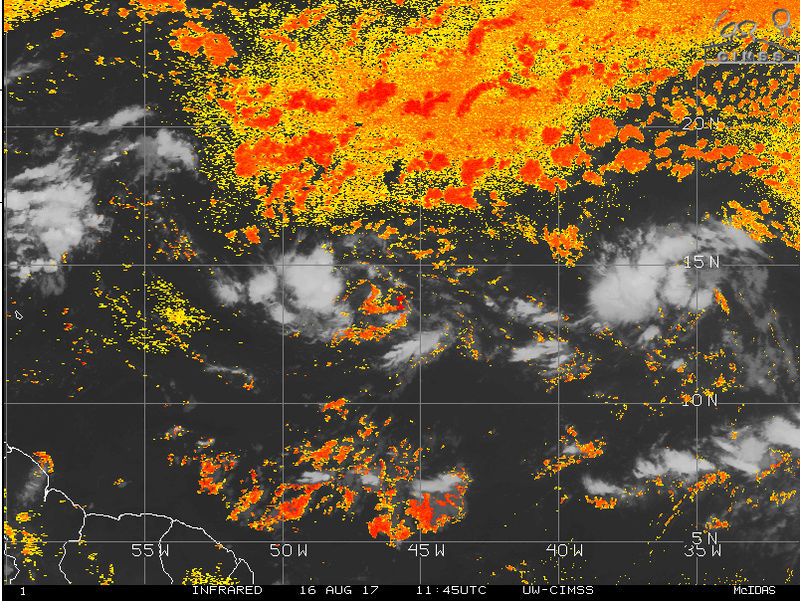
The dreaded SAL. Every time the convection tries to get going it gets knocked down by the dry air. With fairly decent conditions I expect both to cont to slowly develop over the next 3-5days but I dont expect a named storm unless the SAL conditions change.
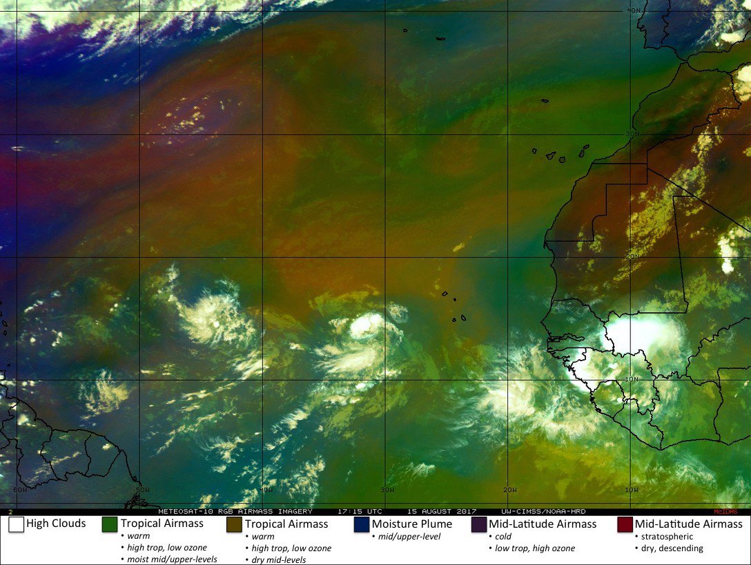
But look at the next two coming off Africa. 91L and 92L should help to saturate the atmosphere some out in front of these two waves.

_________________
"In weather and in life, there's no winning and losing; there's only winning and learning."
WINTER 2012/2013 TOTALS 43.65"WINTER 2017/2018 TOTALS 62.85" WINTER 2022/2023 TOTALS 4.9"
WINTER 2013/2014 TOTALS 64.85"WINTER 2018/2019 TOTALS 14.25" WINTER 2023/2024 TOTALS 13.1"
WINTER 2014/2015 TOTALS 71.20"WINTER 2019/2020 TOTALS 6.35"
WINTER 2015/2016 TOTALS 35.00"WINTER 2020/2021 TOTALS 37.75"
WINTER 2016/2017 TOTALS 42.25"WINTER 2021/2022 TOTALS 31.65"
sroc4- Admin
- Posts : 8331
Reputation : 301
Join date : 2013-01-07
Location : Wading River, LI
Re: 2017 General Tropical Cyclone Discussion Thread
![]() by sroc4 Wed Aug 16, 2017 11:35 am
by sroc4 Wed Aug 16, 2017 11:35 am


_________________
"In weather and in life, there's no winning and losing; there's only winning and learning."
WINTER 2012/2013 TOTALS 43.65"WINTER 2017/2018 TOTALS 62.85" WINTER 2022/2023 TOTALS 4.9"
WINTER 2013/2014 TOTALS 64.85"WINTER 2018/2019 TOTALS 14.25" WINTER 2023/2024 TOTALS 13.1"
WINTER 2014/2015 TOTALS 71.20"WINTER 2019/2020 TOTALS 6.35"
WINTER 2015/2016 TOTALS 35.00"WINTER 2020/2021 TOTALS 37.75"
WINTER 2016/2017 TOTALS 42.25"WINTER 2021/2022 TOTALS 31.65"
sroc4- Admin
- Posts : 8331
Reputation : 301
Join date : 2013-01-07
Location : Wading River, LI
Re: 2017 General Tropical Cyclone Discussion Thread
![]() by jmanley32 Wed Aug 16, 2017 12:02 pm
by jmanley32 Wed Aug 16, 2017 12:02 pm
jmanley32- Senior Enthusiast
- Posts : 20516
Reputation : 108
Join date : 2013-12-12
Age : 42
Location : Yonkers, NY
Re: 2017 General Tropical Cyclone Discussion Thread
![]() by algae888 Wed Aug 16, 2017 4:42 pm
by algae888 Wed Aug 16, 2017 4:42 pm


Last edited by algae888 on Wed Aug 16, 2017 4:49 pm; edited 1 time in total

algae888- Advanced Forecaster

- Posts : 5311
Reputation : 46
Join date : 2013-02-05
Age : 61
Location : mt. vernon, new york
Re: 2017 General Tropical Cyclone Discussion Thread
![]() by algae888 Wed Aug 16, 2017 4:45 pm
by algae888 Wed Aug 16, 2017 4:45 pm


ensembles agree
algae888- Advanced Forecaster
- Posts : 5311
Reputation : 46
Join date : 2013-02-05
Age : 61
Location : mt. vernon, new york
Re: 2017 General Tropical Cyclone Discussion Thread
![]() by algae888 Wed Aug 16, 2017 4:56 pm
by algae888 Wed Aug 16, 2017 4:56 pm

it does shift west during the next few days but the orientation or the trough (an strong one at that) over s/e Canada and the n/e will not steer a system towards the coast. to me conditions are not favorable for a east coast tropical system.


algae888- Advanced Forecaster
- Posts : 5311
Reputation : 46
Join date : 2013-02-05
Age : 61
Location : mt. vernon, new york
Re: 2017 General Tropical Cyclone Discussion Thread
![]() by algae888 Wed Aug 16, 2017 4:59 pm
by algae888 Wed Aug 16, 2017 4:59 pm

I should say as currently modeled and of coarse things can change.
algae888- Advanced Forecaster
- Posts : 5311
Reputation : 46
Join date : 2013-02-05
Age : 61
Location : mt. vernon, new york
Re: 2017 General Tropical Cyclone Discussion Thread
![]() by sroc4 Wed Aug 16, 2017 6:20 pm
by sroc4 Wed Aug 16, 2017 6:20 pm
algae888 wrote:
I should say as currently modeled and of coarse things can change.
Good to hear from you Al. Hope the summer is going well. I agree Love seeing those blues over the NE. It was funny as I was reading through what you posted I was thinking of responding with "as is currently modeled at 500mb", but then I got to your last line above. lol I agree as is currently modeled the trough digs and remains progressive. The timing of the 3rd system appears to find the weakness and gets caught up in said trough. The question is is does the trough split? and a piece lift up and out and a second trough back up in the mid west which would allow more ridging to build in over the top of the system steering it to the coast. Or does the system remain weak and take a more southerly track and miss the trough all together. As soon as that trough lifts out the ridge will rebuild. That did not happen with Gert. Plus and 91L and 92L are still very possible players for the US.
_________________
"In weather and in life, there's no winning and losing; there's only winning and learning."
WINTER 2012/2013 TOTALS 43.65"WINTER 2017/2018 TOTALS 62.85" WINTER 2022/2023 TOTALS 4.9"
WINTER 2013/2014 TOTALS 64.85"WINTER 2018/2019 TOTALS 14.25" WINTER 2023/2024 TOTALS 13.1"
WINTER 2014/2015 TOTALS 71.20"WINTER 2019/2020 TOTALS 6.35"
WINTER 2015/2016 TOTALS 35.00"WINTER 2020/2021 TOTALS 37.75"
WINTER 2016/2017 TOTALS 42.25"WINTER 2021/2022 TOTALS 31.65"
sroc4- Admin
- Posts : 8331
Reputation : 301
Join date : 2013-01-07
Location : Wading River, LI
Re: 2017 General Tropical Cyclone Discussion Thread
![]() by algae888 Wed Aug 16, 2017 7:27 pm
by algae888 Wed Aug 16, 2017 7:27 pm
algae888- Advanced Forecaster
- Posts : 5311
Reputation : 46
Join date : 2013-02-05
Age : 61
Location : mt. vernon, new york
Re: 2017 General Tropical Cyclone Discussion Thread
![]() by algae888 Wed Aug 16, 2017 8:47 pm
by algae888 Wed Aug 16, 2017 8:47 pm


I believe we will have to wait until September to see any chance of a east coast tropical system which is usual time frame for them.
algae888- Advanced Forecaster
- Posts : 5311
Reputation : 46
Join date : 2013-02-05
Age : 61
Location : mt. vernon, new york
Re: 2017 General Tropical Cyclone Discussion Thread
![]() by sroc4 Thu Aug 17, 2017 7:59 am
by sroc4 Thu Aug 17, 2017 7:59 am
algae888 wrote:Hey Scott doing well this summer has been fantastic so far not too much heat. I do feel that the trough will not be as Progressive as one might think. It enters our area at hour 150 on the operational and ensembles and does not exit until hour 240. It really digs as the pattern looks to amplify over the Eastern two-thirds of the country as a block looks to form near Green land and a closed low in the Gulf of Alaska. The trough could not come at a worse time as 91 l in 92 l if developed would be near our latitude and longitude att. And have nowhere to go but out to sea. We shall see.
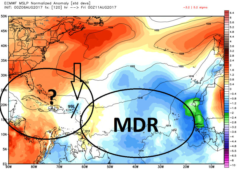
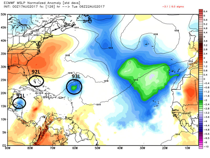
Hey Al. As of now I would have to agree with you regarding the set up with the rinse wash repeat strong progressive long wave troughs into the east. However; 91 and 92L will not be affected by that trough you mention. It would be 93L or whatever it is going to be designated that will likely. As you can see by the MSLP anomaly map below 91L will be in the Caribbean by Monday and 92L will be just N of the greater Antilles. Mean while 93L is hanging back not quite to 60w longitude yet.

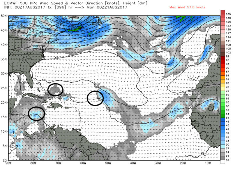
As you can see by the next two maps, 500mb at the same time frame, the ridge is still in control and the steering flow continues west for 92L towards SE Fla and 91L looks to cont west somewhere near the Yucatan Peninsula and eventually comes off the W Mexican coast and becomes a player in the SE Pac. There is an ULL trough feature in the GOM around this time frame that may be influential but we shall see. Both of these two systems cont to show anticyclonic flow over top throughout this time frame. Since this is still 4 days out, we need to cont to monitor both of these systems, because if they spin up that could change everything from there in the upper patterns. The incoming trough you mention could come into play for these two; more so 92L. They will be far enough west to potentially affect the US coast from the GOM to the SE coast.

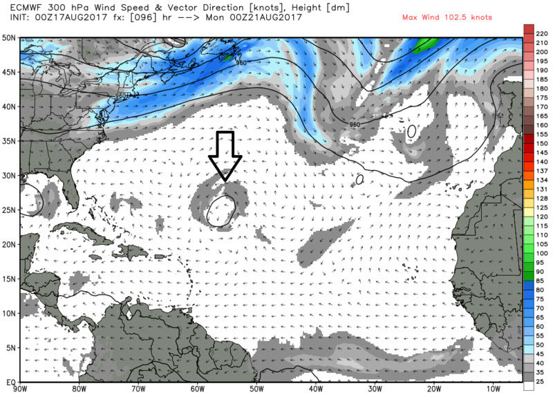
At this same time frame take a look at 300mb. There is an ULL over the vicinity of where 93L would be that is likely creating convergence aloft over top of 93L. Likely the reason the models cont to back down on how quickly and how strong that system gets going. 99L/Gert was similarly affected in this same geographic area by an ULL. It wasn't until that ULL broke down that 99L quickly became developed and Gert.
Bottome line is the Upper level pattern conts to evolve. Here is the differences at 500mb by the euro two days ago vs today for a week from now. Obs the sharpness of the trough and intensity of the system are drastically different.


I think the key time frame for this system will be around Tuesday of next week. (see below) Since the system has trended weaker when it reaches this longitude. Instead of a strong developed trop system that can recurve and bull its way through the weakness, if the weak trough I have labeled conts to trend weaker, faster, and or further N, then that would mean the ridging would be stronger and further N into the area I have circled "possibly" resulting in a track a tad further S and or more time to cont more west instead of NW, N, then NE once the next long wave trough digs(which recall has trended a bit weaker as indicated above).

Again for now Al I completely agree the pattern suggests a harmless recurve for 93L, but there are a few outs for a further west soln. 91L and 92L need to monitored closely because any significant changes in their forecasts could have implications down the road. For now that too is unlikely but again with 4days to go I will give it a few more days before I buy into any one soln on a model.
We track!!

_________________
"In weather and in life, there's no winning and losing; there's only winning and learning."
WINTER 2012/2013 TOTALS 43.65"WINTER 2017/2018 TOTALS 62.85" WINTER 2022/2023 TOTALS 4.9"
WINTER 2013/2014 TOTALS 64.85"WINTER 2018/2019 TOTALS 14.25" WINTER 2023/2024 TOTALS 13.1"
WINTER 2014/2015 TOTALS 71.20"WINTER 2019/2020 TOTALS 6.35"
WINTER 2015/2016 TOTALS 35.00"WINTER 2020/2021 TOTALS 37.75"
WINTER 2016/2017 TOTALS 42.25"WINTER 2021/2022 TOTALS 31.65"
sroc4- Admin
- Posts : 8331
Reputation : 301
Join date : 2013-01-07
Location : Wading River, LI
Re: 2017 General Tropical Cyclone Discussion Thread
![]() by jmanley32 Thu Aug 17, 2017 8:23 am
by jmanley32 Thu Aug 17, 2017 8:23 am
jmanley32- Senior Enthusiast
- Posts : 20516
Reputation : 108
Join date : 2013-12-12
Age : 42
Location : Yonkers, NY
Page 9 of 40 • 1 ... 6 ... 8, 9, 10 ... 24 ... 40 ![]()
|
|
|