
 Search
Tracking Hurricane Irma
Page 27 of 35 •  1 ... 15 ... 26, 27, 28 ... 31 ... 35
 ![]()
Re: Tracking Hurricane Irma
![]() by jmanley32 Tue Sep 05, 2017 8:38 am
by jmanley32 Tue Sep 05, 2017 8:38 am
It is fake (jk), the models are trying to trick us, watch it suddenly decides to run the coast in a few days and give us a TS or minimal hurricane. I think once we see that turn if there is one the models will start to show where she goes from there, it may not be before then. Just a opinion.Sanchize06 wrote:rb924119 wrote:Sanchize06 wrote:jmanley32 wrote:If they stay east into the carolinas, does that put us back in the threat as a coastal runner or will it still likely get pushed west inland, or do we still have no clue?Sanchize06 wrote:rb924119 wrote:Sanchize06 wrote:Majority of GEFS members look to still be east of Florida, heading for the Carolinas. Pretty big shift just from 0z. Still a long way to go for the East Coast.
Yeah the GFS is trying to keep the Eastern Seaboard in the game, but the 00z runs were mainly west, which I personally take more seriously than the off-hour 06/18z's
Yeah the 12z runs will be interesting
I still think there's a lot of time for a scenario where it goes into NC and comes north, but I guess we'll see. What's forcing it that far inland, the ridge?
Inland, or west?
Inland, I know the ridge is forcing it further to the west in the next couple of days, but what's preventing it from coming up the coast after landfall?

jmanley32- Senior Enthusiast

- Posts : 20513
Join date : 2013-12-12
Re: Tracking Hurricane Irma
![]() by rb924119 Tue Sep 05, 2017 8:42 am
by rb924119 Tue Sep 05, 2017 8:42 am
Sanchize06 wrote:rb924119 wrote:Sanchize06 wrote:jmanley32 wrote:If they stay east into the carolinas, does that put us back in the threat as a coastal runner or will it still likely get pushed west inland, or do we still have no clue?Sanchize06 wrote:rb924119 wrote:Sanchize06 wrote:Majority of GEFS members look to still be east of Florida, heading for the Carolinas. Pretty big shift just from 0z. Still a long way to go for the East Coast.
Yeah the GFS is trying to keep the Eastern Seaboard in the game, but the 00z runs were mainly west, which I personally take more seriously than the off-hour 06/18z's
Yeah the 12z runs will be interesting
I still think there's a lot of time for a scenario where it goes into NC and comes north, but I guess we'll see. What's forcing it that far inland, the ridge?
Inland, or west?
Inland, I know the ridge is forcing it further to the west in the next couple of days, but what's preventing it from coming up the coast after landfall?
The amount of interaction between itself and the shortwave trough diving into the central U.S. behind the big trough. The greater the interaction, the less likely to come up the coast. The less interaction, the further north the system can get before it eventually consolidates with the shortwave.
rb924119- Meteorologist

- Posts : 6889
Join date : 2013-02-06
Re: Tracking Hurricane Irma
![]() by rb924119 Tue Sep 05, 2017 8:45 am
by rb924119 Tue Sep 05, 2017 8:45 am
jmanley32 wrote:It is fake (jk), the models are trying to trick us, watch it suddenly decides to run the coast in a few days and give us a TS or minimal hurricane. I think once we see that turn if there is one the models will start to show where she goes from there, it may not be before then. Just a opinion.Sanchize06 wrote:rb924119 wrote:Sanchize06 wrote:jmanley32 wrote:If they stay east into the carolinas, does that put us back in the threat as a coastal runner or will it still likely get pushed west inland, or do we still have no clue?Sanchize06 wrote:rb924119 wrote:Sanchize06 wrote:Majority of GEFS members look to still be east of Florida, heading for the Carolinas. Pretty big shift just from 0z. Still a long way to go for the East Coast.
Yeah the GFS is trying to keep the Eastern Seaboard in the game, but the 00z runs were mainly west, which I personally take more seriously than the off-hour 06/18z's
Yeah the 12z runs will be interesting
I still think there's a lot of time for a scenario where it goes into NC and comes north, but I guess we'll see. What's forcing it that far inland, the ridge?
Inland, or west?
Inland, I know the ridge is forcing it further to the west in the next couple of days, but what's preventing it from coming up the coast after landfall?
 lol don't wish such a thing upon us aha (I know you're really not, don't worry, but would secretly like to experience the winds without any threat to life or property
rb924119- Meteorologist
- Posts : 6889
Reputation : 194
Join date : 2013-02-06
Age : 32
Location : Greentown, Pa
Re: Tracking Hurricane Irma
![]() by Sanchize06 Tue Sep 05, 2017 8:48 am
by Sanchize06 Tue Sep 05, 2017 8:48 am
rb924119 wrote:Sanchize06 wrote:rb924119 wrote:Sanchize06 wrote:jmanley32 wrote:If they stay east into the carolinas, does that put us back in the threat as a coastal runner or will it still likely get pushed west inland, or do we still have no clue?Sanchize06 wrote:rb924119 wrote:Sanchize06 wrote:Majority of GEFS members look to still be east of Florida, heading for the Carolinas. Pretty big shift just from 0z. Still a long way to go for the East Coast.
Yeah the GFS is trying to keep the Eastern Seaboard in the game, but the 00z runs were mainly west, which I personally take more seriously than the off-hour 06/18z's
Yeah the 12z runs will be interesting
I still think there's a lot of time for a scenario where it goes into NC and comes north, but I guess we'll see. What's forcing it that far inland, the ridge?
Inland, or west?
Inland, I know the ridge is forcing it further to the west in the next couple of days, but what's preventing it from coming up the coast after landfall?
The amount of interaction between itself and the shortwave trough diving into the central U.S. behind the big trough. The greater the interaction, the less likely to come up the coast. The less interaction, the further north the system can get before it eventually consolidates with the shortwave.
Okay thanks that makes sense. What about Jose? Is there any chance he weakens the ridge out east and allows for a quicker north turn?
Sanchize06- Senior Enthusiast
- Posts : 1041
Reputation : 21
Join date : 2013-02-05
Location : Union Beach, NJ
Re: Tracking Hurricane Irma
![]() by jmanley32 Tue Sep 05, 2017 8:48 am
by jmanley32 Tue Sep 05, 2017 8:48 am
Nah, I think we prolly escapes us but its still possible I guess.rb924119 wrote:jmanley32 wrote:It is fake (jk), the models are trying to trick us, watch it suddenly decides to run the coast in a few days and give us a TS or minimal hurricane. I think once we see that turn if there is one the models will start to show where she goes from there, it may not be before then. Just a opinion.Sanchize06 wrote:rb924119 wrote:Sanchize06 wrote:jmanley32 wrote:If they stay east into the carolinas, does that put us back in the threat as a coastal runner or will it still likely get pushed west inland, or do we still have no clue?Sanchize06 wrote:rb924119 wrote:Sanchize06 wrote:Majority of GEFS members look to still be east of Florida, heading for the Carolinas. Pretty big shift just from 0z. Still a long way to go for the East Coast.
Yeah the GFS is trying to keep the Eastern Seaboard in the game, but the 00z runs were mainly west, which I personally take more seriously than the off-hour 06/18z's
Yeah the 12z runs will be interesting
I still think there's a lot of time for a scenario where it goes into NC and comes north, but I guess we'll see. What's forcing it that far inland, the ridge?
Inland, or west?
Inland, I know the ridge is forcing it further to the west in the next couple of days, but what's preventing it from coming up the coast after landfall?)

jmanley32- Senior Enthusiast
- Posts : 20513
Reputation : 108
Join date : 2013-12-12
Age : 42
Location : Yonkers, NY
Re: Tracking Hurricane Irma
![]() by sroc4 Tue Sep 05, 2017 8:52 am
by sroc4 Tue Sep 05, 2017 8:52 am
First is that ridge over Texas, and second is the mean trough. I do ot believe modeling is handling the nature of the mean trough very well at all, and additional changes in the modeling are afoot as we move ahead. Notice the 48hr trends on the GFS. The trend is to nose the higher heights stronger and further east over Texas, and also the trend is to build higher heights into the mid Atlantic faster. I still think highest probability is a landfall between N Georgia to OBX with the EC of Fla still at risk for significant effects.


_________________
"In weather and in life, there's no winning and losing; there's only winning and learning."
WINTER 2012/2013 TOTALS 43.65"WINTER 2017/2018 TOTALS 62.85" WINTER 2022/2023 TOTALS 4.9"
WINTER 2013/2014 TOTALS 64.85"WINTER 2018/2019 TOTALS 14.25" WINTER 2023/2024 TOTALS 13.1"
WINTER 2014/2015 TOTALS 71.20"WINTER 2019/2020 TOTALS 6.35"
WINTER 2015/2016 TOTALS 35.00"WINTER 2020/2021 TOTALS 37.75"
WINTER 2016/2017 TOTALS 42.25"WINTER 2021/2022 TOTALS 31.65"

sroc4- Admin

- Posts : 8331
Reputation : 301
Join date : 2013-01-07
Location : Wading River, LI
Re: Tracking Hurricane Irma
![]() by jmanley32 Tue Sep 05, 2017 8:55 am
by jmanley32 Tue Sep 05, 2017 8:55 am
I know others have keyed in but if you feel GA to OBX is the area, will she continue north from there or veer sharply west like some model runs have shown? Just want ur opinion, if you alrady answered sorry I am tired and been trying to talk to a million people about this LOLsroc4 wrote:Ray we are going to have to watch two key features very closely if your theory of a eastern Gulf track comes to fruition.
First is that ridge over Texas, and second is the mean trough. I do ot believe modeling is handling the nature of the mean trough very well at all, and additional changes in the modeling are afoot as we move ahead. Notice the 48hr trends on the GFS. The trend is to nose the higher heights stronger and further east over Texas, and also the trend is to build higher heights into the mid Atlantic faster. I still think highest probability is a landfall between N Georgia to OBX with the EC of Fla still at risk for significant effects.
jmanley32- Senior Enthusiast
- Posts : 20513
Reputation : 108
Join date : 2013-12-12
Age : 42
Location : Yonkers, NY
Re: Tracking Hurricane Irma
![]() by sroc4 Tue Sep 05, 2017 9:00 am
by sroc4 Tue Sep 05, 2017 9:00 am
_________________
"In weather and in life, there's no winning and losing; there's only winning and learning."
WINTER 2012/2013 TOTALS 43.65"WINTER 2017/2018 TOTALS 62.85" WINTER 2022/2023 TOTALS 4.9"
WINTER 2013/2014 TOTALS 64.85"WINTER 2018/2019 TOTALS 14.25" WINTER 2023/2024 TOTALS 13.1"
WINTER 2014/2015 TOTALS 71.20"WINTER 2019/2020 TOTALS 6.35"
WINTER 2015/2016 TOTALS 35.00"WINTER 2020/2021 TOTALS 37.75"
WINTER 2016/2017 TOTALS 42.25"WINTER 2021/2022 TOTALS 31.65"
sroc4- Admin
- Posts : 8331
Reputation : 301
Join date : 2013-01-07
Location : Wading River, LI
Re: Tracking Hurricane Irma
![]() by sroc4 Tue Sep 05, 2017 9:01 am
by sroc4 Tue Sep 05, 2017 9:01 am
_________________
"In weather and in life, there's no winning and losing; there's only winning and learning."
WINTER 2012/2013 TOTALS 43.65"WINTER 2017/2018 TOTALS 62.85" WINTER 2022/2023 TOTALS 4.9"
WINTER 2013/2014 TOTALS 64.85"WINTER 2018/2019 TOTALS 14.25" WINTER 2023/2024 TOTALS 13.1"
WINTER 2014/2015 TOTALS 71.20"WINTER 2019/2020 TOTALS 6.35"
WINTER 2015/2016 TOTALS 35.00"WINTER 2020/2021 TOTALS 37.75"
WINTER 2016/2017 TOTALS 42.25"WINTER 2021/2022 TOTALS 31.65"
sroc4- Admin
- Posts : 8331
Reputation : 301
Join date : 2013-01-07
Location : Wading River, LI
Re: Tracking Hurricane Irma
![]() by Frank_Wx Tue Sep 05, 2017 9:02 am
by Frank_Wx Tue Sep 05, 2017 9:02 am
sroc4 wrote:Ray we are going to have to watch two key features very closely if your theory of a eastern Gulf track comes to fruition.
First is that ridge over Texas, and second is the mean trough. I do ot believe modeling is handling the nature of the mean trough very well at all, and additional changes in the modeling are afoot as we move ahead. Notice the 48hr trends on the GFS. The trend is to nose the higher heights stronger and further east over Texas, and also the trend is to build higher heights into the mid Atlantic faster. I still think highest probability is a landfall between N Georgia to OBX with the EC of Fla still at risk for significant effects.
sroc4 wrote:Jman there is still so much uncertainty beyond day 4-5 that I don't know where it goes beyond that. It could come up the coast or OTS or cont inland and west. It all depends on what the steering layers look like at that time.
Agree.
_________________
_______________________________________________________________________________________________________
CLICK HERE to view NJ Strong Snowstorm Classifications

Frank_Wx- Godzilla Seeker
- Posts : 21305
Reputation : 328
Join date : 2013-01-05
Age : 31
Location : Jersey City, NJ -

Re: Tracking Hurricane Irma
![]() by Frank_Wx Tue Sep 05, 2017 9:04 am
by Frank_Wx Tue Sep 05, 2017 9:04 am

_________________
_______________________________________________________________________________________________________
CLICK HERE to view NJ Strong Snowstorm Classifications
Frank_Wx- Godzilla Seeker
- Posts : 21305
Reputation : 328
Join date : 2013-01-05
Age : 31
Location : Jersey City, NJ -
Re: Tracking Hurricane Irma
![]() by Frank_Wx Tue Sep 05, 2017 9:11 am
by Frank_Wx Tue Sep 05, 2017 9:11 am
.thumb.png.780e7e8ea083557a848fc68719c8604c.png)
_________________
_______________________________________________________________________________________________________
CLICK HERE to view NJ Strong Snowstorm Classifications
Frank_Wx- Godzilla Seeker
- Posts : 21305
Reputation : 328
Join date : 2013-01-05
Age : 31
Location : Jersey City, NJ -
Re: Tracking Hurricane Irma
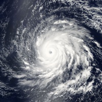
![]() by jmanley32 Tue Sep 05, 2017 9:22 am
by jmanley32 Tue Sep 05, 2017 9:22 am
wow that's amazing. Any chance we see a double eyewall?Frank_Wx wrote:
jmanley32- Senior Enthusiast
- Posts : 20513
Reputation : 108
Join date : 2013-12-12
Age : 42
Location : Yonkers, NY
Re: Tracking Hurricane Irma
![]() by aiannone Tue Sep 05, 2017 9:22 am
by aiannone Tue Sep 05, 2017 9:22 am
KING NAM LOL!Frank_Wx wrote:Starting to see east trends
_________________
-Alex Iannone-

aiannone- Senior Enthusiast - Mod

- Posts : 4813
Reputation : 92
Join date : 2013-01-07
Location : Saint James, LI (Northwest Suffolk Co.)
Re: Tracking Hurricane Irma
![]() by jmanley32 Tue Sep 05, 2017 9:23 am
by jmanley32 Tue Sep 05, 2017 9:23 am
okay wasn't sure if we would have a better idea or not yet. So by what like Fri to sun maybe we know?Frank_Wx wrote:sroc4 wrote:Ray we are going to have to watch two key features very closely if your theory of a eastern Gulf track comes to fruition.
First is that ridge over Texas, and second is the mean trough. I do ot believe modeling is handling the nature of the mean trough very well at all, and additional changes in the modeling are afoot as we move ahead. Notice the 48hr trends on the GFS. The trend is to nose the higher heights stronger and further east over Texas, and also the trend is to build higher heights into the mid Atlantic faster. I still think highest probability is a landfall between N Georgia to OBX with the EC of Fla still at risk for significant effects.sroc4 wrote:Jman there is still so much uncertainty beyond day 4-5 that I don't know where it goes beyond that. It could come up the coast or OTS or cont inland and west. It all depends on what the steering layers look like at that time.
Agree.
jmanley32- Senior Enthusiast
- Posts : 20513
Reputation : 108
Join date : 2013-12-12
Age : 42
Location : Yonkers, NY
Re: Tracking Hurricane Irma
![]() by rb924119 Tue Sep 05, 2017 9:27 am
by rb924119 Tue Sep 05, 2017 9:27 am
Frank_Wx wrote:Starting to see east trends
It's identical to 00z with regard to the mean, but has more a cluster to the west than 00z. Idk if I'd call this a trend lol
rb924119- Meteorologist
- Posts : 6889
Reputation : 194
Join date : 2013-02-06
Age : 32
Location : Greentown, Pa
Re: Tracking Hurricane Irma
![]() by rb924119 Tue Sep 05, 2017 9:31 am
by rb924119 Tue Sep 05, 2017 9:31 am
sroc4 wrote:Ray we are going to have to watch two key features very closely if your theory of a eastern Gulf track comes to fruition.
First is that ridge over Texas, and second is the mean trough. I do ot believe modeling is handling the nature of the mean trough very well at all, and additional changes in the modeling are afoot as we move ahead. Notice the 48hr trends on the GFS. The trend is to nose the higher heights stronger and further east over Texas, and also the trend is to build higher heights into the mid Atlantic faster. I still think highest probability is a landfall between N Georgia to OBX with the EC of Fla still at risk for significant effects.
I agree with the ridge part, but that should erode. The mean trough I think is a mute point at this time. The hurricane doesn't know that trough exists because of the ridge building in over top of it as that trough lifts out. The second player is the shortwave coming down the eastern flank of the decaying ridge, which should erode the eastern flank and interact with Irma. That's why I think it ends up there. If you saw my update yesterday I explained it in more detail.
rb924119- Meteorologist
- Posts : 6889
Reputation : 194
Join date : 2013-02-06
Age : 32
Location : Greentown, Pa

rb924119- Meteorologist
- Posts : 6889
Reputation : 194
Join date : 2013-02-06
Age : 32
Location : Greentown, Pa
Re: Tracking Hurricane Irma
![]() by rb924119 Tue Sep 05, 2017 9:36 am
by rb924119 Tue Sep 05, 2017 9:36 am
rb924119- Meteorologist
- Posts : 6889
Reputation : 194
Join date : 2013-02-06
Age : 32
Location : Greentown, Pa
Re: Tracking Hurricane Irma
![]() by amugs Tue Sep 05, 2017 9:54 am
by amugs Tue Sep 05, 2017 9:54 am

_________________
Mugs
AKA:King: Snow Weenie
Self Proclaimed
WINTER 2014-15 : 55.12" +.02 for 6 coatings (avg. 35")
WINTER 2015-16 Total - 29.8" (Avg 35")
WINTER 2016-17 : 39.5" so far

amugs- Advanced Forecaster - Mod
- Posts : 15093
Reputation : 213
Join date : 2013-01-07
Age : 54
Location : Hillsdale,NJ
Re: Tracking Hurricane Irma
![]() by jmanley32 Tue Sep 05, 2017 9:59 am
by jmanley32 Tue Sep 05, 2017 9:59 am
well that clears things up lolamugs wrote:
jmanley32- Senior Enthusiast
- Posts : 20513
Reputation : 108
Join date : 2013-12-12
Age : 42
Location : Yonkers, NY
Re: Tracking Hurricane Irma
![]() by sroc4 Tue Sep 05, 2017 10:03 am
by sroc4 Tue Sep 05, 2017 10:03 am
rb924119 wrote:Scott:
Of course this is assuming Irma makes it this far S and West .
_________________
"In weather and in life, there's no winning and losing; there's only winning and learning."
WINTER 2012/2013 TOTALS 43.65"WINTER 2017/2018 TOTALS 62.85" WINTER 2022/2023 TOTALS 4.9"
WINTER 2013/2014 TOTALS 64.85"WINTER 2018/2019 TOTALS 14.25" WINTER 2023/2024 TOTALS 13.1"
WINTER 2014/2015 TOTALS 71.20"WINTER 2019/2020 TOTALS 6.35"
WINTER 2015/2016 TOTALS 35.00"WINTER 2020/2021 TOTALS 37.75"
WINTER 2016/2017 TOTALS 42.25"WINTER 2021/2022 TOTALS 31.65"
sroc4- Admin
- Posts : 8331
Reputation : 301
Join date : 2013-01-07
Location : Wading River, LI
Re: Tracking Hurricane Irma
![]() by rb924119 Tue Sep 05, 2017 10:05 am
by rb924119 Tue Sep 05, 2017 10:05 am
sroc4 wrote:rb924119 wrote:Scott:
Of course this is assuming Irma makes it this far S and West .
You are not wrong ahahahaha
rb924119- Meteorologist
- Posts : 6889
Reputation : 194
Join date : 2013-02-06
Age : 32
Location : Greentown, Pa
Re: Tracking Hurricane Irma
![]() by amugs Tue Sep 05, 2017 10:36 am
by amugs Tue Sep 05, 2017 10:36 am

_________________
Mugs
AKA:King: Snow Weenie
Self Proclaimed
WINTER 2014-15 : 55.12" +.02 for 6 coatings (avg. 35")
WINTER 2015-16 Total - 29.8" (Avg 35")
WINTER 2016-17 : 39.5" so far
amugs- Advanced Forecaster - Mod
- Posts : 15093
Reputation : 213
Join date : 2013-01-07
Age : 54
Location : Hillsdale,NJ

RJB8525- Senior Enthusiast
- Posts : 1994
Reputation : 28
Join date : 2013-02-06
Age : 38
Location : Hackettstown, NJ
Re: Tracking Hurricane Irma
![]() by jwalsh Tue Sep 05, 2017 10:47 am
by jwalsh Tue Sep 05, 2017 10:47 am
jwalsh- Posts : 60
Reputation : 0
Join date : 2016-01-18
Location : Commack, NY
Page 27 of 35 • 1 ... 15 ... 26, 27, 28 ... 31 ... 35 ![]()
|
|
|