
 Search
Long Range Thread 15.0
Page 2 of 42 •  1, 2, 3 ... 22 ... 42
 ![]()
Re: Long Range Thread 15.0
![]() by amugs Wed Sep 27, 2017 2:10 pm
by amugs Wed Sep 27, 2017 2:10 pm
amugs- Advanced Forecaster - Mod

- Posts : 15095
Join date : 2013-01-07
Re: Long Range Thread 15.0
![]() by Isotherm Thu Sep 28, 2017 11:02 pm
by Isotherm Thu Sep 28, 2017 11:02 pm
amugs wrote:Isotherm wrote:I am watching Agungo closely. If it looks like we're going to see a VEI 5+ eruption, there is quite a bit of research out there regarding the atmospheric modulatory effects tropospherically, stratospherically, worldwide. What's interesting as well is that the previous major tropical volcanic eruptions occurred in El Nino events - 1963 Agungo, as moderate el nino initiated; 1982 El Chichon - as strong el nino began; and 1991 Pinatubo - as strong el nino initiated. The respective ENSO states countervailed the year 1 cooling induced by those volcanoes (delay to year 2) such that net was near zero. However, this could be a unique situation in which we see a major eruption coincident with a developing weak to moderate La Nina. Those mechanisms would act adjunctively / cumulatively as far as cooling effects induced globally, possibly yielding an even stronger cooling signal. Of course, there are a lot of IFs here, including La Nina intensity, VEI, evolution of the event, does it occur, etc.
Awesome post and I was reading an article about as we have talked about before Tim that corelation between low.solar and seismic high activity - eq and volcanoes. It would be something to see anologies if we have any for a nina and such a massive expoison if one were to be.
Thank you mugs, and agreed it would be very fascinating to watch this unfold. The meteorology/weather enthusiast community has never experienced a VEI 5+ tropical volcanic eruption with today's technology / internet, etc. Would be fun to track the impending modulation of weather on a micro and macro scale.
Isotherm- Advanced Forecaster

- Posts : 231
Join date : 2014-09-01 -

Re: Long Range Thread 15.0
![]() by amugs Sat Sep 30, 2017 8:27 am
by amugs Sat Sep 30, 2017 8:27 am
_________________
Mugs
AKA:King: Snow Weenie
Self Proclaimed
WINTER 2014-15 : 55.12" +.02 for 6 coatings (avg. 35")
WINTER 2015-16 Total - 29.8" (Avg 35")
WINTER 2016-17 : 39.5" so far

amugs- Advanced Forecaster - Mod
- Posts : 15095
Reputation : 213
Join date : 2013-01-07
Age : 54
Location : Hillsdale,NJ
Re: Long Range Thread 15.0
![]() by CPcantmeasuresnow Mon Oct 02, 2017 12:37 am
by CPcantmeasuresnow Mon Oct 02, 2017 12:37 am
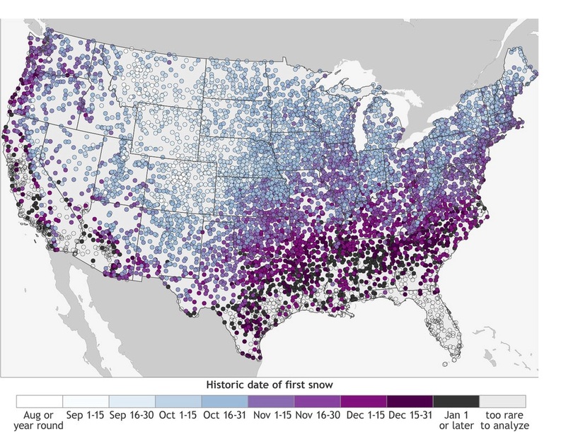
amugs wrote:Okay here is the 1st date of average snowfall map for our area and the USA!!
Mugs:
Is this average for the first Trace of snow, or measurable snow?

CPcantmeasuresnow- Wx Statistician Guru

- Posts : 7274
Reputation : 230
Join date : 2013-01-07
Age : 103
Location : Eastern Orange County, NY
Re: Long Range Thread 15.0
![]() by amugs Mon Oct 02, 2017 7:04 am
by amugs Mon Oct 02, 2017 7:04 am
CPcantmeasuresnow wrote:amugs wrote:Okay here is the 1st date of average snowfall map for our area and the USA!!
Is this average for the first Trace of snow, or measurable snow?
Good question. Honestly don't know it just said from the site average time period of 1st snowfall.
Mugs:
_________________
Mugs
AKA:King: Snow Weenie
Self Proclaimed
WINTER 2014-15 : 55.12" +.02 for 6 coatings (avg. 35")
WINTER 2015-16 Total - 29.8" (Avg 35")
WINTER 2016-17 : 39.5" so far
amugs- Advanced Forecaster - Mod
- Posts : 15095
Reputation : 213
Join date : 2013-01-07
Age : 54
Location : Hillsdale,NJ
Re: Long Range Thread 15.0
![]() by amugs Mon Oct 02, 2017 11:45 am
by amugs Mon Oct 02, 2017 11:45 am

_________________
Mugs
AKA:King: Snow Weenie
Self Proclaimed
WINTER 2014-15 : 55.12" +.02 for 6 coatings (avg. 35")
WINTER 2015-16 Total - 29.8" (Avg 35")
WINTER 2016-17 : 39.5" so far
amugs- Advanced Forecaster - Mod
- Posts : 15095
Reputation : 213
Join date : 2013-01-07
Age : 54
Location : Hillsdale,NJ
Re: Long Range Thread 15.0
![]() by amugs Mon Oct 02, 2017 11:54 am
by amugs Mon Oct 02, 2017 11:54 am
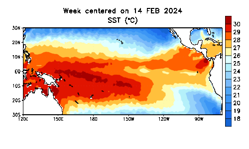
13SEP2017 19.7-0.7 24.0-0.9 26.1-0.6 28.7 0.0
20SEP2017 19.3-1.1 23.9-1.0 26.3-0.4 28.7 0.0
27SEP2017 19.5-1.0 24.4-0.5 26.5-0.2 28.4-0.2
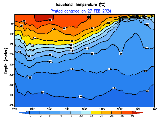
Lots of warm PAC Water by the dateline and just east though you see a cold tongue trying to move west
_________________
Mugs
AKA:King: Snow Weenie
Self Proclaimed
WINTER 2014-15 : 55.12" +.02 for 6 coatings (avg. 35")
WINTER 2015-16 Total - 29.8" (Avg 35")
WINTER 2016-17 : 39.5" so far
amugs- Advanced Forecaster - Mod
- Posts : 15095
Reputation : 213
Join date : 2013-01-07
Age : 54
Location : Hillsdale,NJ
Re: Long Range Thread 15.0
![]() by algae888 Mon Oct 02, 2017 4:45 pm
by algae888 Mon Oct 02, 2017 4:45 pm


so while we may end up with a weak to moderate nina will our sensible weather end up la nina like. ie; s/e ridge western trough? i am not sold on this winter acting like a typical nina. pac to warm.

algae888- Advanced Forecaster
- Posts : 5311
Reputation : 46
Join date : 2013-02-05
Age : 62
Location : mt. vernon, new york
Re: Long Range Thread 15.0
![]() by algae888 Mon Oct 02, 2017 4:50 pm
by algae888 Mon Oct 02, 2017 4:50 pm
gfs close to our first fantasy storm....

algae888- Advanced Forecaster
- Posts : 5311
Reputation : 46
Join date : 2013-02-05
Age : 62
Location : mt. vernon, new york
Re: Long Range Thread 15.0
![]() by amugs Mon Oct 02, 2017 5:22 pm
by amugs Mon Oct 02, 2017 5:22 pm
East based Nina''s are good for the North East and MA regions with a Easterly QBO. Not all the ingredients for a bang bang winter but two in the right camp. PDO looks like a horeshoe or warmth overall. Still time. Looks like middle of the month changes to get things interesting in a dynamical fall way.
_________________
Mugs
AKA:King: Snow Weenie
Self Proclaimed
WINTER 2014-15 : 55.12" +.02 for 6 coatings (avg. 35")
WINTER 2015-16 Total - 29.8" (Avg 35")
WINTER 2016-17 : 39.5" so far
amugs- Advanced Forecaster - Mod
- Posts : 15095
Reputation : 213
Join date : 2013-01-07
Age : 54
Location : Hillsdale,NJ
Re: Long Range Thread 15.0
![]() by amugs Mon Oct 02, 2017 5:52 pm
by amugs Mon Oct 02, 2017 5:52 pm
_________________
Mugs
AKA:King: Snow Weenie
Self Proclaimed
WINTER 2014-15 : 55.12" +.02 for 6 coatings (avg. 35")
WINTER 2015-16 Total - 29.8" (Avg 35")
WINTER 2016-17 : 39.5" so far
amugs- Advanced Forecaster - Mod
- Posts : 15095
Reputation : 213
Join date : 2013-01-07
Age : 54
Location : Hillsdale,NJ
Re: Long Range Thread 15.0
![]() by amugs Mon Oct 02, 2017 6:11 pm
by amugs Mon Oct 02, 2017 6:11 pm
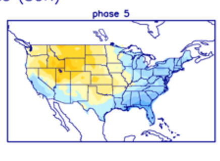
MJO phases

Phase 5 map
_________________
Mugs
AKA:King: Snow Weenie
Self Proclaimed
WINTER 2014-15 : 55.12" +.02 for 6 coatings (avg. 35")
WINTER 2015-16 Total - 29.8" (Avg 35")
WINTER 2016-17 : 39.5" so far
amugs- Advanced Forecaster - Mod
- Posts : 15095
Reputation : 213
Join date : 2013-01-07
Age : 54
Location : Hillsdale,NJ
Re: Long Range Thread 15.0
![]() by dkodgis Wed Oct 04, 2017 1:33 pm
by dkodgis Wed Oct 04, 2017 1:33 pm

dkodgis- Senior Enthusiast

- Posts : 2560
Reputation : 98
Join date : 2013-12-29
Re: Long Range Thread 15.0
![]() by Frank_Wx Mon Oct 09, 2017 8:04 am
by Frank_Wx Mon Oct 09, 2017 8:04 am

_________________
_______________________________________________________________________________________________________
CLICK HERE to view NJ Strong Snowstorm Classifications

Frank_Wx- Godzilla Seeker

- Posts : 21305
Reputation : 328
Join date : 2013-01-05
Age : 32
Location : Jersey City, NJ -
Re: Long Range Thread 15.0
![]() by jmanley32 Tue Oct 10, 2017 6:36 am
by jmanley32 Tue Oct 10, 2017 6:36 am
This is nuts I know one place that's loving it. The electric companies cuz so many are still using ac. I for one am not and I read on another forum that warmth could last into nov. And from there not completely sure. I'm not a global warming person but what do you call this? It's not the first year.Frank_Wx wrote:SE Ridge is not backing down. Another week of mild temperatures. Though by the end of the week looks like there will be an onshore flow keeping temps in the 60's, but it will still be humid. By Saturday, could get to 80 again.

jmanley32- Senior Enthusiast
- Posts : 20535
Reputation : 108
Join date : 2013-12-12
Age : 43
Location : Yonkers, NY
Re: Long Range Thread 15.0
![]() by HectorO Tue Oct 10, 2017 4:33 pm
by HectorO Tue Oct 10, 2017 4:33 pm
jmanley32 wrote:This is nuts I know one place that's loving it. The electric companies cuz so many are still using ac. I for one am not and I read on another forum that warmth could last into nov. And from there not completely sure. I'm not a global warming person but what do you call this? It's not the first year.Frank_Wx wrote:SE Ridge is not backing down. Another week of mild temperatures. Though by the end of the week looks like there will be an onshore flow keeping temps in the 60's, but it will still be humid. By Saturday, could get to 80 again.
Meteorologists must have seen something. Before September got under way they were calling for a warm fall. I like stopped using my A.C but I had to use it yesterday to draw out some of the humidity.

HectorO- Pro Enthusiast

- Posts : 962
Reputation : 27
Join date : 2013-01-11
Re: Long Range Thread 15.0
![]() by rb924119 Tue Oct 10, 2017 6:27 pm
by rb924119 Tue Oct 10, 2017 6:27 pm
rb924119- Meteorologist

- Posts : 6928
Reputation : 194
Join date : 2013-02-06
Age : 32
Location : Greentown, Pa
Re: Long Range Thread 15.0
![]() by Frank_Wx Wed Oct 11, 2017 9:21 am
by Frank_Wx Wed Oct 11, 2017 9:21 am
rb924119 wrote:For those that would like to expand on this please use this as a springboard, but we have an interesting and fantastic educational situation unfolding with regard to our general pattern over the next couple of weeks; one that I've been waiting for to show its face. I'm referencing the discussion of what makes a particular atmospheric "player" a pattern driver versus a pattern enhancer. As Scott as has pointed out several days ago, and reiterating my previous points in addition to his, the SOI has been in a very persistent basestate for some time now, which promotes time-mean ridging in eastern North America, much like we are seeing in the modeling over the next two weeks. However, the MJO is unanimously progged to enter strongly into phases 4 and 5. Phase promotes widespread cool across the CONUS, while 5 promotes more significant cold east of the Mississippi in the month of October. This is in complete contrast to the recent stretch of ++SOI values, which begs the question: Which way will our pattern go? Will it follow the ridging induced by the SOI, or, the troughing evidenced by the strong MJO pulse? The answer is not necessarily mutually exclusive; rather, an "if-then" and "but". If you look at the trends in the modeling, you can clearly see how the ~Day 6-8 troughing is trending increasingly stronger as it comes into the East, supporting the simultaneous traversal of the poten MJO pulse into Phase 5. However, also note that this trough is both transient and surrounded by a "sea of warmth" in the time-mean, supported by the ++SOI. When looking at the mean temperatures over the next two weeks, you can see that even with this trough trending stronger thanks to the MJO, the temperature anomalies remain strongly positive, owing to the ++SOI. My point? This shows that the much larger SOI, which encompasses the entirety of the tropical Pacific, is a much larger influence on our synoptic pattern (a driver), than the MJO, which only incorporates/occupies *one section* of the tropical Pacific at any given time (a pattern enhancer).
Great post. I agree with everything. There will be times over the next 2 weeks (not including this one) where we'll see fall-like and possibly below normal temps. But it will be very transient. There is a sign from the GEFS we could get into a stretch of fall weather around Halloween. But that is very far down the road and could change.

_________________
_______________________________________________________________________________________________________
CLICK HERE to view NJ Strong Snowstorm Classifications
Frank_Wx- Godzilla Seeker
- Posts : 21305
Reputation : 328
Join date : 2013-01-05
Age : 32
Location : Jersey City, NJ -
Re: Long Range Thread 15.0
![]() by sroc4 Wed Oct 11, 2017 9:25 am
by sroc4 Wed Oct 11, 2017 9:25 am
jmanley32 wrote:This is nuts I know one place that's loving it. The electric companies cuz so many are still using ac. I for one am not and I read on another forum that warmth could last into nov. And from there not completely sure. I'm not a global warming person but what do you call this? It's not the first year.Frank_Wx wrote:SE Ridge is not backing down. Another week of mild temperatures. Though by the end of the week looks like there will be an onshore flow keeping temps in the 60's, but it will still be humid. By Saturday, could get to 80 again.
Obviously In recent years warmer than normal relative to "Avg", meaning the 1981-2010 averages temp anomalies have plagued us. However; what we are experiencing right now is not all that unusual given the current status of the Trop Pac. A persistent SOI and La Nina like base state, although we are not currently officially in a La Nina and may not truly get there, has been a primary driver to our weather pattern as of late, as Ray stated above, with very little esle going on on a large scale to alter said pattern. Tropics are quite strat doesnt come into play for another 1-1.5months etc. BTW great post Ray. Also like Ray mentioned a very strong pulse in the MJO region from 4 where we are now (warm in the east) into 5 and maybe 6 is unanimously forecasted right now. I personally believe the base state of the emerging weak La Nina will dominate the overall pattern, but the MJO pulse will give us our shots of transient below normal weather in the 7-14d. Also the possible recurving typhoon in the 6-10d, if comes to fruition, will likely become a fly in the ointment, or short term pattern enhancer/modifier as well. So with that said the persistent ridging the Eastern half the country has been experiencing, and that is forecasted to continue to be where the pattern settles back into after our transients cool shots, and will likely cont until we get later in the season when wavelengths shorten, and other pattern enhancers/drivers come into play.
FWIW. JB on the Bell posted this yesterday. Here are the temp anomalies through the Month of Oct thus far as well as the temp anomalies for the same time frame through Oct in 2013. Pretty much identical.
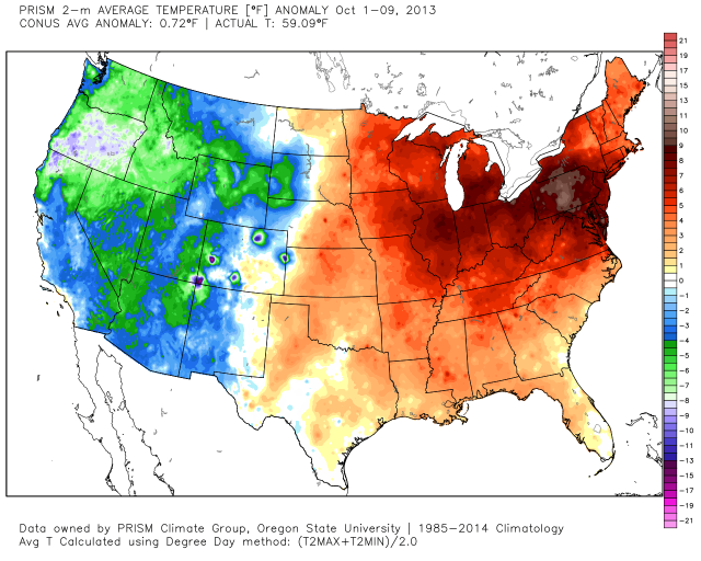
Oct 2013 we were headed into a similar ENSO period as we are forecasted to this season as well. IE: A neg neutral ENSO that remained weakly negative throughout the season as seen on the ONI. So a negatively leaning neutral ENSO period which might happen this year as well. Just some food for thought.
http://origin.cpc.ncep.noaa.gov/products/analysis_monitoring/ensostuff/ONI_v5.php
Last edited by sroc4 on Wed Oct 11, 2017 10:10 am; edited 1 time in total
_________________
"In weather and in life, there's no winning and losing; there's only winning and learning."
WINTER 2012/2013 TOTALS 43.65"WINTER 2017/2018 TOTALS 62.85" WINTER 2022/2023 TOTALS 4.9"
WINTER 2013/2014 TOTALS 64.85"WINTER 2018/2019 TOTALS 14.25" WINTER 2023/2024 TOTALS 13.1"
WINTER 2014/2015 TOTALS 71.20"WINTER 2019/2020 TOTALS 6.35"
WINTER 2015/2016 TOTALS 35.00"WINTER 2020/2021 TOTALS 37.75"
WINTER 2016/2017 TOTALS 42.25"WINTER 2021/2022 TOTALS 31.65"

sroc4- Admin
- Posts : 8354
Reputation : 302
Join date : 2013-01-07
Location : Wading River, LI
Re: Long Range Thread 15.0
![]() by sroc4 Wed Oct 11, 2017 9:28 am
by sroc4 Wed Oct 11, 2017 9:28 am
_________________
"In weather and in life, there's no winning and losing; there's only winning and learning."
WINTER 2012/2013 TOTALS 43.65"WINTER 2017/2018 TOTALS 62.85" WINTER 2022/2023 TOTALS 4.9"
WINTER 2013/2014 TOTALS 64.85"WINTER 2018/2019 TOTALS 14.25" WINTER 2023/2024 TOTALS 13.1"
WINTER 2014/2015 TOTALS 71.20"WINTER 2019/2020 TOTALS 6.35"
WINTER 2015/2016 TOTALS 35.00"WINTER 2020/2021 TOTALS 37.75"
WINTER 2016/2017 TOTALS 42.25"WINTER 2021/2022 TOTALS 31.65"
sroc4- Admin
- Posts : 8354
Reputation : 302
Join date : 2013-01-07
Location : Wading River, LI
Re: Long Range Thread 15.0
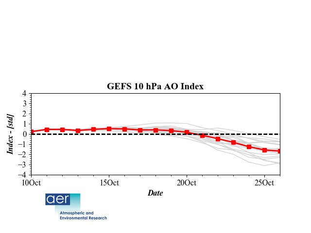
![]() by amugs Wed Oct 11, 2017 10:47 am
by amugs Wed Oct 11, 2017 10:47 am

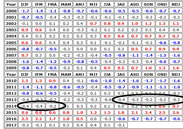
We are starting to see teh first signs of a strat warming event for wave 1 starting to shape up to perturb our PV by about months end

Coincides with this chart for the AO as well
SUN
Spotless Days
Current Stretch: 2 days
2017 total: 58 days (21%)
comparison
2010 total: 51 days (14%)
This Coronal Hole is facing Earth and may bring some effects to teh Northern Lattitudes tomorrow

_________________
Mugs
AKA:King: Snow Weenie
Self Proclaimed
WINTER 2014-15 : 55.12" +.02 for 6 coatings (avg. 35")
WINTER 2015-16 Total - 29.8" (Avg 35")
WINTER 2016-17 : 39.5" so far
amugs- Advanced Forecaster - Mod
- Posts : 15095
Reputation : 213
Join date : 2013-01-07
Age : 54
Location : Hillsdale,NJ
Re: Long Range Thread 15.0
![]() by amugs Fri Oct 20, 2017 11:35 pm
by amugs Fri Oct 20, 2017 11:35 pm

_________________
Mugs
AKA:King: Snow Weenie
Self Proclaimed
WINTER 2014-15 : 55.12" +.02 for 6 coatings (avg. 35")
WINTER 2015-16 Total - 29.8" (Avg 35")
WINTER 2016-17 : 39.5" so far
amugs- Advanced Forecaster - Mod
- Posts : 15095
Reputation : 213
Join date : 2013-01-07
Age : 54
Location : Hillsdale,NJ
Re: Long Range Thread 15.0
![]() by algae888 Sat Oct 21, 2017 9:12 am
by algae888 Sat Oct 21, 2017 9:12 am
Yes mugs and looks to have staying power. Check out the EPO and where it's headed very negative with the recurving typhoon influence. November looks to start cold. pattern change on the way peepsamugs wrote:This is a good look of red over Western Gland region with a nice PNA !!
Last edited by algae888 on Sat Oct 21, 2017 9:14 am; edited 1 time in total
algae888- Advanced Forecaster
- Posts : 5311
Reputation : 46
Join date : 2013-02-05
Age : 62
Location : mt. vernon, new york
Re: Long Range Thread 15.0
![]() by algae888 Sat Oct 21, 2017 9:13 am
by algae888 Sat Oct 21, 2017 9:13 am
algae888- Advanced Forecaster
- Posts : 5311
Reputation : 46
Join date : 2013-02-05
Age : 62
Location : mt. vernon, new york
Re: Long Range Thread 15.0
![]() by algae888 Sat Oct 21, 2017 9:18 am
by algae888 Sat Oct 21, 2017 9:18 am
algae888- Advanced Forecaster
- Posts : 5311
Reputation : 46
Join date : 2013-02-05
Age : 62
Location : mt. vernon, new york
Re: Long Range Thread 15.0
![]() by algae888 Sat Oct 21, 2017 1:13 pm
by algae888 Sat Oct 21, 2017 1:13 pm
algae888- Advanced Forecaster
- Posts : 5311
Reputation : 46
Join date : 2013-02-05
Age : 62
Location : mt. vernon, new york
Re: Long Range Thread 15.0
![]() by frank 638 Sat Oct 21, 2017 1:31 pm
by frank 638 Sat Oct 21, 2017 1:31 pm
frank 638- Senior Enthusiast
- Posts : 2843
Reputation : 37
Join date : 2016-01-01
Age : 40
Location : bronx ny
Page 2 of 42 • 1, 2, 3 ... 22 ... 42 ![]()
|
|
|