
 Search
Long Range Thread 15.0
Page 3 of 42 •  1, 2, 3, 4 ... 22 ... 42
 ![]()
Re: Long Range Thread 15.0
![]() by algae888 Sat Oct 21, 2017 1:13 pm
by algae888 Sat Oct 21, 2017 1:13 pm
algae888- Advanced Forecaster

- Posts : 5311
Join date : 2013-02-05
Re: Long Range Thread 15.0
![]() by frank 638 Sat Oct 21, 2017 1:31 pm
by frank 638 Sat Oct 21, 2017 1:31 pm
frank 638- Senior Enthusiast

- Posts : 2843
Join date : 2016-01-01
Re: Long Range Thread 15.0
![]() by docstox12 Sat Oct 21, 2017 1:33 pm
by docstox12 Sat Oct 21, 2017 1:33 pm
algae888 wrote:Get ready for some winter weather in about a week to ten days. All major models mighty cold. Could see some white too!!
AL, that fits in nicely with the first flurries time around these parts from Oct 15 on.It's going to be a real shock to get that kind of cold after the summer in October we are having.What a shame for this years Fall colors!

docstox12- Wx Statistician Guru

- Posts : 8530
Reputation : 222
Join date : 2013-01-07
Age : 73
Location : Monroe NY
Re: Long Range Thread 15.0
![]() by sroc4 Sun Oct 22, 2017 10:05 am
by sroc4 Sun Oct 22, 2017 10:05 am
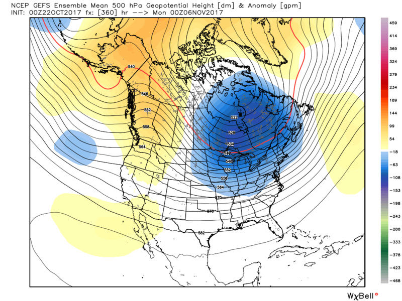
First the MJO: Here is the latest forecast from GFS and Euro: (NOTE: the corrected GFS and Euro MJO has the MJO coming back into the COD)

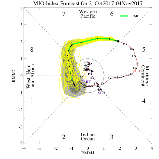
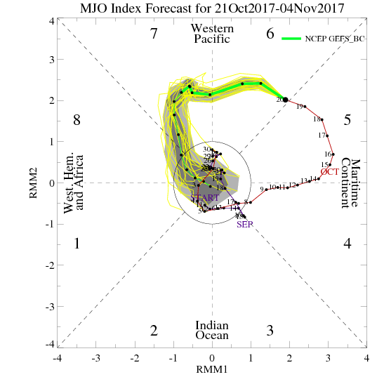
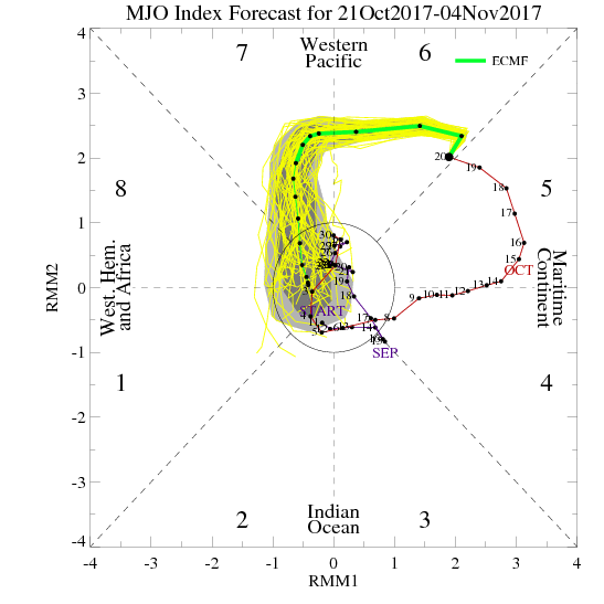
Now lets look at the modeling. Again we have a recurving typhoon and an MJO wave amplification through phases 5-6(which favor cold in the east this time of year) that will amplify the pattern such that by next week we get a nice cold shot. This is agreed upon in both the EPS and GEFS camps.
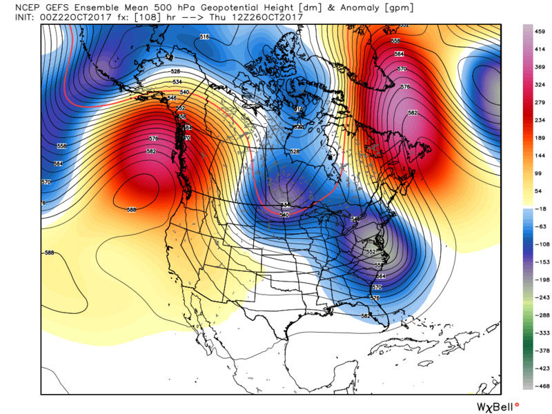
But unfortunately that seems to only lasts a few days before we rebound into the warm sector.
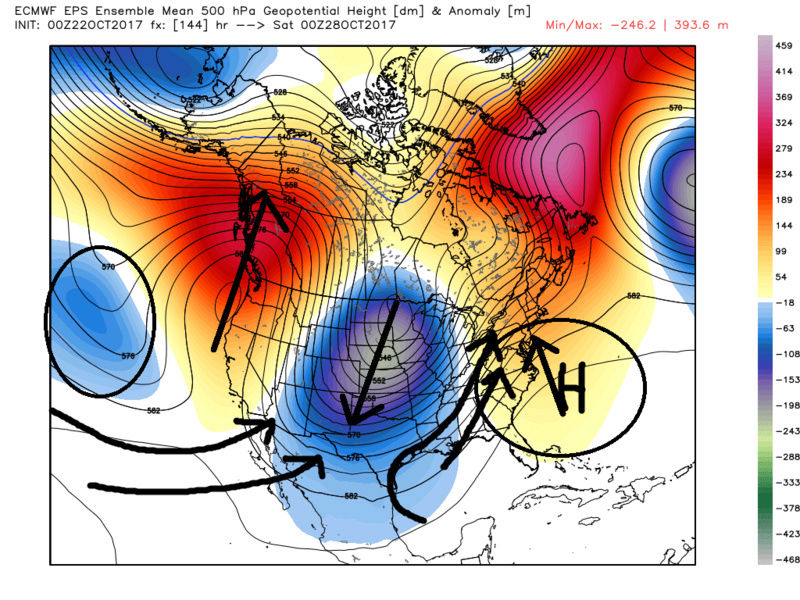
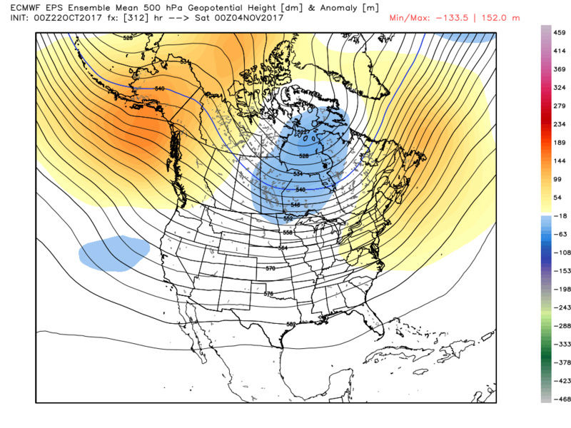
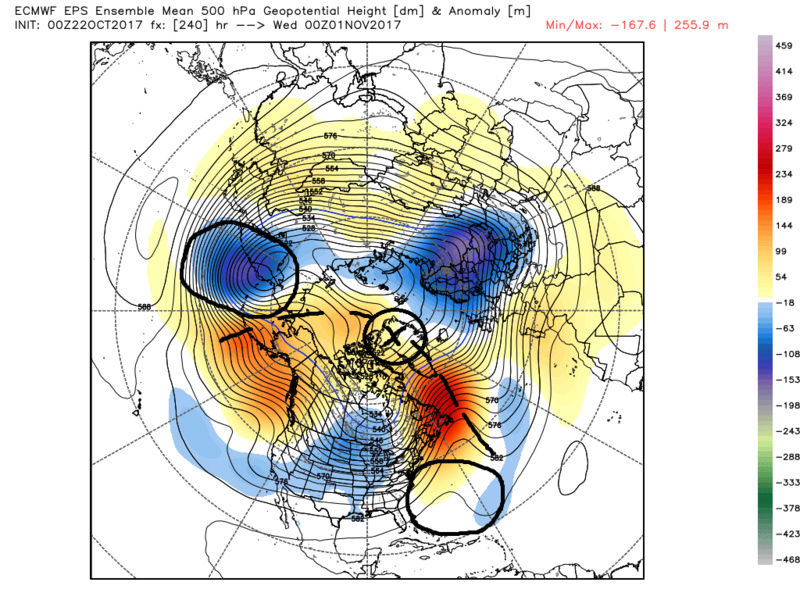
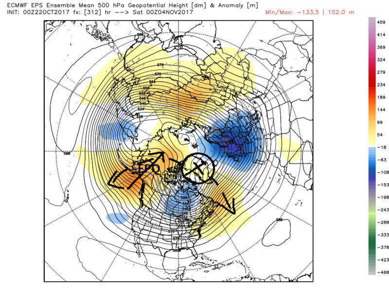
Then the question is to we go back to the cold pattern? Again I would argue that as we get closer in time we cont to see a trend away from below normal anomalies and move more towards the normal to above normal anomalies in the modeling. That trend already has begun esp in the Euro ens. There is a negative anomaly that is consistently showing up off the SW coast. By day ten on the EPS you can see it aids in the enhancement of the STJ and leads to the Mean trough to be further west over the CONUS in a progressive orientation. This in turn enhances the SE ridge such that it puts us into the SW flow aloft. Day 13 and day 15 hint at a similar orientation.
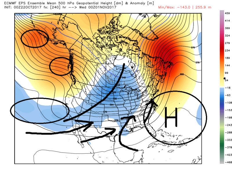
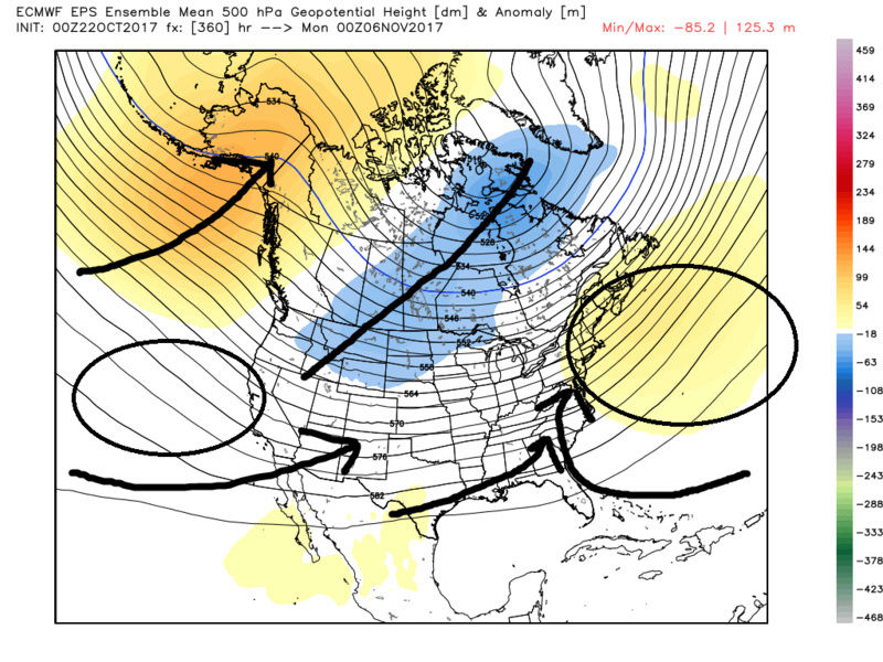
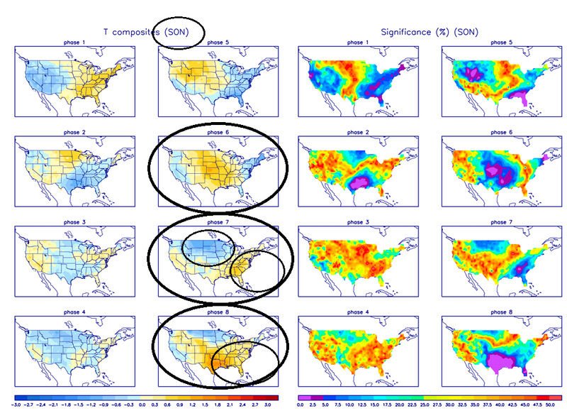
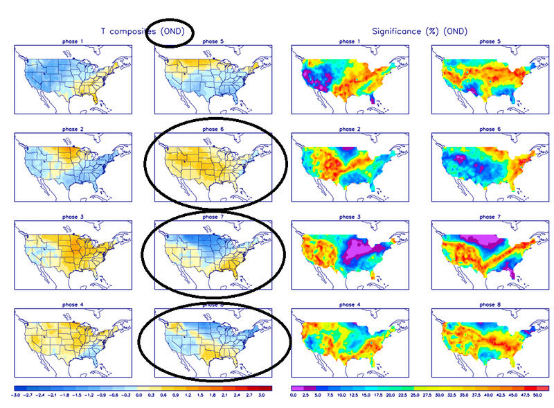
Does this make sense though? Again I argue yes. First off we have the underlying base state that is La Nina like which tends to favor a western trough S Eastern ridge configuration. Look back at the MJO forecasts above. Now see below the MJO temp composites. Below are the differences between the composites for the Sept/Oct/Nov vs the Oct/Nov/Dec period. Both on avg favor the SE ridge over our area in phase 7, but the SON composite also indicates a warm pattern in the east in phase 8 as well. This actually matches up nicely with the look on the Euro ensembles day 10-15 as we end Oct and head into the first week of Nov. The O/N/D composite does seem to favor cooler temp anomalies in the east however in phase 8 suppressing the SE ridge.
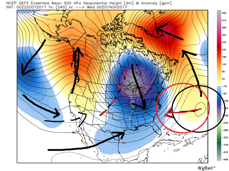
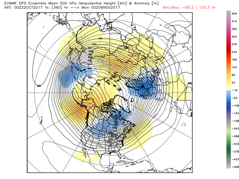
As you can see below the GEFS are a little different in the same time frame regarding the configurations of the Mean trough and ridge. You can see day 10 (hr 240) the SE ridge is centered off the EC in the Atlantic and the mean trough is further east. However reading between the lines I do believe the euro camp may be more correct with its trough ridge orientation in this time frame. I still think given the base state of the atmosphere and the current MJO forecasts sustained cold in the east is not in the cards just yet through the first 1-2 weeks of Nov. Again I REALLY hope I'm wrong but I just don't see it yet. On the bright side as we head deeper into the season the transient cold shots we do get may be complimented by the first flakes to some of our N&W friends.

Last edited by sroc4 on Mon Nov 06, 2017 6:54 am; edited 1 time in total
_________________
"In weather and in life, there's no winning and losing; there's only winning and learning."
WINTER 2012/2013 TOTALS 43.65"WINTER 2017/2018 TOTALS 62.85" WINTER 2022/2023 TOTALS 4.9"
WINTER 2013/2014 TOTALS 64.85"WINTER 2018/2019 TOTALS 14.25" WINTER 2023/2024 TOTALS 13.1"
WINTER 2014/2015 TOTALS 71.20"WINTER 2019/2020 TOTALS 6.35"
WINTER 2015/2016 TOTALS 35.00"WINTER 2020/2021 TOTALS 37.75"
WINTER 2016/2017 TOTALS 42.25"WINTER 2021/2022 TOTALS 31.65"

sroc4- Admin

- Posts : 8354
Reputation : 302
Join date : 2013-01-07
Location : Wading River, LI
Re: Long Range Thread 15.0
![]() by algae888 Sun Oct 22, 2017 11:39 am
by algae888 Sun Oct 22, 2017 11:39 am

algae888- Advanced Forecaster
- Posts : 5311
Reputation : 46
Join date : 2013-02-05
Age : 62
Location : mt. vernon, new york
Re: Long Range Thread 15.0
![]() by sroc4 Sun Oct 22, 2017 1:05 pm
by sroc4 Sun Oct 22, 2017 1:05 pm
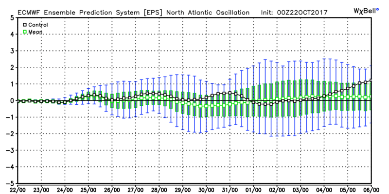
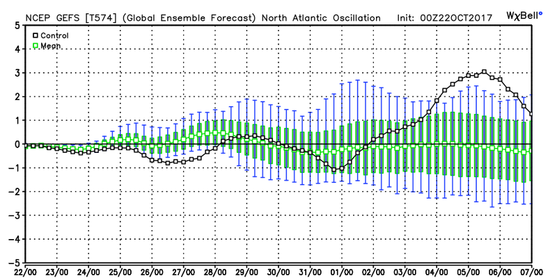
algae888 wrote:Scott only one other thing that you haven't looked at and that is the EPO forecast which is supposed to be very negative late month into November. I also thinks as the wavelengths start lengthening as we head into November the models are having a tough time picking up how far east the cold will come. With the ridging over Alaska and the EPO region and also in the Nao domain I can't help but think that we will be cold here.
-EPO yes, but -NAO. I don't think the look is a true negative NAO(blocking over Greenland vs just anomalous Ridging in the N Atlantic as an extention of the SE/Bermuda ridge. The difference is I'm not seeing the true ridge bridge over the Arctic that forces the cold air south and keeps it there. This time of year I do not believe the -EPO, albeit forecasted strongly neg, is enough. Initially yes because of the amplification of the recurving typhoon, but after that as we head into the 7-15 day time frame this does not look like a -NAO at all. Neutral at best. The ens mean agrees with me. Climatology does not favor a cold/dense enough air mass from the -EPO alone to hit AND hold given the trop Pac influence on the big picture. Without a -NAO the -EPO discharges a cold, but not frigid air mass yet but the underlying influences from the MJO and ENSO status leads to it digging into the central plains but then lifting out over the GL rather than reaching the EC with any staying power. Again transient shots maybe but its a long way off so we shall see. This is simply my interpretation of course and might def be incorrect.
_________________
"In weather and in life, there's no winning and losing; there's only winning and learning."
WINTER 2012/2013 TOTALS 43.65"WINTER 2017/2018 TOTALS 62.85" WINTER 2022/2023 TOTALS 4.9"
WINTER 2013/2014 TOTALS 64.85"WINTER 2018/2019 TOTALS 14.25" WINTER 2023/2024 TOTALS 13.1"
WINTER 2014/2015 TOTALS 71.20"WINTER 2019/2020 TOTALS 6.35"
WINTER 2015/2016 TOTALS 35.00"WINTER 2020/2021 TOTALS 37.75"
WINTER 2016/2017 TOTALS 42.25"WINTER 2021/2022 TOTALS 31.65"
sroc4- Admin
- Posts : 8354
Reputation : 302
Join date : 2013-01-07
Location : Wading River, LI
Re: Long Range Thread 15.0
![]() by rb924119 Sun Oct 22, 2017 1:51 pm
by rb924119 Sun Oct 22, 2017 1:51 pm
rb924119- Meteorologist

- Posts : 6928
Reputation : 194
Join date : 2013-02-06
Age : 32
Location : Greentown, Pa
Re: Long Range Thread 15.0
![]() by algae888 Sun Oct 22, 2017 4:46 pm
by algae888 Sun Oct 22, 2017 4:46 pm


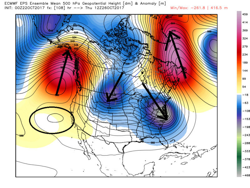
that's a cold look and gefs continue that throughout entire run.


the most encouraging sing to me is the higher heights across the pole. this doesn't look transient to me but locked.

that's a closed UL ridge near the pole. 5 day ave. a true -AO. if we can get the AO to be neg in November I've been reading that there is a very strong likely hood of the AO being neg. DJF. also here is the latest soi which should go neg and start warming the enso up again. we shall see but am getting more encouraged each passing day.

algae888- Advanced Forecaster
- Posts : 5311
Reputation : 46
Join date : 2013-02-05
Age : 62
Location : mt. vernon, new york
Re: Long Range Thread 15.0
![]() by algae888 Sun Oct 22, 2017 5:01 pm
by algae888 Sun Oct 22, 2017 5:01 pm

to this

there is no sign of the Alaskan closed ULL (which is the thing that will kill this winter) on any guidance for next 2 weeks. that's a pattern change a significant one at that. say good bye to the +7 departures that we have seen over the last 6 weeks. good riddance to that! at our latitude we can work with +1or 2 and still do well with snow totals.
algae888- Advanced Forecaster
- Posts : 5311
Reputation : 46
Join date : 2013-02-05
Age : 62
Location : mt. vernon, new york
Re: Long Range Thread 15.0
![]() by Snow88 Sun Oct 22, 2017 7:58 pm
by Snow88 Sun Oct 22, 2017 7:58 pm

Snow88- Senior Enthusiast
- Posts : 2193
Reputation : 4
Join date : 2013-01-09
Age : 35
Location : Brooklyn, NY
Re: Long Range Thread 15.0
![]() by amugs Sun Oct 22, 2017 10:14 pm
by amugs Sun Oct 22, 2017 10:14 pm
Snowpack builds over Canada these next two weeks which will help start the cold flow when winds go to N&NW directions.
GEFS are hinting the look of winter to roll in Nov

_________________
Mugs
AKA:King: Snow Weenie
Self Proclaimed
WINTER 2014-15 : 55.12" +.02 for 6 coatings (avg. 35")
WINTER 2015-16 Total - 29.8" (Avg 35")
WINTER 2016-17 : 39.5" so far

amugs- Advanced Forecaster - Mod

- Posts : 15095
Reputation : 213
Join date : 2013-01-07
Age : 54
Location : Hillsdale,NJ
Re: Long Range Thread 15.0
![]() by algae888 Mon Oct 23, 2017 3:29 am
by algae888 Mon Oct 23, 2017 3:29 am
algae888- Advanced Forecaster
- Posts : 5311
Reputation : 46
Join date : 2013-02-05
Age : 62
Location : mt. vernon, new york
Re: Long Range Thread 15.0
![]() by Snow88 Mon Oct 23, 2017 10:01 am
by Snow88 Mon Oct 23, 2017 10:01 am
Snow88- Senior Enthusiast
- Posts : 2193
Reputation : 4
Join date : 2013-01-09
Age : 35
Location : Brooklyn, NY
Re: Long Range Thread 15.0
![]() by Frank_Wx Mon Oct 23, 2017 3:28 pm
by Frank_Wx Mon Oct 23, 2017 3:28 pm
_________________
_______________________________________________________________________________________________________
CLICK HERE to view NJ Strong Snowstorm Classifications

Frank_Wx- Godzilla Seeker
- Posts : 21305
Reputation : 328
Join date : 2013-01-05
Age : 32
Location : Jersey City, NJ -

Re: Long Range Thread 15.0
![]() by Math23x7 Mon Oct 23, 2017 5:09 pm
by Math23x7 Mon Oct 23, 2017 5:09 pm
Frank_Wx wrote:Looks like we're heading into a pattern change. The GEFS and EPS are in agreement that we're headed toward a temp regime of normal to below normal temps around Halloween through the first week of November. The MJO is very active as Scott alluded to in a post yesterday. This type of tropical forcing will promote troughing over the eastern U.S. The question will be how long does the cold last? I am thinking it's a transient 7-10 period at the moment of normal to below temps then temps will rebound. This time of years it's pretty typical to go into transient patterns as the overall winter weather pattern begins to form.
Keep in mind that just because we have an extended cold stretch late-October to early November, it does not mean necessarily that is sustained.
Here is the 11 day stretch from October 27th to November 6th in 2011:
Date High Low Anomaly
10/27 61 38 -4
10/28 49 36 -10.5
10/29 45 33 -14 (day of snowstorm)
10/30 46 33 -13
10/31 53 37 -7.5
11/01 55 45 -2.5
11/02 57 42 -2
11/03 59 46 +1
11/04 53 41 -4.5
11/05 49 36 -8
11/06 54 38 -4.5
10 of those 11 days were below normal and it was 6.3 degrees below average during that stretch. Then, as I mentioned a while back, in the 167-day stretch from November 7th, 2011 to April 21st, 2012, there were only 25 days with below normal temperatures.
Until a sustained super negative NAO/AO couplet shows up, I'm not gonna get too excited for the winter.
Math23x7- Wx Statistician Guru
- Posts : 2379
Reputation : 68
Join date : 2013-01-08
Re: Long Range Thread 15.0
![]() by amugs Mon Oct 23, 2017 8:49 pm
by amugs Mon Oct 23, 2017 8:49 pm

_________________
Mugs
AKA:King: Snow Weenie
Self Proclaimed
WINTER 2014-15 : 55.12" +.02 for 6 coatings (avg. 35")
WINTER 2015-16 Total - 29.8" (Avg 35")
WINTER 2016-17 : 39.5" so far
amugs- Advanced Forecaster - Mod
- Posts : 15095
Reputation : 213
Join date : 2013-01-07
Age : 54
Location : Hillsdale,NJ
Re: Long Range Thread 15.0
![]() by amugs Tue Oct 24, 2017 11:27 am
by amugs Tue Oct 24, 2017 11:27 am
Cold air will dump into Canada and Central plains and bleed east for early November
_________________
Mugs
AKA:King: Snow Weenie
Self Proclaimed
WINTER 2014-15 : 55.12" +.02 for 6 coatings (avg. 35")
WINTER 2015-16 Total - 29.8" (Avg 35")
WINTER 2016-17 : 39.5" so far
amugs- Advanced Forecaster - Mod
- Posts : 15095
Reputation : 213
Join date : 2013-01-07
Age : 54
Location : Hillsdale,NJ
Re: Long Range Thread 15.0
![]() by sroc4 Tue Oct 24, 2017 1:19 pm
by sroc4 Tue Oct 24, 2017 1:19 pm
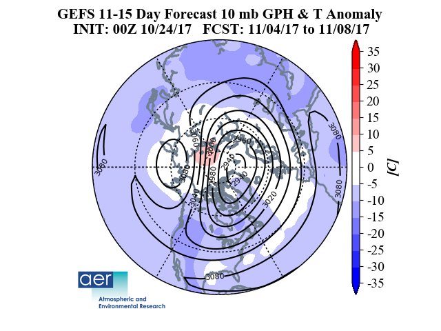
amugs wrote:Cohen saying nue NOrth South elongation of Polar Vortex.
Cold air will dump into Canada and Central plains and bleed east for early November
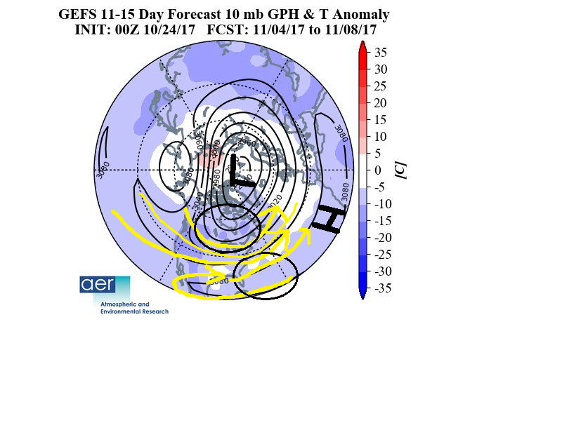
Unfort Im not so sure that look really benefits us unless the center of the PV shifts further south from where it is. Plus that is the 10mb map. What does 30mb 50mb and 70mb look like. That configuration does not translate 1:1 per se. In addition that is a long way off and the LR Strat forecasts are just as subject to change as the 500mb heights are as well. That said even if that where to come true the orientation is such that we still get a western and SW zonal flow over much of the CONUS. The coldest air will be felt in the N Plains and central Canada like you mentioned but the SE ridge would likely flex with this look verbatim.
Unfort the more I look at the LR ensemble forecasts the more confident I am becoming at the return to above normal after the start of the new month. Write up to follow sometime in the next day or so.
_________________
"In weather and in life, there's no winning and losing; there's only winning and learning."
WINTER 2012/2013 TOTALS 43.65"WINTER 2017/2018 TOTALS 62.85" WINTER 2022/2023 TOTALS 4.9"
WINTER 2013/2014 TOTALS 64.85"WINTER 2018/2019 TOTALS 14.25" WINTER 2023/2024 TOTALS 13.1"
WINTER 2014/2015 TOTALS 71.20"WINTER 2019/2020 TOTALS 6.35"
WINTER 2015/2016 TOTALS 35.00"WINTER 2020/2021 TOTALS 37.75"
WINTER 2016/2017 TOTALS 42.25"WINTER 2021/2022 TOTALS 31.65"
sroc4- Admin
- Posts : 8354
Reputation : 302
Join date : 2013-01-07
Location : Wading River, LI
Re: Long Range Thread 15.0
![]() by amugs Tue Oct 24, 2017 3:01 pm
by amugs Tue Oct 24, 2017 3:01 pm
Mike that would not work - it would suppress everything on us to North Carolina. We need a moderate N NAO and AO to do the job IMO. A SN EPO would be tremendous as it was in 2014-15 for us. No red blob for sure there but if the warmer waters from the leftover Super Nino keep moving NE then the PDO maybe able to help in that dept.
From JD site with current SST's
QBO East vs West diagrams and resulting air masses
.png)
_________________
Mugs
AKA:King: Snow Weenie
Self Proclaimed
WINTER 2014-15 : 55.12" +.02 for 6 coatings (avg. 35")
WINTER 2015-16 Total - 29.8" (Avg 35")
WINTER 2016-17 : 39.5" so far
amugs- Advanced Forecaster - Mod
- Posts : 15095
Reputation : 213
Join date : 2013-01-07
Age : 54
Location : Hillsdale,NJ
Re: Long Range Thread 15.0
![]() by amugs Tue Oct 24, 2017 3:06 pm
by amugs Tue Oct 24, 2017 3:06 pm
EPS
EURO goes insanely N - if this were J-F winter we'd be sneezing icicles!!

_________________
Mugs
AKA:King: Snow Weenie
Self Proclaimed
WINTER 2014-15 : 55.12" +.02 for 6 coatings (avg. 35")
WINTER 2015-16 Total - 29.8" (Avg 35")
WINTER 2016-17 : 39.5" so far
amugs- Advanced Forecaster - Mod
- Posts : 15095
Reputation : 213
Join date : 2013-01-07
Age : 54
Location : Hillsdale,NJ
Re: Long Range Thread 15.0
![]() by algae888 Tue Oct 24, 2017 4:40 pm
by algae888 Tue Oct 24, 2017 4:40 pm


algae888- Advanced Forecaster
- Posts : 5311
Reputation : 46
Join date : 2013-02-05
Age : 62
Location : mt. vernon, new york
Re: Long Range Thread 15.0
![]() by algae888 Tue Oct 24, 2017 4:45 pm
by algae888 Tue Oct 24, 2017 4:45 pm
algae888- Advanced Forecaster
- Posts : 5311
Reputation : 46
Join date : 2013-02-05
Age : 62
Location : mt. vernon, new york
Re: Long Range Thread 15.0
![]() by amugs Tue Oct 24, 2017 4:46 pm
by amugs Tue Oct 24, 2017 4:46 pm
Look at what the Ukie serve up for the anniversary of Indore say Sandra??

_________________
Mugs
AKA:King: Snow Weenie
Self Proclaimed
WINTER 2014-15 : 55.12" +.02 for 6 coatings (avg. 35")
WINTER 2015-16 Total - 29.8" (Avg 35")
WINTER 2016-17 : 39.5" so far
amugs- Advanced Forecaster - Mod
- Posts : 15095
Reputation : 213
Join date : 2013-01-07
Age : 54
Location : Hillsdale,NJ
Re: Long Range Thread 15.0
![]() by jmanley32 Tue Oct 24, 2017 9:16 pm
by jmanley32 Tue Oct 24, 2017 9:16 pm
Lets hope this does not start to look worse in a few days, we def do not need a destructive storm, a good wind and rain (or snow but for god sakes its 70 not go count on that) weould be fine by me.amugs wrote:AL cocnur. Recurving typhoon helpING us out.
Look at what the Ukie serve up for the anniversary of Indore say Sandra??

jmanley32- Senior Enthusiast
- Posts : 20535
Reputation : 108
Join date : 2013-12-12
Age : 43
Location : Yonkers, NY
Re: Long Range Thread 15.0
![]() by amugs Thu Oct 26, 2017 10:17 am
by amugs Thu Oct 26, 2017 10:17 am


This will bring heat flux up to the poleward region wakening the PV
_________________
Mugs
AKA:King: Snow Weenie
Self Proclaimed
WINTER 2014-15 : 55.12" +.02 for 6 coatings (avg. 35")
WINTER 2015-16 Total - 29.8" (Avg 35")
WINTER 2016-17 : 39.5" so far
amugs- Advanced Forecaster - Mod
- Posts : 15095
Reputation : 213
Join date : 2013-01-07
Age : 54
Location : Hillsdale,NJ
Re: Long Range Thread 15.0
![]() by algae888 Thu Oct 26, 2017 4:05 pm
by algae888 Thu Oct 26, 2017 4:05 pm


algae888- Advanced Forecaster
- Posts : 5311
Reputation : 46
Join date : 2013-02-05
Age : 62
Location : mt. vernon, new york
Re: Long Range Thread 15.0
![]() by Frank_Wx Wed Nov 01, 2017 9:04 pm
by Frank_Wx Wed Nov 01, 2017 9:04 pm

Also, I will not be issuing a Winter Outlook this year. Time does not allow it. Extensive research has to go into these outlooks to gather all the facts. I will leave it to the pro's to handle.
_________________
_______________________________________________________________________________________________________
CLICK HERE to view NJ Strong Snowstorm Classifications
Frank_Wx- Godzilla Seeker
- Posts : 21305
Reputation : 328
Join date : 2013-01-05
Age : 32
Location : Jersey City, NJ -
Page 3 of 42 • 1, 2, 3, 4 ... 22 ... 42 ![]()
|
|
|