
 Search
Long Range Thread 15.0
Page 4 of 42 •  1, 2, 3, 4, 5 ... 23 ... 42
 ![]()
Re: Long Range Thread 15.0
![]() by algae888 Thu Oct 26, 2017 4:05 pm
by algae888 Thu Oct 26, 2017 4:05 pm


algae888- Advanced Forecaster

- Posts : 5311
Join date : 2013-02-05
Re: Long Range Thread 15.0
![]() by Frank_Wx Wed Nov 01, 2017 9:04 pm
by Frank_Wx Wed Nov 01, 2017 9:04 pm

Also, I will not be issuing a Winter Outlook this year. Time does not allow it. Extensive research has to go into these outlooks to gather all the facts. I will leave it to the pro's to handle.
Frank_Wx- Godzilla Seeker

- Posts : 21308
Join date : 2013-01-05 -

Math23x7- Wx Statistician Guru

- Posts : 2382
Reputation : 68
Join date : 2013-01-08
Re: Long Range Thread 15.0
![]() by Radz Thu Nov 02, 2017 6:18 am
by Radz Thu Nov 02, 2017 6:18 am
Math23x7 wrote:Any contest thread this year?
Don't think we ever found out who won last year

Radz- Pro Enthusiast

- Posts : 1028
Reputation : 17
Join date : 2013-01-12
Location : Cortlandt Manor NY
Re: Long Range Thread 15.0
![]() by sroc4 Thu Nov 02, 2017 8:34 am
by sroc4 Thu Nov 02, 2017 8:34 am


_________________
"In weather and in life, there's no winning and losing; there's only winning and learning."
WINTER 2012/2013 TOTALS 43.65"WINTER 2017/2018 TOTALS 62.85" WINTER 2022/2023 TOTALS 4.9"
WINTER 2013/2014 TOTALS 64.85"WINTER 2018/2019 TOTALS 14.25" WINTER 2023/2024 TOTALS 13.1"
WINTER 2014/2015 TOTALS 71.20"WINTER 2019/2020 TOTALS 6.35"
WINTER 2015/2016 TOTALS 35.00"WINTER 2020/2021 TOTALS 37.75"
WINTER 2016/2017 TOTALS 42.25"WINTER 2021/2022 TOTALS 31.65"

sroc4- Admin
- Posts : 8441
Reputation : 302
Join date : 2013-01-07
Location : Wading River, LI
Re: Long Range Thread 15.0
![]() by sroc4 Thu Nov 02, 2017 9:36 am
by sroc4 Thu Nov 02, 2017 9:36 am

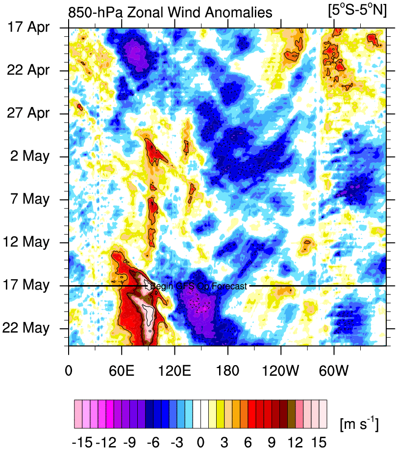
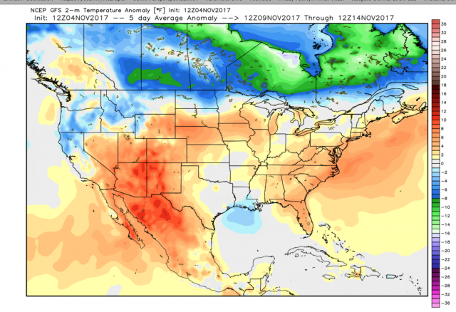
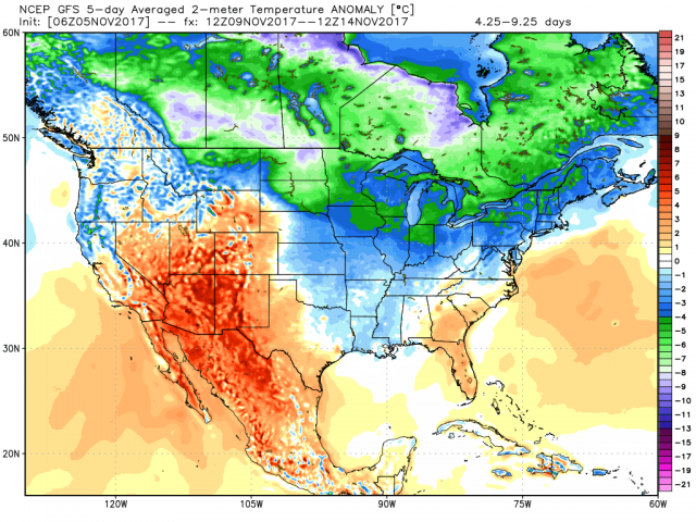
Don't believe me. Think back to last winter Feb 2017. -EPO, -WPO, +AO, +NAO with weak La Nina base state with a persistent trough off the west coast that interacted with the Canadian trough. Result? A mean 500MB pattern that looked like this:

My point here is be really careful how much stock we put into any significant cold this month. I expect a few transient shots but when all is said and done expect a warm month overall. IF the MJO does in fact get into phase 2 then a decent cold shot is def possible. The past 7days the GFS has actually been better at handling the MJO outcome so the cool shot coming in a week or so may be real.
_________________
"In weather and in life, there's no winning and losing; there's only winning and learning."
WINTER 2012/2013 TOTALS 43.65"WINTER 2017/2018 TOTALS 62.85" WINTER 2022/2023 TOTALS 4.9"
WINTER 2013/2014 TOTALS 64.85"WINTER 2018/2019 TOTALS 14.25" WINTER 2023/2024 TOTALS 13.1"
WINTER 2014/2015 TOTALS 71.20"WINTER 2019/2020 TOTALS 6.35"
WINTER 2015/2016 TOTALS 35.00"WINTER 2020/2021 TOTALS 37.75"
WINTER 2016/2017 TOTALS 42.25"WINTER 2021/2022 TOTALS 31.65"
sroc4- Admin
- Posts : 8441
Reputation : 302
Join date : 2013-01-07
Location : Wading River, LI
Re: Long Range Thread 15.0
![]() by Guest Thu Nov 02, 2017 7:36 pm
by Guest Thu Nov 02, 2017 7:36 pm
Guest- Guest
Re: Long Range Thread 15.0
![]() by frank 638 Fri Nov 03, 2017 4:35 pm
by frank 638 Fri Nov 03, 2017 4:35 pm
frank 638- Senior Enthusiast

- Posts : 2861
Reputation : 37
Join date : 2016-01-01
Age : 41
Location : bronx ny
Re: Long Range Thread 15.0
![]() by frank 638 Fri Nov 03, 2017 4:54 pm
by frank 638 Fri Nov 03, 2017 4:54 pm
frank 638- Senior Enthusiast
- Posts : 2861
Reputation : 37
Join date : 2016-01-01
Age : 41
Location : bronx ny
Re: Long Range Thread 15.0
![]() by amugs Fri Nov 03, 2017 11:20 pm
by amugs Fri Nov 03, 2017 11:20 pm

_________________
Mugs
AKA:King: Snow Weenie
Self Proclaimed
WINTER 2014-15 : 55.12" +.02 for 6 coatings (avg. 35")
WINTER 2015-16 Total - 29.8" (Avg 35")
WINTER 2016-17 : 39.5" so far

amugs- Advanced Forecaster - Mod

- Posts : 15130
Reputation : 213
Join date : 2013-01-07
Age : 54
Location : Hillsdale,NJ
Re: Long Range Thread 15.0
![]() by Math23x7 Fri Nov 03, 2017 11:55 pm
by Math23x7 Fri Nov 03, 2017 11:55 pm
amugs wrote:Gfs temp next Fri night wowza freezer
Keep in mind that the GFS OP has a tendency to overdo cold air in the mid-long range.
Math23x7- Wx Statistician Guru
- Posts : 2382
Reputation : 68
Join date : 2013-01-08
Re: Long Range Thread 15.0
![]() by algae888 Sat Nov 04, 2017 5:42 am
by algae888 Sat Nov 04, 2017 5:42 am
Yes mugs are first arctic front of the season. Nws disco...amugs wrote:Gfs temp next Fri night wowza freezer
There is still the notion that Pacific energy aloft should bring clouds and at least a slight chance of rain Tue afternoon into Tue night, and went with a GFS/ECMWF compromise during this time frame. If there is precipitation Tuesday night, there could even be some mixing in of snow well inland as a colder air mass will be building in. The high builds in for the middle of the week. It is now looking more likely that a freeze will occur for much of the area Thursday night. Temperatures have been lowered in the forecast. The next system then looks to be an arctic frontal passage, and as a result, forecast high temperatures have been lowered significantly from guidance on Friday, with lows in the 20s and 30s Thu night, and highs only in the 40s on Fri. There could be some flurries with the passage of the front.

algae888- Advanced Forecaster
- Posts : 5311
Reputation : 46
Join date : 2013-02-05
Age : 62
Location : mt. vernon, new york
Re: Long Range Thread 15.0
![]() by algae888 Sat Nov 04, 2017 5:47 am
by algae888 Sat Nov 04, 2017 5:47 am
algae888- Advanced Forecaster
- Posts : 5311
Reputation : 46
Join date : 2013-02-05
Age : 62
Location : mt. vernon, new york
Re: Long Range Thread 15.0
![]() by algae888 Sat Nov 04, 2017 5:52 am
by algae888 Sat Nov 04, 2017 5:52 am
algae888- Advanced Forecaster
- Posts : 5311
Reputation : 46
Join date : 2013-02-05
Age : 62
Location : mt. vernon, new york
Re: Long Range Thread 15.0
![]() by amugs Sat Nov 04, 2017 8:10 am
by amugs Sat Nov 04, 2017 8:10 am
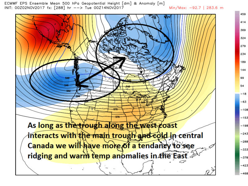
Mike yes BUT look at the synoptic 's of the pattern and so if it is 4*F to cold it is still a frigging cold look after what we have been through temp wise. Wil the SE Ridge buold back after is a question or shall it be beaten back or pushed more east. The trough on the west coast retrograde's future west which argues for a trough on the east coast allowing a N to slightly POS PNA Ridge to formMath23x7 wrote:amugs wrote:Gfs temp next Fri night wowza freezer
Keep in mind that the GFS OP has a tendency to overdo cold air in the mid-long range.
_________________
Mugs
AKA:King: Snow Weenie
Self Proclaimed
WINTER 2014-15 : 55.12" +.02 for 6 coatings (avg. 35")
WINTER 2015-16 Total - 29.8" (Avg 35")
WINTER 2016-17 : 39.5" so far
amugs- Advanced Forecaster - Mod
- Posts : 15130
Reputation : 213
Join date : 2013-01-07
Age : 54
Location : Hillsdale,NJ
Re: Long Range Thread 15.0
![]() by amugs Sat Nov 04, 2017 8:20 am
by amugs Sat Nov 04, 2017 8:20 am
And the GEFS showing we may go after recoed lows latter part of the week for Friday and Saturday in some area maybe even NYC, MAYBE!!

_________________
Mugs
AKA:King: Snow Weenie
Self Proclaimed
WINTER 2014-15 : 55.12" +.02 for 6 coatings (avg. 35")
WINTER 2015-16 Total - 29.8" (Avg 35")
WINTER 2016-17 : 39.5" so far
amugs- Advanced Forecaster - Mod
- Posts : 15130
Reputation : 213
Join date : 2013-01-07
Age : 54
Location : Hillsdale,NJ
Re: Long Range Thread 15.0
![]() by frank 638 Sat Nov 04, 2017 9:40 am
by frank 638 Sat Nov 04, 2017 9:40 am
frank 638- Senior Enthusiast
- Posts : 2861
Reputation : 37
Join date : 2016-01-01
Age : 41
Location : bronx ny
Re: Long Range Thread 15.0
![]() by aiannone Sat Nov 04, 2017 1:10 pm
by aiannone Sat Nov 04, 2017 1:10 pm
_________________
-Alex Iannone-

aiannone- Senior Enthusiast - Mod
- Posts : 4822
Reputation : 92
Join date : 2013-01-07
Location : Saint James, LI (Northwest Suffolk Co.)

algae888- Advanced Forecaster
- Posts : 5311
Reputation : 46
Join date : 2013-02-05
Age : 62
Location : mt. vernon, new york
Re: Long Range Thread 15.0
![]() by algae888 Sun Nov 05, 2017 6:26 am
by algae888 Sun Nov 05, 2017 6:26 am

Wednesday 12z

to this. for december
algae888- Advanced Forecaster
- Posts : 5311
Reputation : 46
Join date : 2013-02-05
Age : 62
Location : mt. vernon, new york
Re: Long Range Thread 15.0
![]() by algae888 Sun Nov 05, 2017 6:59 am
by algae888 Sun Nov 05, 2017 6:59 am


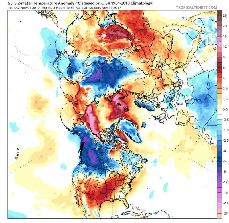
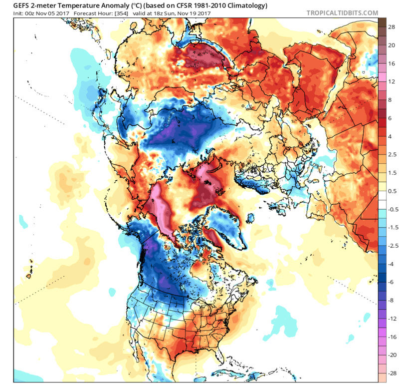
top image we do not want. look at all the blue over the pole and GL. that is where we were/are. bottom image has a -EPO, -AO, -NAO. this is what we want asp as we head towards dec. even though it looks warm on bottom panel for us , a look like that on jan 1st would be much different in our neck of the woods. this switch has been on guidance now for several days. let's see if this holds. i'll keep saying this, I love the -EPO/WPO ridge that has been a consistent feature for days now and looks to continue throughout ensembles (16 days). no let up I n sight.


strong signal there with smoothing on ensemble guidance.
algae888- Advanced Forecaster
- Posts : 5311
Reputation : 46
Join date : 2013-02-05
Age : 62
Location : mt. vernon, new york
Re: Long Range Thread 15.0
![]() by Radz Sun Nov 05, 2017 7:49 am
by Radz Sun Nov 05, 2017 7:49 am
Radz- Pro Enthusiast
- Posts : 1028
Reputation : 17
Join date : 2013-01-12
Location : Cortlandt Manor NY
Re: Long Range Thread 15.0
![]() by amugs Sun Nov 05, 2017 10:01 am
by amugs Sun Nov 05, 2017 10:01 am

A HUGGEEE HP over Siberia always argues for a trough over the east and a N AO - look at that over the pole - give me this sin JAN and we are 0 or below peeps!!

_________________
Mugs
AKA:King: Snow Weenie
Self Proclaimed
WINTER 2014-15 : 55.12" +.02 for 6 coatings (avg. 35")
WINTER 2015-16 Total - 29.8" (Avg 35")
WINTER 2016-17 : 39.5" so far
amugs- Advanced Forecaster - Mod
- Posts : 15130
Reputation : 213
Join date : 2013-01-07
Age : 54
Location : Hillsdale,NJ
Re: Long Range Thread 15.0
![]() by sroc4 Sun Nov 05, 2017 11:42 am
by sroc4 Sun Nov 05, 2017 11:42 am
algae888 wrote:this is what we are looking to see. I could care less about sensible weather on nov. 5th(although I will always welcome snow)
top image we do not want. look at all the blue over the pole and GL. that is where we were/are. bottom image has a -EPO, -AO, -NAO. this is what we want asp as we head towards dec. even though it looks warm on bottom panel for us , a look like that on jan 1st would be much different in our neck of the woods. this switch has been on guidance now for several days. let's see if this holds.
Al be careful. The maps your using above are the Mean Surface Low Pressure Anomalies and not the 500mb Anomalies. The bottom image you show above would be warm in January or at any time of year for the east with a dominant HP in that position. This would put us in a deep SW flow at the surface and when you look at the upperlevels you will see that is a deep SW flow aloft as well. We want that HP centered N of the great lakes and not off the SE coast. If we look at the concurrent 500mb maps for the image you posted above you will see we have the -WPO and maybe weakly negative EPO but the AO is positive and the NAO is likely either neutral at best but probably positive as well as the ensemble spread is likely leading to the positive looking heights over Greenland. The PNA region is also negative for the image you have above which as you can see promotes the SE ridge in the east and SW flow aloft and at the surface in the east.
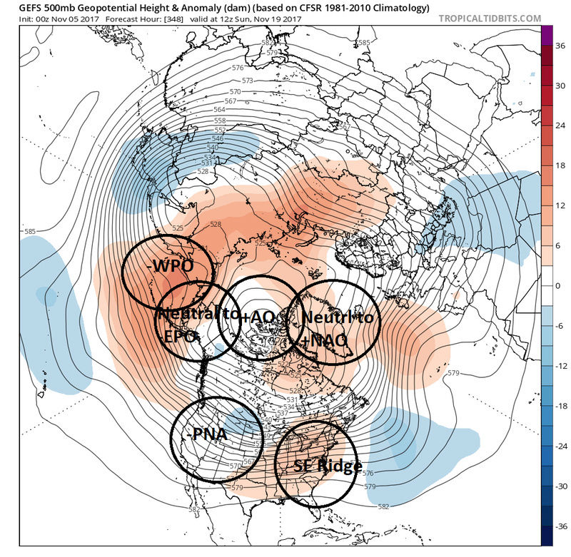

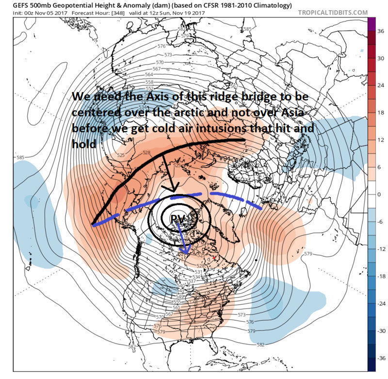
Below is an example of what we want to start seeing if we are to get the cold air to infiltrate with any real staying power. The -PNA has been and will continue to be a thorn in our side this month and likely into early Dec. Again a favorable MJO impulse can influence the mean pattern such that a transient pull back of the western trough could allow a ridge to go up in the PNA region. With the -WPO and -EPO locked in for the time being as Al points out if there is any ridging in the west the cold air spills east even with a +NAO and +AO. We will likely see this happen heading into next weekend. Like has been said by Al and Mugs(also Al), Al squared) Canada is building cold and snow so when we get the cold to come it should be cold! What I will say is there is a chance that the ridge bridge being showed in the image below at the 500mb level would likely promote HP dominating over Siberia. This might give us a really good chance at a true wave 1 or wave 2 attack on our strat. and increased chances at a SSWE headed into early part of Dec. I'm still confident that Nov will likely end the month normal 2-5+ above normal T, but we will see. Remember if you see an amplified MJO forecast ask yourself does the LR model forecast agree or disagree with it. If the MJO forecast remains consistently amplified in the colder phases expect the models to correct to that. If the MJOP looks to go into warm phases expect the models to correct to that. And if we get a SSWE once again expect model mayhem until we get closer.
_________________
"In weather and in life, there's no winning and losing; there's only winning and learning."
WINTER 2012/2013 TOTALS 43.65"WINTER 2017/2018 TOTALS 62.85" WINTER 2022/2023 TOTALS 4.9"
WINTER 2013/2014 TOTALS 64.85"WINTER 2018/2019 TOTALS 14.25" WINTER 2023/2024 TOTALS 13.1"
WINTER 2014/2015 TOTALS 71.20"WINTER 2019/2020 TOTALS 6.35"
WINTER 2015/2016 TOTALS 35.00"WINTER 2020/2021 TOTALS 37.75"
WINTER 2016/2017 TOTALS 42.25"WINTER 2021/2022 TOTALS 31.65"
sroc4- Admin
- Posts : 8441
Reputation : 302
Join date : 2013-01-07
Location : Wading River, LI
Re: Long Range Thread 15.0
![]() by algae888 Sun Nov 05, 2017 12:27 pm
by algae888 Sun Nov 05, 2017 12:27 pm
algae888- Advanced Forecaster
- Posts : 5311
Reputation : 46
Join date : 2013-02-05
Age : 62
Location : mt. vernon, new york
Re: Long Range Thread 15.0
![]() by algae888 Sun Nov 05, 2017 12:32 pm
by algae888 Sun Nov 05, 2017 12:32 pm
algae888- Advanced Forecaster
- Posts : 5311
Reputation : 46
Join date : 2013-02-05
Age : 62
Location : mt. vernon, new york
Re: Long Range Thread 15.0
![]() by amugs Sun Nov 05, 2017 1:17 pm
by amugs Sun Nov 05, 2017 1:17 pm
to this
In the image you show above that is a N WPO and a Neutral EPO
with a Neutral PNA and a slight - NAO albeit weak but there so it may be fighting itself here.
So as you point out changes in models will be the rule and norm
If we go into the MJO pahses as per GEFS - we are warm, if we go via EURO we are about normal
Good news on the solar front as well
Spotless Days
Current Stretch: 4 days
2017 total: 72 days (23%)
2016 total: 32 days (9%)
2015 total: 0 days (0%)
2014 total: 1 day (<1%)
2013 total: 0 days (0%)
2012 total: 0 days (0%)
2011 total: 2 days (<1%)
2010 total: 51 days (14%)
2009 total: 260 days (71%)
Warmth fighting cold in Trop PAC
EAST BASED NINA
_________________
Mugs
AKA:King: Snow Weenie
Self Proclaimed
WINTER 2014-15 : 55.12" +.02 for 6 coatings (avg. 35")
WINTER 2015-16 Total - 29.8" (Avg 35")
WINTER 2016-17 : 39.5" so far
amugs- Advanced Forecaster - Mod
- Posts : 15130
Reputation : 213
Join date : 2013-01-07
Age : 54
Location : Hillsdale,NJ
Page 4 of 42 • 1, 2, 3, 4, 5 ... 23 ... 42 ![]()
|
|
|