
 Search
December 9th Storm - Snow Map
Page 1 of 13 • 1, 2, 3 ... 11, 12, 13 ![]()

December 9th Storm - Snow Map
![]() by Frank_Wx Fri Dec 08, 2017 9:31 am
by Frank_Wx Fri Dec 08, 2017 9:31 am
We have been mentioning December 6th pattern change for some time now, and even called out December 9th as a date that may feature our first snowstorm. Alas, here we are and our first winter storm of the season is upon us.

What was originally looking like a glancing blow with little snow totals has changed drastically in the last 24 hours to a significant storm event for many. My original thinking was this would be a minor event because of the transient blocking in the NAO region and lack of HP or 50/50 Low to our north. However, things changed when models began showing a partial phase between the northern and southern branches of energy in response to the very positive PNA (western ridge) - which you can clearly see on this graph.


On the 500mb vorticity map valid for 1pm and 7pm Saturday, check out that piece of energy digging into the Midwest and toward the east coast. This energy was not always there on the models. But because of the extensive and strong western ridge, this piece of northern energy has no choice but to dig into the U.S. and try to phase with the southern energy. They never fully phase, but this northern energy is so strong is raises heights along the east coast which allows the low pressure that develops from the southern energy to track closer to the coast.

The low pressure takes a track to the 40/70 benchmark. The precipitation field is expansive in response to the partial phasing that is happening between each pieces of upper energy. It may not be a storm with the greatest frontogenesis, or lift, (mechanism that brings thick snow flakes, rates, and high snow totals), but it will be a moderate event for many.
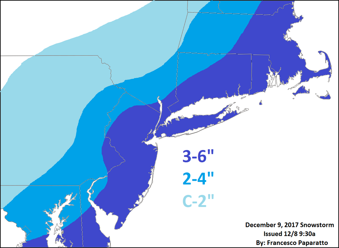
Here is my snow map for this event. I am being mindful of dry air and a relatively quick moving system due to lack of blocking. Also, do not rule out mixing with rain along the Jersey Shore and southern/eastern parts of Long Island. This is why snow predictions may look lower than what some models are showing. Can't rule out isolated 6"+ amounts across parts of the area, mainly interior and southern NJ. Snow should start between 6-7am and end around 7-8pm.
Have fun

_________________
_______________________________________________________________________________________________________
CLICK HERE to view NJ Strong Snowstorm Classifications

Frank_Wx- Godzilla Seeker

- Posts : 21305
Reputation : 328
Join date : 2013-01-05
Age : 32
Location : Jersey City, NJ -

Re: December 9th Storm - Snow Map
![]() by mikeypizano Fri Dec 08, 2017 9:34 am
by mikeypizano Fri Dec 08, 2017 9:34 am

mikeypizano- Pro Enthusiast

- Posts : 1118
Reputation : 66
Join date : 2017-01-05
Age : 35
Location : Wilkes-Barre/Scranton, PA
Re: December 9th Storm - Snow Map
![]() by frank 638 Fri Dec 08, 2017 9:37 am
by frank 638 Fri Dec 08, 2017 9:37 am
frank 638- Senior Enthusiast

- Posts : 2843
Reputation : 37
Join date : 2016-01-01
Age : 40
Location : bronx ny
Re: December 9th Storm - Snow Map
![]() by Nyi1058 Fri Dec 08, 2017 9:38 am
by Nyi1058 Fri Dec 08, 2017 9:38 am
Nyi1058- Posts : 86
Reputation : 3
Join date : 2013-12-04
Age : 49
Location : Port Jefferson Long Island
Re: December 9th Storm - Snow Map
![]() by amugs Fri Dec 08, 2017 9:43 am
by amugs Fri Dec 08, 2017 9:43 am
_________________
Mugs
AKA:King: Snow Weenie
Self Proclaimed
WINTER 2014-15 : 55.12" +.02 for 6 coatings (avg. 35")
WINTER 2015-16 Total - 29.8" (Avg 35")
WINTER 2016-17 : 39.5" so far

amugs- Advanced Forecaster - Mod

- Posts : 15095
Reputation : 213
Join date : 2013-01-07
Age : 54
Location : Hillsdale,NJ
Re: December 9th Storm - Snow Map
![]() by weatherwatchermom Fri Dec 08, 2017 10:13 am
by weatherwatchermom Fri Dec 08, 2017 10:13 am

weatherwatchermom- Senior Enthusiast
- Posts : 3793
Reputation : 78
Join date : 2014-11-25
Location : Hazlet Township, NJ
Re: December 9th Storm - Snow Map
![]() by jmanley32 Fri Dec 08, 2017 10:34 am
by jmanley32 Fri Dec 08, 2017 10:34 am

jmanley32- Senior Enthusiast
- Posts : 20535
Reputation : 108
Join date : 2013-12-12
Age : 43
Location : Yonkers, NY
Re: December 9th Storm - Snow Map
![]() by mikeypizano Fri Dec 08, 2017 10:39 am
by mikeypizano Fri Dec 08, 2017 10:39 am
mikeypizano- Pro Enthusiast
- Posts : 1118
Reputation : 66
Join date : 2017-01-05
Age : 35
Location : Wilkes-Barre/Scranton, PA
Re: December 9th Storm - Snow Map
![]() by RJB8525 Fri Dec 08, 2017 11:04 am
by RJB8525 Fri Dec 08, 2017 11:04 am

RJB8525- Senior Enthusiast
- Posts : 1994
Reputation : 28
Join date : 2013-02-06
Age : 38
Location : Hackettstown, NJ
Re: December 9th Storm - Snow Map
![]() by skinsfan1177 Fri Dec 08, 2017 11:07 am
by skinsfan1177 Fri Dec 08, 2017 11:07 am

skinsfan1177- Senior Enthusiast
- Posts : 4485
Reputation : 35
Join date : 2013-01-07
Age : 46
Location : Point Pleasant Boro
Re: December 9th Storm - Snow Map
![]() by billg315 Fri Dec 08, 2017 11:13 am
by billg315 Fri Dec 08, 2017 11:13 am

billg315- Advanced Forecaster - Mod
- Posts : 4483
Reputation : 185
Join date : 2015-01-24
Age : 50
Location : Flemington, NJ
Re: December 9th Storm - Snow Map
![]() by Guest Fri Dec 08, 2017 11:40 am
by Guest Fri Dec 08, 2017 11:40 am
billg315 wrote:Frank's numbers look good to me. My thought is that the heaviest precipitation will be closer to the coast, but that being close to the still relatively warm ocean will keep coastal areas above freezing with two accumulations problems: 1. Possible mixing with rain and 2. warm surfaces where the snow will not stick as easily during the day. So I'm thinking in terms of actual accumulation the highest totals will be from about 10-15 miles inland from the coast back to the I-295/287 corridors just west of the Turnpike. Slightly less north and west of there (i.e. Sussex/Warren/NE PA) due to lighter snowfall from the storm still being maybe just a bit east of the BM, and slightly less south and east (i.e. coastal Monmouth/Ocean/Atlantic/Cape May) due to possible mixing and sticking issues.
For those unfamiliar with Long Island, the northern half (generally north of the LIE) is very hilly and forested. 100-200' elevation is common. I'm at 181'. We are also 15 miles from the Atlantic Ocean so oftentimes we get much more snow then forecast due to the elevation and cooler temps. Tomorrow seems to be a classic set up for us.
Guest- Guest
Carter bk- Posts : 73
Reputation : 5
Join date : 2017-12-07
Re: December 9th Storm - Snow Map
![]() by Roger92 Fri Dec 08, 2017 11:55 am
by Roger92 Fri Dec 08, 2017 11:55 am
Roger92- Posts : 24
Reputation : 0
Join date : 2017-12-08
Re: December 9th Storm - Snow Map
![]() by sroc4 Fri Dec 08, 2017 12:08 pm
by sroc4 Fri Dec 08, 2017 12:08 pm
Roger92 wrote:I am not able to see the snow map which Frank has posted
Are you able to see any of the images Frank Posted??
_________________
"In weather and in life, there's no winning and losing; there's only winning and learning."
WINTER 2012/2013 TOTALS 43.65"WINTER 2017/2018 TOTALS 62.85" WINTER 2022/2023 TOTALS 4.9"
WINTER 2013/2014 TOTALS 64.85"WINTER 2018/2019 TOTALS 14.25" WINTER 2023/2024 TOTALS 13.1"
WINTER 2014/2015 TOTALS 71.20"WINTER 2019/2020 TOTALS 6.35"
WINTER 2015/2016 TOTALS 35.00"WINTER 2020/2021 TOTALS 37.75"
WINTER 2016/2017 TOTALS 42.25"WINTER 2021/2022 TOTALS 31.65"

sroc4- Admin
- Posts : 8354
Reputation : 302
Join date : 2013-01-07
Location : Wading River, LI
Re: December 9th Storm - Snow Map
![]() by Roger92 Fri Dec 08, 2017 12:15 pm
by Roger92 Fri Dec 08, 2017 12:15 pm
Roger92- Posts : 24
Reputation : 0
Join date : 2017-12-08
Re: December 9th Storm - Snow Map
![]() by Frank_Wx Fri Dec 08, 2017 12:23 pm
by Frank_Wx Fri Dec 08, 2017 12:23 pm
Roger92 wrote:Yes, I seeing all images except the actual snow map.
This work?
_________________
_______________________________________________________________________________________________________
CLICK HERE to view NJ Strong Snowstorm Classifications
Frank_Wx- Godzilla Seeker
- Posts : 21305
Reputation : 328
Join date : 2013-01-05
Age : 32
Location : Jersey City, NJ -
Re: December 9th Storm - Snow Map
![]() by Frank_Wx Fri Dec 08, 2017 12:25 pm
by Frank_Wx Fri Dec 08, 2017 12:25 pm

_________________
_______________________________________________________________________________________________________
CLICK HERE to view NJ Strong Snowstorm Classifications
Frank_Wx- Godzilla Seeker
- Posts : 21305
Reputation : 328
Join date : 2013-01-05
Age : 32
Location : Jersey City, NJ -
Re: December 9th Storm - Snow Map
![]() by sabamfa Fri Dec 08, 2017 12:36 pm
by sabamfa Fri Dec 08, 2017 12:36 pm
sabamfa- Pro Enthusiast
- Posts : 246
Reputation : 2
Join date : 2013-11-05
Age : 38
Location : Wayne, NJ
Re: December 9th Storm - Snow Map
![]() by aiannone Fri Dec 08, 2017 12:41 pm
by aiannone Fri Dec 08, 2017 12:41 pm
_________________
-Alex Iannone-

aiannone- Senior Enthusiast - Mod
- Posts : 4815
Reputation : 92
Join date : 2013-01-07
Location : Saint James, LI (Northwest Suffolk Co.)
Re: December 9th Storm - Snow Map
![]() by sroc4 Fri Dec 08, 2017 12:46 pm
by sroc4 Fri Dec 08, 2017 12:46 pm
aiannone wrote:Ill be on my way down to LI tomorrow morning. Live updates will therefore occur from the Iannone residence lol
We all know St James usually ends up with at least 1-3" more than the rest of us LI'ers.

_________________
"In weather and in life, there's no winning and losing; there's only winning and learning."
WINTER 2012/2013 TOTALS 43.65"WINTER 2017/2018 TOTALS 62.85" WINTER 2022/2023 TOTALS 4.9"
WINTER 2013/2014 TOTALS 64.85"WINTER 2018/2019 TOTALS 14.25" WINTER 2023/2024 TOTALS 13.1"
WINTER 2014/2015 TOTALS 71.20"WINTER 2019/2020 TOTALS 6.35"
WINTER 2015/2016 TOTALS 35.00"WINTER 2020/2021 TOTALS 37.75"
WINTER 2016/2017 TOTALS 42.25"WINTER 2021/2022 TOTALS 31.65"
sroc4- Admin
- Posts : 8354
Reputation : 302
Join date : 2013-01-07
Location : Wading River, LI
Re: December 9th Storm - Snow Map
![]() by aiannone Fri Dec 08, 2017 12:51 pm
by aiannone Fri Dec 08, 2017 12:51 pm
sroc4 wrote:aiannone wrote:Ill be on my way down to LI tomorrow morning. Live updates will therefore occur from the Iannone residence lol
We all know St James usually ends up with at least 1-3" more than the rest of us LI'ers.
Elevation and no ocean! It's a sweet spot!
_________________
-Alex Iannone-
aiannone- Senior Enthusiast - Mod
- Posts : 4815
Reputation : 92
Join date : 2013-01-07
Location : Saint James, LI (Northwest Suffolk Co.)
Re: December 9th Storm - Snow Map
![]() by Frank_Wx Fri Dec 08, 2017 12:51 pm
by Frank_Wx Fri Dec 08, 2017 12:51 pm
sabamfa wrote:Can anyone give me any idea how much snow in Wayne, NJ by noon? I teach at William Paterson on Saturday mornings and my students have their final paper due, evaluations of me to do, and a short lecture. Need to try to squeeze that in.
1-3 inches
_________________
_______________________________________________________________________________________________________
CLICK HERE to view NJ Strong Snowstorm Classifications
Frank_Wx- Godzilla Seeker
- Posts : 21305
Reputation : 328
Join date : 2013-01-05
Age : 32
Location : Jersey City, NJ -
Re: December 9th Storm - Snow Map
![]() by mikeypizano Fri Dec 08, 2017 12:52 pm
by mikeypizano Fri Dec 08, 2017 12:52 pm
Frank_Wx wrote:sabamfa wrote:Can anyone give me any idea how much snow in Wayne, NJ by noon? I teach at William Paterson on Saturday mornings and my students have their final paper due, evaluations of me to do, and a short lecture. Need to try to squeeze that in.
1-3 inches
How about me? Pittston, between Wilkes-Barre and Scranton.
mikeypizano- Pro Enthusiast
- Posts : 1118
Reputation : 66
Join date : 2017-01-05
Age : 35
Location : Wilkes-Barre/Scranton, PA
Re: December 9th Storm - Snow Map
![]() by Frank_Wx Fri Dec 08, 2017 12:54 pm
by Frank_Wx Fri Dec 08, 2017 12:54 pm
mikeypizano wrote:Frank_Wx wrote:sabamfa wrote:Can anyone give me any idea how much snow in Wayne, NJ by noon? I teach at William Paterson on Saturday mornings and my students have their final paper due, evaluations of me to do, and a short lecture. Need to try to squeeze that in.
1-3 inches
How about me? Pittston, between Wilkes-Barre and Scranton.
By Noon? Not much, maybe a coating to an inch or 2
_________________
_______________________________________________________________________________________________________
CLICK HERE to view NJ Strong Snowstorm Classifications
Frank_Wx- Godzilla Seeker
- Posts : 21305
Reputation : 328
Join date : 2013-01-05
Age : 32
Location : Jersey City, NJ -
Page 1 of 13 • 1, 2, 3 ... 11, 12, 13 ![]()
|
|
|