
 Search
December 9th Storm - Snow Map
+41
Dunnzoo
jimv45
bobjohnsonforthehall
brownie
Gator99
dsix85
Sanchize06
oldtimer
Taffy
MattyICE
crippo84
SENJsnowman
Joe Snow
Radz
hyde345
track17
Fededle22
Math23x7
GreyBeard
Vinnydula
Snow88
docstox12
2004blackwrx
nutleyblizzard
Scullybutcher
rb924119
aiannone
sabamfa
sroc4
Roger92
Carter bk
billg315
skinsfan1177
RJB8525
jmanley32
weatherwatchermom
amugs
Nyi1058
frank 638
mikeypizano
Frank_Wx
45 posters
Page 13 of 13
Page 13 of 13 •  1, 2, 3 ... 11, 12, 13
Re: December 9th Storm - Snow Map
![]() by Guest Sat Dec 09, 2017 9:23 pm
by Guest Sat Dec 09, 2017 9:23 pm
Just got back from dinner. A little over 4” on the grass and colder surfaces. 1.5” on the paved surfaces. Best snow of the day coming down now. Another 1-2” and I’ll wind up really pleased. 4-6” isolated 7” area wide. Not bad.
Guest- Guest
Re: December 9th Storm - Snow Map
![]() by Math23x7 Sat Dec 09, 2017 9:53 pm
by Math23x7 Sat Dec 09, 2017 9:53 pm
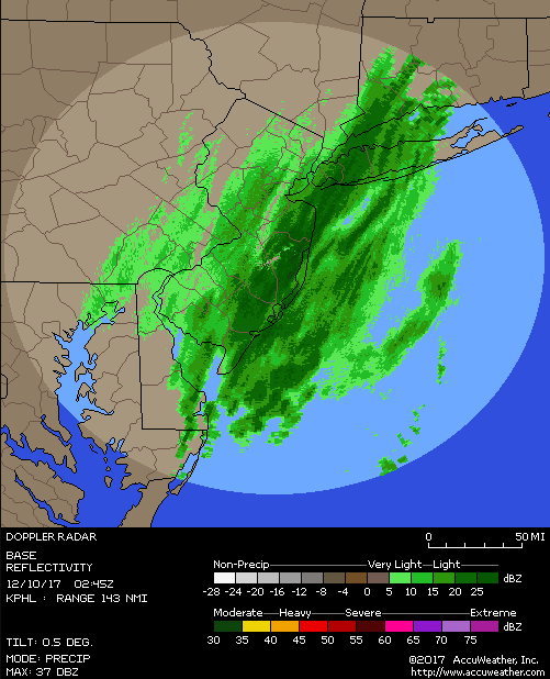
In some of the heavier snow bands as we speak!
Math23x7- Wx Statistician Guru

- Posts : 2379
Join date : 2013-01-08
Re: December 9th Storm - Snow Map
![]() by Math23x7 Sat Dec 09, 2017 9:56 pm
by Math23x7 Sat Dec 09, 2017 9:56 pm
Queens/Nassau county border getting good rates!
Math23x7- Wx Statistician Guru
- Posts : 2379
Reputation : 68
Join date : 2013-01-08
Re: December 9th Storm - Snow Map
![]() by Dunnzoo Sat Dec 09, 2017 10:13 pm
by Dunnzoo Sat Dec 09, 2017 10:13 pm
5" for the day, not bad considering we were initially in the 1-3"
_________________
Janet
Snowfall winter of 2023-2024 17.5"
Snowfall winter of 2022-2023 6.0"
Snowfall winter of 2021-2022 17.6" 1" sleet 2/25/22
Snowfall winter of 2020-2021 51.1"
Snowfall winter of 2019-2020 8.5"
Snowfall winter of 2018-2019 25.1"
Snowfall winter of 2017-2018 51.9"
Snowfall winter of 2016-2017 45.6"
Snowfall winter of 2015-2016 29.5"
Snowfall winter of 2014-2015 50.55"
Snowfall winter of 2013-2014 66.5"

Dunnzoo- Senior Enthusiast - Mod

- Posts : 4904
Reputation : 68
Join date : 2013-01-11
Age : 62
Location : Westwood, NJ
Re: December 9th Storm - Snow Map
![]() by Radz Sat Dec 09, 2017 10:32 pm
by Radz Sat Dec 09, 2017 10:32 pm
Seems done here, 4.25" nice early snowfall!

Radz- Pro Enthusiast

- Posts : 1028
Reputation : 17
Join date : 2013-01-12
Location : Cortlandt Manor NY
Re: December 9th Storm - Snow Map
![]() by MattyICE Sat Dec 09, 2017 10:33 pm
by MattyICE Sat Dec 09, 2017 10:33 pm
I know we’re not all quite done (I am, with 5” in Clifton, NJ)...but takeaways for the season from this storm? Touchy handoffs from medium range to short range? Reminder to keep eyes on dewpoints/humidity %? Interested in whether anyone has given it any thought as we move ahead.
MattyICE- Advanced Forecaster

- Posts : 249
Reputation : 6
Join date : 2017-11-10
Age : 38
Location : Clifton, NJ (Eastern Passaic County)
Re: December 9th Storm - Snow Map
![]() by hyde345 Sat Dec 09, 2017 11:04 pm
by hyde345 Sat Dec 09, 2017 11:04 pm
Picked up 5. Nice first storm of the season.

hyde345- Pro Enthusiast
- Posts : 1082
Reputation : 48
Join date : 2013-01-08
Location : Hyde Park, NY
Re: December 9th Storm - Snow Map
![]() by Guest Sat Dec 09, 2017 11:07 pm
by Guest Sat Dec 09, 2017 11:07 pm
Closing in on 5”. One more good band coming through. Snow last 3 hours much fluffier. Just shoveled 2.5” off the pavement. If you don’t know better many people won’t measure this correctly.
Guest- Guest
Re: December 9th Storm - Snow Map
![]() by Brookster Sun Dec 10, 2017 12:57 am
by Brookster Sun Dec 10, 2017 12:57 am
5” exactly on the top of College Hill in Easton, PA. I was expecting to top out at 3 so this one definitely over performed. Not too shabby for this early in the season!
Brookster- Posts : 20
Reputation : 0
Join date : 2013-11-26
Age : 40
Location : Hampton, NJ
Re: December 9th Storm - Snow Map
![]() by amugs Sun Dec 10, 2017 9:24 am
by amugs Sun Dec 10, 2017 9:24 am
5.5" here!!! LMAO MUHAHAHAHSHAHADunnzoo wrote:5" for the day, not bad considering we were initially in the 1-3"

By who NWS Upton the 1-3, LEE G?? They all are conservative until about 12 hours before it hits up here.
With that PNA I always thought this was a good 3 " plus type system sista.
Alex knows this firsthand.
Clipper add the refresher and then the bottom drops out of temp or Dec for a few days. Ala 1993, look for a bigger or same style system end of the week again.
_________________
Mugs
AKA:King: Snow Weenie
Self Proclaimed
WINTER 2014-15 : 55.12" +.02 for 6 coatings (avg. 35")
WINTER 2015-16 Total - 29.8" (Avg 35")
WINTER 2016-17 : 39.5" so far

amugs- Advanced Forecaster - Mod
- Posts : 15095
Reputation : 213
Join date : 2013-01-07
Age : 54
Location : Hillsdale,NJ
Re: December 9th Storm - Snow Map
![]() by amugs Sun Dec 10, 2017 9:27 am
by amugs Sun Dec 10, 2017 9:27 am
LOCATION STORM TOTAL TIME/DATE COMMENTS
SNOWFALL OF
/INCHES/ MEASUREMENT
CONNECTICUT
...Fairfield County...
Shelton 7.0 1115 PM 12/09 Trained Spotter
Monroe 6.9 1115 PM 12/09 Trained Spotter
New Canaan 6.8 1035 PM 12/09 Trained Spotter
Danbury 6.0 900 PM 12/09 CT DOT
Easton 6.0 1030 PM 12/09 Public
Fairfield 5.8 1100 PM 12/09 Public
Stamford 5.5 1201 AM 12/10 Trained Spotter
Weston 5.0 1125 PM 12/09 Trained Spotter
Darien 4.5 900 PM 12/09 CT DOT
Greenwich 4.5 1100 PM 12/09 Trained Spotter
BRIDGEPORT AIRPORT 4.4 1200 AM 12/10 CO-OP Observer
Stratford 4.0 900 PM 12/09 Trained Spotter
Huntington 3.3 1120 PM 12/09 Public
...New Haven County...
North Haven 7.0 1030 PM 12/09 Trained Spotter
Waterbury 6.3 1130 PM 12/09 Trained Spotter
Southbury 5.5 830 PM 12/09 Public
Seymour 5.4 1000 PM 12/09 Trained Spotter
Hamden 5.1 810 PM 12/09 Trained Spotter
Meriden 5.0 900 PM 12/09 CT DOT
Branford 4.5 1200 AM 12/10 Trained Spotter
West Haven 4.1 1125 PM 12/09 Public
Milford 3.8 830 PM 12/09 Social Media
...New London County...
Norwich 4.0 900 PM 12/09 CT DOT
Ledyard Center 2.6 900 PM 12/09 Trained Spotter
Groton 2.0 900 PM 12/09 CT DOT
NEW JERSEY
...Bergen County...
Fort Lee 5.5 1030 PM 12/09 Trained Spotter
Ridgewood 4.7 1000 PM 12/09 Trained Spotter
Franklin Lakes 4.7 920 PM 12/09 Public
River Vale 4.5 945 PM 12/09 Trained Spotter
Allendale 4.0 920 PM 12/09 Public
...Eastern Union County...
NEWARK AIRPORT 4.3 1200 AM 12/10 FAA CONTRACT OBSERVER
...Essex County...
Cedar Grove 5.1 1110 PM 12/09 Public
Roseland 4.9 1000 PM 12/09 Trained Spotter
West Orange 4.5 1030 PM 12/09 Public
...Hudson County...
Harrison 5.0 900 PM 12/09 Co-Op Observer
Kearny 4.2 1230 AM 12/10 Trained Spotter
...Passaic County...
West Milford 5.3 1010 PM 12/09 Trained Spotter
Wayne 4.7 1159 PM 12/09 TRAINED SPOTTER
Bloomingdale 3.1 1000 PM 12/09 Trained Spotter
...Union County...
Plainfield 5.5 930 PM 12/09 Trained Spotter
NEW YORK
...Bronx County...
1 NE Riverdale 3.5 830 PM 12/09 CoCoRaHS
...Kings County...
1 S Flatlands 4.4 900 PM 12/09 Public
Sheepshead Bay 3.0 1130 PM 12/09 Trained Spotter
Midwood 2.0 945 PM 12/09 Social Media
...Nassau County...
Merrick 3.9 1159 PM 12/09 Trained Spotter
Rockville Centre 3.1 1029 PM 12/09 Public
Plainview 3.0 845 PM 12/09 Trained Spotter
Carle Place 2.8 800 PM 12/09 Trained Spotter
North Merrick 2.8 830 PM 12/09 Broadcast Media
New Hyde Park 2.2 800 PM 12/09 Trained Spotter
...New York County...
CENTRAL PARK 4.6 1200 AM 12/10 Park Conservancy
...Orange County...
Monroe 6.0 930 PM 12/09 Trained Spotter
Gardnertown 5.0 1015 PM 12/09 Trained Spotter
Goshen 4.8 900 PM 12/09 Trained Spotter
Fort Montgomery 3.8 1100 PM 12/09 Trained Spotter
...Putnam County...
Cold Spring 3.5 800 PM 12/09 Trained Spotter
...Queens County...
NYC/LA GUARDIA 4.6 1200 AM 12/10 FAA CONTRACT OBSERVER
Little Neck 3.7 1030 PM 12/09 Trained Spotter
NYC/JFK AIRPORT 3.4 1200 AM 12/10 FAA CONTRACT OBSERVER
Whitestone 3.1 800 PM 12/09 Trained Spotter
Cedar Manor 2.7 800 PM 12/09 CoCoRaHS
...Richmond County...
Port Richmond 6.1 1000 PM 12/09 Trained Spotter
...Rockland County...
New City 4.0 1015 PM 12/09 Trained Spotter
Stony Point 3.0 1030 PM 12/09 Public
...Suffolk County...
Centerport 4.8 1025 PM 12/09 Co-Op Observer
Commack 4.0 930 PM 12/09 Public
Setauket 3.5 1100 PM 12/09 NWS Employee
Terryville 3.4 920 PM 12/09 Trained Spotter
Babylon 2.9 935 PM 12/09 Social Media
Yaphank 2.0 1100 PM 12/09 Public
Upton 1.4 100 AM 12/10 NWS Office
ISLIP AIRPORT 1.3 1200 AM 12/10 FAA CONTRACT OBSERVER
...Westchester County...
Armonk 6.1 945 PM 12/09 Public
Yonkers 5.0 1025 PM 12/09 Trained Spotter
Hastings-On-hudson 4.0 1212 AM 12/10 Public
Ardsley 3.3 1100 PM 12/09 Public
_________________
Mugs
AKA:King: Snow Weenie
Self Proclaimed
WINTER 2014-15 : 55.12" +.02 for 6 coatings (avg. 35")
WINTER 2015-16 Total - 29.8" (Avg 35")
WINTER 2016-17 : 39.5" so far
amugs- Advanced Forecaster - Mod
- Posts : 15095
Reputation : 213
Join date : 2013-01-07
Age : 54
Location : Hillsdale,NJ
Re: December 9th Storm - Snow Map
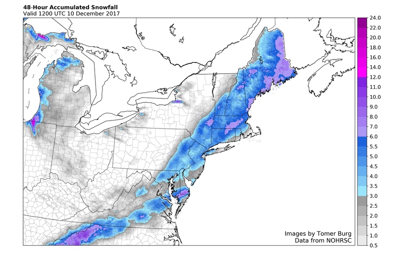
![]() by amugs Sun Dec 10, 2017 9:54 am
by amugs Sun Dec 10, 2017 9:54 am
From Tom Burg a grad met student nice map colors
_________________
Mugs
AKA:King: Snow Weenie
Self Proclaimed
WINTER 2014-15 : 55.12" +.02 for 6 coatings (avg. 35")
WINTER 2015-16 Total - 29.8" (Avg 35")
WINTER 2016-17 : 39.5" so far
amugs- Advanced Forecaster - Mod
- Posts : 15095
Reputation : 213
Join date : 2013-01-07
Age : 54
Location : Hillsdale,NJ
Re: December 9th Storm - Snow Map
![]() by sroc4 Sun Dec 10, 2017 11:18 am
by sroc4 Sun Dec 10, 2017 11:18 am
amugs wrote:From Tom Burg a grad met student nice map colors
This map is off for LI. I had 2.75”. Most of the NS of LI had over 2 with higher totals the further west you are. My buddy in Kings Park measures 4.5”
_________________
"In weather and in life, there's no winning and losing; there's only winning and learning."
WINTER 2012/2013 TOTALS 43.65"WINTER 2017/2018 TOTALS 62.85" WINTER 2022/2023 TOTALS 4.9"
WINTER 2013/2014 TOTALS 64.85"WINTER 2018/2019 TOTALS 14.25" WINTER 2023/2024 TOTALS 13.1"
WINTER 2014/2015 TOTALS 71.20"WINTER 2019/2020 TOTALS 6.35"
WINTER 2015/2016 TOTALS 35.00"WINTER 2020/2021 TOTALS 37.75"
WINTER 2016/2017 TOTALS 42.25"WINTER 2021/2022 TOTALS 31.65"

sroc4- Admin

- Posts : 8354
Reputation : 302
Join date : 2013-01-07
Location : Wading River, LI
Page 13 of 13 • 1, 2, 3 ... 11, 12, 13
Page 13 of 13
Permissions in this forum:
You cannot reply to topics in this forum|
|
|