
 Search
DEC 15 Coastal
Page 4 of 6 •  1, 2, 3, 4, 5, 6
 ![]()
Re: DEC 15 Coastal
![]() by rb924119 Fri Dec 15, 2017 1:26 pm
by rb924119 Fri Dec 15, 2017 1:26 pm
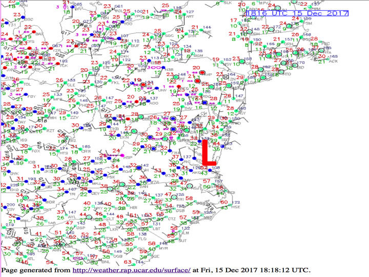
rb924119 wrote:LP center well northwest of modeling.....coming NNE over the Delmarva per latest surface observations.
rb924119- Meteorologist

- Posts : 6928
Join date : 2013-02-06
Re: DEC 15 Coastal
![]() by SENJsnowman Fri Dec 15, 2017 1:33 pm
by SENJsnowman Fri Dec 15, 2017 1:33 pm
SENJsnowman- Senior Enthusiast

- Posts : 1189
Join date : 2017-01-06
Re: DEC 15 Coastal
![]() by rb924119 Fri Dec 15, 2017 1:36 pm
by rb924119 Fri Dec 15, 2017 1:36 pm
amugs wrote:rb924119 wrote:Light snow now being reported in suburbs of Philly
Models are confused with convection as the super weenie onanoterh board has sadi along
This is so much further by about 50-75 more miles than models had
CPA was to see ugatz!!
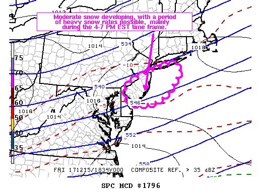
From USAwx board - this is the calculated axis of teh heavier dbz bands from teh latest Jet Streak rb? Armond? Bob? Buehler?

.thumb.gif.5ffdc9f00e0cc24a897b4b52b8519fd4.gif)

Yes Mugs, I can offer my opinion of confirmation. Given the trough axis now going negative with some interaction between northern and southern streams, *AS WELL AS* the clear northward placement of 300hPa jet by about 75 miles would support not only the centerline of heavier accumulations approximately in that zone highlighted above, but also a wider swath of those totals. This would also explain the surface low pressure being located still over the Delmarva instead of already being offshore per modeling. This could be quite the surprise for many along the I-95 corridor.
rb924119- Meteorologist
- Posts : 6928
Reputation : 194
Join date : 2013-02-06
Age : 32
Location : Greentown, Pa
Re: DEC 15 Coastal
![]() by Math23x7 Fri Dec 15, 2017 1:38 pm
by Math23x7 Fri Dec 15, 2017 1:38 pm
Math23x7- Wx Statistician Guru

- Posts : 2379
Reputation : 68
Join date : 2013-01-08
Re: DEC 15 Coastal
![]() by rb924119 Fri Dec 15, 2017 1:38 pm
by rb924119 Fri Dec 15, 2017 1:38 pm
SENJsnowman wrote:Is that bad for the shore? It don't sound good. Sounds like its gonna push all the hard stuff N and W of us...
Not necessarily, snowman, because being further east will also allow the mesoscale banding to be more mature as it rotates through your area, so while you should see a shorter duration, you should also see heavier rates as it pulls out.
rb924119- Meteorologist
- Posts : 6928
Reputation : 194
Join date : 2013-02-06
Age : 32
Location : Greentown, Pa
Re: DEC 15 Coastal
![]() by nutleyblizzard Fri Dec 15, 2017 1:42 pm
by nutleyblizzard Fri Dec 15, 2017 1:42 pm

nutleyblizzard- Senior Enthusiast
- Posts : 1954
Reputation : 41
Join date : 2014-01-30
Age : 58
Location : Nutley, new jersey
Re: DEC 15 Coastal
![]() by rb924119 Fri Dec 15, 2017 1:42 pm
by rb924119 Fri Dec 15, 2017 1:42 pm
rb924119- Meteorologist
- Posts : 6928
Reputation : 194
Join date : 2013-02-06
Age : 32
Location : Greentown, Pa
Re: DEC 15 Coastal
![]() by SENJsnowman Fri Dec 15, 2017 1:44 pm
by SENJsnowman Fri Dec 15, 2017 1:44 pm
rb924119 wrote:SENJsnowman wrote:Is that bad for the shore? It don't sound good. Sounds like its gonna push all the hard stuff N and W of us...
Not necessarily, snowman, because being further east will also allow the mesoscale banding to be more mature as it rotates through your area, so while you should see a shorter duration, you should also see heavier rates as it pulls out.
Got it thanks!
I just looked at the TWC future radar and could see exactly what you were talking about. The shore doesn't get enveloped until 4 pm, but when it does it's a darker shade of blue than what was hitting everyone else to nw. We are going to get drilled for 3 hours.
Ha ha! I'll take that for sure!!
Last edited by SENJsnowman on Fri Dec 15, 2017 1:49 pm; edited 1 time in total
SENJsnowman- Senior Enthusiast
- Posts : 1189
Reputation : 61
Join date : 2017-01-06
Age : 51
Location : Bayville, NJ
Re: DEC 15 Coastal
![]() by rb924119 Fri Dec 15, 2017 1:47 pm
by rb924119 Fri Dec 15, 2017 1:47 pm
nutleyblizzard wrote:So RB in your opinion are we looking at warning criteria snows for the NJ-NYC metro area?
I think any of those will be very isolated simply because of the speed of this system, but highest probability of those will probably be right along I-95. That said, I think high-end advisory criteria (4-5") will be fairly attainable. I was crunching some numbers earlier and it looks like snowfall ratios will average near 17:1. With the forcing in place, decent crystal growth in the DGZ should occur, so once it starts it should start stacking pretty quickly, and with projected LE QPF of about .25-.3", that fits. Not to mention that the ground is very cold, so melting on contact will not be an issue as it was with the first system.
rb924119- Meteorologist
- Posts : 6928
Reputation : 194
Join date : 2013-02-06
Age : 32
Location : Greentown, Pa
Re: DEC 15 Coastal
![]() by oldtimer Fri Dec 15, 2017 1:49 pm
by oldtimer Fri Dec 15, 2017 1:49 pm
oldtimer- Senior Enthusiast
- Posts : 1103
Reputation : 14
Join date : 2013-01-16
Age : 78
Location : Port Jefferson Station Suffolk County
Re: DEC 15 Coastal
![]() by rb924119 Fri Dec 15, 2017 1:51 pm
by rb924119 Fri Dec 15, 2017 1:51 pm
oldtimer wrote:Am I still in line for 1-3 in Central Suffolk or has it changed? Thanks
Yup, maybe 2-4" or even 3-5" on the highest end given trends in recent banding features and their direction.
Last edited by rb924119 on Fri Dec 15, 2017 1:56 pm; edited 1 time in total
rb924119- Meteorologist
- Posts : 6928
Reputation : 194
Join date : 2013-02-06
Age : 32
Location : Greentown, Pa

SoulSingMG- Senior Enthusiast
- Posts : 2853
Reputation : 74
Join date : 2013-12-11
Location : Long Island City, NY
Re: DEC 15 Coastal
![]() by docstox12 Fri Dec 15, 2017 1:56 pm
by docstox12 Fri Dec 15, 2017 1:56 pm

docstox12- Wx Statistician Guru
- Posts : 8530
Reputation : 222
Join date : 2013-01-07
Age : 73
Location : Monroe NY
Re: DEC 15 Coastal
![]() by jmanley32 Fri Dec 15, 2017 2:10 pm
by jmanley32 Fri Dec 15, 2017 2:10 pm

jmanley32- Senior Enthusiast
- Posts : 20535
Reputation : 108
Join date : 2013-12-12
Age : 43
Location : Yonkers, NY
jmanley32- Senior Enthusiast
- Posts : 20535
Reputation : 108
Join date : 2013-12-12
Age : 43
Location : Yonkers, NY
Re: DEC 15 Coastal
![]() by skinsfan1177 Fri Dec 15, 2017 2:13 pm
by skinsfan1177 Fri Dec 15, 2017 2:13 pm

skinsfan1177- Senior Enthusiast
- Posts : 4485
Reputation : 35
Join date : 2013-01-07
Age : 46
Location : Point Pleasant Boro
Re: DEC 15 Coastal
![]() by frank 638 Fri Dec 15, 2017 2:15 pm
by frank 638 Fri Dec 15, 2017 2:15 pm
frank 638- Senior Enthusiast
- Posts : 2843
Reputation : 37
Join date : 2016-01-01
Age : 40
Location : bronx ny
Re: DEC 15 Coastal
![]() by track17 Fri Dec 15, 2017 2:17 pm
by track17 Fri Dec 15, 2017 2:17 pm
track17- Posts : 454
Reputation : 4
Join date : 2016-01-09
Re: DEC 15 Coastal
![]() by SENJsnowman Fri Dec 15, 2017 2:18 pm
by SENJsnowman Fri Dec 15, 2017 2:18 pm
skinsfan1177 wrote:Just flurries here on coast I hope it picks up any input on current info for cnj coast
Looks like it's starting to pick up here in Bayville skins. Plus it seems on the TWC radar that the band is expanding SE (right over us) as we speak.
SENJsnowman- Senior Enthusiast
- Posts : 1189
Reputation : 61
Join date : 2017-01-06
Age : 51
Location : Bayville, NJ
Re: DEC 15 Coastal
![]() by aiannone Fri Dec 15, 2017 2:21 pm
by aiannone Fri Dec 15, 2017 2:21 pm
_________________
-Alex Iannone-

aiannone- Senior Enthusiast - Mod

- Posts : 4815
Reputation : 92
Join date : 2013-01-07
Location : Saint James, LI (Northwest Suffolk Co.)
Re: DEC 15 Coastal
![]() by sroc4 Fri Dec 15, 2017 2:33 pm
by sroc4 Fri Dec 15, 2017 2:33 pm
'

_________________
"In weather and in life, there's no winning and losing; there's only winning and learning."
WINTER 2012/2013 TOTALS 43.65"WINTER 2017/2018 TOTALS 62.85" WINTER 2022/2023 TOTALS 4.9"
WINTER 2013/2014 TOTALS 64.85"WINTER 2018/2019 TOTALS 14.25" WINTER 2023/2024 TOTALS 13.1"
WINTER 2014/2015 TOTALS 71.20"WINTER 2019/2020 TOTALS 6.35"
WINTER 2015/2016 TOTALS 35.00"WINTER 2020/2021 TOTALS 37.75"
WINTER 2016/2017 TOTALS 42.25"WINTER 2021/2022 TOTALS 31.65"

sroc4- Admin

- Posts : 8354
Reputation : 302
Join date : 2013-01-07
Location : Wading River, LI

Scullybutcher- Pro Enthusiast

- Posts : 543
Reputation : 16
Join date : 2013-02-06
Location : North Smithtown, western Suffolk county, long island
Re: DEC 15 Coastal
![]() by rb924119 Fri Dec 15, 2017 2:52 pm
by rb924119 Fri Dec 15, 2017 2:52 pm
rb924119- Meteorologist
- Posts : 6928
Reputation : 194
Join date : 2013-02-06
Age : 32
Location : Greentown, Pa
Re: DEC 15 Coastal
![]() by jmanley32 Fri Dec 15, 2017 2:53 pm
by jmanley32 Fri Dec 15, 2017 2:53 pm
jmanley32- Senior Enthusiast
- Posts : 20535
Reputation : 108
Join date : 2013-12-12
Age : 43
Location : Yonkers, NY
Re: DEC 15 Coastal
![]() by SENJsnowman Fri Dec 15, 2017 2:56 pm
by SENJsnowman Fri Dec 15, 2017 2:56 pm
SENJsnowman- Senior Enthusiast
- Posts : 1189
Reputation : 61
Join date : 2017-01-06
Age : 51
Location : Bayville, NJ
Re: DEC 15 Coastal
![]() by skinsfan1177 Fri Dec 15, 2017 2:59 pm
by skinsfan1177 Fri Dec 15, 2017 2:59 pm
SENJsnowman wrote:Looks like I'm getting bigger flakes now and that the banding is expanding over the shore
Yeah darker greens on radar
skinsfan1177- Senior Enthusiast
- Posts : 4485
Reputation : 35
Join date : 2013-01-07
Age : 46
Location : Point Pleasant Boro
Re: DEC 15 Coastal
![]() by rb924119 Fri Dec 15, 2017 3:05 pm
by rb924119 Fri Dec 15, 2017 3:05 pm
rb924119- Meteorologist
- Posts : 6928
Reputation : 194
Join date : 2013-02-06
Age : 32
Location : Greentown, Pa
Page 4 of 6 • 1, 2, 3, 4, 5, 6 ![]()
|
|
|