
 Search
Long Range Thread 16.0
Page 27 of 40 •  1 ... 15 ... 26, 27, 28 ... 33 ... 40
 ![]()
Re: Long Range Thread 16.0
![]() by amugs Fri Jan 12, 2018 3:32 pm
by amugs Fri Jan 12, 2018 3:32 pm
There are many mechanisms that are in conflict and muted or overriding this. It is a complex set up that starts in the Indian Ocean region with the MJO that is in a strong phase 2 into 3 next week. As Sroc pointed out and Dr,. Cohen wrote about this week we have a good attack of the PV that is being forecasted to elongate and stretch out like it did on December for latter Januray but more so into earl February.
WE have PAC wave breaks lined up again that woudl help rebuild the EPO down teh road and a poleward extension of teh PNA. One thing that is evident is a frigid Canada that will remain frigid and snowy.
amugs- Advanced Forecaster - Mod

- Posts : 15093
Join date : 2013-01-07

amugs- Advanced Forecaster - Mod
- Posts : 15093
Join date : 2013-01-07
Re: Long Range Thread 16.0
![]() by jmanley32 Fri Jan 12, 2018 5:39 pm
by jmanley32 Fri Jan 12, 2018 5:39 pm

jmanley32- Senior Enthusiast

- Posts : 20517
Reputation : 108
Join date : 2013-12-12
Age : 42
Location : Yonkers, NY
Re: Long Range Thread 16.0
![]() by Guest Fri Jan 12, 2018 9:50 pm
by Guest Fri Jan 12, 2018 9:50 pm
Guest- Guest
Re: Long Range Thread 16.0
![]() by jmanley32 Fri Jan 12, 2018 10:12 pm
by jmanley32 Fri Jan 12, 2018 10:12 pm
jmanley32- Senior Enthusiast
- Posts : 20517
Reputation : 108
Join date : 2013-12-12
Age : 42
Location : Yonkers, NY
Re: Long Range Thread 16.0
![]() by CPcantmeasuresnow Fri Jan 12, 2018 10:46 pm
by CPcantmeasuresnow Fri Jan 12, 2018 10:46 pm
Math23x7 wrote:Starting late next week, a west coast trough looks to make its presence which is bad news for snow lovers in the east. Not only that, the ensembles and EURO weeklies have this aforementioned trough lasting for weeks. If we don't get snow next week, it may be a while before we get another shot. Perhaps in late February the ridge out west returns to put us back in the snow chances. But that's not a guarantee.
Late February????
You really do enjoy dabbling on the dark side. Syos has a nice room ready for you Mikey, take him up on his offer before the dark side consumes you.

CPcantmeasuresnow- Wx Statistician Guru

- Posts : 7274
Reputation : 230
Join date : 2013-01-07
Age : 103
Location : Eastern Orange County, NY
Re: Long Range Thread 16.0
![]() by dkodgis Sat Jan 13, 2018 1:24 pm
by dkodgis Sat Jan 13, 2018 1:24 pm

dkodgis- Senior Enthusiast
- Posts : 2505
Reputation : 98
Join date : 2013-12-29
Re: Long Range Thread 16.0
![]() by weatherwatchermom Sat Jan 13, 2018 1:29 pm
by weatherwatchermom Sat Jan 13, 2018 1:29 pm
dkodgis wrote:Ladies and Gentlemen, and children of all ages. What does Tuesday look like in terms of snow?
Iwas wondering the same thing this morning, but no one really weighing in...I am guessing slim...
Last edited by weatherwatchermom on Sat Jan 13, 2018 2:54 pm; edited 1 time in total

weatherwatchermom- Senior Enthusiast
- Posts : 3750
Reputation : 77
Join date : 2014-11-25
Age : 60
Location : Hazlet Township, NJ
Re: Long Range Thread 16.0
![]() by Frank_Wx Sat Jan 13, 2018 1:37 pm
by Frank_Wx Sat Jan 13, 2018 1:37 pm
_________________
_______________________________________________________________________________________________________
CLICK HERE to view NJ Strong Snowstorm Classifications

Frank_Wx- Godzilla Seeker

- Posts : 21305
Reputation : 328
Join date : 2013-01-05
Age : 31
Location : Jersey City, NJ -

Re: Long Range Thread 16.0
![]() by Guest Sat Jan 13, 2018 2:19 pm
by Guest Sat Jan 13, 2018 2:19 pm
Frank_Wx wrote:Late Tuesday into Wednesday there may be a period of light snow. At the moment looks like minor accumulations. Maybe a couple of inches. The baroclinic zone is too far east which takes the low pressure system that develops out to sea, essentially. The cold is back next week. But storm wise, does not look like much at this time. Keeping the SCI at 5% for now.
Another EURO fail. I say we ban that model from this forum.
Guest- Guest
Re: Long Range Thread 16.0
![]() by weatherwatchermom Sat Jan 13, 2018 2:57 pm
by weatherwatchermom Sat Jan 13, 2018 2:57 pm
Frank_Wx wrote:Late Tuesday into Wednesday there may be a period of light snow. At the moment looks like minor accumulations. Maybe a couple of inches. The baroclinic zone is too far east which takes the low pressure system that develops out to sea, essentially. The cold is back next week. But storm wise, does not look like much at this time. Keeping the SCI at 5% for now.
do you see anything over the horizon???
weatherwatchermom- Senior Enthusiast
- Posts : 3750
Reputation : 77
Join date : 2014-11-25
Age : 60
Location : Hazlet Township, NJ
Re: Long Range Thread 16.0
![]() by Frank_Wx Sat Jan 13, 2018 3:27 pm
by Frank_Wx Sat Jan 13, 2018 3:27 pm
weatherwatchermom wrote:Frank_Wx wrote:Late Tuesday into Wednesday there may be a period of light snow. At the moment looks like minor accumulations. Maybe a couple of inches. The baroclinic zone is too far east which takes the low pressure system that develops out to sea, essentially. The cold is back next week. But storm wise, does not look like much at this time. Keeping the SCI at 5% for now.
do you see anything over the horizon???
Not really. After the cold passes next week it looks like there will be one or two storms that cut to our west. I do not see enough blocking to keep these storms from cutting. So we may go into another transient warm spell.
_________________
_______________________________________________________________________________________________________
CLICK HERE to view NJ Strong Snowstorm Classifications
Frank_Wx- Godzilla Seeker
- Posts : 21305
Reputation : 328
Join date : 2013-01-05
Age : 31
Location : Jersey City, NJ -
Re: Long Range Thread 16.0
![]() by Snow88 Sat Jan 13, 2018 10:58 pm
by Snow88 Sat Jan 13, 2018 10:58 pm
It's too early to give up on any of the waves . We have seen big shifts very close to an event this season.

Snow88- Senior Enthusiast
- Posts : 2193
Reputation : 4
Join date : 2013-01-09
Age : 35
Location : Brooklyn, NY
Re: Long Range Thread 16.0
![]() by Snow88 Sat Jan 13, 2018 11:08 pm
by Snow88 Sat Jan 13, 2018 11:08 pm
2+ inches for NYC with more in eastern SNE
Snow88- Senior Enthusiast
- Posts : 2193
Reputation : 4
Join date : 2013-01-09
Age : 35
Location : Brooklyn, NY
Re: Long Range Thread 16.0
![]() by amugs Sat Jan 13, 2018 11:51 pm
by amugs Sat Jan 13, 2018 11:51 pm
Snow88 wrote:Nam, GFS and CMC with some nice improvements tonight with wave 1
It's too early to give up on any of the waves . We have seen big shifts very close to an event this season.
I totally concur. Real busy day.
Nice shifts an dimptovements. Th LP in these situations like to ride the Arctic front. Also the WAR has been underestimatedone ALL frigging season. It will help push the LP west. How far remains to be seen . Like to see more improvements as we head into manna through 12z. This has been the MO of the stormsame all winter.
Not saying a major storn here folk's at this time but a way to get winter back.
_________________
Mugs
AKA:King: Snow Weenie
Self Proclaimed
WINTER 2014-15 : 55.12" +.02 for 6 coatings (avg. 35")
WINTER 2015-16 Total - 29.8" (Avg 35")
WINTER 2016-17 : 39.5" so far

amugs- Advanced Forecaster - Mod
- Posts : 15093
Reputation : 213
Join date : 2013-01-07
Age : 54
Location : Hillsdale,NJ
Snow88- Senior Enthusiast
- Posts : 2193
Reputation : 4
Join date : 2013-01-09
Age : 35
Location : Brooklyn, NY
Re: Long Range Thread 16.0
![]() by RJB8525 Sun Jan 14, 2018 9:35 am
by RJB8525 Sun Jan 14, 2018 9:35 am

RJB8525- Senior Enthusiast
- Posts : 1994
Reputation : 28
Join date : 2013-02-06
Age : 38
Location : Hackettstown, NJ
Re: Long Range Thread 16.0
![]() by Snow88 Sun Jan 14, 2018 9:47 am
by Snow88 Sun Jan 14, 2018 9:47 am
Pivotal weather snowmap has about 0.50-1 inch for the City with 3 + inches towards eastern LI and SNE
West of 6z though
The 2nd wave is also closer to the coast
Snow88- Senior Enthusiast
- Posts : 2193
Reputation : 4
Join date : 2013-01-09
Age : 35
Location : Brooklyn, NY
Re: Long Range Thread 16.0
![]() by amugs Sun Jan 14, 2018 9:58 am
by amugs Sun Jan 14, 2018 9:58 am
_________________
Mugs
AKA:King: Snow Weenie
Self Proclaimed
WINTER 2014-15 : 55.12" +.02 for 6 coatings (avg. 35")
WINTER 2015-16 Total - 29.8" (Avg 35")
WINTER 2016-17 : 39.5" so far
amugs- Advanced Forecaster - Mod
- Posts : 15093
Reputation : 213
Join date : 2013-01-07
Age : 54
Location : Hillsdale,NJ
Re: Long Range Thread 16.0
![]() by sroc4 Sun Jan 14, 2018 11:48 am
by sroc4 Sun Jan 14, 2018 11:48 am

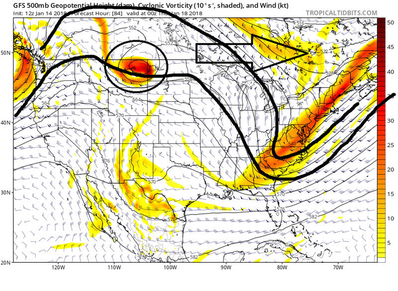
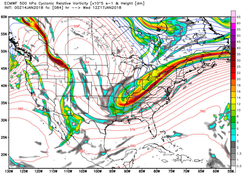
As you can see on the NAM its much weaker and strung out N to S. The result is to keep the PNA ridge intact allowing the N stream energy to dig and actualy cutoff to an ULL. As you can see by hr 84 on both GFS and NAM the 546 thickness line is well off the SE coast on the GFS vs up into NE on the NAM. With higher heights along the coast it allows for the surface LP to come up closer to the coast.
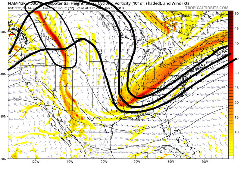
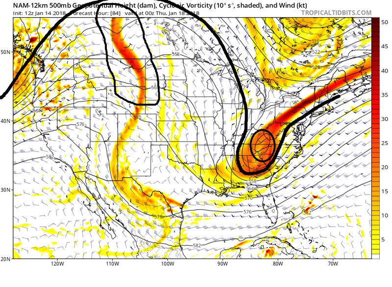
CMC is like the GFS but the Euro is closer to the NAM by hr 72. I would have to lean towards the more progressive soln for the second system for now, but as we've seen many times over this season trends under 48-72 hrs are not unusual. Hopefully we can at least pull a few inches from Tuesday.

_________________
"In weather and in life, there's no winning and losing; there's only winning and learning."
WINTER 2012/2013 TOTALS 43.65"WINTER 2017/2018 TOTALS 62.85" WINTER 2022/2023 TOTALS 4.9"
WINTER 2013/2014 TOTALS 64.85"WINTER 2018/2019 TOTALS 14.25" WINTER 2023/2024 TOTALS 13.1"
WINTER 2014/2015 TOTALS 71.20"WINTER 2019/2020 TOTALS 6.35"
WINTER 2015/2016 TOTALS 35.00"WINTER 2020/2021 TOTALS 37.75"
WINTER 2016/2017 TOTALS 42.25"WINTER 2021/2022 TOTALS 31.65"

sroc4- Admin
- Posts : 8331
Reputation : 301
Join date : 2013-01-07
Location : Wading River, LI
Re: Long Range Thread 16.0
![]() by aiannone Sun Jan 14, 2018 12:01 pm
by aiannone Sun Jan 14, 2018 12:01 pm
_________________
-Alex Iannone-

aiannone- Senior Enthusiast - Mod
- Posts : 4814
Reputation : 92
Join date : 2013-01-07
Location : Saint James, LI (Northwest Suffolk Co.)
Re: Long Range Thread 16.0
![]() by aiannone Sun Jan 14, 2018 2:35 pm
by aiannone Sun Jan 14, 2018 2:35 pm

_________________
-Alex Iannone-
aiannone- Senior Enthusiast - Mod
- Posts : 4814
Reputation : 92
Join date : 2013-01-07
Location : Saint James, LI (Northwest Suffolk Co.)


SoulSingMG- Senior Enthusiast
- Posts : 2853
Reputation : 74
Join date : 2013-12-11
Location : Long Island City, NY
Re: Long Range Thread 16.0
![]() by snowday111 Sun Jan 14, 2018 3:48 pm
by snowday111 Sun Jan 14, 2018 3:48 pm
snowday111- Posts : 92
Reputation : 1
Join date : 2013-01-07
Location : Monroe Twp. NJ (Middlesex County)
Re: Long Range Thread 16.0
![]() by aiannone Sun Jan 14, 2018 3:52 pm
by aiannone Sun Jan 14, 2018 3:52 pm
_________________
-Alex Iannone-
aiannone- Senior Enthusiast - Mod
- Posts : 4814
Reputation : 92
Join date : 2013-01-07
Location : Saint James, LI (Northwest Suffolk Co.)
Re: Long Range Thread 16.0
![]() by amugs Sun Jan 14, 2018 4:23 pm
by amugs Sun Jan 14, 2018 4:23 pm
Now some EPS individual members have that amplifing to the degree where it stalls the storm off the NJ coast which would cause a sharp cut off N& w and the city again. If kle set up but very intruining and exciting at the same time.
Off to my sons hi key game check back after the game peeps.
Great trends at h5 today.
_________________
Mugs
AKA:King: Snow Weenie
Self Proclaimed
WINTER 2014-15 : 55.12" +.02 for 6 coatings (avg. 35")
WINTER 2015-16 Total - 29.8" (Avg 35")
WINTER 2016-17 : 39.5" so far
amugs- Advanced Forecaster - Mod
- Posts : 15093
Reputation : 213
Join date : 2013-01-07
Age : 54
Location : Hillsdale,NJ
Re: Long Range Thread 16.0
![]() by sroc4 Sun Jan 14, 2018 4:44 pm
by sroc4 Sun Jan 14, 2018 4:44 pm
_________________
"In weather and in life, there's no winning and losing; there's only winning and learning."
WINTER 2012/2013 TOTALS 43.65"WINTER 2017/2018 TOTALS 62.85" WINTER 2022/2023 TOTALS 4.9"
WINTER 2013/2014 TOTALS 64.85"WINTER 2018/2019 TOTALS 14.25" WINTER 2023/2024 TOTALS 13.1"
WINTER 2014/2015 TOTALS 71.20"WINTER 2019/2020 TOTALS 6.35"
WINTER 2015/2016 TOTALS 35.00"WINTER 2020/2021 TOTALS 37.75"
WINTER 2016/2017 TOTALS 42.25"WINTER 2021/2022 TOTALS 31.65"
sroc4- Admin
- Posts : 8331
Reputation : 301
Join date : 2013-01-07
Location : Wading River, LI
Page 27 of 40 • 1 ... 15 ... 26, 27, 28 ... 33 ... 40 ![]()
|
|
|