
 Search
Long Range Thread 16.0
Page 26 of 40 •  1 ... 14 ... 25, 26, 27 ... 33 ... 40
 ![]()
Re: Long Range Thread 16.0
![]() by jmanley32 Thu Jan 11, 2018 6:41 am
by jmanley32 Thu Jan 11, 2018 6:41 am
jmanley32- Senior Enthusiast

- Posts : 20516
Join date : 2013-12-12
Re: Long Range Thread 16.0
![]() by Frank_Wx Thu Jan 11, 2018 7:24 am
by Frank_Wx Thu Jan 11, 2018 7:24 am
I do see the snowstorm threat showing up on guidance for the middle of next week. We'll keep an eye on it. Interesting evolution.
Frank_Wx- Godzilla Seeker

- Posts : 21305
Join date : 2013-01-05 -

Re: Long Range Thread 16.0
![]() by algae888 Thu Jan 11, 2018 8:14 am
by algae888 Thu Jan 11, 2018 8:14 am
Yes very interesting negative AO nice positive PNA Ridge and an East base negative Nao block. You would think with the East base Atlantic block it would come close to the coast or even west of us however the PNA Ridge is east of the ideal spot for us which technically would put the low pressure off the coast interesting model runs coming up the next few daysFrank_Wx wrote:Put out an update on the weekend storm in the January thread.
I do see the snowstorm threat showing up on guidance for the middle of next week. We'll keep an eye on it. Interesting evolution.

algae888- Advanced Forecaster

- Posts : 5311
Reputation : 46
Join date : 2013-02-05
Age : 61
Location : mt. vernon, new york
Re: Long Range Thread 16.0
![]() by Frank_Wx Thu Jan 11, 2018 10:53 am
by Frank_Wx Thu Jan 11, 2018 10:53 am

_________________
_______________________________________________________________________________________________________
CLICK HERE to view NJ Strong Snowstorm Classifications

Frank_Wx- Godzilla Seeker
- Posts : 21305
Reputation : 328
Join date : 2013-01-05
Age : 31
Location : Jersey City, NJ -
Re: Long Range Thread 16.0
![]() by jmanley32 Thu Jan 11, 2018 1:54 pm
by jmanley32 Thu Jan 11, 2018 1:54 pm

jmanley32- Senior Enthusiast
- Posts : 20516
Reputation : 108
Join date : 2013-12-12
Age : 42
Location : Yonkers, NY
Re: Long Range Thread 16.0
![]() by RJB8525 Thu Jan 11, 2018 2:10 pm
by RJB8525 Thu Jan 11, 2018 2:10 pm
jmanley32 wrote:Isnt it funny, wasn't the 17th one of the so called torch dates? Now we may see a snow storm.
Bill Evans even talked about it at noon today

RJB8525- Senior Enthusiast
- Posts : 1994
Reputation : 28
Join date : 2013-02-06
Age : 38
Location : Hackettstown, NJ
Re: Long Range Thread 16.0
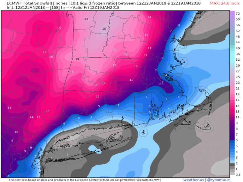
![]() by docstox12 Fri Jan 12, 2018 5:20 am
by docstox12 Fri Jan 12, 2018 5:20 am

docstox12- Wx Statistician Guru

- Posts : 8504
Reputation : 222
Join date : 2013-01-07
Age : 73
Location : Monroe NY
Re: Long Range Thread 16.0
![]() by skinsfan1177 Fri Jan 12, 2018 11:50 am
by skinsfan1177 Fri Jan 12, 2018 11:50 am


skinsfan1177- Senior Enthusiast
- Posts : 4485
Reputation : 35
Join date : 2013-01-07
Age : 46
Location : Point Pleasant Boro
Re: Long Range Thread 16.0
![]() by rb924119 Fri Jan 12, 2018 12:40 pm
by rb924119 Fri Jan 12, 2018 12:40 pm
rb924119- Meteorologist

- Posts : 6890
Reputation : 194
Join date : 2013-02-06
Age : 32
Location : Greentown, Pa
Re: Long Range Thread 16.0
![]() by docstox12 Fri Jan 12, 2018 12:48 pm
by docstox12 Fri Jan 12, 2018 12:48 pm
docstox12- Wx Statistician Guru
- Posts : 8504
Reputation : 222
Join date : 2013-01-07
Age : 73
Location : Monroe NY

skinsfan1177- Senior Enthusiast
- Posts : 4485
Reputation : 35
Join date : 2013-01-07
Age : 46
Location : Point Pleasant Boro
Re: Long Range Thread 16.0
![]() by sroc4 Fri Jan 12, 2018 1:29 pm
by sroc4 Fri Jan 12, 2018 1:29 pm
rb924119 wrote:I'm not enthused by the potential event next week. At all. It's a clipper-type system for us, which means I'm not expecting much of anything, but maybe northern New England can squeak out a bigger event from it. Even there, though, I don't think it's much of anything. Just my opinion.
Euro would have to disagree
_________________
"In weather and in life, there's no winning and losing; there's only winning and learning."
WINTER 2012/2013 TOTALS 43.65"WINTER 2017/2018 TOTALS 62.85" WINTER 2022/2023 TOTALS 4.9"
WINTER 2013/2014 TOTALS 64.85"WINTER 2018/2019 TOTALS 14.25" WINTER 2023/2024 TOTALS 13.1"
WINTER 2014/2015 TOTALS 71.20"WINTER 2019/2020 TOTALS 6.35"
WINTER 2015/2016 TOTALS 35.00"WINTER 2020/2021 TOTALS 37.75"
WINTER 2016/2017 TOTALS 42.25"WINTER 2021/2022 TOTALS 31.65"

sroc4- Admin
- Posts : 8331
Reputation : 301
Join date : 2013-01-07
Location : Wading River, LI
Re: Long Range Thread 16.0
![]() by Math23x7 Fri Jan 12, 2018 1:29 pm
by Math23x7 Fri Jan 12, 2018 1:29 pm
Math23x7- Wx Statistician Guru
- Posts : 2379
Reputation : 68
Join date : 2013-01-08
Re: Long Range Thread 16.0
![]() by sroc4 Fri Jan 12, 2018 1:38 pm
by sroc4 Fri Jan 12, 2018 1:38 pm
Math23x7 wrote:Starting late next week, a west coast trough looks to make its presence which is bad news for snow lovers in the east. Not only that, the ensembles and EURO weeklies have this aforementioned trough lasting for weeks. If we don't get snow next week, it may be a while before we get another shot. Perhaps in late February the ridge out west returns to put us back in the snow chances. But that's not a guarantee.
Perhaps late Feb?? Lol Oh Mikey. Not sure if you have looked at or understand the stratospheric influence on the horizon. But if current changes continue expect the modeling to catch up by about the 20th and you will see additional cold and snow chances show up on the models before late Feb.
_________________
"In weather and in life, there's no winning and losing; there's only winning and learning."
WINTER 2012/2013 TOTALS 43.65"WINTER 2017/2018 TOTALS 62.85" WINTER 2022/2023 TOTALS 4.9"
WINTER 2013/2014 TOTALS 64.85"WINTER 2018/2019 TOTALS 14.25" WINTER 2023/2024 TOTALS 13.1"
WINTER 2014/2015 TOTALS 71.20"WINTER 2019/2020 TOTALS 6.35"
WINTER 2015/2016 TOTALS 35.00"WINTER 2020/2021 TOTALS 37.75"
WINTER 2016/2017 TOTALS 42.25"WINTER 2021/2022 TOTALS 31.65"
sroc4- Admin
- Posts : 8331
Reputation : 301
Join date : 2013-01-07
Location : Wading River, LI
Re: Long Range Thread 16.0
![]() by sroc4 Fri Jan 12, 2018 1:41 pm
by sroc4 Fri Jan 12, 2018 1:41 pm
sroc4 wrote:rb924119 wrote:I'm not enthused by the potential event next week. At all. It's a clipper-type system for us, which means I'm not expecting much of anything, but maybe northern New England can squeak out a bigger event from it. Even there, though, I don't think it's much of anything. Just my opinion.
Euro would have to disagree
A slippery set up but doable based on what Im seeing...not just euro
_________________
"In weather and in life, there's no winning and losing; there's only winning and learning."
WINTER 2012/2013 TOTALS 43.65"WINTER 2017/2018 TOTALS 62.85" WINTER 2022/2023 TOTALS 4.9"
WINTER 2013/2014 TOTALS 64.85"WINTER 2018/2019 TOTALS 14.25" WINTER 2023/2024 TOTALS 13.1"
WINTER 2014/2015 TOTALS 71.20"WINTER 2019/2020 TOTALS 6.35"
WINTER 2015/2016 TOTALS 35.00"WINTER 2020/2021 TOTALS 37.75"
WINTER 2016/2017 TOTALS 42.25"WINTER 2021/2022 TOTALS 31.65"
sroc4- Admin
- Posts : 8331
Reputation : 301
Join date : 2013-01-07
Location : Wading River, LI
Re: Long Range Thread 16.0
![]() by rb924119 Fri Jan 12, 2018 1:58 pm
by rb924119 Fri Jan 12, 2018 1:58 pm
sroc4 wrote:sroc4 wrote:rb924119 wrote:I'm not enthused by the potential event next week. At all. It's a clipper-type system for us, which means I'm not expecting much of anything, but maybe northern New England can squeak out a bigger event from it. Even there, though, I don't think it's much of anything. Just my opinion.
Euro would have to disagree
A slippery set up but doable based on what Im seeing...not just euro
Oh don't get me wrong, Scott; I see how it can happen and can understand your point of view. My argument is that models are currently too far south and too amplified with the whole evolution based on what I'm seeing in the general Hemispheric setup. I don't see the mid-level low getting any further south than about the Mason-Dixon Line, and actually think it ends up tracking pretty much right over our area. If that's the case, even if amplified, we wind up in the "disconnect" region between the lower-levels and the mid- and upper-levels. Secondly, I think we end up with an initial closer low over the Midwest that ends up opening up, tilting positive and shearing out as the pattern breaks down. Lastly, the whole system is coming from the wrong direction. This is entirely northern stream driven, which means it has no deep moisture source (clipper). There's no southern stream energy involved, and there's no moisture transport out ahead. The entire fetch is from Canada. So, even if cyclogenesis can be induced near the coast, with how fast the pattern is, there is no way that there is going to be enough time for the system to develop enough to throw enough moisture back from the Atlantic.
rb924119- Meteorologist
- Posts : 6890
Reputation : 194
Join date : 2013-02-06
Age : 32
Location : Greentown, Pa

nutleyblizzard- Senior Enthusiast
- Posts : 1952
Reputation : 41
Join date : 2014-01-30
Age : 58
Location : Nutley, new jersey
Re: Long Range Thread 16.0
![]() by rb924119 Fri Jan 12, 2018 2:06 pm
by rb924119 Fri Jan 12, 2018 2:06 pm
sroc4 wrote:Math23x7 wrote:Starting late next week, a west coast trough looks to make its presence which is bad news for snow lovers in the east. Not only that, the ensembles and EURO weeklies have this aforementioned trough lasting for weeks. If we don't get snow next week, it may be a while before we get another shot. Perhaps in late February the ridge out west returns to put us back in the snow chances. But that's not a guarantee.
Perhaps late Feb?? Lol Oh Mikey. Not sure if you have looked at or understand the stratospheric influence on the horizon. But if current changes continue expect the modeling to catch up by about the 20th and you will see additional cold and snow chances show up on the models before late Feb.
Strongly agree with this, though, buddy ahaha there is definitely strong support for more of a transient type of pattern, where no real "pattern" can hit hold. Instead, it looks to me like there will be a strong tendency for shortwaves to continuously crash beneath the ridge in eastern North America. If you want to know how it can snow in an overall transient, "wam" pattern; that's exactly how. Also, as I mentioned a few days ago, even though the local pattern may not look great, there are signals for coordinated Wave 1 attacks on the Stratosphere, starting in a few days. With prolonged attacks looking likely, I expect the manifestation to begin showing by the end of the first week, maybe ten days, of February, with a return to a similar pattern to what we just came out of by then. The EURO Weeklies show VERY STRONG SUPPORT for this. Actually, we are about to enter a very similar pattern to what set up our recent impressive wintry stretch.
rb924119- Meteorologist
- Posts : 6890
Reputation : 194
Join date : 2013-02-06
Age : 32
Location : Greentown, Pa
Re: Long Range Thread 16.0
![]() by rb924119 Fri Jan 12, 2018 2:09 pm
by rb924119 Fri Jan 12, 2018 2:09 pm
nutleyblizzard wrote:
Pretty map, though, I'll admit ahaha
rb924119- Meteorologist
- Posts : 6890
Reputation : 194
Join date : 2013-02-06
Age : 32
Location : Greentown, Pa
Re: Long Range Thread 16.0
![]() by sroc4 Fri Jan 12, 2018 2:14 pm
by sroc4 Fri Jan 12, 2018 2:14 pm
rb924119 wrote:sroc4 wrote:Math23x7 wrote:Starting late next week, a west coast trough looks to make its presence which is bad news for snow lovers in the east. Not only that, the ensembles and EURO weeklies have this aforementioned trough lasting for weeks. If we don't get snow next week, it may be a while before we get another shot. Perhaps in late February the ridge out west returns to put us back in the snow chances. But that's not a guarantee.
Perhaps late Feb?? Lol Oh Mikey. Not sure if you have looked at or understand the stratospheric influence on the horizon. But if current changes continue expect the modeling to catch up by about the 20th and you will see additional cold and snow chances show up on the models before late Feb.
Strongly agree with this, though, buddy ahaha there is definitely strong support for more of a transient type of pattern, where no real "pattern" can hit hold. Instead, it looks to me like there will be a strong tendency for shortwaves to continuously crash beneath the ridge in eastern North America. If you want to know how it can snow in an overall transient, "wam" pattern; that's exactly how. Also, as I mentioned a few days ago, even though the local pattern may not look great, there are signals for coordinated Wave 1 attacks on the Stratosphere, starting in a few days. With prolonged attacks looking likely, I expect the manifestation to begin showing by the end of the first week, maybe ten days, of February, with a return to a similar pattern to what we just came out of by then. The EURO Weeklies show VERY STRONG SUPPORT for this. Actually, we are about to enter a very similar pattern to what set up our recent impressive wintry stretch.
Here is a strong wave flux forecasted over the next 7-14days. You can see zonal wind anomalies are forecasted to drop off as well.

_________________
"In weather and in life, there's no winning and losing; there's only winning and learning."
WINTER 2012/2013 TOTALS 43.65"WINTER 2017/2018 TOTALS 62.85" WINTER 2022/2023 TOTALS 4.9"
WINTER 2013/2014 TOTALS 64.85"WINTER 2018/2019 TOTALS 14.25" WINTER 2023/2024 TOTALS 13.1"
WINTER 2014/2015 TOTALS 71.20"WINTER 2019/2020 TOTALS 6.35"
WINTER 2015/2016 TOTALS 35.00"WINTER 2020/2021 TOTALS 37.75"
WINTER 2016/2017 TOTALS 42.25"WINTER 2021/2022 TOTALS 31.65"
sroc4- Admin
- Posts : 8331
Reputation : 301
Join date : 2013-01-07
Location : Wading River, LI
Re: Long Range Thread 16.0
![]() by rb924119 Fri Jan 12, 2018 2:25 pm
by rb924119 Fri Jan 12, 2018 2:25 pm
sroc4 wrote:rb924119 wrote:sroc4 wrote:Math23x7 wrote:Starting late next week, a west coast trough looks to make its presence which is bad news for snow lovers in the east. Not only that, the ensembles and EURO weeklies have this aforementioned trough lasting for weeks. If we don't get snow next week, it may be a while before we get another shot. Perhaps in late February the ridge out west returns to put us back in the snow chances. But that's not a guarantee.
Perhaps late Feb?? Lol Oh Mikey. Not sure if you have looked at or understand the stratospheric influence on the horizon. But if current changes continue expect the modeling to catch up by about the 20th and you will see additional cold and snow chances show up on the models before late Feb.
Strongly agree with this, though, buddy ahaha there is definitely strong support for more of a transient type of pattern, where no real "pattern" can hit hold. Instead, it looks to me like there will be a strong tendency for shortwaves to continuously crash beneath the ridge in eastern North America. If you want to know how it can snow in an overall transient, "wam" pattern; that's exactly how. Also, as I mentioned a few days ago, even though the local pattern may not look great, there are signals for coordinated Wave 1 attacks on the Stratosphere, starting in a few days. With prolonged attacks looking likely, I expect the manifestation to begin showing by the end of the first week, maybe ten days, of February, with a return to a similar pattern to what we just came out of by then. The EURO Weeklies show VERY STRONG SUPPORT for this. Actually, we are about to enter a very similar pattern to what set up our recent impressive wintry stretch.
Here is a strong wave flux forecasted over the next 7-14days. You can see zonal wind anomalies are forecasted to drop off as well.
BINGO!! Thank you for the big assist, sir!! Haha
rb924119- Meteorologist
- Posts : 6890
Reputation : 194
Join date : 2013-02-06
Age : 32
Location : Greentown, Pa
Re: Long Range Thread 16.0
![]() by jmanley32 Fri Jan 12, 2018 2:30 pm
by jmanley32 Fri Jan 12, 2018 2:30 pm
pouch what a snow hole wth lolnutleyblizzard wrote:
jmanley32- Senior Enthusiast
- Posts : 20516
Reputation : 108
Join date : 2013-12-12
Age : 42
Location : Yonkers, NY
Re: Long Range Thread 16.0
![]() by sroc4 Fri Jan 12, 2018 2:41 pm
by sroc4 Fri Jan 12, 2018 2:41 pm
_________________
"In weather and in life, there's no winning and losing; there's only winning and learning."
WINTER 2012/2013 TOTALS 43.65"WINTER 2017/2018 TOTALS 62.85" WINTER 2022/2023 TOTALS 4.9"
WINTER 2013/2014 TOTALS 64.85"WINTER 2018/2019 TOTALS 14.25" WINTER 2023/2024 TOTALS 13.1"
WINTER 2014/2015 TOTALS 71.20"WINTER 2019/2020 TOTALS 6.35"
WINTER 2015/2016 TOTALS 35.00"WINTER 2020/2021 TOTALS 37.75"
WINTER 2016/2017 TOTALS 42.25"WINTER 2021/2022 TOTALS 31.65"
sroc4- Admin
- Posts : 8331
Reputation : 301
Join date : 2013-01-07
Location : Wading River, LI
Re: Long Range Thread 16.0
![]() by frank 638 Fri Jan 12, 2018 2:42 pm
by frank 638 Fri Jan 12, 2018 2:42 pm
frank 638- Senior Enthusiast
- Posts : 2824
Reputation : 37
Join date : 2016-01-01
Age : 40
Location : bronx ny
Re: Long Range Thread 16.0
![]() by amugs Fri Jan 12, 2018 2:42 pm
by amugs Fri Jan 12, 2018 2:42 pm
Barking at this wave 2

_________________
Mugs
AKA:King: Snow Weenie
Self Proclaimed
WINTER 2014-15 : 55.12" +.02 for 6 coatings (avg. 35")
WINTER 2015-16 Total - 29.8" (Avg 35")
WINTER 2016-17 : 39.5" so far

amugs- Advanced Forecaster - Mod

- Posts : 15093
Reputation : 213
Join date : 2013-01-07
Age : 54
Location : Hillsdale,NJ
Re: Long Range Thread 16.0
![]() by amugs Fri Jan 12, 2018 3:32 pm
by amugs Fri Jan 12, 2018 3:32 pm
There are many mechanisms that are in conflict and muted or overriding this. It is a complex set up that starts in the Indian Ocean region with the MJO that is in a strong phase 2 into 3 next week. As Sroc pointed out and Dr,. Cohen wrote about this week we have a good attack of the PV that is being forecasted to elongate and stretch out like it did on December for latter Januray but more so into earl February.
WE have PAC wave breaks lined up again that woudl help rebuild the EPO down teh road and a poleward extension of teh PNA. One thing that is evident is a frigid Canada that will remain frigid and snowy.
_________________
Mugs
AKA:King: Snow Weenie
Self Proclaimed
WINTER 2014-15 : 55.12" +.02 for 6 coatings (avg. 35")
WINTER 2015-16 Total - 29.8" (Avg 35")
WINTER 2016-17 : 39.5" so far
amugs- Advanced Forecaster - Mod
- Posts : 15093
Reputation : 213
Join date : 2013-01-07
Age : 54
Location : Hillsdale,NJ
Re: Long Range Thread 16.0
![]() by amugs Fri Jan 12, 2018 4:53 pm
by amugs Fri Jan 12, 2018 4:53 pm

_________________
Mugs
AKA:King: Snow Weenie
Self Proclaimed
WINTER 2014-15 : 55.12" +.02 for 6 coatings (avg. 35")
WINTER 2015-16 Total - 29.8" (Avg 35")
WINTER 2016-17 : 39.5" so far
amugs- Advanced Forecaster - Mod
- Posts : 15093
Reputation : 213
Join date : 2013-01-07
Age : 54
Location : Hillsdale,NJ
Page 26 of 40 • 1 ... 14 ... 25, 26, 27 ... 33 ... 40 ![]()
|
|
|