
 Search
Long Range Thread 16.0
Page 4 of 34 •  1, 2, 3, 4, 5 ... 19 ... 34
 ![]()
Re: Long Range Thread 16.0
![]() by amugs Sun Feb 18, 2018 8:42 am
by amugs Sun Feb 18, 2018 8:42 am
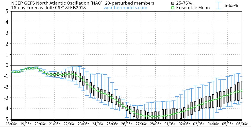
So let's look at our indices and just ton point out that I showed a few days ago the PAC wave break and EPO should respond? Well would you look at the GEFS saying Postive EPO to a MODERATELY Negative one now:
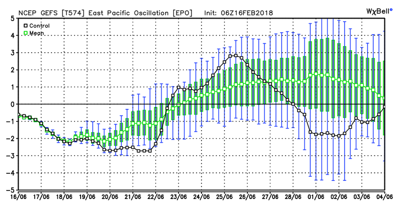
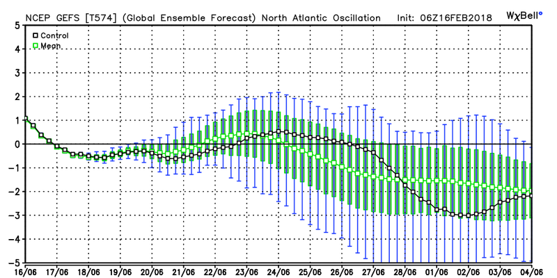
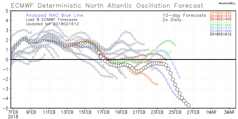
Now the NAO
Momma Mia does it tank in the Euro
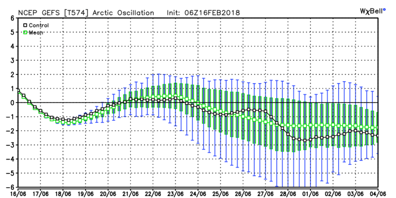
GEFS AO
amugs- Advanced Forecaster - Mod

- Posts : 15095
Join date : 2013-01-07
Re: Long Range Thread 16.0
![]() by billg315 Sun Feb 18, 2018 8:48 am
by billg315 Sun Feb 18, 2018 8:48 am
This warmth has had its run. Time for winter to come back and have its fun.
billg315- Advanced Forecaster - Mod
- Posts : 4483
Join date : 2015-01-24
Re: Long Range Thread 16.0
![]() by amugs Sun Feb 18, 2018 9:33 am
by amugs Sun Feb 18, 2018 9:33 am
Showing the PAC wave break that rejuvenates the EPO to go Negative and help with our cold air source models will lag in this as always for temps retraction

_________________
Mugs
AKA:King: Snow Weenie
Self Proclaimed
WINTER 2014-15 : 55.12" +.02 for 6 coatings (avg. 35")
WINTER 2015-16 Total - 29.8" (Avg 35")
WINTER 2016-17 : 39.5" so far

amugs- Advanced Forecaster - Mod
- Posts : 15095
Reputation : 213
Join date : 2013-01-07
Age : 54
Location : Hillsdale,NJ
Re: Long Range Thread 16.0
![]() by Quietace Sun Feb 18, 2018 11:29 am
by Quietace Sun Feb 18, 2018 11:29 am
No matter what guidance package you use, verification that far ahead is no better then climo. Pattern recognition and statistical forecasting will do much better.NjWeatherGuy wrote:If you wanna see funny look at the 6z GFS around March 4th. U.S. gotta step up our game and improve this model.

Quietace- Meteorologist - Mod

- Posts : 3689
Reputation : 33
Join date : 2013-01-07
Age : 27
Location : Point Pleasant, NJ
Re: Long Range Thread 16.0
![]() by Quietace Sun Feb 18, 2018 11:31 am
by Quietace Sun Feb 18, 2018 11:31 am
Quietace- Meteorologist - Mod
- Posts : 3689
Reputation : 33
Join date : 2013-01-07
Age : 27
Location : Point Pleasant, NJ
Re: Long Range Thread 16.0
![]() by docstox12 Sun Feb 18, 2018 11:32 am
by docstox12 Sun Feb 18, 2018 11:32 am
billg315 wrote:All signs point to some good action in early March, and it just makes sense to me not just from the data which all looks good right now, but just from experience as well. It ain’t going to stay in the 50s right into April. Things have to shift colder sometime in early March.
This warmth has had its run. Time for winter to come back and have its fun.
From my many years of observing winter around these parts, when you get a big warm up in the 60's, soon after you get the goods with a big snowstorm.Last February I saw leaves out on the trees.A few weeks later, 20 inches of snow.A mini 1888 redux where people had been sunning themselves in Central park a few days before the blizzard.

docstox12- Wx Statistician Guru

- Posts : 8530
Reputation : 222
Join date : 2013-01-07
Age : 73
Location : Monroe NY
Re: Long Range Thread 16.0
![]() by amugs Sun Feb 18, 2018 1:15 pm
by amugs Sun Feb 18, 2018 1:15 pm
docstox12 wrote:billg315 wrote:All signs point to some good action in early March, and it just makes sense to me not just from the data which all looks good right now, but just from experience as well. It ain’t going to stay in the 50s right into April. Things have to shift colder sometime in early March.
This warmth has had its run. Time for winter to come back and have its fun.
From my many years of observing winter around these parts, when you get a big warm up in the 60's, soon after you get the goods with a big snowstorm.Last February I saw leaves out on the trees.A few weeks later, 20 inches of snow.A mini 1888 redux where people had been sunning themselves in Central park a few days before the blizzard.
You remember that one ...........1888 - I didn't think people showed skin back then LOL!
How low can you go???
Jet Retraction part Duece

_________________
Mugs
AKA:King: Snow Weenie
Self Proclaimed
WINTER 2014-15 : 55.12" +.02 for 6 coatings (avg. 35")
WINTER 2015-16 Total - 29.8" (Avg 35")
WINTER 2016-17 : 39.5" so far
amugs- Advanced Forecaster - Mod
- Posts : 15095
Reputation : 213
Join date : 2013-01-07
Age : 54
Location : Hillsdale,NJ
Re: Long Range Thread 16.0
![]() by MattyICE Sun Feb 18, 2018 6:02 pm
by MattyICE Sun Feb 18, 2018 6:02 pm
MattyICE- Advanced Forecaster

- Posts : 249
Reputation : 6
Join date : 2017-11-10
Age : 38
Location : Clifton, NJ (Eastern Passaic County)
Re: Long Range Thread 16.0
![]() by Dunnzoo Sun Feb 18, 2018 6:06 pm
by Dunnzoo Sun Feb 18, 2018 6:06 pm
MattyICE wrote:I know it’s 18z and I know it’s fantasy-land...but the end of the GFS really helps show a) how the models are starting to catch on to these changes, and b) what a pattern like this is potentially capable of.
Made me look!
_________________
Janet
Snowfall winter of 2023-2024 17.5"
Snowfall winter of 2022-2023 6.0"
Snowfall winter of 2021-2022 17.6" 1" sleet 2/25/22
Snowfall winter of 2020-2021 51.1"
Snowfall winter of 2019-2020 8.5"
Snowfall winter of 2018-2019 25.1"
Snowfall winter of 2017-2018 51.9"
Snowfall winter of 2016-2017 45.6"
Snowfall winter of 2015-2016 29.5"
Snowfall winter of 2014-2015 50.55"
Snowfall winter of 2013-2014 66.5"

Dunnzoo- Senior Enthusiast - Mod
- Posts : 4904
Reputation : 68
Join date : 2013-01-11
Age : 62
Location : Westwood, NJ
Re: Long Range Thread 16.0
![]() by algae888 Sun Feb 18, 2018 7:01 pm
by algae888 Sun Feb 18, 2018 7:01 pm
Me too! It took 84 hours for the storm to go from northern Mississippi into the Gulf of Maine. This is what I was saying yesterday. there will be no 6-hour quick hitter with this pattern coming upDunnzoo wrote:MattyICE wrote:I know it’s 18z and I know it’s fantasy-land...but the end of the GFS really helps show a) how the models are starting to catch on to these changes, and b) what a pattern like this is potentially capable of.
Made me look!

algae888- Advanced Forecaster
- Posts : 5311
Reputation : 46
Join date : 2013-02-05
Age : 62
Location : mt. vernon, new york
Re: Long Range Thread 16.0
![]() by jmanley32 Mon Feb 19, 2018 4:33 pm
by jmanley32 Mon Feb 19, 2018 4:33 pm
it was never a concern if the actual driving. It's the traffic and other ppl on 95. It's usually a crappy trip to my parents in CT on a good day. Flying I can understand no one wants be stranded in airport.syosnow94 wrote:NjWeatherGuy wrote:Yeah bad timing for me to. I think we see a pattern change in March too but the 2nd week is bad for a lot of people. I'm scheduled to drive to FL to see parents so really hope the weather cooperates.
You and Janet are starting to sound like Jman now with the worry about snow and travel

jmanley32- Senior Enthusiast

- Posts : 20535
Reputation : 108
Join date : 2013-12-12
Age : 43
Location : Yonkers, NY
Re: Long Range Thread 16.0
![]() by amugs Mon Feb 19, 2018 4:38 pm
by amugs Mon Feb 19, 2018 4:38 pm

[justify][/justify
Look at that Greenland block and the massive bridge overy the Arctic to induce a negative epo. SW will eject out of the SW with a stj flow from the looks. This sets up then there will be a LOT if sleepless nights my fellow weenies.
Last edited by amugs on Mon Feb 19, 2018 4:41 pm; edited 1 time in total
_________________
Mugs
AKA:King: Snow Weenie
Self Proclaimed
WINTER 2014-15 : 55.12" +.02 for 6 coatings (avg. 35")
WINTER 2015-16 Total - 29.8" (Avg 35")
WINTER 2016-17 : 39.5" so far
amugs- Advanced Forecaster - Mod
- Posts : 15095
Reputation : 213
Join date : 2013-01-07
Age : 54
Location : Hillsdale,NJ
Re: Long Range Thread 16.0
![]() by jmanley32 Mon Feb 19, 2018 4:38 pm
by jmanley32 Mon Feb 19, 2018 4:38 pm
so we will have blocking in place? I start a new job at a school on the 26th wouldn't that be the bee's knees if I got a day off only a few days in lol.algae888 wrote:Me too! It took 84 hours for the storm to go from northern Mississippi into the Gulf of Maine. This is what I was saying yesterday. there will be no 6-hour quick hitter with this pattern coming upDunnzoo wrote:MattyICE wrote:I know it’s 18z and I know it’s fantasy-land...but the end of the GFS really helps show a) how the models are starting to catch on to these changes, and b) what a pattern like this is potentially capable of.
Made me look!
jmanley32- Senior Enthusiast
- Posts : 20535
Reputation : 108
Join date : 2013-12-12
Age : 43
Location : Yonkers, NY
Re: Long Range Thread 16.0
![]() by RJB8525 Mon Feb 19, 2018 4:39 pm
by RJB8525 Mon Feb 19, 2018 4:39 pm
jmanley32 wrote:so we will have blocking in place? I start a new job at a school on the 26th wouldn't that be the bee's knees if I got a day off only a few days in lol.algae888 wrote:Me too! It took 84 hours for the storm to go from northern Mississippi into the Gulf of Maine. This is what I was saying yesterday. there will be no 6-hour quick hitter with this pattern coming upDunnzoo wrote:MattyICE wrote:I know it’s 18z and I know it’s fantasy-land...but the end of the GFS really helps show a) how the models are starting to catch on to these changes, and b) what a pattern like this is potentially capable of.
Made me look!
congrats jman

RJB8525- Senior Enthusiast
- Posts : 1994
Reputation : 28
Join date : 2013-02-06
Age : 38
Location : Hackettstown, NJ
Re: Long Range Thread 16.0
![]() by jmanley32 Mon Feb 19, 2018 4:43 pm
by jmanley32 Mon Feb 19, 2018 4:43 pm
thanks! it's not a public school it's a private early intervention preschool that uses scientific evidence based techniques utilizing graphings each day. Many of the kids are autistic as this is becoming a proven method of early learning for those with sutism spectrum disorder. and has somewhat of a diff schedule than Yonkers public. They have a week off in April. And have a half summer program. I'm curious how they handle snow days. If they are made up by removing days from vacations or if it's built in.RJB8525 wrote:jmanley32 wrote:so we will have blocking in place? I start a new job at a school on the 26th wouldn't that be the bee's knees if I got a day off only a few days in lol.algae888 wrote:Me too! It took 84 hours for the storm to go from northern Mississippi into the Gulf of Maine. This is what I was saying yesterday. there will be no 6-hour quick hitter with this pattern coming upDunnzoo wrote:MattyICE wrote:I know it’s 18z and I know it’s fantasy-land...but the end of the GFS really helps show a) how the models are starting to catch on to these changes, and b) what a pattern like this is potentially capable of.
Made me look!
congrats jman
jmanley32- Senior Enthusiast
- Posts : 20535
Reputation : 108
Join date : 2013-12-12
Age : 43
Location : Yonkers, NY
Re: Long Range Thread 16.0
![]() by amugs Mon Feb 19, 2018 4:45 pm
by amugs Mon Feb 19, 2018 4:45 pm
1958, 2003, 1962 HOORRAAHHH!
_________________
Mugs
AKA:King: Snow Weenie
Self Proclaimed
WINTER 2014-15 : 55.12" +.02 for 6 coatings (avg. 35")
WINTER 2015-16 Total - 29.8" (Avg 35")
WINTER 2016-17 : 39.5" so far
amugs- Advanced Forecaster - Mod
- Posts : 15095
Reputation : 213
Join date : 2013-01-07
Age : 54
Location : Hillsdale,NJ
Re: Long Range Thread 16.0
![]() by amugs Mon Feb 19, 2018 4:47 pm
by amugs Mon Feb 19, 2018 4:47 pm
_________________
Mugs
AKA:King: Snow Weenie
Self Proclaimed
WINTER 2014-15 : 55.12" +.02 for 6 coatings (avg. 35")
WINTER 2015-16 Total - 29.8" (Avg 35")
WINTER 2016-17 : 39.5" so far
amugs- Advanced Forecaster - Mod
- Posts : 15095
Reputation : 213
Join date : 2013-01-07
Age : 54
Location : Hillsdale,NJ
track17- Posts : 454
Reputation : 4
Join date : 2016-01-09
Re: Long Range Thread 16.0
![]() by amugs Tue Feb 20, 2018 8:42 am
by amugs Tue Feb 20, 2018 8:42 am
More from Doug Fresh to enjoy over your morning Cup o Joe peeps:
I'm sick of the claims that the Pacific is "bad" and that the NAO "can't do it on its own", or whatever bad information gets spread on the interwebs. The -PNA trough retracting, and undercutting an increasingly -EPO pattern -- yielding a split flow and cold air drainage in NW Canada is exactly the type of Pacific pattern I'd want to coincide with this massive west-based -NAO for KU purposes. Without the -NAO, then this Pacific pattern would be bad, but with the -NAO, not only does the Pacific become "not a hindrance", but I actually think it becomes quite a good cooperator!


_________________
Mugs
AKA:King: Snow Weenie
Self Proclaimed
WINTER 2014-15 : 55.12" +.02 for 6 coatings (avg. 35")
WINTER 2015-16 Total - 29.8" (Avg 35")
WINTER 2016-17 : 39.5" so far
amugs- Advanced Forecaster - Mod
- Posts : 15095
Reputation : 213
Join date : 2013-01-07
Age : 54
Location : Hillsdale,NJ
Re: Long Range Thread 16.0
![]() by SENJsnowman Tue Feb 20, 2018 9:00 am
by SENJsnowman Tue Feb 20, 2018 9:00 am
amugs wrote:Jman congrats!!!
More from Doug Fresh to enjoy over your morning Cup o Joe peeps:
I'm sick of the claims that the Pacific is "bad" and that the NAO "can't do it on its own", or whatever bad information gets spread on the interwebs. The -PNA trough retracting, and undercutting an increasingly -EPO pattern -- yielding a split flow and cold air drainage in NW Canada is exactly the type of Pacific pattern I'd want to coincide with this massive west-based -NAO for KU purposes. Without the -NAO, then this Pacific pattern would be bad, but with the -NAO, not only does the Pacific become "not a hindrance", but I actually think it becomes quite a good cooperator!
As a matter of fact, I had the Joe in my hands as I read that line! LOL!
Thanks a ton once again Mugs, and SROC and Frank and RB and the various Al's, etc...so much great info on a regular basis from the whole long range crew. And the regular contributions from the 'ranter and raver' crew is also very helpful in understanding the info on a plain English level. Hopefully all of this comes together to give us all a nice wintry present or two in the final push here.
What is the KU and how does it help produce snow storms?
SENJsnowman- Senior Enthusiast
- Posts : 1189
Reputation : 61
Join date : 2017-01-06
Age : 51
Location : Bayville, NJ
Re: Long Range Thread 16.0
![]() by Math23x7 Tue Feb 20, 2018 1:55 pm
by Math23x7 Tue Feb 20, 2018 1:55 pm
SENJsnowman wrote:amugs wrote:Jman congrats!!!
More from Doug Fresh to enjoy over your morning Cup o Joe peeps:
I'm sick of the claims that the Pacific is "bad" and that the NAO "can't do it on its own", or whatever bad information gets spread on the interwebs. The -PNA trough retracting, and undercutting an increasingly -EPO pattern -- yielding a split flow and cold air drainage in NW Canada is exactly the type of Pacific pattern I'd want to coincide with this massive west-based -NAO for KU purposes. Without the -NAO, then this Pacific pattern would be bad, but with the -NAO, not only does the Pacific become "not a hindrance", but I actually think it becomes quite a good cooperator!
As a matter of fact, I had the Joe in my hands as I read that line! LOL!
Thanks a ton once again Mugs, and SROC and Frank and RB and the various Al's, etc...so much great info on a regular basis from the whole long range crew. And the regular contributions from the 'ranter and raver' crew is also very helpful in understanding the info on a plain English level. Hopefully all of this comes together to give us all a nice wintry present or two in the final push here.
What is the KU and how does it help produce snow storms?
KU stands for Kocin-Uccellini, the two meteorologists who co-authored the 2-volume book "Northeast Snowstorms" in 2004. There are 32 selected cases they have between 1950 and 2003 that are views as the big ones (i.e. December 1960, February 1969, February 1978, February 1983, January 1996, February 2003). Those are the KU storms.
Math23x7- Wx Statistician Guru
- Posts : 2379
Reputation : 68
Join date : 2013-01-08
Re: Long Range Thread 16.0
![]() by sroc4 Tue Feb 20, 2018 1:56 pm
by sroc4 Tue Feb 20, 2018 1:56 pm
SENJsnowman wrote:amugs wrote:Jman congrats!!!
More from Doug Fresh to enjoy over your morning Cup o Joe peeps:
I'm sick of the claims that the Pacific is "bad" and that the NAO "can't do it on its own", or whatever bad information gets spread on the interwebs. The -PNA trough retracting, and undercutting an increasingly -EPO pattern -- yielding a split flow and cold air drainage in NW Canada is exactly the type of Pacific pattern I'd want to coincide with this massive west-based -NAO for KU purposes. Without the -NAO, then this Pacific pattern would be bad, but with the -NAO, not only does the Pacific become "not a hindrance", but I actually think it becomes quite a good cooperator!
As a matter of fact, I had the Joe in my hands as I read that line! LOL!
Thanks a ton once again Mugs, and SROC and Frank and RB and the various Al's, etc...so much great info on a regular basis from the whole long range crew. And the regular contributions from the 'ranter and raver' crew is also very helpful in understanding the info on a plain English level. Hopefully all of this comes together to give us all a nice wintry present or two in the final push here.
What is the KU and how does it help produce snow storms?
I appreciate thee shout out snowman. KU refers to Paul Kocin and Louis Uccellini of the National weather service. When referencing a "KU" storm we are usually talking about a major snowstorm affecting a large area with significant snow totals. I believe its wide spread 10" or more amounts. These two developed the NESIS scale to rank big snow storms. Here is a link from mugsy from a couple of years ago with more information about it. It is in the weather education thread. Hope that helps.
https://www.njstrongweatherforum.com/t631-nesis-winter-storm-scale
_________________
"In weather and in life, there's no winning and losing; there's only winning and learning."
WINTER 2012/2013 TOTALS 43.65"WINTER 2017/2018 TOTALS 62.85" WINTER 2022/2023 TOTALS 4.9"
WINTER 2013/2014 TOTALS 64.85"WINTER 2018/2019 TOTALS 14.25" WINTER 2023/2024 TOTALS 13.1"
WINTER 2014/2015 TOTALS 71.20"WINTER 2019/2020 TOTALS 6.35"
WINTER 2015/2016 TOTALS 35.00"WINTER 2020/2021 TOTALS 37.75"
WINTER 2016/2017 TOTALS 42.25"WINTER 2021/2022 TOTALS 31.65"

sroc4- Admin

- Posts : 8354
Reputation : 302
Join date : 2013-01-07
Location : Wading River, LI
Re: Long Range Thread 16.0
![]() by Math23x7 Tue Feb 20, 2018 2:02 pm
by Math23x7 Tue Feb 20, 2018 2:02 pm
Anyway, this thread is approaching 1100 posts. It it reaches that, this site will split it in two and make a bit of a mess. I would like it if before this can happen, Frank, Scott, or one of the advanced forecasters can create a new LR thread. Given what could transpire in March, I there's a lot to talk about.
And yes, by posting this, I moved us closer to the 1100 post cap.
Math23x7- Wx Statistician Guru
- Posts : 2379
Reputation : 68
Join date : 2013-01-08
Re: Long Range Thread 16.0
![]() by Carter bk Tue Feb 20, 2018 3:15 pm
by Carter bk Tue Feb 20, 2018 3:15 pm
Carter bk- Posts : 73
Reputation : 5
Join date : 2017-12-07
Re: Long Range Thread 16.0
![]() by track17 Tue Feb 20, 2018 4:17 pm
by track17 Tue Feb 20, 2018 4:17 pm
Carter bk wrote:Cant see nyc getting under the freezing mark during daytime the rest of season
Wait you have me real confused. All of our experts here are saying that we have a chance for cold conditions. Are you seeing something they are not. I am not trying to judge or saying you wrong and they are right just asking why you think this. It is the opposite of what they said. If you or one of are experts can chime in it owuod be great. I am not as smart as other but as of this morning I was pumped for march being cold now your saying the opposite.
track17- Posts : 454
Reputation : 4
Join date : 2016-01-09
Re: Long Range Thread 16.0
![]() by sroc4 Tue Feb 20, 2018 4:44 pm
by sroc4 Tue Feb 20, 2018 4:44 pm
track17 wrote:Carter bk wrote:Cant see nyc getting under the freezing mark during daytime the rest of season
Wait you have me real confused. All of our experts here are saying that we have a chance for cold conditions. Are you seeing something they are not. I am not trying to judge or saying you wrong and they are right just asking why you think this. It is the opposite of what they said. If you or one of are experts can chime in it owuod be great. I am not as smart as other but as of this morning I was pumped for march being cold now your saying the opposite.
Track. All he/she said was that they didn't think NYC doesn't get below freezing as a daytime high for the rest of the season. This does not mean it wont be cold and snowy. Average high temp for NYC on todays date is already 41*. Avg high temp on March 1st is 43* in NYC. That means we need an air mass to provide -11*F departures from normal to achieve a 32* high temp for NYC as of March 1st. By March 7th the avg high is already 45*f meaning a -13 departure from normal is needed to achieve freezing or below freezing daytime High temp. Bottom line is Odds are it will be very difficult to achieve a daytime High at or below freezing forr the rest of the season since the pattern isnt going to support below normal temp departures for about another 5-7days at least.
However; A high temp of 35* on March first would be an 8 degree departure from normal which would be significantly cold relative to the time of year yet would still agree with Carters statement. This doesn't mean it cant snow. So be careful not to misinterpret what some of us are saying about the pattern in front of us. I personally have not mentioned anything about what temps will actually be going forward except to say that the pattern is headed to one that will allow for big snow storms to develop. As we enter March the pattern will allow for below normal temp departures overall, but this doesn't have to mean that a high temp below freezing in NYC will happen, nor does it mean we cant also have a day or two with above normal temps.
Trust me when I tell you there will be at least one BIG storm, wide spread Godzilla or better potential, before all is said and done, but don't think the details of said storm(s) means everyone gets in on the action. Those details will be ironed out inside 3-5days.
When someone makes a general statement like what was said above I wouldn't think much about it without them explaining why.
_________________
"In weather and in life, there's no winning and losing; there's only winning and learning."
WINTER 2012/2013 TOTALS 43.65"WINTER 2017/2018 TOTALS 62.85" WINTER 2022/2023 TOTALS 4.9"
WINTER 2013/2014 TOTALS 64.85"WINTER 2018/2019 TOTALS 14.25" WINTER 2023/2024 TOTALS 13.1"
WINTER 2014/2015 TOTALS 71.20"WINTER 2019/2020 TOTALS 6.35"
WINTER 2015/2016 TOTALS 35.00"WINTER 2020/2021 TOTALS 37.75"
WINTER 2016/2017 TOTALS 42.25"WINTER 2021/2022 TOTALS 31.65"
sroc4- Admin
- Posts : 8354
Reputation : 302
Join date : 2013-01-07
Location : Wading River, LI
Re: Long Range Thread 16.0
![]() by WeatherBob Tue Feb 20, 2018 4:49 pm
by WeatherBob Tue Feb 20, 2018 4:49 pm

WeatherBob- Meteorologist

- Posts : 683
Reputation : 83
Join date : 2013-12-13
Location : Caldwell, NJ - NW Essex County - Altitude 500 FT
Page 4 of 34 • 1, 2, 3, 4, 5 ... 19 ... 34 ![]()
|
|
|