Pain in the Butt March 7th Godzilla: Observations
+75
dad4twoboys
deadrabbit79
dasmarque
New Yorker 234
brownie
iloveweather
bluebythec
Artechmetals
Angela0621
lglickman
deblanka
snowday111
sabamfa
jake732
Carter bk
JackShephard
Smarnold
Blaze
essexcountypete
dparag01
lglickman1
crippo84
ak926
bloc1357
Dunnzoo
SkiSeadooJoe
Joe Snow
bobjohnsonforthehall
2004blackwrx
Radz
DAYBLAZER
devsman
Grselig
Taffy
dkodgis
gigs68
RJB8525
emokid51783
rb924119
docstox12
Sparky Sparticles
sroc4
SENJsnowman
dsix85
Sanchize06
algae888
mmanisca
skinsfan1177
nutleyblizzard
heehaw453
frank 638
Scullybutcher
snowlover78
Math23x7
NettWx
weatherwatchermom
freezerburn
dsvinos
Fededle22
jimv45
adamfitz1969
Dtone
Vinnydula
SoulSingMG
amugs
CPcantmeasuresnow
WeatherBob
billg315
oldtimer
jmanley32
Smittyaj623
hurrysundown23
mikeypizano
aiannone
Frank_Wx
79 posters
Page 1 of 42
Page 1 of 42 • 1, 2, 3 ... 21 ... 42 
 Pain in the Butt March 7th Godzilla: Observations
Finally we reached the point when we do not have to deal with models. I may post the 00z runs tonight since they contain recon data - and because there is still so much uncertainty - but current observations are the way to go.
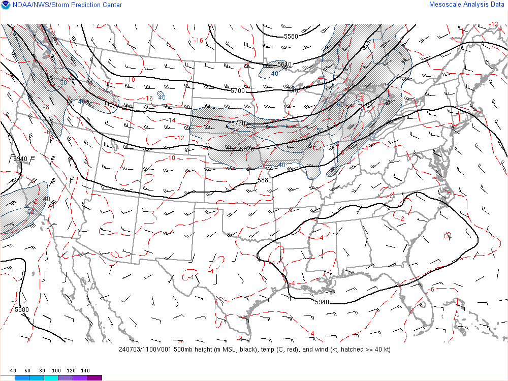
This is not the sexiest 500mb look I've seen. There's been...better. There is not much amplification. The PNA is not extremely positive. The trough is not full latitude. But we can work with this. There is very strong PVA, or upper air vorticity, at the base of this trough. The 500mb closed low - which is clearly visible over the Great Lakes - will aid in swinging this energy across the Mid-Atlantic states then eventually off our coast where another 500mb low is expected to develop. These 2 500mb low will work in tandem to bring about another strong coastal storm. The path in which the mid-level lows take, namely 500mb and 700mb lows, will be critical to the entire forecast.

Example: the 00z NAM released just a few moments ago tracked the 500mb low east of where 18z NAM had it. This is a huge east shift that occurred in such a small 6 hour window. As a result, the storm is colder and higher snowfall amounts are seen into NYC. The 700mb is still very close to the coast, which may bring about a dry slow near NYC, but that is also still trending.
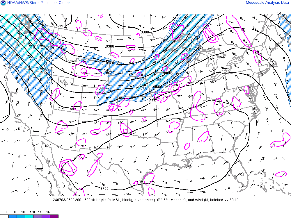
A 150kt upper level jet streak is undercutting this system. This jet streak will expand northward and really help bring about some incredible dynamics. Some of the short-range models are spitting out 4-5"/hour snowfall rates. I truly think someone in north-central NJ, NW NJ, eastern PA (including NEPA), or SW NY is going to approach the 20" mark. 700mb VV's and some of the instability levels the soundings are showing suggest such rates are likely.

850mb/925mb temps are cold to support snow. That said during the day tomorrow, mainly along the coast, some of the precip is likely to fall as rain because of the 500/700mb low tracks. It could keep winds easterly which would aid in air temps, or surface temps, staying above freezing. One way to overcome that is with heavy precipitation rates. And since some of the models are showing that I am confident there will be more moments than not where a heavy wet snow is falling as opposed to rain.
And with that being said, please do not take this storm lightly whether you live near or away from the coast. Near the coast, you will deal with the heavy wet snow and some gusty winds. This will cause power outages. Away from the coast you may still be without power while having to deal with 12-18 inches of a heavy snow. That can't be fun.
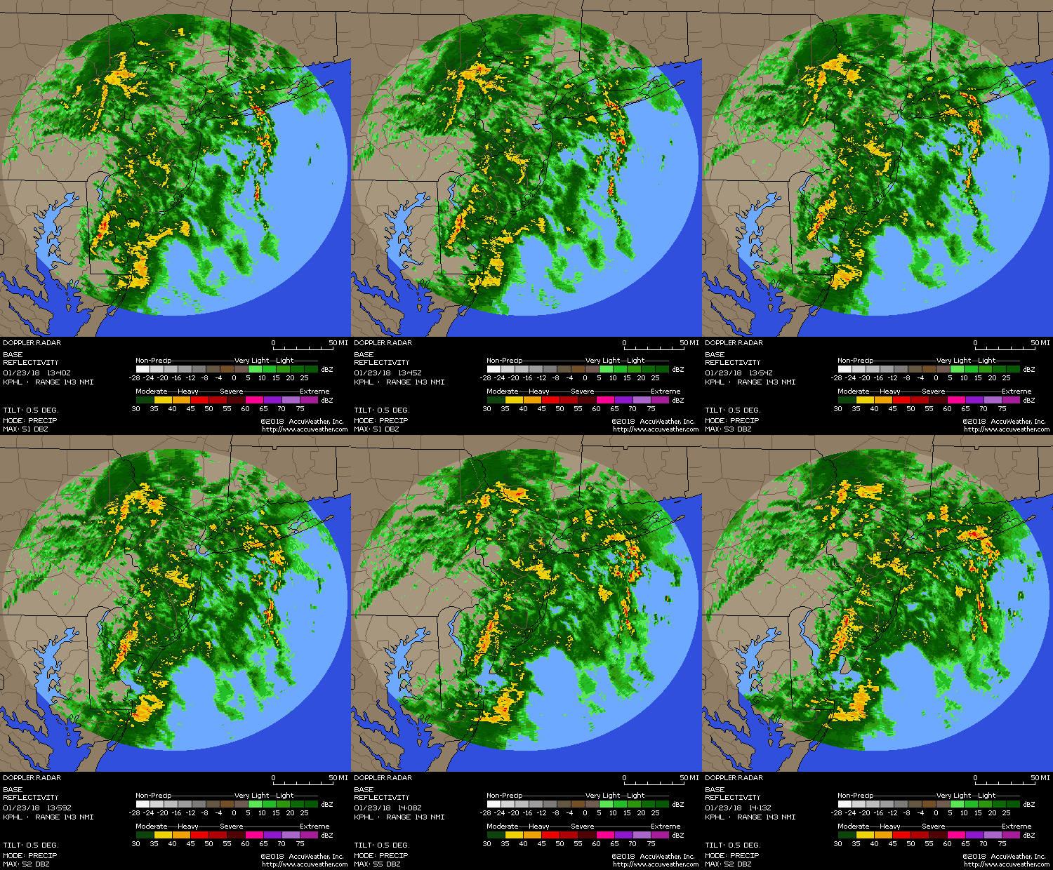

Plume of moisture is working its way up the coast. A nice little overrunning event before the main show. The secondary low should develop near the Delmarva between 4-5am and work up the coast from there. But right ON or just OFF the coast? That is the million-dollar question. It may start along the coast then suddenly take a turn ENE. Who the hell knows. Key is to follow your mid-level lows tomorrow.
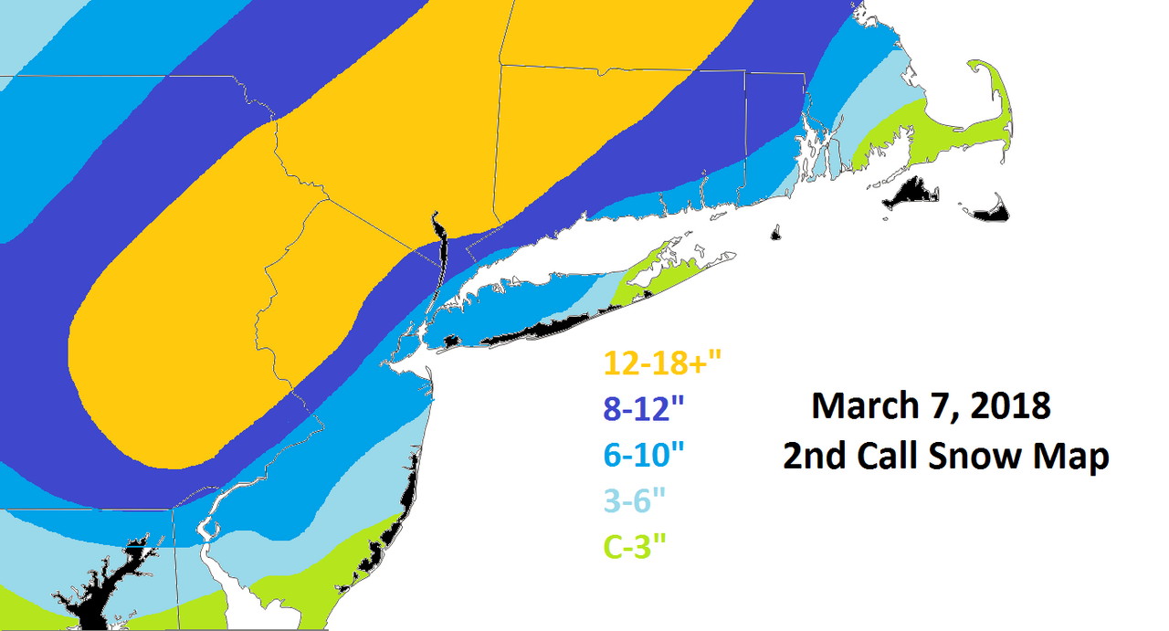
This was my 2nd call snow map but I've decided to make it my final. However, if I had the energy to create a new one I would be inclined to move the dark blue shade of 8-12" into NE NJ, NYC, and small section of WLI. I am a believer in the latest tends we are seeing (18z GFS jogged east, 00z NAM jogged east, RGEM the most consistent model of this storm). Heck, even those amounts could be underdone for parts of the area. But I am being mindful of the 700mb low (unfavorable track and winds) and March climo.
Love you all.
Ciao,
Francesco

This is not the sexiest 500mb look I've seen. There's been...better. There is not much amplification. The PNA is not extremely positive. The trough is not full latitude. But we can work with this. There is very strong PVA, or upper air vorticity, at the base of this trough. The 500mb closed low - which is clearly visible over the Great Lakes - will aid in swinging this energy across the Mid-Atlantic states then eventually off our coast where another 500mb low is expected to develop. These 2 500mb low will work in tandem to bring about another strong coastal storm. The path in which the mid-level lows take, namely 500mb and 700mb lows, will be critical to the entire forecast.

Example: the 00z NAM released just a few moments ago tracked the 500mb low east of where 18z NAM had it. This is a huge east shift that occurred in such a small 6 hour window. As a result, the storm is colder and higher snowfall amounts are seen into NYC. The 700mb is still very close to the coast, which may bring about a dry slow near NYC, but that is also still trending.

A 150kt upper level jet streak is undercutting this system. This jet streak will expand northward and really help bring about some incredible dynamics. Some of the short-range models are spitting out 4-5"/hour snowfall rates. I truly think someone in north-central NJ, NW NJ, eastern PA (including NEPA), or SW NY is going to approach the 20" mark. 700mb VV's and some of the instability levels the soundings are showing suggest such rates are likely.

850mb/925mb temps are cold to support snow. That said during the day tomorrow, mainly along the coast, some of the precip is likely to fall as rain because of the 500/700mb low tracks. It could keep winds easterly which would aid in air temps, or surface temps, staying above freezing. One way to overcome that is with heavy precipitation rates. And since some of the models are showing that I am confident there will be more moments than not where a heavy wet snow is falling as opposed to rain.
And with that being said, please do not take this storm lightly whether you live near or away from the coast. Near the coast, you will deal with the heavy wet snow and some gusty winds. This will cause power outages. Away from the coast you may still be without power while having to deal with 12-18 inches of a heavy snow. That can't be fun.


Plume of moisture is working its way up the coast. A nice little overrunning event before the main show. The secondary low should develop near the Delmarva between 4-5am and work up the coast from there. But right ON or just OFF the coast? That is the million-dollar question. It may start along the coast then suddenly take a turn ENE. Who the hell knows. Key is to follow your mid-level lows tomorrow.

This was my 2nd call snow map but I've decided to make it my final. However, if I had the energy to create a new one I would be inclined to move the dark blue shade of 8-12" into NE NJ, NYC, and small section of WLI. I am a believer in the latest tends we are seeing (18z GFS jogged east, 00z NAM jogged east, RGEM the most consistent model of this storm). Heck, even those amounts could be underdone for parts of the area. But I am being mindful of the 700mb low (unfavorable track and winds) and March climo.
Love you all.
Ciao,
Francesco
_________________
_______________________________________________________________________________________________________
CLICK HERE to view NJ Strong Snowstorm Classifications
 Re: Pain in the Butt March 7th Godzilla: Observations
Great analysis frank! Radar is blossoming already and precip is rapidly moving in. Going to be a fun storm!
_________________
-Alex Iannone-

aiannone- Senior Enthusiast - Mod

- Posts : 4815
Reputation : 92
Join date : 2013-01-07
Location : Saint James, LI (Northwest Suffolk Co.)
 Re: Pain in the Butt March 7th Godzilla: Observations
GFS got all 10 recon drops...woah
SENIOR DUTY METEOROLOGIST NWS ADMINISTRATIVE MESSAGE
NWS NCEP CENTRAL OPERATIONS COLLEGE PARK MD
0301Z WED MAR 07 2018
The 00Z GFS has started and is running on time. In addition to
the usual complement of raobs...10 dropsondes were available
courtesy of a USAF winter storm reconnaissance flight.
Handel/SDM/NCO/NCEP
_________________
_______________________________________________________________________________________________________
CLICK HERE to view NJ Strong Snowstorm Classifications
 Re: Pain in the Butt March 7th Godzilla: Observations
RPM


_________________
_______________________________________________________________________________________________________
CLICK HERE to view NJ Strong Snowstorm Classifications
 Re: Pain in the Butt March 7th Godzilla: Observations
00z Canadian. Obliterated.


_________________
_______________________________________________________________________________________________________
CLICK HERE to view NJ Strong Snowstorm Classifications
 Re: Pain in the Butt March 7th Godzilla: Observations
Frank_Wx wrote:GFS got all 10 recon drops...woah
SENIOR DUTY METEOROLOGIST NWS ADMINISTRATIVE MESSAGE
NWS NCEP CENTRAL OPERATIONS COLLEGE PARK MD
0301Z WED MAR 07 2018
The 00Z GFS has started and is running on time. In addition to
the usual complement of raobs...10 dropsondes were available
courtesy of a USAF winter storm reconnaissance flight.
Handel/SDM/NCO/NCEP
Guess I am out of this...

mikeypizano- Pro Enthusiast

- Posts : 1118
Reputation : 66
Join date : 2017-01-05
Age : 35
Location : Wilkes-Barre/Scranton, PA
 Re: Pain in the Butt March 7th Godzilla: Observations
Frank_Wx wrote:00z Canadian. Obliterated.
Wow and with those rates, I’m sure it would be mostly snow even to the coast
_________________
-Alex Iannone-

aiannone- Senior Enthusiast - Mod

- Posts : 4815
Reputation : 92
Join date : 2013-01-07
Location : Saint James, LI (Northwest Suffolk Co.)
 Re: Pain in the Butt March 7th Godzilla: Observations
He's baaaaack!
https://www.youtube.com/watch?v=ZM8DUWWpIG8&feature=push-u&attr_tag=YERQxDUmJ_Tvr-gN-6
https://www.youtube.com/watch?v=ZM8DUWWpIG8&feature=push-u&attr_tag=YERQxDUmJ_Tvr-gN-6
hurrysundown23- Posts : 53
Reputation : 1
Join date : 2017-01-04
Location : Sayreville, NJ
 Re: Pain in the Butt March 7th Godzilla: Observations
Do we get a white Gold show on the Jersey Shore?
Smittyaj623- Posts : 73
Reputation : 6
Join date : 2018-03-06
Age : 24
Location : Bayville, NJ
 Re: Pain in the Butt March 7th Godzilla: Observations
Wow. And to the post in other thread about Mt Holly and their power outage alert. Upton needs to heed the same I'm. Even frank agrees. Frank dropping the blue into NYC would that put southern wc in the 12 to 18 or no? But u did say to these totals are not possible. Exciting day coming up! NYC u need to close schools!

jmanley32- Senior Enthusiast

- Posts : 20535
Reputation : 108
Join date : 2013-12-12
Age : 43
Location : Yonkers, NY
 Re: Pain in the Butt March 7th Godzilla: Observations
holy smokes!! NYC jackpot again!aiannone wrote:Frank_Wx wrote:00z Canadian. Obliterated.
Wow and with those rates, I’m sure it would be mostly snow even to the coast

jmanley32- Senior Enthusiast

- Posts : 20535
Reputation : 108
Join date : 2013-12-12
Age : 43
Location : Yonkers, NY
 Re: Pain in the Butt March 7th Godzilla: Observations
Thanks Frank Great job Terrific
oldtimer- Senior Enthusiast

- Posts : 1103
Reputation : 14
Join date : 2013-01-16
Age : 78
Location : Port Jefferson Station Suffolk County

aiannone- Senior Enthusiast - Mod

- Posts : 4815
Reputation : 92
Join date : 2013-01-07
Location : Saint James, LI (Northwest Suffolk Co.)
 Re: Pain in the Butt March 7th Godzilla: Observations
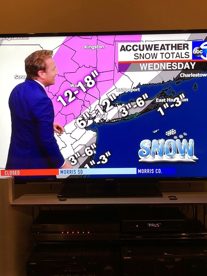
Heard Lee Goldberg, my fav TV MET, introduced 12-18" of snow to parts of NNJ in his latest snow map. Anyone have a picture?
_________________
_______________________________________________________________________________________________________
CLICK HERE to view NJ Strong Snowstorm Classifications
 Re: Pain in the Butt March 7th Godzilla: Observations
so correct me if I’m wrong. EVERY MODEL TONIGHT WENT EAST AND SOUTH THUS COLDER? If this is the case I think the double digit totals approach the Jersey coast and at least the western half of LI
Guest- Guest
 Re: Pain in the Butt March 7th Godzilla: Observations
Dew point 32* here temp 38*. Presently 34* and snowing in DC. Once precip gets going here temps should drop to near freezing.

billg315- Advanced Forecaster - Mod

- Posts : 4483
Reputation : 185
Join date : 2015-01-24
Age : 50
Location : Flemington, NJ
 Re: Pain in the Butt March 7th Godzilla: Observations
Hurry - if there was a weather sci fi horror movie , that dude from the utube video would be the lead character , haha, what a nightmare 

WeatherBob- Meteorologist

- Posts : 683
Reputation : 83
Join date : 2013-12-13
Location : Caldwell, NJ - NW Essex County - Altitude 500 FT
 Re: Pain in the Butt March 7th Godzilla: Observations
Frank_Wx wrote:Heard Lee Goldberg, my fav TV MET, introduced 12-18" of snow to parts of NNJ in his latest snow map. Anyone have a picture?
He said the SE colder scenario is becoming more likely.
_________________
-Alex Iannone-

aiannone- Senior Enthusiast - Mod

- Posts : 4815
Reputation : 92
Join date : 2013-01-07
Location : Saint James, LI (Northwest Suffolk Co.)
 Re: Pain in the Butt March 7th Godzilla: Observations
WeatherBob wrote:Hurry - if there was a weather sci fi horror movie , that dude from the utube video would be the lead character , haha, what a nightmare
I love the Godzooky avatar
Guest- Guest
 Re: Pain in the Butt March 7th Godzilla: Observations
syosnow94 wrote:so correct me if I’m wrong. EVERY MODEL TONIGHT WENT EAST AND SOUTH THUS COLDER? If this is the case I think the double digit totals approach the Jersey coast and at least the western half of LI
Thought I was not seeing you until next winter. Glad you stuck around, guy.
billg315 wrote:Dew point 32* here temp 38*. Presently 34* and snowing in DC. Once precip gets going here temps should drop to near freezing.
Parts of DC is over-performing in the snow department. An indication over-performance is coming here? Stay tuned...
WeatherBob wrote:Hurry - if there was a weather sci fi horror movie , that dude from the utube video would be the lead character , haha, what a nightmare
Funny
_________________
_______________________________________________________________________________________________________
CLICK HERE to view NJ Strong Snowstorm Classifications
 Re: Pain in the Butt March 7th Godzilla: Observations
aiannone wrote:Frank_Wx wrote:Heard Lee Goldberg, my fav TV MET, introduced 12-18" of snow to parts of NNJ in his latest snow map. Anyone have a picture?
He said the SE colder scenario is becoming more likely.

Guest- Guest
 Re: Pain in the Butt March 7th Godzilla: Observations
You’re killing me with the guy stuff man
Guest- Guest
 Re: Pain in the Butt March 7th Godzilla: Observations
aiannone wrote:Frank_Wx wrote:Heard Lee Goldberg, my fav TV MET, introduced 12-18" of snow to parts of NNJ in his latest snow map. Anyone have a picture?
He said the SE colder scenario is becoming more likely.
A replica of my map but I have an 8-12 and 6-10 zone where he has a general 6-12 which I feel is too "broad" a scale. But for some reason I see 6-12 used by a lot of mets and enthusiasts.
_________________
_______________________________________________________________________________________________________
CLICK HERE to view NJ Strong Snowstorm Classifications
 Re: Pain in the Butt March 7th Godzilla: Observations
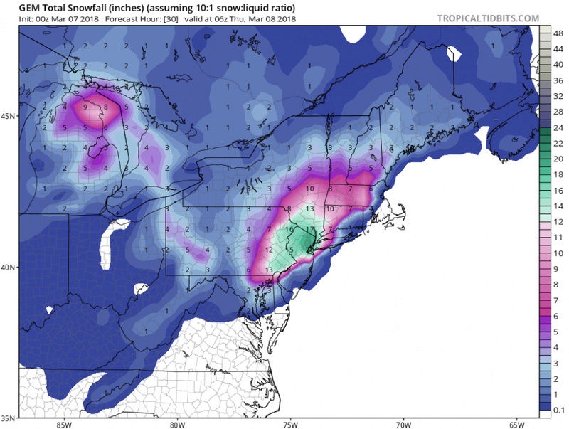
NYC pretty much ground zero on the GEM. Not sure I buy it with temps around 34 and most of the precip during the day but even at half the totals still a good storm for them


CPcantmeasuresnow- Wx Statistician Guru

- Posts : 7274
Reputation : 230
Join date : 2013-01-07
Age : 103
Location : Eastern Orange County, NY
 Re: Pain in the Butt March 7th Godzilla: Observations
Wow cmc gfs both agree nam 3km rgem all agree on placement and totals but I think NYC needs b increased a lot and surround areas personally. Frank how concerned are u about outages down here? Widespread or sporadic? News is all over about the power even moreso than the snow.

jmanley32- Senior Enthusiast

- Posts : 20535
Reputation : 108
Join date : 2013-12-12
Age : 43
Location : Yonkers, NY
Page 1 of 42 • 1, 2, 3 ... 21 ... 42 
Page 1 of 42
Permissions in this forum:
You cannot reply to topics in this forum
 Home
Home