
 Search
March Madness! Spring Snowstorm Observations
Page 1 of 40 • 1, 2, 3 ... 20 ... 40 ![]()

March Madness! Spring Snowstorm Observations
![]() by Frank_Wx Tue Mar 20, 2018 8:09 am
by Frank_Wx Tue Mar 20, 2018 8:09 am
GFS

NAM

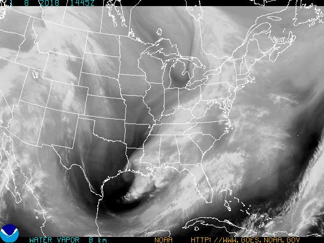
The trough is neutral and heights are closer to the coast on the GFS compared to the NAM. This is why the low on the NAM deepens but ends up tracking more east than northeast. This SLIGHT variance is the difference between 12"+ of snow or 6"+ of snow for many areas. The 00z NAM last night was a solid hit for the area (looked like other models) but reverted back to this more east solution early this morning at its 06z run. At this point, the NAM is not just inconsistent but also on its own. The EURO, RGEM, SREFS and others are more in line with the GFS and the GEFS (GEFS more bullish than the GFS OP which also says something).
The EURO OP and the GFS OP are actually fairly close. I actually think after today's 12z runs we will see agreement between these 2 models in terms of track of the SLP, then we can use meso-scale models to determine where the CCB sets up and where the best snowfall rates will be. I think an area-wide Mothrazilla is a lock with a Godzilla being VERY close to happening. We will see at 12z today which way models lean. Do they stay near the coast and deliver a Godzilla, or do they get pulled slightly east to give everyone a Mothrazilla while also removing sleet and rain from the equation for coastal areas. We'll find out very soon.
I will have a final call snow map later today.
_________________
_______________________________________________________________________________________________________
CLICK HERE to view NJ Strong Snowstorm Classifications

Frank_Wx- Godzilla Seeker

- Posts : 21305
Reputation : 328
Join date : 2013-01-05
Age : 32
Location : Jersey City, NJ -

Re: March Madness! Spring Snowstorm Observations
![]() by Frank_Wx Tue Mar 20, 2018 8:10 am
by Frank_Wx Tue Mar 20, 2018 8:10 am

_________________
_______________________________________________________________________________________________________
CLICK HERE to view NJ Strong Snowstorm Classifications
Frank_Wx- Godzilla Seeker
- Posts : 21305
Reputation : 328
Join date : 2013-01-05
Age : 32
Location : Jersey City, NJ -
Re: March Madness! Spring Snowstorm Observations
![]() by Frank_Wx Tue Mar 20, 2018 8:12 am
by Frank_Wx Tue Mar 20, 2018 8:12 am

_________________
_______________________________________________________________________________________________________
CLICK HERE to view NJ Strong Snowstorm Classifications
Frank_Wx- Godzilla Seeker
- Posts : 21305
Reputation : 328
Join date : 2013-01-05
Age : 32
Location : Jersey City, NJ -
Re: March Madness! Spring Snowstorm Observations
![]() by Sanchize06 Tue Mar 20, 2018 8:13 am
by Sanchize06 Tue Mar 20, 2018 8:13 am
Sanchize06- Senior Enthusiast

- Posts : 1041
Reputation : 21
Join date : 2013-02-05
Location : Union Beach, NJ
Re: March Madness! Spring Snowstorm Observations
![]() by Frank_Wx Tue Mar 20, 2018 8:15 am
by Frank_Wx Tue Mar 20, 2018 8:15 am

.thumb.gif.c1ea1f8c701d2775d3d242c98ed5f41e.gif)
_________________
_______________________________________________________________________________________________________
CLICK HERE to view NJ Strong Snowstorm Classifications
Frank_Wx- Godzilla Seeker
- Posts : 21305
Reputation : 328
Join date : 2013-01-05
Age : 32
Location : Jersey City, NJ -
Re: March Madness! Spring Snowstorm Observations
![]() by Frank_Wx Tue Mar 20, 2018 8:16 am
by Frank_Wx Tue Mar 20, 2018 8:16 am
.thumb.gif.a30f66de2c527a0185f8ebc5ce3e50fa.gif)
_________________
_______________________________________________________________________________________________________
CLICK HERE to view NJ Strong Snowstorm Classifications
Frank_Wx- Godzilla Seeker
- Posts : 21305
Reputation : 328
Join date : 2013-01-05
Age : 32
Location : Jersey City, NJ -
Re: March Madness! Spring Snowstorm Observations
![]() by Frank_Wx Tue Mar 20, 2018 8:18 am
by Frank_Wx Tue Mar 20, 2018 8:18 am

_________________
_______________________________________________________________________________________________________
CLICK HERE to view NJ Strong Snowstorm Classifications
Frank_Wx- Godzilla Seeker
- Posts : 21305
Reputation : 328
Join date : 2013-01-05
Age : 32
Location : Jersey City, NJ -
Re: March Madness! Spring Snowstorm Observations
![]() by SoulSingMG Tue Mar 20, 2018 8:20 am
by SoulSingMG Tue Mar 20, 2018 8:20 am


SoulSingMG- Senior Enthusiast
- Posts : 2853
Reputation : 74
Join date : 2013-12-11
Location : Long Island City, NY
Re: March Madness! Spring Snowstorm Observations
![]() by CPcantmeasuresnow Tue Mar 20, 2018 8:22 am
by CPcantmeasuresnow Tue Mar 20, 2018 8:22 am
Frank_Wx wrote:If the tick east is real - and I have a feeling it might be because of the "push" of the confluence to the north - then there will be a sharp cut-off for areas like NEPA, NW NJ, and N of NYC.
That seems to be pretty consistent on most models since last night. Once the storm gets to about the Maryland PA border latitude it hits a wall and goes mostly due east, then ENE. The TZ bridge seems to be the N/S border from there to 30 miles north where there will be a sharp cutoff somewhere in that 30 mile range.

CPcantmeasuresnow- Wx Statistician Guru

- Posts : 7274
Reputation : 230
Join date : 2013-01-07
Age : 103
Location : Eastern Orange County, NY
SoulSingMG- Senior Enthusiast
- Posts : 2853
Reputation : 74
Join date : 2013-12-11
Location : Long Island City, NY
Re: March Madness! Spring Snowstorm Observations
![]() by Guest Tue Mar 20, 2018 8:24 am
by Guest Tue Mar 20, 2018 8:24 am
SoulSingMG wrote:This is insane, all due respect. No reliable guidance supports these agressive numbers. NWS struggling this season for sure. Not sure what's up. We'll see if their 4pm has drastic cuts if this east trend continues (as they usually change snow maps minute to minute lol)
Totally agree Soul. I think 8-12” area wide from eastern NJ east. 4-8 NYC on West and North
Guest- Guest
Re: March Madness! Spring Snowstorm Observations
![]() by Frank_Wx Tue Mar 20, 2018 8:24 am
by Frank_Wx Tue Mar 20, 2018 8:24 am
SoulSingMG wrote:This is insane, all due respect. No reliable guidance supports these agressive numbers. NWS struggling this season for sure. Not sure what's up. We'll see if their 4pm has drastic cuts if this east trend continues (as they usually change snow maps minute to minute lol)
They are forecasting an area-wide Godzilla.
That is still on the table but I am thinking area-wide Mothrazilla with isolated towns receiving 12"+ depending where the CCB or heavier snow rates form. Big 12z runs today. If models tuck the low into the coast like EURO showed yesterday then that will result in Godzilla snowfall amounts. We need H5 to close off fast which allows heights to amplify along the east coast.
_________________
_______________________________________________________________________________________________________
CLICK HERE to view NJ Strong Snowstorm Classifications
Frank_Wx- Godzilla Seeker
- Posts : 21305
Reputation : 328
Join date : 2013-01-05
Age : 32
Location : Jersey City, NJ -
Re: March Madness! Spring Snowstorm Observations
![]() by SoulSingMG Tue Mar 20, 2018 8:25 am
by SoulSingMG Tue Mar 20, 2018 8:25 am

SoulSingMG- Senior Enthusiast
- Posts : 2853
Reputation : 74
Join date : 2013-12-11
Location : Long Island City, NY
Re: March Madness! Spring Snowstorm Observations
![]() by Frank_Wx Tue Mar 20, 2018 8:26 am
by Frank_Wx Tue Mar 20, 2018 8:26 am


_________________
_______________________________________________________________________________________________________
CLICK HERE to view NJ Strong Snowstorm Classifications
Frank_Wx- Godzilla Seeker
- Posts : 21305
Reputation : 328
Join date : 2013-01-05
Age : 32
Location : Jersey City, NJ -
Re: March Madness! Spring Snowstorm Observations
![]() by weatherwatchermom Tue Mar 20, 2018 8:41 am
by weatherwatchermom Tue Mar 20, 2018 8:41 am
SoulSingMG wrote:EXTREME?? Bullish, imo. (Thx @weatherwilly for map)
wow

weatherwatchermom- Senior Enthusiast
- Posts : 3793
Reputation : 78
Join date : 2014-11-25
Location : Hazlet Township, NJ
Re: March Madness! Spring Snowstorm Observations
![]() by Frank_Wx Tue Mar 20, 2018 8:44 am
by Frank_Wx Tue Mar 20, 2018 8:44 am

_________________
_______________________________________________________________________________________________________
CLICK HERE to view NJ Strong Snowstorm Classifications
Frank_Wx- Godzilla Seeker
- Posts : 21305
Reputation : 328
Join date : 2013-01-05
Age : 32
Location : Jersey City, NJ -
Re: March Madness! Spring Snowstorm Observations
![]() by Guest Tue Mar 20, 2018 8:44 am
by Guest Tue Mar 20, 2018 8:44 am
Guest- Guest
Re: March Madness! Spring Snowstorm Observations
![]() by Frank_Wx Tue Mar 20, 2018 8:46 am
by Frank_Wx Tue Mar 20, 2018 8:46 am

_________________
_______________________________________________________________________________________________________
CLICK HERE to view NJ Strong Snowstorm Classifications
Frank_Wx- Godzilla Seeker
- Posts : 21305
Reputation : 328
Join date : 2013-01-05
Age : 32
Location : Jersey City, NJ -
Re: March Madness! Spring Snowstorm Observations
![]() by jmanley32 Tue Mar 20, 2018 8:47 am
by jmanley32 Tue Mar 20, 2018 8:47 am
wow 24 for me! What model is that?Frank_Wx wrote:If the tick east is real - and I have a feeling it might be because of the "push" of the confluence to the north - then there will be a sharp cut-off for areas like NEPA, NW NJ, and N of NYC.

jmanley32- Senior Enthusiast
- Posts : 20535
Reputation : 108
Join date : 2013-12-12
Age : 43
Location : Yonkers, NY
Re: March Madness! Spring Snowstorm Observations
![]() by SoulSingMG Tue Mar 20, 2018 8:50 am
by SoulSingMG Tue Mar 20, 2018 8:50 am
jmanley32 wrote:wow 24 for me! What model is that?Frank_Wx wrote:If the tick east is real - and I have a feeling it might be because of the "push" of the confluence to the north - then there will be a sharp cut-off for areas like NEPA, NW NJ, and N of NYC.
DEEP THUNDER
SoulSingMG- Senior Enthusiast
- Posts : 2853
Reputation : 74
Join date : 2013-12-11
Location : Long Island City, NY
Re: March Madness! Spring Snowstorm Observations
![]() by Taffy Tue Mar 20, 2018 8:52 am
by Taffy Tue Mar 20, 2018 8:52 am

Taffy- Pro Enthusiast

- Posts : 530
Reputation : 19
Join date : 2013-10-06
Location : Hopkinton, MA
Re: March Madness! Spring Snowstorm Observations
![]() by billg315 Tue Mar 20, 2018 9:02 am
by billg315 Tue Mar 20, 2018 9:02 am

billg315- Advanced Forecaster - Mod

- Posts : 4483
Reputation : 185
Join date : 2015-01-24
Age : 50
Location : Flemington, NJ
Re: March Madness! Spring Snowstorm Observations
![]() by amugs Tue Mar 20, 2018 9:03 am
by amugs Tue Mar 20, 2018 9:03 am
jmanley32 wrote:wow 24 for me! What model is that?Frank_Wx wrote:If the tick east is real - and I have a feeling it might be because of the "push" of the confluence to the north - then there will be a sharp cut-off for areas like NEPA, NW NJ, and N of NYC.
This is the GEM LAM which is in MM for qpf
24 MM = .98 inches of Liquid (QPF)
_________________
Mugs
AKA:King: Snow Weenie
Self Proclaimed
WINTER 2014-15 : 55.12" +.02 for 6 coatings (avg. 35")
WINTER 2015-16 Total - 29.8" (Avg 35")
WINTER 2016-17 : 39.5" so far

amugs- Advanced Forecaster - Mod
- Posts : 15095
Reputation : 213
Join date : 2013-01-07
Age : 54
Location : Hillsdale,NJ
Re: March Madness! Spring Snowstorm Observations
![]() by Frank_Wx Tue Mar 20, 2018 9:11 am
by Frank_Wx Tue Mar 20, 2018 9:11 am
_________________
_______________________________________________________________________________________________________
CLICK HERE to view NJ Strong Snowstorm Classifications
Frank_Wx- Godzilla Seeker
- Posts : 21305
Reputation : 328
Join date : 2013-01-05
Age : 32
Location : Jersey City, NJ -
Re: March Madness! Spring Snowstorm Observations
![]() by amugs Tue Mar 20, 2018 9:11 am
by amugs Tue Mar 20, 2018 9:11 am

WPC much more conservative
.png.67a934b11abd7f4b1476f4af53e44d0c.png)
ARW which have not wavered with this storm

From a couple for pro mets - 6Z NAM was a burp adn needs to be tossed for it SLP depiction. That should ease some of the panic in here
_________________
Mugs
AKA:King: Snow Weenie
Self Proclaimed
WINTER 2014-15 : 55.12" +.02 for 6 coatings (avg. 35")
WINTER 2015-16 Total - 29.8" (Avg 35")
WINTER 2016-17 : 39.5" so far
amugs- Advanced Forecaster - Mod
- Posts : 15095
Reputation : 213
Join date : 2013-01-07
Age : 54
Location : Hillsdale,NJ
Page 1 of 40 • 1, 2, 3 ... 20 ... 40 ![]()
|
|
|