
 Search
March Madness! Spring Snowstorm Observations
Page 9 of 40 •  1 ... 6 ... 8, 9, 10 ... 24 ... 40
 ![]()
Re: March Madness! Spring Snowstorm Observations
![]() by Frank_Wx Tue Mar 20, 2018 3:04 pm
by Frank_Wx Tue Mar 20, 2018 3:04 pm
Frank_Wx- Godzilla Seeker

- Posts : 21305
Join date : 2013-01-05 -

Re: March Madness! Spring Snowstorm Observations
![]() by Frank_Wx Tue Mar 20, 2018 3:05 pm
by Frank_Wx Tue Mar 20, 2018 3:05 pm
Frank_Wx- Godzilla Seeker
- Posts : 21305
Join date : 2013-01-05 -
Re: March Madness! Spring Snowstorm Observations
![]() by billg315 Tue Mar 20, 2018 3:05 pm
by billg315 Tue Mar 20, 2018 3:05 pm
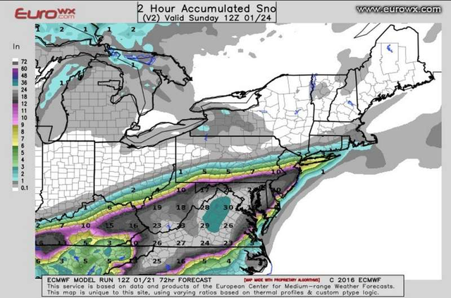
If we're talking about sharp cutoffs to the N&W I think that is real and the Euro and NAM are sniffing that out to varying degrees. But that doesn't mean the Euro's placement of that cutoff is 100 percent accurate. Especially when other models have it well north and west of there. Still a lot of wobbling with that to go on between now and late tomorrow morning when this kicks into high gear.

billg315- Advanced Forecaster - Mod

- Posts : 4462
Reputation : 185
Join date : 2015-01-24
Age : 50
Location : Flemington, NJ
Re: March Madness! Spring Snowstorm Observations
![]() by Guest Tue Mar 20, 2018 3:06 pm
by Guest Tue Mar 20, 2018 3:06 pm
Frank_Wx wrote:The GFS H5 is just as south (maybe even more east) than the EURO but it still has good snow extending north.

Is this an uh oh moment?
I thought globale were pretty useless inside this range
Guest- Guest
Re: March Madness! Spring Snowstorm Observations
![]() by billg315 Tue Mar 20, 2018 3:07 pm
by billg315 Tue Mar 20, 2018 3:07 pm
Frank_Wx wrote:EURO is not what it used to be. Very curious to see what EPS show.
Thank you. I mean I wouldn't write it off, it has value to look at. But it seems like forever since it was "King Euro." Three years maybe. It seems like nobody has given it much weight in the last year or so, or as much as it used to get.
billg315- Advanced Forecaster - Mod
- Posts : 4462
Reputation : 185
Join date : 2015-01-24
Age : 50
Location : Flemington, NJ
Re: March Madness! Spring Snowstorm Observations
![]() by Carter bk Tue Mar 20, 2018 3:10 pm
by Carter bk Tue Mar 20, 2018 3:10 pm
Carter bk- Posts : 73
Reputation : 5
Join date : 2017-12-07
Re: March Madness! Spring Snowstorm Observations
![]() by Frank_Wx Tue Mar 20, 2018 3:10 pm
by Frank_Wx Tue Mar 20, 2018 3:10 pm
That said, I am confident in my map and remain hopeful the meso-models have the best handle on this storm at the moment due to the dynamics involved.

_________________
_______________________________________________________________________________________________________
CLICK HERE to view NJ Strong Snowstorm Classifications

Frank_Wx- Godzilla Seeker
- Posts : 21305
Reputation : 328
Join date : 2013-01-05
Age : 31
Location : Jersey City, NJ -
Re: March Madness! Spring Snowstorm Observations
![]() by sroc4 Tue Mar 20, 2018 3:10 pm
by sroc4 Tue Mar 20, 2018 3:10 pm
syosnow94 wrote:Frank_Wx wrote:The GFS H5 is just as south (maybe even more east) than the EURO but it still has good snow extending north.
Is this an uh oh moment?
I thought globale were pretty useless inside this range
GFS and pretty much all other models have bands of vorticity on the NW flank of the closed H5 low; whereas the Euro did not..see image in my last post. I'm not sure I trust the euro that that is as far as the precip gets based on this info. Its a deepening ULL as it passes S of LI so the deform bands form around the cyclonic curvature. For some reason the euro simply cuts off the vorticity along this curvature. I'm not buying it yet, but if the ULL cwinds up even further S&W then what is modeled then def N&W needs to worry.

_________________
"In weather and in life, there's no winning and losing; there's only winning and learning."
WINTER 2012/2013 TOTALS 43.65"WINTER 2017/2018 TOTALS 62.85" WINTER 2022/2023 TOTALS 4.9"
WINTER 2013/2014 TOTALS 64.85"WINTER 2018/2019 TOTALS 14.25" WINTER 2023/2024 TOTALS 13.1"
WINTER 2014/2015 TOTALS 71.20"WINTER 2019/2020 TOTALS 6.35"
WINTER 2015/2016 TOTALS 35.00"WINTER 2020/2021 TOTALS 37.75"
WINTER 2016/2017 TOTALS 42.25"WINTER 2021/2022 TOTALS 31.65"

sroc4- Admin
- Posts : 8331
Reputation : 301
Join date : 2013-01-07
Location : Wading River, LI
Re: March Madness! Spring Snowstorm Observations
![]() by Frank_Wx Tue Mar 20, 2018 3:11 pm
by Frank_Wx Tue Mar 20, 2018 3:11 pm

_________________
_______________________________________________________________________________________________________
CLICK HERE to view NJ Strong Snowstorm Classifications
Frank_Wx- Godzilla Seeker
- Posts : 21305
Reputation : 328
Join date : 2013-01-05
Age : 31
Location : Jersey City, NJ -
Re: March Madness! Spring Snowstorm Observations
![]() by CPcantmeasuresnow Tue Mar 20, 2018 3:12 pm
by CPcantmeasuresnow Tue Mar 20, 2018 3:12 pm
It was getting to the point with this storm where if you ended up getting 6-8 inches out of it you felt like you were robbed at gunpoint.

CPcantmeasuresnow- Wx Statistician Guru

- Posts : 7274
Reputation : 230
Join date : 2013-01-07
Age : 103
Location : Eastern Orange County, NY
Re: March Madness! Spring Snowstorm Observations
![]() by sroc4 Tue Mar 20, 2018 3:12 pm
by sroc4 Tue Mar 20, 2018 3:12 pm
sroc4 wrote:syosnow94 wrote:Frank_Wx wrote:The GFS H5 is just as south (maybe even more east) than the EURO but it still has good snow extending north.
Is this an uh oh moment?
I thought globale were pretty useless inside this range
GFS and pretty much all other models have bands of vorticity on the NW flank of the closed H5 low; whereas the Euro did not..see image in my last post. I'm not sure I trust the euro that that is as far as the precip gets based on this info. Its a deepening ULL as it passes S of LI so the deform bands form around the cyclonic curvature. For some reason the euro simply cuts off the vorticity along this curvature. I'm not buying it yet, but if the ULL cwinds up even further S&W then what is modeled then def N&W needs to worry.

_________________
"In weather and in life, there's no winning and losing; there's only winning and learning."
WINTER 2012/2013 TOTALS 43.65"WINTER 2017/2018 TOTALS 62.85" WINTER 2022/2023 TOTALS 4.9"
WINTER 2013/2014 TOTALS 64.85"WINTER 2018/2019 TOTALS 14.25" WINTER 2023/2024 TOTALS 13.1"
WINTER 2014/2015 TOTALS 71.20"WINTER 2019/2020 TOTALS 6.35"
WINTER 2015/2016 TOTALS 35.00"WINTER 2020/2021 TOTALS 37.75"
WINTER 2016/2017 TOTALS 42.25"WINTER 2021/2022 TOTALS 31.65"
sroc4- Admin
- Posts : 8331
Reputation : 301
Join date : 2013-01-07
Location : Wading River, LI
Re: March Madness! Spring Snowstorm Observations
![]() by nutleyblizzard Tue Mar 20, 2018 3:12 pm
by nutleyblizzard Tue Mar 20, 2018 3:12 pm
It would be a heck of a win by the EURO if its correct and all the other models are wrong considering how bad its been this year. My thinking is its just an off run but who knows? Since the storm is now under 24 hours away, it won't be long when we find out.billg315 wrote:Frank_Wx wrote:EURO is not what it used to be. Very curious to see what EPS show.
Thank you. I mean I wouldn't write it off, it has value to look at. But it seems like forever since it was "King Euro." Three years maybe. It seems like nobody has given it much weight in the last year or so, or as much as it used to get.

nutleyblizzard- Senior Enthusiast

- Posts : 1952
Reputation : 41
Join date : 2014-01-30
Age : 58
Location : Nutley, new jersey
Re: March Madness! Spring Snowstorm Observations
![]() by GreyBeard Tue Mar 20, 2018 3:17 pm
by GreyBeard Tue Mar 20, 2018 3:17 pm
GreyBeard- Senior Enthusiast
- Posts : 725
Reputation : 34
Join date : 2014-02-12
Location : eastern nassau county
Re: March Madness! Spring Snowstorm Observations
![]() by Frank_Wx Tue Mar 20, 2018 3:22 pm
by Frank_Wx Tue Mar 20, 2018 3:22 pm
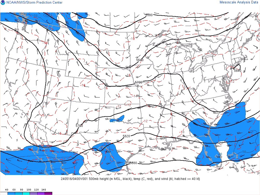
Heights along the EC are beginning to rise as the trough begins to sharpen in response to the phasing of upper energy across the upper Midwest.

12z NAM valid 19z at the 552 DDM height contour south of Cape May, NJ. In the observation above it looks like it's north of Cape May, NJ. Could mean the trough is trying to tilt neutral-negativity sooner.
Keep in mind all these models are adjusting to what is actually happening. When the EURO was running it noticed the higher heights along the EC right away compared to its 00z run last night. They will keep adjusting all day.
_________________
_______________________________________________________________________________________________________
CLICK HERE to view NJ Strong Snowstorm Classifications
Frank_Wx- Godzilla Seeker
- Posts : 21305
Reputation : 328
Join date : 2013-01-05
Age : 31
Location : Jersey City, NJ -
Re: March Madness! Spring Snowstorm Observations
![]() by Frank_Wx Tue Mar 20, 2018 3:24 pm
by Frank_Wx Tue Mar 20, 2018 3:24 pm
GreyBeard wrote:Just took a look at the radar and it is showing precip. all the way up thru long island already but nothing is hitting the ground yet. When does that start happening? I'm at 35° here in eastern Nassau county, but it feels colder. My wunderground weather app says snow showers 'til 8:15.
Not saturated enough. NNJ/NYC likely will not see precip today.

_________________
_______________________________________________________________________________________________________
CLICK HERE to view NJ Strong Snowstorm Classifications
Frank_Wx- Godzilla Seeker
- Posts : 21305
Reputation : 328
Join date : 2013-01-05
Age : 31
Location : Jersey City, NJ -
Re: March Madness! Spring Snowstorm Observations
![]() by richb521 Tue Mar 20, 2018 3:25 pm
by richb521 Tue Mar 20, 2018 3:25 pm
richb521- Posts : 61
Reputation : 3
Join date : 2014-01-19
Age : 49
Location : Hillsborough, NJ
Re: March Madness! Spring Snowstorm Observations
![]() by Frank_Wx Tue Mar 20, 2018 3:27 pm
by Frank_Wx Tue Mar 20, 2018 3:27 pm

_________________
_______________________________________________________________________________________________________
CLICK HERE to view NJ Strong Snowstorm Classifications
Frank_Wx- Godzilla Seeker
- Posts : 21305
Reputation : 328
Join date : 2013-01-05
Age : 31
Location : Jersey City, NJ -
Re: March Madness! Spring Snowstorm Observations
![]() by Frank_Wx Tue Mar 20, 2018 3:28 pm
by Frank_Wx Tue Mar 20, 2018 3:28 pm
_________________
_______________________________________________________________________________________________________
CLICK HERE to view NJ Strong Snowstorm Classifications
Frank_Wx- Godzilla Seeker
- Posts : 21305
Reputation : 328
Join date : 2013-01-05
Age : 31
Location : Jersey City, NJ -
Re: March Madness! Spring Snowstorm Observations
![]() by Frank_Wx Tue Mar 20, 2018 3:29 pm
by Frank_Wx Tue Mar 20, 2018 3:29 pm

_________________
_______________________________________________________________________________________________________
CLICK HERE to view NJ Strong Snowstorm Classifications
Frank_Wx- Godzilla Seeker
- Posts : 21305
Reputation : 328
Join date : 2013-01-05
Age : 31
Location : Jersey City, NJ -
Re: March Madness! Spring Snowstorm Observations
![]() by Frank_Wx Tue Mar 20, 2018 3:30 pm
by Frank_Wx Tue Mar 20, 2018 3:30 pm

_________________
_______________________________________________________________________________________________________
CLICK HERE to view NJ Strong Snowstorm Classifications
Frank_Wx- Godzilla Seeker
- Posts : 21305
Reputation : 328
Join date : 2013-01-05
Age : 31
Location : Jersey City, NJ -
Re: March Madness! Spring Snowstorm Observations
![]() by aiannone Tue Mar 20, 2018 3:31 pm
by aiannone Tue Mar 20, 2018 3:31 pm
Frank_Wx wrote:I HAVE NEVER SEEN THIS BEFORE. THERE IS CFI ON THE EPS. TOSS THE ENTIRE EURO SUITE.
Well that would explain things a bit lol
_________________
-Alex Iannone-

aiannone- Senior Enthusiast - Mod
- Posts : 4813
Reputation : 92
Join date : 2013-01-07
Location : Saint James, LI (Northwest Suffolk Co.)
Re: March Madness! Spring Snowstorm Observations
![]() by Frank_Wx Tue Mar 20, 2018 3:32 pm
by Frank_Wx Tue Mar 20, 2018 3:32 pm

_________________
_______________________________________________________________________________________________________
CLICK HERE to view NJ Strong Snowstorm Classifications
Frank_Wx- Godzilla Seeker
- Posts : 21305
Reputation : 328
Join date : 2013-01-05
Age : 31
Location : Jersey City, NJ -
Re: March Madness! Spring Snowstorm Observations
![]() by dsix85 Tue Mar 20, 2018 3:34 pm
by dsix85 Tue Mar 20, 2018 3:34 pm
dsix85- Pro Enthusiast

- Posts : 349
Reputation : 8
Join date : 2014-01-01
Location : New York
Re: March Madness! Spring Snowstorm Observations
![]() by mmanisca Tue Mar 20, 2018 3:37 pm
by mmanisca Tue Mar 20, 2018 3:37 pm
Northern Fairfield-Northern New Haven-Northern Middlesex-
Southern Fairfield-Southern New Haven-Western Passaic-
Eastern Passaic-Hudson-Western Bergen-Eastern Bergen-
Western Essex-Eastern Essex-Western Union-Eastern Union-Putnam-
Rockland-Northern Westchester-Southern Westchester-
New York (Manhattan)-Bronx-Richmond (Staten Island)-
Kings (Brooklyn)-Northern Queens-Northern Nassau-Southern Queens-
Southern Nassau-
334 PM EDT Tue Mar 20 2018
...WINTER STORM WARNING NOW IN EFFECT FROM 6 AM WEDNESDAY TO 6 AM
EDT THURSDAY...
* WHAT...Heavy snow expected. Total snow accumulations of 11 to
15 inches are expected.
* WHERE...Portions of northeast New Jersey, southern Connecticut
and southeast New York.
* WHEN...From 6 AM Wednesday to 6 AM EDT Thursday.
* ADDITIONAL DETAILS...Travel will be very difficult to
impossible, especially during the evening commute. Snow will
develop during the morning and become heavy by afternoon. Expect
significant reductions in visibility at times. A combination of
the heavy snow and wind gusts up to 35 mph could bring down
tree limbs and power lines, creating power outages.
PRECAUTIONARY/PREPAREDNESS ACTIONS...

mmanisca- Pro Enthusiast
- Posts : 298
Reputation : 3
Join date : 2013-01-23
Age : 65
Location : Deer Park, Long Island
Re: March Madness! Spring Snowstorm Observations
![]() by Aiosamoney21 Tue Mar 20, 2018 3:37 pm
by Aiosamoney21 Tue Mar 20, 2018 3:37 pm
dsix85 wrote:Frank. What does CFI on EPS mean?
i believe it means convective feedback issues
Aiosamoney21- Posts : 86
Reputation : 1
Join date : 2014-02-09
Age : 32
Location : Norwood NJ
Re: March Madness! Spring Snowstorm Observations
![]() by CPcantmeasuresnow Tue Mar 20, 2018 3:37 pm
by CPcantmeasuresnow Tue Mar 20, 2018 3:37 pm
CPcantmeasuresnow- Wx Statistician Guru
- Posts : 7274
Reputation : 230
Join date : 2013-01-07
Age : 103
Location : Eastern Orange County, NY
Re: March Madness! Spring Snowstorm Observations
![]() by bloc1357 Tue Mar 20, 2018 3:37 pm
by bloc1357 Tue Mar 20, 2018 3:37 pm
Winter Storm Warning
URGENT - WINTER WEATHER MESSAGE
National Weather Service New York NY
334 PM EDT Tue Mar 20 2018
CTZ008-011-012-NYZ078-080-210400-
/O.EXT.KOKX.WS.W.0008.180321T1000Z-180322T1000Z/
Northern New London-Southern Middlesex-Southern New London-
Northwestern Suffolk-Southwestern Suffolk-
334 PM EDT Tue Mar 20 2018
...WINTER STORM WARNING NOW IN EFFECT FROM 6 AM WEDNESDAY TO 6 AM
EDT THURSDAY...
* WHAT...Heavy snow expected. Total snow accumulations of 11 to
15 inches are expected.
* WHERE...In Connecticut, Northern New London, Southern
Middlesex and Southern New London Counties. In New York,
Northwestern Suffolk and Southwestern Suffolk Counties.
* WHEN...From 6 AM Wednesday to 6 AM EDT Thursday.
* ADDITIONAL DETAILS...Travel will be very difficult to
impossible, especially during the evening commute. Snow will
develop during the morning and become heavy by afternoon. Expect
significant reductions in visibility at times. A combination of
the heavy snow and wind gusts up to 40 mph could bring down
tree limbs and power lines, creating power outages.
bloc1357- Pro Enthusiast
- Posts : 344
Reputation : 10
Join date : 2013-03-05
Age : 47
Location : West Babylon, NY - 11704
Page 9 of 40 • 1 ... 6 ... 8, 9, 10 ... 24 ... 40 ![]()
|
|
|