
 Search
March Madness! Spring Snowstorm Observations
Page 25 of 40 •  1 ... 14 ... 24, 25, 26 ... 32 ... 40
 ![]()
Re: March Madness! Spring Snowstorm Observations
![]() by aiannone Wed Mar 21, 2018 3:53 am
by aiannone Wed Mar 21, 2018 3:53 am
aiannone- Senior Enthusiast - Mod

- Posts : 4813
Join date : 2013-01-07
Re: March Madness! Spring Snowstorm Observations
![]() by 2004blackwrx Wed Mar 21, 2018 3:54 am
by 2004blackwrx Wed Mar 21, 2018 3:54 am
2004blackwrx- Pro Enthusiast

- Posts : 576
Join date : 2013-01-14
Re: March Madness! Spring Snowstorm Observations
![]() by 2004blackwrx Wed Mar 21, 2018 3:54 am
by 2004blackwrx Wed Mar 21, 2018 3:54 am
2004blackwrx- Pro Enthusiast
- Posts : 576
Reputation : 9
Join date : 2013-01-14
Location : Wappinger NY
Re: March Madness! Spring Snowstorm Observations
![]() by aiannone Wed Mar 21, 2018 3:58 am
by aiannone Wed Mar 21, 2018 3:58 am
_________________
-Alex Iannone-

aiannone- Senior Enthusiast - Mod
- Posts : 4813
Reputation : 92
Join date : 2013-01-07
Location : Saint James, LI (Northwest Suffolk Co.)
Re: March Madness! Spring Snowstorm Observations
![]() by skinsfan1177 Wed Mar 21, 2018 4:07 am
by skinsfan1177 Wed Mar 21, 2018 4:07 am


skinsfan1177- Senior Enthusiast

- Posts : 4485
Reputation : 35
Join date : 2013-01-07
Age : 46
Location : Point Pleasant Boro
Re: March Madness! Spring Snowstorm Observations
![]() by 2004blackwrx Wed Mar 21, 2018 4:09 am
by 2004blackwrx Wed Mar 21, 2018 4:09 am
2004blackwrx- Pro Enthusiast
- Posts : 576
Reputation : 9
Join date : 2013-01-14
Location : Wappinger NY
Re: March Madness! Spring Snowstorm Observations
![]() by skinsfan1177 Wed Mar 21, 2018 4:10 am
by skinsfan1177 Wed Mar 21, 2018 4:10 am
2004blackwrx wrote:Doesnt look so sharp to me
Its not big hit still for the area
skinsfan1177- Senior Enthusiast
- Posts : 4485
Reputation : 35
Join date : 2013-01-07
Age : 46
Location : Point Pleasant Boro
Re: March Madness! Spring Snowstorm Observations
![]() by aiannone Wed Mar 21, 2018 4:12 am
by aiannone Wed Mar 21, 2018 4:12 am

_________________
-Alex Iannone-
aiannone- Senior Enthusiast - Mod
- Posts : 4813
Reputation : 92
Join date : 2013-01-07
Location : Saint James, LI (Northwest Suffolk Co.)
Re: March Madness! Spring Snowstorm Observations
![]() by skinsfan1177 Wed Mar 21, 2018 4:12 am
by skinsfan1177 Wed Mar 21, 2018 4:12 am

skinsfan1177- Senior Enthusiast
- Posts : 4485
Reputation : 35
Join date : 2013-01-07
Age : 46
Location : Point Pleasant Boro
Re: March Madness! Spring Snowstorm Observations
![]() by aiannone Wed Mar 21, 2018 4:15 am
by aiannone Wed Mar 21, 2018 4:15 am

_________________
-Alex Iannone-
aiannone- Senior Enthusiast - Mod
- Posts : 4813
Reputation : 92
Join date : 2013-01-07
Location : Saint James, LI (Northwest Suffolk Co.)
Re: March Madness! Spring Snowstorm Observations
![]() by aiannone Wed Mar 21, 2018 4:22 am
by aiannone Wed Mar 21, 2018 4:22 am

_________________
-Alex Iannone-
aiannone- Senior Enthusiast - Mod
- Posts : 4813
Reputation : 92
Join date : 2013-01-07
Location : Saint James, LI (Northwest Suffolk Co.)
Re: March Madness! Spring Snowstorm Observations
![]() by oldtimer Wed Mar 21, 2018 4:24 am
by oldtimer Wed Mar 21, 2018 4:24 am
oldtimer- Senior Enthusiast
- Posts : 1103
Reputation : 14
Join date : 2013-01-16
Age : 78
Location : Port Jefferson Station Suffolk County
Re: March Madness! Spring Snowstorm Observations
![]() by 2004blackwrx Wed Mar 21, 2018 4:26 am
by 2004blackwrx Wed Mar 21, 2018 4:26 am
2004blackwrx- Pro Enthusiast
- Posts : 576
Reputation : 9
Join date : 2013-01-14
Location : Wappinger NY
Re: March Madness! Spring Snowstorm Observations
![]() by Guest Wed Mar 21, 2018 4:28 am
by Guest Wed Mar 21, 2018 4:28 am
Guest- Guest
Re: March Madness! Spring Snowstorm Observations
![]() by Guest Wed Mar 21, 2018 4:30 am
by Guest Wed Mar 21, 2018 4:30 am
Guest- Guest
Re: March Madness! Spring Snowstorm Observations
![]() by SoulSingMG Wed Mar 21, 2018 4:32 am
by SoulSingMG Wed Mar 21, 2018 4:32 am


SoulSingMG- Senior Enthusiast
- Posts : 2853
Reputation : 74
Join date : 2013-12-11
Location : Long Island City, NY
Re: March Madness! Spring Snowstorm Observations
![]() by 2004blackwrx Wed Mar 21, 2018 4:33 am
by 2004blackwrx Wed Mar 21, 2018 4:33 am
2004blackwrx- Pro Enthusiast
- Posts : 576
Reputation : 9
Join date : 2013-01-14
Location : Wappinger NY
Re: March Madness! Spring Snowstorm Observations
![]() by 2004blackwrx Wed Mar 21, 2018 4:34 am
by 2004blackwrx Wed Mar 21, 2018 4:34 am
2004blackwrx- Pro Enthusiast
- Posts : 576
Reputation : 9
Join date : 2013-01-14
Location : Wappinger NY
Re: March Madness! Spring Snowstorm Observations
![]() by SoulSingMG Wed Mar 21, 2018 4:35 am
by SoulSingMG Wed Mar 21, 2018 4:35 am
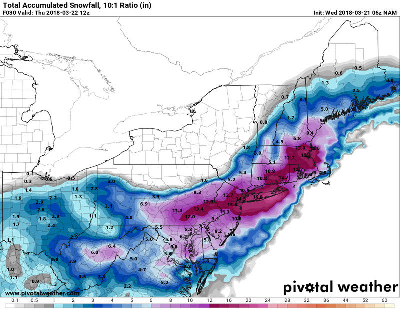
syosnow94 wrote:Upton just came out with their 4 am update and increased amounts for LI while decreasing elsewhere
They increased for Northeastern NJ, Westchester County, Fairfield County and Metro NYC too.
SoulSingMG- Senior Enthusiast
- Posts : 2853
Reputation : 74
Join date : 2013-12-11
Location : Long Island City, NY
Re: March Madness! Spring Snowstorm Observations
![]() by Guest Wed Mar 21, 2018 4:37 am
by Guest Wed Mar 21, 2018 4:37 am
Guest- Guest
Re: March Madness! Spring Snowstorm Observations
![]() by dkodgis Wed Mar 21, 2018 4:45 am
by dkodgis Wed Mar 21, 2018 4:45 am

dkodgis- Senior Enthusiast
- Posts : 2501
Reputation : 98
Join date : 2013-12-29
Re: March Madness! Spring Snowstorm Observations
![]() by jmanley32 Wed Mar 21, 2018 4:46 am
by jmanley32 Wed Mar 21, 2018 4:46 am

jmanley32- Senior Enthusiast
- Posts : 20516
Reputation : 108
Join date : 2013-12-12
Age : 42
Location : Yonkers, NY
Re: March Madness! Spring Snowstorm Observations
![]() by rb924119 Wed Mar 21, 2018 5:03 am
by rb924119 Wed Mar 21, 2018 5:03 am
Additionally, my analysis of WV imagery leads me to believe that our parent mid-level lows have gained a little more latitude than what guidance was suggesting which bodes well for us. Instead of exiting off of Virginia's latitude it would seem that the Delmarva would make more sense here, which is PERFECT FOR NEARLY ALL OF OUR FORUM. TRUST EYES NOT MODELS. MODELS HAVE BEEN USELESS SINCE LAST NIGHT. Back to bed now lol
rb924119- Meteorologist

- Posts : 6890
Reputation : 194
Join date : 2013-02-06
Age : 32
Location : Greentown, Pa
Re: March Madness! Spring Snowstorm Observations
![]() by jmanley32 Wed Mar 21, 2018 5:05 am
by jmanley32 Wed Mar 21, 2018 5:05 am
jmanley32- Senior Enthusiast
- Posts : 20516
Reputation : 108
Join date : 2013-12-12
Age : 42
Location : Yonkers, NY
Re: March Madness! Spring Snowstorm Observations
![]() by jmanley32 Wed Mar 21, 2018 5:09 am
by jmanley32 Wed Mar 21, 2018 5:09 am
they sure did dunno what syo talking bout. I saw a couple flakes but nothing of significance you have full on snow over there already,?SoulSingMG wrote:syosnow94 wrote:Upton just came out with their 4 am update and increased amounts for LI while decreasing elsewhere
They increased for Northeastern NJ, Westchester County, Fairfield County and Metro NYC too.
jmanley32- Senior Enthusiast
- Posts : 20516
Reputation : 108
Join date : 2013-12-12
Age : 42
Location : Yonkers, NY
Re: March Madness! Spring Snowstorm Observations
![]() by nutleyblizzard Wed Mar 21, 2018 5:11 am
by nutleyblizzard Wed Mar 21, 2018 5:11 am
They are probably looking at current observations and upper levels. Read RB's post.jmanley32 wrote:The models I no likey 10 inches on nam that's low for what's being forecasted , and heard euro was really bad? Where is nws get these high numbers from?

nutleyblizzard- Senior Enthusiast
- Posts : 1952
Reputation : 41
Join date : 2014-01-30
Age : 58
Location : Nutley, new jersey
Re: March Madness! Spring Snowstorm Observations
![]() by RJB8525 Wed Mar 21, 2018 5:20 am
by RJB8525 Wed Mar 21, 2018 5:20 am

RJB8525- Senior Enthusiast
- Posts : 1994
Reputation : 28
Join date : 2013-02-06
Age : 38
Location : Hackettstown, NJ
Page 25 of 40 • 1 ... 14 ... 24, 25, 26 ... 32 ... 40 ![]()
|
|
|