
 Search
March Madness! Spring Snowstorm Observations
Page 37 of 40 •  1 ... 20 ... 36, 37, 38, 39, 40
 ![]()
Re: March Madness! Spring Snowstorm Observations
![]() by docstox12 Wed Mar 21, 2018 12:11 pm
by docstox12 Wed Mar 21, 2018 12:11 pm
CPcantmeasuresnow wrote:jimv45 wrote:Dry air winning out up here! be lucky to get a dusting, but hey got the last 3 so good luck for our southern peeps enjoy.
20 miles south of you light to moderate snow now Jim but it took a long time to get to that yet it's still ahead of schedule of any model runs I saw yesterday.
Expect little give much will be our motto for the day. The further north you go the tougher it will be to get enough qpf. It's a shame to as I sit at 27.5 degrees. If we could squeeze out .5 I think we can get 6-8. Not sure if we will though, especially up as far as you.
CP, I think jimv and hyde are in trouble with the way this storm is developing.We are right at the very northern fringe of accumulating snow.Like you say, 6 to 8 will be great.Many of these models showed this.Maybe we will luck out with a nice band later.Was light to moderate snow, now nothing again.Ground got coated good though.
docstox12- Wx Statistician Guru

- Posts : 8530
Join date : 2013-01-07
Re: March Madness! Spring Snowstorm Observations
![]() by Sparky Sparticles Wed Mar 21, 2018 12:11 pm
by Sparky Sparticles Wed Mar 21, 2018 12:11 pm
BTW, what is "freezing fog"? That's part of the current weather conditions on the NWS page for our area: "31º Snow Freezing Fog"
Sparky Sparticles- Posts : 124
Join date : 2014-02-11
Re: March Madness! Spring Snowstorm Observations
![]() by SoulSingMG Wed Mar 21, 2018 12:13 pm
by SoulSingMG Wed Mar 21, 2018 12:13 pm
aiannone wrote:HRRR keeps getting worse.....

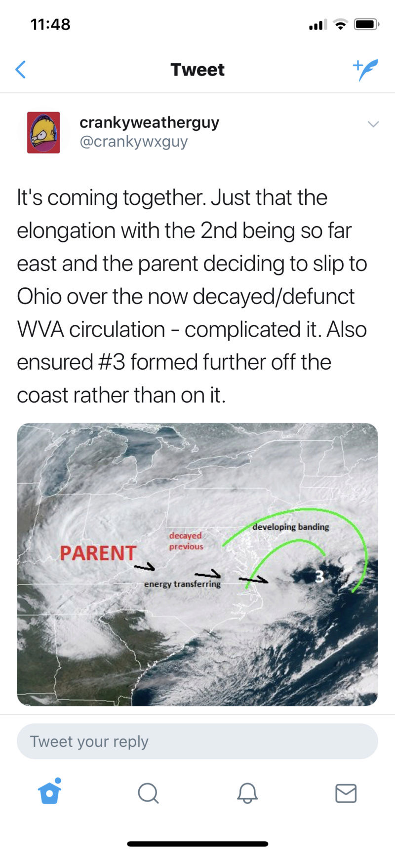
Lol. I am trying to communicate this. EAST NORTH EAST. Everything is progressive and the two pieces that were to make our storm a Godzilla slipped too far apart. It's elongated. Just look at obs.

SoulSingMG- Senior Enthusiast

- Posts : 2853
Reputation : 74
Join date : 2013-12-11
Location : Long Island City, NY
Re: March Madness! Spring Snowstorm Observations
![]() by docstox12 Wed Mar 21, 2018 12:14 pm
by docstox12 Wed Mar 21, 2018 12:14 pm
aiannone wrote:HRRR keeps getting worse.....
Wow, moving due East!

docstox12- Wx Statistician Guru
- Posts : 8530
Reputation : 222
Join date : 2013-01-07
Age : 73
Location : Monroe NY
Re: March Madness! Spring Snowstorm Observations
![]() by Guest Wed Mar 21, 2018 12:14 pm
by Guest Wed Mar 21, 2018 12:14 pm
dad4twoboys wrote:I found this ruler around Exit 44 Westbound L.I.E.
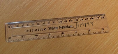
Great stuff
Guest- Guest


RJB8525- Senior Enthusiast
- Posts : 1994
Reputation : 28
Join date : 2013-02-06
Age : 38
Location : Hackettstown, NJ
Re: March Madness! Spring Snowstorm Observations
![]() by Sanchize06 Wed Mar 21, 2018 12:15 pm
by Sanchize06 Wed Mar 21, 2018 12:15 pm
SoulSingMG wrote:aiannone wrote:HRRR keeps getting worse.....
Lol. I am trying to communicate this. EAST NORTH EAST. Everything is progressive and the two pieces that were to make our storm a Godzilla slipped too far apart. It's elongated. Just look at obs.
Yep. You can't ignore real time observations like you can with models lol
Sanchize06- Senior Enthusiast
- Posts : 1041
Reputation : 21
Join date : 2013-02-05
Location : Union Beach, NJ
Re: March Madness! Spring Snowstorm Observations
![]() by Dtone Wed Mar 21, 2018 12:15 pm
by Dtone Wed Mar 21, 2018 12:15 pm
frank 638 wrote:Snow has stopped this sucks
Basically a light mist/flurries now.
Parts of Manhattan actually has an inch or so. Despite what radar shows seems like steady precip doesnt make it much north of 125 St. At least for now.
Dtone- Wx Statistician Guru
- Posts : 1738
Reputation : 9
Join date : 2013-08-26
Location : Bronx, NY
Re: March Madness! Spring Snowstorm Observations
![]() by weatherwatchermom Wed Mar 21, 2018 12:16 pm
by weatherwatchermom Wed Mar 21, 2018 12:16 pm

weatherwatchermom- Senior Enthusiast
- Posts : 3793
Reputation : 78
Join date : 2014-11-25
Location : Hazlet Township, NJ
Re: March Madness! Spring Snowstorm Observations
![]() by oldtimer Wed Mar 21, 2018 12:18 pm
by oldtimer Wed Mar 21, 2018 12:18 pm
oldtimer- Senior Enthusiast
- Posts : 1103
Reputation : 14
Join date : 2013-01-16
Age : 78
Location : Port Jefferson Station Suffolk County
Re: March Madness! Spring Snowstorm Observations
![]() by RJB8525 Wed Mar 21, 2018 12:18 pm
by RJB8525 Wed Mar 21, 2018 12:18 pm

RJB8525- Senior Enthusiast
- Posts : 1994
Reputation : 28
Join date : 2013-02-06
Age : 38
Location : Hackettstown, NJ
Re: March Madness! Spring Snowstorm Observations
![]() by rb924119 Wed Mar 21, 2018 12:18 pm
by rb924119 Wed Mar 21, 2018 12:18 pm
SoulSingMG wrote:rb924119 wrote:SoulSingMG wrote:Going back to bed :-(
He's just trying to verify his already busted forecast of 3-6" lol as WeatherBob et Al. have been saying, you have to watch the mid-levels, and they aren't here yet. considering the heaviest banding is already located OVER MARYLAND, DELAWARE, AND SE PA, I THINK HIS STATEMENT OF THE HEAVIEST BANDING OVER THE WATER IS DISPROVEN, just like Steve D lmao
So frustrating to wake up to a third potential bust in a month. This one hurts the most. You can see on the OBS everything sliding ENE. Quickly. Nothing in the Atlantic to stop it.
Dude, are you even looking at anything besides what that bumble is saying??? Mid-level lows are still over West Virginia, and are significantly further NORTHWEST of any modeling. Every single one of your models has the expanse of the precipitation shield undermodeled so far, aside from the HV. My dad in NEPA has three inches, which according to models shouldn't be, and yet he is now getting 1"+ per hour rates. Combine that with the further northwest placement of the mid-levels AT THE LATITUDE OF THE DELMARVA AND YOU HAVE A CLASSIC LOOK FOR A WIDESPREAD SNOWFALL SURROUNDING I-95. You just gotta be patient and let things happen. Good god. I have no dog in this fight and have no forecast to try to argue for; mine has already verified in that we have the storm to begin with, and I'm currently looking out my window at a veiled sun. But for God's sake trust the evolution and have some patience. As this system rotates through THIS EVENING you will get yours. It's not moving east to west, but the other way around. I gotta step away, as much as I love to see the obs, because all of the negative talk and blind panic all over the Weather community is ridiculous at this point. Enjoy the storm, folks!!! I'll check in a bit later!!!
rb924119- Meteorologist

- Posts : 6928
Reputation : 194
Join date : 2013-02-06
Age : 32
Location : Greentown, Pa
Re: March Madness! Spring Snowstorm Observations
![]() by oldtimer Wed Mar 21, 2018 12:22 pm
by oldtimer Wed Mar 21, 2018 12:22 pm
oldtimer- Senior Enthusiast
- Posts : 1103
Reputation : 14
Join date : 2013-01-16
Age : 78
Location : Port Jefferson Station Suffolk County
Re: March Madness! Spring Snowstorm Observations
![]() by SoulSingMG Wed Mar 21, 2018 12:22 pm
by SoulSingMG Wed Mar 21, 2018 12:22 pm
rb924119 wrote:SoulSingMG wrote:rb924119 wrote:SoulSingMG wrote:Going back to bed :-(
He's just trying to verify his already busted forecast of 3-6" lol as WeatherBob et Al. have been saying, you have to watch the mid-levels, and they aren't here yet. considering the heaviest banding is already located OVER MARYLAND, DELAWARE, AND SE PA, I THINK HIS STATEMENT OF THE HEAVIEST BANDING OVER THE WATER IS DISPROVEN, just like Steve D lmao
So frustrating to wake up to a third potential bust in a month. This one hurts the most. You can see on the OBS everything sliding ENE. Quickly. Nothing in the Atlantic to stop it.
Dude, are you even looking at anything besides what that bumble is saying??? Mid-level lows are still over West Virginia, and are significantly further NORTHWEST of any modeling. Every single one of your models has the expanse of the precipitation shield undermodeled so far, aside from the HV. My dad in NEPA has three inches, which according to models shouldn't be, and yet he is now getting 1"+ per hour rates. Combine that with the further northwest placement of the mid-levels AT THE LATITUDE OF THE DELMARVA AND YOU HAVE A CLASSIC LOOK FOR A WIDESPREAD SNOWFALL SURROUNDING I-95. You just gotta be patient and let things happen. Good god. I have no dog in this fight and have no forecast to try to argue for; mine has already verified in that we have the storm to begin with, and I'm currently looking out my window at a veiled sun. But for God's sake trust the evolution and have some patience. As this system rotates through THIS EVENING you will get yours. It's not moving east to west, but the other way around. I gotta step away, as much as I love to see the obs, because all of the negative talk and blind panic all over the Weather community is ridiculous at this point. Enjoy the storm, folks!!! I'll check in a bit later!!!
I think Rb just yelled at me. Kinda liked it. ;-)
We'll seeeeee, I suppose. But the concerns I am mentioning are not only "bumble's" — the HRRR for example, is deadly. I think that's why there's panic.
SoulSingMG- Senior Enthusiast
- Posts : 2853
Reputation : 74
Join date : 2013-12-11
Location : Long Island City, NY
Re: March Madness! Spring Snowstorm Observations
![]() by algae888 Wed Mar 21, 2018 12:25 pm
by algae888 Wed Mar 21, 2018 12:25 pm

algae888- Advanced Forecaster

- Posts : 5311
Reputation : 46
Join date : 2013-02-05
Age : 62
Location : mt. vernon, new york
Re: March Madness! Spring Snowstorm Observations
![]() by Grselig Wed Mar 21, 2018 12:25 pm
by Grselig Wed Mar 21, 2018 12:25 pm
rb924119 wrote:SoulSingMG wrote:rb924119 wrote:SoulSingMG wrote:Going back to bed :-(
He's just trying to verify his already busted forecast of 3-6" lol as WeatherBob et Al. have been saying, you have to watch the mid-levels, and they aren't here yet. considering the heaviest banding is already located OVER MARYLAND, DELAWARE, AND SE PA, I THINK HIS STATEMENT OF THE HEAVIEST BANDING OVER THE WATER IS DISPROVEN, just like Steve D lmao
So frustrating to wake up to a third potential bust in a month. This one hurts the most. You can see on the OBS everything sliding ENE. Quickly. Nothing in the Atlantic to stop it.
Dude, are you even looking at anything besides what that bumble is saying??? Mid-level lows are still over West Virginia, and are significantly further NORTHWEST of any modeling. Every single one of your models has the expanse of the precipitation shield undermodeled so far, aside from the HV. My dad in NEPA has three inches, which according to models shouldn't be, and yet he is now getting 1"+ per hour rates. Combine that with the further northwest placement of the mid-levels AT THE LATITUDE OF THE DELMARVA AND YOU HAVE A CLASSIC LOOK FOR A WIDESPREAD SNOWFALL SURROUNDING I-95. You just gotta be patient and let things happen. Good god. I have no dog in this fight and have no forecast to try to argue for; mine has already verified in that we have the storm to begin with, and I'm currently looking out my window at a veiled sun. But for God's sake trust the evolution and have some patience. As this system rotates through THIS EVENING you will get yours. It's not moving east to west, but the other way around. I gotta step away, as much as I love to see the obs, because all of the negative talk and blind panic all over the Weather community is ridiculous at this point. Enjoy the storm, folks!!! I'll check in a bit later!!!
You were forecasting this storm after last week's left noreaster. He was minimizing it. Nice going!!

Grselig- Senior Enthusiast
- Posts : 1408
Reputation : 140
Join date : 2013-03-04
Age : 54
Location : Wayne NJ
Re: March Madness! Spring Snowstorm Observations
![]() by Frank_Wx Wed Mar 21, 2018 12:26 pm
by Frank_Wx Wed Mar 21, 2018 12:26 pm
_________________
_______________________________________________________________________________________________________
CLICK HERE to view NJ Strong Snowstorm Classifications

Frank_Wx- Godzilla Seeker

- Posts : 21305
Reputation : 328
Join date : 2013-01-05
Age : 32
Location : Jersey City, NJ -

Re: March Madness! Spring Snowstorm Observations
![]() by Guest Wed Mar 21, 2018 12:26 pm
by Guest Wed Mar 21, 2018 12:26 pm
Guest- Guest
Re: March Madness! Spring Snowstorm Observations
![]() by CPcantmeasuresnow Wed Mar 21, 2018 12:27 pm
by CPcantmeasuresnow Wed Mar 21, 2018 12:27 pm
dad4twoboys wrote:I found this ruler around Exit 44 Westbound L.I.E.
Well whatever happens so far this is the post of the day.

CPcantmeasuresnow- Wx Statistician Guru
- Posts : 7274
Reputation : 230
Join date : 2013-01-07
Age : 103
Location : Eastern Orange County, NY
Re: March Madness! Spring Snowstorm Observations
![]() by sroc4 Wed Mar 21, 2018 12:27 pm
by sroc4 Wed Mar 21, 2018 12:27 pm
rb924119 wrote:SoulSingMG wrote:Going back to bed :-(
He's just trying to verify his already busted forecast of 3-6" lol as WeatherBob et Al. have been saying, you have to watch the mid-levels, and they aren't here yet. considering the heaviest banding is already located OVER MARYLAND, DELAWARE, AND SE PA, I THINK HIS STATEMENT OF THE HEAVIEST BANDING OVER THE WATER IS DISPROVEN, just like Steve D lmao
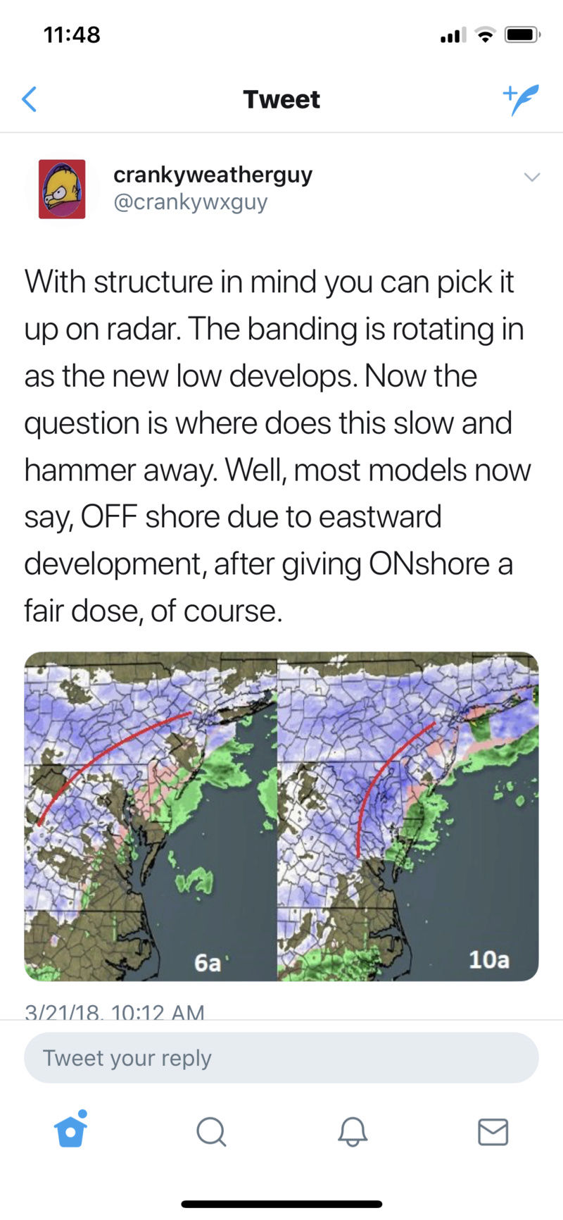
Thank you rb!!! Folks listen...maybe even screen shot this post and post it for them to see. Both of these guys are missing something here. The 500mb and 700mb lows are still well inland.
This was ALWAYS a two wave system the second of which was never going to get going until afternoon Wed. There are two surface low pressure centers as a result of this. With two centers you will have competition for where the surface winds want to go in between them. As a result yo get divergence in between these two centers rather than convergence and frontogenesis and you will not get consistent convection or banding..hence the fragmented bands. This is going to change as we go through the afternoon and evening hours.
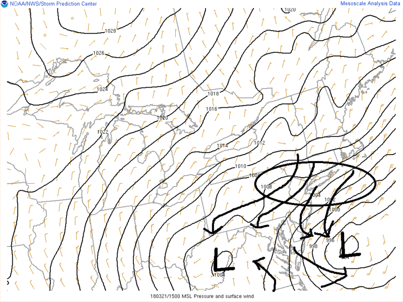
The h5 energy that wave one and generated the subsequent SLP, is being sheared by the confluence and the surface low conts to sit off the coast. However; it is going to cont to weaken throughout the day. Why??? Because.... The 500mb low is going to deepen as it slides off the coast...first E then head NE as it passes south of LI It is then and only then that we will see the new primary take over and be tugged back west some towards the strengthening ULL. Exactly how far south the H5 ULL passes willl determine if what they say is correct. So while they may be right in the end, they will be wrong in their reasoning. We have to wait and see A) what track does the H5 ULL take, and B) how strong does it get. These guys are Cranky and Stubborn the 8th and 9th dwarfs.
Last edited by sroc4 on Wed Mar 21, 2018 12:30 pm; edited 1 time in total
_________________
"In weather and in life, there's no winning and losing; there's only winning and learning."
WINTER 2012/2013 TOTALS 43.65"WINTER 2017/2018 TOTALS 62.85" WINTER 2022/2023 TOTALS 4.9"
WINTER 2013/2014 TOTALS 64.85"WINTER 2018/2019 TOTALS 14.25" WINTER 2023/2024 TOTALS 13.1"
WINTER 2014/2015 TOTALS 71.20"WINTER 2019/2020 TOTALS 6.35"
WINTER 2015/2016 TOTALS 35.00"WINTER 2020/2021 TOTALS 37.75"
WINTER 2016/2017 TOTALS 42.25"WINTER 2021/2022 TOTALS 31.65"

sroc4- Admin
- Posts : 8354
Reputation : 302
Join date : 2013-01-07
Location : Wading River, LI
Re: March Madness! Spring Snowstorm Observations
![]() by CPcantmeasuresnow Wed Mar 21, 2018 12:29 pm
by CPcantmeasuresnow Wed Mar 21, 2018 12:29 pm
syosnow94 wrote:I’m so confused right now. Are we busting potentially which would be a huuuuuuge coup for the EURO. Or are we still good?
How are the winds by you Syos?
CPcantmeasuresnow- Wx Statistician Guru
- Posts : 7274
Reputation : 230
Join date : 2013-01-07
Age : 103
Location : Eastern Orange County, NY
Re: March Madness! Spring Snowstorm Observations
![]() by sroc4 Wed Mar 21, 2018 12:30 pm
by sroc4 Wed Mar 21, 2018 12:30 pm
syosnow94 wrote:I’m so confused right now. Are we busting potentially which would be a huuuuuuge coup for the EURO. Or are we still good?
Read my latest post above....while we may bust, we are no where near busting yet
_________________
"In weather and in life, there's no winning and losing; there's only winning and learning."
WINTER 2012/2013 TOTALS 43.65"WINTER 2017/2018 TOTALS 62.85" WINTER 2022/2023 TOTALS 4.9"
WINTER 2013/2014 TOTALS 64.85"WINTER 2018/2019 TOTALS 14.25" WINTER 2023/2024 TOTALS 13.1"
WINTER 2014/2015 TOTALS 71.20"WINTER 2019/2020 TOTALS 6.35"
WINTER 2015/2016 TOTALS 35.00"WINTER 2020/2021 TOTALS 37.75"
WINTER 2016/2017 TOTALS 42.25"WINTER 2021/2022 TOTALS 31.65"
sroc4- Admin
- Posts : 8354
Reputation : 302
Join date : 2013-01-07
Location : Wading River, LI
Re: March Madness! Spring Snowstorm Observations
![]() by aiannone Wed Mar 21, 2018 12:31 pm
by aiannone Wed Mar 21, 2018 12:31 pm
sroc4 wrote:rb924119 wrote:SoulSingMG wrote:Going back to bed :-(
He's just trying to verify his already busted forecast of 3-6" lol as WeatherBob et Al. have been saying, you have to watch the mid-levels, and they aren't here yet. considering the heaviest banding is already located OVER MARYLAND, DELAWARE, AND SE PA, I THINK HIS STATEMENT OF THE HEAVIEST BANDING OVER THE WATER IS DISPROVEN, just like Steve D lmao
Thank you rb!!! Folks listen...maybe even screen shot this post and post it for them to see. Both of these guys are missing something here. The 500mb and 700mb lows are still well inland.
This was ALWAYS a two wave system the second of which was never going to get going until afternoon Wed. There are two surface low pressure centers as a result of this. With two centers you will have competition for where the surface winds want to go in between them. As a result of divergence in between these two centers you will not get consistent convection. This is going to change as we go through the afternoon and evening hours.
The h5 energy that wave one and generated the subsequent SLP, is being sheared by the confluence and the surface low conts to sit off the coast. However; it is going to cont to weaken throughout the day. Why??? Because.... The 500mb low is going to deepen as it slides off the coast...first E then head NE as it passes south of LI It is then and only then that we will see the new primary take over and be tugged back west some towards the strengthening ULL. Exactly how far south the H5 ULL passes willl determine if what they say is correct. So while they may be right in the end, they will be wrong in their reasoning. We have to wait and see A) what track does the H5 ULL take, and B) how strong does it get. These guys are Cranky and Stubborn the 8th and 9th dwarfs.
I agree with your anaylsis, but can you guys comment on this part of their theory. They mentioned the initial low that is inland is stronger than modeled, which in combination with an elongated low off the coast, it's causing that elongated low to be shoved further east, and therefore their phase to occur further off the coast.
_________________
-Alex Iannone-

aiannone- Senior Enthusiast - Mod

- Posts : 4815
Reputation : 92
Join date : 2013-01-07
Location : Saint James, LI (Northwest Suffolk Co.)
Re: March Madness! Spring Snowstorm Observations
![]() by SoulSingMG Wed Mar 21, 2018 12:32 pm
by SoulSingMG Wed Mar 21, 2018 12:32 pm
sroc4 wrote:rb924119 wrote:SoulSingMG wrote:Going back to bed :-(
He's just trying to verify his already busted forecast of 3-6" lol as WeatherBob et Al. have been saying, you have to watch the mid-levels, and they aren't here yet. considering the heaviest banding is already located OVER MARYLAND, DELAWARE, AND SE PA, I THINK HIS STATEMENT OF THE HEAVIEST BANDING OVER THE WATER IS DISPROVEN, just like Steve D lmao
Thank you rb!!! Folks listen...maybe even screen shot this post and post it for them to see. Both of these guys are missing something here. The 500mb and 700mb lows are still well inland.
This was ALWAYS a two wave system the second of which was never going to get going until afternoon Wed. There are two surface low pressure centers as a result of this. With two centers you will have competition for where the surface winds want to go in between them. As a result of divergence in between these two centers you will not get consistent convection. This is going to change as we go through the afternoon and evening hours.
The h5 energy that wave one and generated the subsequent SLP, is being sheared by the confluence and the surface low conts to sit off the coast. However; it is going to cont to weaken throughout the day. Why??? Because.... The 500mb low is going to deepen as it slides off the coast...first E then head NE as it passes south of LI It is then and only then that we will see the new primary take over and be tugged back west some towards the strengthening ULL. Exactly how far south the H5 ULL passes willl determine if what they say is correct. So while they may be right in the end, they will be wrong in their reasoning. We have to wait and see A) what track does the H5 ULL take, and B) how strong does it get. These guys are Cranky and Stubborn the 8th and 9th dwarfs.
Lol! I am laughing out loud. Thanks tho—this actually makes more sense to me. Could this mean the HRRR for example is "chasing" the wrong (1st) wave energy hence the eastern runs of late?
SoulSingMG- Senior Enthusiast
- Posts : 2853
Reputation : 74
Join date : 2013-12-11
Location : Long Island City, NY
Re: March Madness! Spring Snowstorm Observations
![]() by Joe Snow Wed Mar 21, 2018 12:33 pm
by Joe Snow Wed Mar 21, 2018 12:33 pm
RE -POSTING WHEN THIS GETS GOING WE WILL BE GOOD

Joe Snow- Pro Enthusiast

- Posts : 924
Reputation : 7
Join date : 2014-02-12
Age : 62
Location : Sanford Florida, Fmrly Kings Park, NY
Re: March Madness! Spring Snowstorm Observations
![]() by frank 638 Wed Mar 21, 2018 12:33 pm
by frank 638 Wed Mar 21, 2018 12:33 pm
frank 638- Senior Enthusiast
- Posts : 2843
Reputation : 37
Join date : 2016-01-01
Age : 40
Location : bronx ny
Re: March Madness! Spring Snowstorm Observations
![]() by Frank_Wx Wed Mar 21, 2018 12:33 pm
by Frank_Wx Wed Mar 21, 2018 12:33 pm

_________________
_______________________________________________________________________________________________________
CLICK HERE to view NJ Strong Snowstorm Classifications
Frank_Wx- Godzilla Seeker
- Posts : 21305
Reputation : 328
Join date : 2013-01-05
Age : 32
Location : Jersey City, NJ -
Page 37 of 40 • 1 ... 20 ... 36, 37, 38, 39, 40 ![]()
|
|
|