
 Search
May 2018 Observations & Discussions
Page 3 of 7 •  1, 2, 3, 4, 5, 6, 7
 ![]()
Re: May 2018 Observations & Discussions
![]() by bluebythec Sat May 12, 2018 6:55 pm
by bluebythec Sat May 12, 2018 6:55 pm
THE NATIONAL WEATHER SERVICE HAS ISSUED TORNADO WATCH 85 IN
EFFECT UNTIL 1 AM EDT SUNDAY FOR THE FOLLOWING AREAS
IN DELAWARE THIS WATCH INCLUDES 3 COUNTIES
IN CENTRAL DELAWARE
KENT
IN NORTHERN DELAWARE
NEW CASTLE
IN SOUTHERN DELAWARE
SUSSEX
IN MARYLAND THIS WATCH INCLUDES 5 COUNTIES
IN NORTHEAST MARYLAND
CAROLINE CECIL KENT
QUEEN ANNE'S TALBOT
IN NEW JERSEY THIS WATCH INCLUDES 8 COUNTIES
IN SOUTHERN NEW JERSEY
ATLANTIC BURLINGTON CAMDEN
CAPE MAY CUMBERLAND GLOUCESTER
OCEAN SALEM
bluebythec- Posts : 7
Join date : 2015-02-15
Re: May 2018 Observations & Discussions
![]() by amugs Sun May 13, 2018 9:46 am
by amugs Sun May 13, 2018 9:46 am
amugs- Advanced Forecaster - Mod

- Posts : 15095
Join date : 2013-01-07
Re: May 2018 Observations & Discussions
![]() by frank 638 Sun May 13, 2018 11:32 am
by frank 638 Sun May 13, 2018 11:32 am
frank 638- Senior Enthusiast

- Posts : 2843
Reputation : 37
Join date : 2016-01-01
Age : 40
Location : bronx ny
Re: May 2018 Observations & Discussions
![]() by amugs Sun May 13, 2018 12:17 pm
by amugs Sun May 13, 2018 12:17 pm
_________________
Mugs
AKA:King: Snow Weenie
Self Proclaimed
WINTER 2014-15 : 55.12" +.02 for 6 coatings (avg. 35")
WINTER 2015-16 Total - 29.8" (Avg 35")
WINTER 2016-17 : 39.5" so far

amugs- Advanced Forecaster - Mod
- Posts : 15095
Reputation : 213
Join date : 2013-01-07
Age : 54
Location : Hillsdale,NJ
Re: May 2018 Observations & Discussions
![]() by Radz Sun May 13, 2018 6:24 pm
by Radz Sun May 13, 2018 6:24 pm
I think quite a few will start peering in as the threat gets closer, and agree tropics may get an early start...rb924119 wrote:Scott!!! Well now it's officially a tracking party! Haha

Radz- Pro Enthusiast

- Posts : 1028
Reputation : 17
Join date : 2013-01-12
Location : Cortlandt Manor NY
Re: May 2018 Observations & Discussions
![]() by Quietace Sun May 13, 2018 6:37 pm
by Quietace Sun May 13, 2018 6:37 pm
The GFS schemes are grossly inadequate for forecasting TC's. The FV3 is running more time steps, with the same resolution and physics as the OP GFS currently. This leads to the same errors, which can be exasperated. The GFS will show a TC past day 10 for the rest of the season with little temporal movement towards the near term. This is because it is a systematic error within itself. Thus, do not get worked up over it, and secondly, do not believe it.
The Caribbean is leaning more favorable in the 10-15 day period for some sort of cyclogeneis. However, there is little certainty if it will occur, and if it does, what will come of it. Once thing is for certain, the GFS is not forming that TC because of pattern progression.

Quietace- Meteorologist - Mod

- Posts : 3689
Reputation : 33
Join date : 2013-01-07
Age : 27
Location : Point Pleasant, NJ
Re: May 2018 Observations & Discussions
![]() by rb924119 Sun May 13, 2018 6:38 pm
by rb924119 Sun May 13, 2018 6:38 pm
Also, and admittedly this is banter, but is related to the topic at hand; I just invested in a second 27" 5k monitor to use with my 27" desktop. Reason? ALL THE BETTER TO FORECAST WITH!!!!!! Can't wait to get it and set it up next week!!!!!!!
rb924119- Meteorologist

- Posts : 6928
Reputation : 194
Join date : 2013-02-06
Age : 32
Location : Greentown, Pa
Re: May 2018 Observations & Discussions
![]() by rb924119 Sun May 13, 2018 6:43 pm
by rb924119 Sun May 13, 2018 6:43 pm
Quietace wrote:This is a public service announcement.
The GFS schemes are grossly inadequate for forecasting TC's. The FV3 is running more time steps, with the same resolution and physics as the OP GFS currently. This leads to the same errors, which can be exasperated. The GFS will show a TC past day 10 for the rest of the season with little temporal movement towards the near term. This is because it is a systematic error within itself. Thus, do not get worked up over it, and secondly, do not believe it.
The Caribbean is leaning more favorable in the 10-15 day period for some sort of cyclogeneis. However, there is little certainty if it will occur, and if it does, what will come of it. Once thing is for certain, the GFS is not forming that TC because of pattern progression.
Thanks for the Intel, Ryan!!! I haven't had a chance to delve into the differences, so your information is much appreciated. However, I must respectfully disagree, but only in this certain case, as the solutions those two models, and now the ICON, CMC to a degree, and the CFSV2 are all showing DO fit the pattern profession; and they fit it quite well in my humble opinion. Obviously, as you stated, it's far from certain, but I'm certainly expecting it to play out, and have for some time given the factors in play. In a vast majority of other instances, you are most certainly correct in stating that the GFS is horrible with tropics, as well as pretty much most everything else aha
rb924119- Meteorologist
- Posts : 6928
Reputation : 194
Join date : 2013-02-06
Age : 32
Location : Greentown, Pa
Re: May 2018 Observations & Discussions
![]() by rb924119 Sun May 13, 2018 6:45 pm
by rb924119 Sun May 13, 2018 6:45 pm
rb924119- Meteorologist
- Posts : 6928
Reputation : 194
Join date : 2013-02-06
Age : 32
Location : Greentown, Pa
Re: May 2018 Observations & Discussions
![]() by Quietace Sun May 13, 2018 6:51 pm
by Quietace Sun May 13, 2018 6:51 pm
No model is remotely close to the GFS's solution as a result of its poor TC handling. I am not stating that a low will not form, or that it is not favorable. I previously stated the region was favorable for cyclogenesis. I am simply stating that the GFS is forming the low, and then intensifying it, as a result of that poor TC handling. If it was pattern driven (In the model itself), it would not still be at 384 hours. It is no consolation that the EC and its ensembles also are rather weak with it, as is the rest of guidance. I do not have time to go back and forth, but we will see how this pans out over the next few days. All the best RB!rb924119 wrote:Quietace wrote:This is a public service announcement.
The GFS schemes are grossly inadequate for forecasting TC's. The FV3 is running more time steps, with the same resolution and physics as the OP GFS currently. This leads to the same errors, which can be exasperated. The GFS will show a TC past day 10 for the rest of the season with little temporal movement towards the near term. This is because it is a systematic error within itself. Thus, do not get worked up over it, and secondly, do not believe it.
The Caribbean is leaning more favorable in the 10-15 day period for some sort of cyclogeneis. However, there is little certainty if it will occur, and if it does, what will come of it. Once thing is for certain, the GFS is not forming that TC because of pattern progression.
Thanks for the Intel, Ryan!!! I haven't had a chance to delve into the differences, so your information is much appreciated. However, I must respectfully disagree, but only in this certain case, as the solutions those two models, and now the ICON, CMC to a degree, and the CFSV2 are all showing DO fit the pattern profession; and they fit it quite well in my humble opinion. Obviously, as you stated, it's far from certain, but I'm certainly expecting it to play out, and have for some time given the factors in play. In a vast majority of other instances, you are most certainly correct in stating that the GFS is horrible with tropics, as well as pretty much most everything else aha
Quietace- Meteorologist - Mod
- Posts : 3689
Reputation : 33
Join date : 2013-01-07
Age : 27
Location : Point Pleasant, NJ
Re: May 2018 Observations & Discussions
![]() by rb924119 Sun May 13, 2018 8:36 pm
by rb924119 Sun May 13, 2018 8:36 pm
Quietace wrote:No model is remotely close to the GFS's solution as a result of its poor TC handling. I am not stating that a low will not form, or that it is not favorable. I previously stated the region was favorable for cyclogenesis. I am simply stating that the GFS is forming the low, and then intensifying it, as a result of that poor TC handling. If it was pattern driven (In the model itself), it would not still be at 384 hours. It is no consolation that the EC and its ensembles also are rather weak with it, as is the rest of guidance. I do not have time to go back and forth, but we will see how this pans out over the next few days. All the best RB!rb924119 wrote:Quietace wrote:This is a public service announcement.
The GFS schemes are grossly inadequate for forecasting TC's. The FV3 is running more time steps, with the same resolution and physics as the OP GFS currently. This leads to the same errors, which can be exasperated. The GFS will show a TC past day 10 for the rest of the season with little temporal movement towards the near term. This is because it is a systematic error within itself. Thus, do not get worked up over it, and secondly, do not believe it.
The Caribbean is leaning more favorable in the 10-15 day period for some sort of cyclogeneis. However, there is little certainty if it will occur, and if it does, what will come of it. Once thing is for certain, the GFS is not forming that TC because of pattern progression.
Thanks for the Intel, Ryan!!! I haven't had a chance to delve into the differences, so your information is much appreciated. However, I must respectfully disagree, but only in this certain case, as the solutions those two models, and now the ICON, CMC to a degree, and the CFSV2 are all showing DO fit the pattern profession; and they fit it quite well in my humble opinion. Obviously, as you stated, it's far from certain, but I'm certainly expecting it to play out, and have for some time given the factors in play. In a vast majority of other instances, you are most certainly correct in stating that the GFS is horrible with tropics, as well as pretty much most everything else aha
I understand your issue with time constraints, but as a quick counter (again, respectfully), all sources of guidance I mentioned have the "system of interest" now within the 7-10 day period, though as you stated, to varying degrees of intensity. However, the development has consistently remained within the same approximate development period through several days of cycles. I think what you're referencing is more or less the speed of northward/eastward progression, and not necessarily the development. As for the intensification and forecast strength of this system, what PHYSICAL reason(s) do you see to be of the opinion that intensification on the order of what the average of the GFS runs has been is unreasonable, and the other guidance is to be trusted (ignoring model algorithms, etc.)? Personally, I think the GFS/FV3-GFS solutions for the physical forcing mechanisms fit much better than the other guidance, and expect it to begin showing up with more consistency in due time. This is a prime example of pattern recognition versus taking modeling "at face value". Now, I full well know you're a bright meteorologist and you have your reasons, and these questions are not only directed at you, as again, I understand your time constraints - I am merely providing talking points to further this discussion for ANYBODY who wishes to chime in. If you have the time, I'd absolutely love to see your response, though, buddy!!! I hope you're enjoying your official title, my friend!!! Haha
rb924119- Meteorologist
- Posts : 6928
Reputation : 194
Join date : 2013-02-06
Age : 32
Location : Greentown, Pa
Re: May 2018 Observations & Discussions
![]() by sroc4 Mon May 14, 2018 12:15 pm
by sroc4 Mon May 14, 2018 12:15 pm


_________________
"In weather and in life, there's no winning and losing; there's only winning and learning."
WINTER 2012/2013 TOTALS 43.65"WINTER 2017/2018 TOTALS 62.85" WINTER 2022/2023 TOTALS 4.9"
WINTER 2013/2014 TOTALS 64.85"WINTER 2018/2019 TOTALS 14.25" WINTER 2023/2024 TOTALS 13.1"
WINTER 2014/2015 TOTALS 71.20"WINTER 2019/2020 TOTALS 6.35"
WINTER 2015/2016 TOTALS 35.00"WINTER 2020/2021 TOTALS 37.75"
WINTER 2016/2017 TOTALS 42.25"WINTER 2021/2022 TOTALS 31.65"

sroc4- Admin

- Posts : 8354
Reputation : 302
Join date : 2013-01-07
Location : Wading River, LI
Re: May 2018 Observations & Discussions
![]() by sroc4 Mon May 14, 2018 12:19 pm
by sroc4 Mon May 14, 2018 12:19 pm
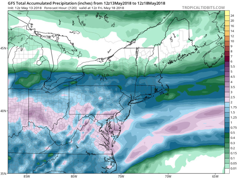
rb924119 wrote:I honestly haven't been paying too much attention these last couple weeks. I've been so busy doing firewood on my weekends and then working I haven't much time to actually sit down and look. That said, I DO think the MJO is making itself known as the 6-10 day forecasts appear to be backing down from their corresponding temperature forecasts in the 10-15 over the last several days of cycles. Again, I cannot concretely confirm or deny that, though, as I haven't actually sat down and done "one-to-one" comparisons. I WILL say I'm still very anxious to see if something tropical (or sub-tropical) tries popping once the MJO rolls into Phase 2, as I believe that phase corresponds very well to development in the Gulf and along and/or just offshore of the Southeast coast, as well as the time-mean surface pressures remaining higher than normal across the east-central U.S. thanks to anomalous soil moisture content leading to cooler than average surface temperatures and resultant higher pressure then aided by the MJO Phase 2 (probably should confirm that, but I'm pretty sure I remember reading a paper or two on the MJO a while back......my memory is shotty AT BEST, though so take that with extreme caution hahahaha)
As a follow-up, I like the period from ~May 15th through ~May 25th for our first true tropical/sub-tropical system to develop either in the western/northwestern Caribbean, Gulf, and or extreme western Atlantic. The reasons were generally discussed above, but I also like the look of -AO and negative SOI to assist penetrating, albeit transient troughs cutting through the eastern CONUS. This will help supply the surface ridging and aid in enhanced lower-level convergence along and near the coasts. I'm officially on the board with a forecast, so let's see how this pans out!!! Haha any thoughts?
A trough split will be the most likely culprit that then feeds back close to land rather than a classic tropical system that develops from scratch.
From May 7th:
Love it!
_________________
"In weather and in life, there's no winning and losing; there's only winning and learning."
WINTER 2012/2013 TOTALS 43.65"WINTER 2017/2018 TOTALS 62.85" WINTER 2022/2023 TOTALS 4.9"
WINTER 2013/2014 TOTALS 64.85"WINTER 2018/2019 TOTALS 14.25" WINTER 2023/2024 TOTALS 13.1"
WINTER 2014/2015 TOTALS 71.20"WINTER 2019/2020 TOTALS 6.35"
WINTER 2015/2016 TOTALS 35.00"WINTER 2020/2021 TOTALS 37.75"
WINTER 2016/2017 TOTALS 42.25"WINTER 2021/2022 TOTALS 31.65"
sroc4- Admin
- Posts : 8354
Reputation : 302
Join date : 2013-01-07
Location : Wading River, LI
Re: May 2018 Observations & Discussions
![]() by SoulSingMG Mon May 14, 2018 12:49 pm
by SoulSingMG Mon May 14, 2018 12:49 pm
sroc4 wrote:rb924119 wrote:I honestly haven't been paying too much attention these last couple weeks. I've been so busy doing firewood on my weekends and then working I haven't much time to actually sit down and look. That said, I DO think the MJO is making itself known as the 6-10 day forecasts appear to be backing down from their corresponding temperature forecasts in the 10-15 over the last several days of cycles. Again, I cannot concretely confirm or deny that, though, as I haven't actually sat down and done "one-to-one" comparisons. I WILL say I'm still very anxious to see if something tropical (or sub-tropical) tries popping once the MJO rolls into Phase 2, as I believe that phase corresponds very well to development in the Gulf and along and/or just offshore of the Southeast coast, as well as the time-mean surface pressures remaining higher than normal across the east-central U.S. thanks to anomalous soil moisture content leading to cooler than average surface temperatures and resultant higher pressure then aided by the MJO Phase 2 (probably should confirm that, but I'm pretty sure I remember reading a paper or two on the MJO a while back......my memory is shotty AT BEST, though so take that with extreme caution hahahaha)
As a follow-up, I like the period from ~May 15th through ~May 25th for our first true tropical/sub-tropical system to develop either in the western/northwestern Caribbean, Gulf, and or extreme western Atlantic. The reasons were generally discussed above, but I also like the look of -AO and negative SOI to assist penetrating, albeit transient troughs cutting through the eastern CONUS. This will help supply the surface ridging and aid in enhanced lower-level convergence along and near the coasts. I'm officially on the board with a forecast, so let's see how this pans out!!! Haha any thoughts?
A trough split will be the most likely culprit that then feeds back close to land rather than a classic tropical system that develops from scratch.
From May 7th:
Love it!
Wow. That's some good sh*t right there. Nice work, Rb. Hello everyone else! Severe weather threat looks ripe for mañana!

SoulSingMG- Senior Enthusiast
- Posts : 2853
Reputation : 74
Join date : 2013-12-11
Location : Long Island City, NY
Re: May 2018 Observations & Discussions
![]() by amugs Mon May 14, 2018 9:37 pm
by amugs Mon May 14, 2018 9:37 pm

_________________
Mugs
AKA:King: Snow Weenie
Self Proclaimed
WINTER 2014-15 : 55.12" +.02 for 6 coatings (avg. 35")
WINTER 2015-16 Total - 29.8" (Avg 35")
WINTER 2016-17 : 39.5" so far
amugs- Advanced Forecaster - Mod
- Posts : 15095
Reputation : 213
Join date : 2013-01-07
Age : 54
Location : Hillsdale,NJ
Re: May 2018 Observations & Discussions
![]() by billg315 Mon May 14, 2018 10:28 pm
by billg315 Mon May 14, 2018 10:28 pm

billg315- Advanced Forecaster - Mod
- Posts : 4483
Reputation : 185
Join date : 2015-01-24
Age : 50
Location : Flemington, NJ
Re: May 2018 Observations & Discussions
![]() by SoulSingMG Tue May 15, 2018 2:14 am
by SoulSingMG Tue May 15, 2018 2:14 am
SoulSingMG- Senior Enthusiast
- Posts : 2853
Reputation : 74
Join date : 2013-12-11
Location : Long Island City, NY
Re: May 2018 Observations & Discussions
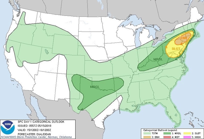
![]() by Snow88 Tue May 15, 2018 10:08 am
by Snow88 Tue May 15, 2018 10:08 am
64 degrees
Looking forward to the severe threat later on unless it falls apart before reaching the coast .
ABC 7


Snow88- Senior Enthusiast
- Posts : 2193
Reputation : 4
Join date : 2013-01-09
Age : 35
Location : Brooklyn, NY
Re: May 2018 Observations & Discussions
![]() by dkodgis Tue May 15, 2018 11:49 am
by dkodgis Tue May 15, 2018 11:49 am

dkodgis- Senior Enthusiast
- Posts : 2560
Reputation : 98
Join date : 2013-12-29
Re: May 2018 Observations & Discussions
![]() by jmanley32 Tue May 15, 2018 12:14 pm
by jmanley32 Tue May 15, 2018 12:14 pm

jmanley32- Senior Enthusiast
- Posts : 20535
Reputation : 108
Join date : 2013-12-12
Age : 43
Location : Yonkers, NY
Re: May 2018 Observations & Discussions
![]() by SoulSingMG Tue May 15, 2018 12:30 pm
by SoulSingMG Tue May 15, 2018 12:30 pm
SoulSingMG- Senior Enthusiast
- Posts : 2853
Reputation : 74
Join date : 2013-12-11
Location : Long Island City, NY
Re: May 2018 Observations & Discussions
![]() by SoulSingMG Tue May 15, 2018 12:48 pm
by SoulSingMG Tue May 15, 2018 12:48 pm
SoulSingMG- Senior Enthusiast
- Posts : 2853
Reputation : 74
Join date : 2013-12-11
Location : Long Island City, NY
Re: May 2018 Observations & Discussions
![]() by jimv45 Tue May 15, 2018 1:23 pm
by jimv45 Tue May 15, 2018 1:23 pm
jimv45- Senior Enthusiast
- Posts : 1168
Reputation : 36
Join date : 2013-09-20
Location : Hopewell jct.
Re: May 2018 Observations & Discussions
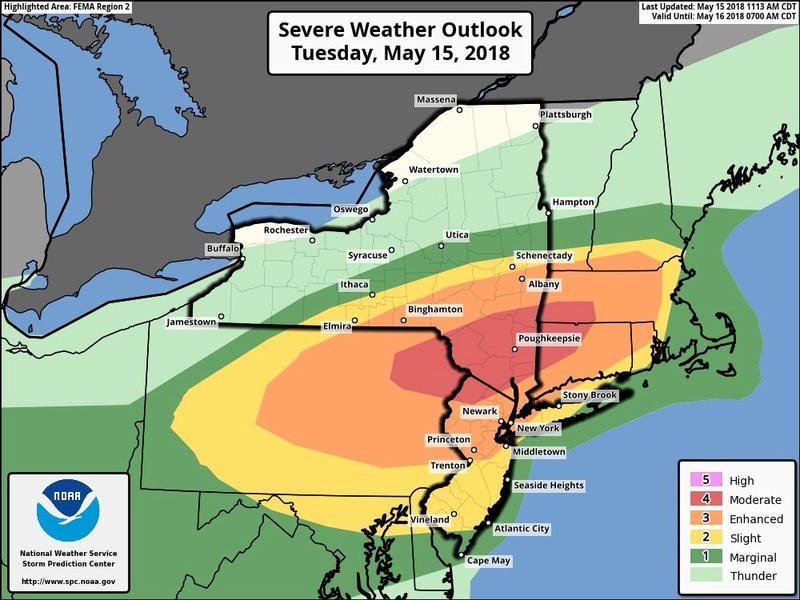
![]() by jmanley32 Tue May 15, 2018 2:24 pm
by jmanley32 Tue May 15, 2018 2:24 pm
shoot wow for real?! Oh not down here. Still could b pretty bad all way to coast.SoulSingMG wrote:JUST IN. Holy crap. It is not often you see "moderate" around here.
jmanley32- Senior Enthusiast
- Posts : 20535
Reputation : 108
Join date : 2013-12-12
Age : 43
Location : Yonkers, NY
Re: May 2018 Observations & Discussions
![]() by amugs Tue May 15, 2018 2:47 pm
by amugs Tue May 15, 2018 2:47 pm
_________________
Mugs
AKA:King: Snow Weenie
Self Proclaimed
WINTER 2014-15 : 55.12" +.02 for 6 coatings (avg. 35")
WINTER 2015-16 Total - 29.8" (Avg 35")
WINTER 2016-17 : 39.5" so far
amugs- Advanced Forecaster - Mod
- Posts : 15095
Reputation : 213
Join date : 2013-01-07
Age : 54
Location : Hillsdale,NJ
Re: May 2018 Observations & Discussions
![]() by amugs Tue May 15, 2018 3:09 pm
by amugs Tue May 15, 2018 3:09 pm
https://radar.weather.gov/Legend/NCR/BGM_NCR_Legend_0.gif

_________________
Mugs
AKA:King: Snow Weenie
Self Proclaimed
WINTER 2014-15 : 55.12" +.02 for 6 coatings (avg. 35")
WINTER 2015-16 Total - 29.8" (Avg 35")
WINTER 2016-17 : 39.5" so far
amugs- Advanced Forecaster - Mod
- Posts : 15095
Reputation : 213
Join date : 2013-01-07
Age : 54
Location : Hillsdale,NJ
Re: May 2018 Observations & Discussions
![]() by Dtone Tue May 15, 2018 4:26 pm
by Dtone Tue May 15, 2018 4:26 pm
89 here dew 66. winds picking up and increasing clouds to the NW.
Dtone- Wx Statistician Guru

- Posts : 1738
Reputation : 9
Join date : 2013-08-26
Location : Bronx, NY
Page 3 of 7 • 1, 2, 3, 4, 5, 6, 7 ![]()
|
|
|