
 Search
July 2018 Obs and Discussion
Page 3 of 7 •  1, 2, 3, 4, 5, 6, 7
 ![]()
skinsfan1177- Senior Enthusiast

- Posts : 4485
Join date : 2013-01-07
Re: July 2018 Obs and Discussion
![]() by GreyBeard Fri Jul 13, 2018 3:30 pm
by GreyBeard Fri Jul 13, 2018 3:30 pm
GreyBeard- Senior Enthusiast
- Posts : 731
Join date : 2014-02-12
Re: July 2018 Obs and Discussion
![]() by 1190ftalt Sat Jul 14, 2018 11:09 pm
by 1190ftalt Sat Jul 14, 2018 11:09 pm

1190ftalt- Pro Enthusiast

- Posts : 404
Reputation : 10
Join date : 2013-12-13
Location : Stillwater, NJ
Re: July 2018 Obs and Discussion
![]() by Dunnzoo Sun Jul 15, 2018 8:10 am
by Dunnzoo Sun Jul 15, 2018 8:10 am
_________________
Janet
Snowfall winter of 2023-2024 17.5"
Snowfall winter of 2022-2023 6.0"
Snowfall winter of 2021-2022 17.6" 1" sleet 2/25/22
Snowfall winter of 2020-2021 51.1"
Snowfall winter of 2019-2020 8.5"
Snowfall winter of 2018-2019 25.1"
Snowfall winter of 2017-2018 51.9"
Snowfall winter of 2016-2017 45.6"
Snowfall winter of 2015-2016 29.5"
Snowfall winter of 2014-2015 50.55"
Snowfall winter of 2013-2014 66.5"

Dunnzoo- Senior Enthusiast - Mod

- Posts : 4920
Reputation : 68
Join date : 2013-01-11
Age : 62
Location : Westwood, NJ
Re: July 2018 Obs and Discussion
![]() by Quietace Mon Jul 16, 2018 6:23 am
by Quietace Mon Jul 16, 2018 6:23 am

Quietace- Meteorologist - Mod

- Posts : 3689
Reputation : 33
Join date : 2013-01-07
Age : 27
Location : Point Pleasant, NJ
Re: July 2018 Obs and Discussion
![]() by sroc4 Mon Jul 16, 2018 7:14 am
by sroc4 Mon Jul 16, 2018 7:14 am
Quietace wrote:This upcoming weekend may be interesting.
It certainly does. Looks like there will be some left over energy sitting off the SE coast following the passing of the front Tuesday that possibly spins up as a subtrop or trop system as we head into the weekend. An approaching long wave trough, neg tilted if your the euro, draws it in. The approaching trough and building W Atl ridge has the EC sandwiched in the middle tapping into a deep trop/sub trop moisture fetch regardless for the weekend into next week. Parts of the area could get quite a bit of rain.
_________________
"In weather and in life, there's no winning and losing; there's only winning and learning."
WINTER 2012/2013 TOTALS 43.65"WINTER 2017/2018 TOTALS 62.85" WINTER 2022/2023 TOTALS 4.9"
WINTER 2013/2014 TOTALS 64.85"WINTER 2018/2019 TOTALS 14.25" WINTER 2023/2024 TOTALS 13.1"
WINTER 2014/2015 TOTALS 71.20"WINTER 2019/2020 TOTALS 6.35"
WINTER 2015/2016 TOTALS 35.00"WINTER 2020/2021 TOTALS 37.75"
WINTER 2016/2017 TOTALS 42.25"WINTER 2021/2022 TOTALS 31.65"

sroc4- Admin

- Posts : 8441
Reputation : 302
Join date : 2013-01-07
Location : Wading River, LI
Re: July 2018 Obs and Discussion
![]() by Quietace Mon Jul 16, 2018 1:48 pm
by Quietace Mon Jul 16, 2018 1:48 pm
I am not sure about formation potential, however, I would agree with you that the area will feature more of an enhanced moisture feed scenario with heavy downpours and widespread significant rains. I think you may have to watch surface winds as well (nothing damaging, but gusty onshore flow). Also, guidance is leaning towards an almost stationary pattern of some sort during days 6-10, which would also feature more precip for the area. I will have to take a closer look at this in the AM.sroc4 wrote:Quietace wrote:This upcoming weekend may be interesting.
It certainly does. Looks like there will be some left over energy sitting off the SE coast following the passing of the front Tuesday that possibly spins up as a subtrop or trop system as we head into the weekend. An approaching long wave trough, neg tilted if your the euro, draws it in. The approaching trough and building W Atl ridge has the EC sandwiched in the middle tapping into a deep trop/sub trop moisture fetch regardless for the weekend into next week. Parts of the area could get quite a bit of rain.
Quietace- Meteorologist - Mod
- Posts : 3689
Reputation : 33
Join date : 2013-01-07
Age : 27
Location : Point Pleasant, NJ
Re: July 2018 Obs and Discussion
![]() by Quietace Mon Jul 16, 2018 1:48 pm
by Quietace Mon Jul 16, 2018 1:48 pm
Quietace- Meteorologist - Mod
- Posts : 3689
Reputation : 33
Join date : 2013-01-07
Age : 27
Location : Point Pleasant, NJ
Re: July 2018 Obs and Discussion
![]() by sroc4 Mon Jul 16, 2018 2:40 pm
by sroc4 Mon Jul 16, 2018 2:40 pm
Quietace wrote:I am not sure about formation potential, however, I would agree with you that the area will feature more of an enhanced moisture feed scenario with heavy downpours and widespread significant rains. I think you may have to watch surface winds as well (nothing damaging, but gusty onshore flow). Also, guidance is leaning towards an almost stationary pattern of some sort during days 6-10, which would also feature more precip for the area. I will have to take a closer look at this in the AM.sroc4 wrote:Quietace wrote:This upcoming weekend may be interesting.
It certainly does. Looks like there will be some left over energy sitting off the SE coast following the passing of the front Tuesday that possibly spins up as a subtrop or trop system as we head into the weekend. An approaching long wave trough, neg tilted if your the euro, draws it in. The approaching trough and building W Atl ridge has the EC sandwiched in the middle tapping into a deep trop/sub trop moisture fetch regardless for the weekend into next week. Parts of the area could get quite a bit of rain.
The likelihood of a true top cyclone is admittedly low, but if you believe the Euro you can see the little dollop of energy that gets left behind from Tuesdays departing trough and subsequent frontal boundary. The next trough tilts neg as it makes its way through the GL. Do not be surprised later in the week if the energy Im referring to gets a yellow shade and a low prob of development on the NHC site. There could be some rapid strengthening to LP just off the NC/SC/Ga coast. Either way it will have a deep trop/subtrop moisture fetch and like you said gusty if not gale type winds associated with trop down pours with a neg tilted trough.
_________________
"In weather and in life, there's no winning and losing; there's only winning and learning."
WINTER 2012/2013 TOTALS 43.65"WINTER 2017/2018 TOTALS 62.85" WINTER 2022/2023 TOTALS 4.9"
WINTER 2013/2014 TOTALS 64.85"WINTER 2018/2019 TOTALS 14.25" WINTER 2023/2024 TOTALS 13.1"
WINTER 2014/2015 TOTALS 71.20"WINTER 2019/2020 TOTALS 6.35"
WINTER 2015/2016 TOTALS 35.00"WINTER 2020/2021 TOTALS 37.75"
WINTER 2016/2017 TOTALS 42.25"WINTER 2021/2022 TOTALS 31.65"
sroc4- Admin
- Posts : 8441
Reputation : 302
Join date : 2013-01-07
Location : Wading River, LI
Re: July 2018 Obs and Discussion
![]() by SoulSingMG Tue Jul 17, 2018 1:13 am
by SoulSingMG Tue Jul 17, 2018 1:13 am

SoulSingMG- Senior Enthusiast
- Posts : 2853
Reputation : 74
Join date : 2013-12-11
Location : Long Island City, NY
Re: July 2018 Obs and Discussion
![]() by jmanley32 Tue Jul 17, 2018 7:49 am
by jmanley32 Tue Jul 17, 2018 7:49 am
wait we might get hit by a tropical system or just rain associated with tropical moisture?sroc4 wrote:Quietace wrote:This upcoming weekend may be interesting.
It certainly does. Looks like there will be some left over energy sitting off the SE coast following the passing of the front Tuesday that possibly spins up as a subtrop or trop system as we head into the weekend. An approaching long wave trough, neg tilted if your the euro, draws it in. The approaching trough and building W Atl ridge has the EC sandwiched in the middle tapping into a deep trop/sub trop moisture fetch regardless for the weekend into next week. Parts of the area could get quite a bit of rain.
Thunderstorm threat todaylooks promising too. That's a lot of rain in euro for late weekend. Does sat look ok? What kind of totals over the weekend might b expected? I guess I been out the loop.
Flash flood watch today skins. I hope holds off till we get the kids on their busses.

jmanley32- Senior Enthusiast
- Posts : 20635
Reputation : 108
Join date : 2013-12-12
Age : 43
Location : Yonkers, NY
Re: July 2018 Obs and Discussion
![]() by sroc4 Tue Jul 17, 2018 8:48 am
by sroc4 Tue Jul 17, 2018 8:48 am
jmanley32 wrote:wait we might get hit by a tropical system or just rain associated with tropical moisture?sroc4 wrote:Quietace wrote:This upcoming weekend may be interesting.
It certainly does. Looks like there will be some left over energy sitting off the SE coast following the passing of the front Tuesday that possibly spins up as a subtrop or trop system as we head into the weekend. An approaching long wave trough, neg tilted if your the euro, draws it in. The approaching trough and building W Atl ridge has the EC sandwiched in the middle tapping into a deep trop/sub trop moisture fetch regardless for the weekend into next week. Parts of the area could get quite a bit of rain.
Thunderstorm threat todaylooks promising too. That's a lot of rain in euro for late weekend. Does sat look ok? What kind of totals over the weekend might b expected? I guess I been out the loop.
Flash flood watch today skins. I hope holds off till we get the kids on their busses.
Most likely a system that is tapped into tropical moisture, but there is a slim chance of trop or subtropical development. I don't actually think there will be enough time for it to develop true trop characteristics before the approaching trough phases with it and keeps it "cold core" therefore by definition it isn't a trop. system. That said the moisture feeding into it will originate from the deep subtropics, GOM so will be moisture laden.
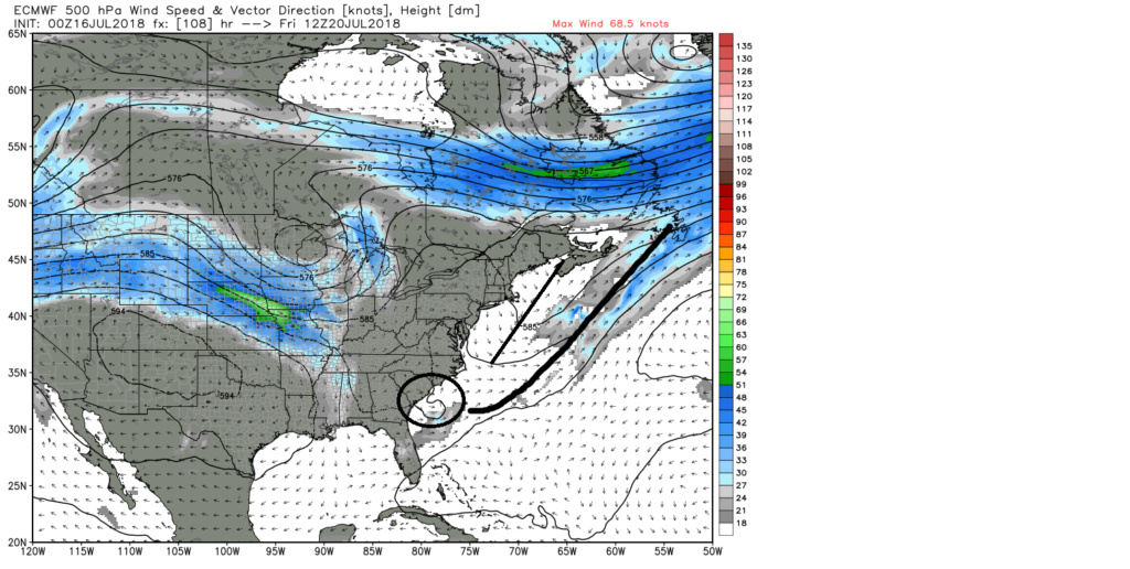
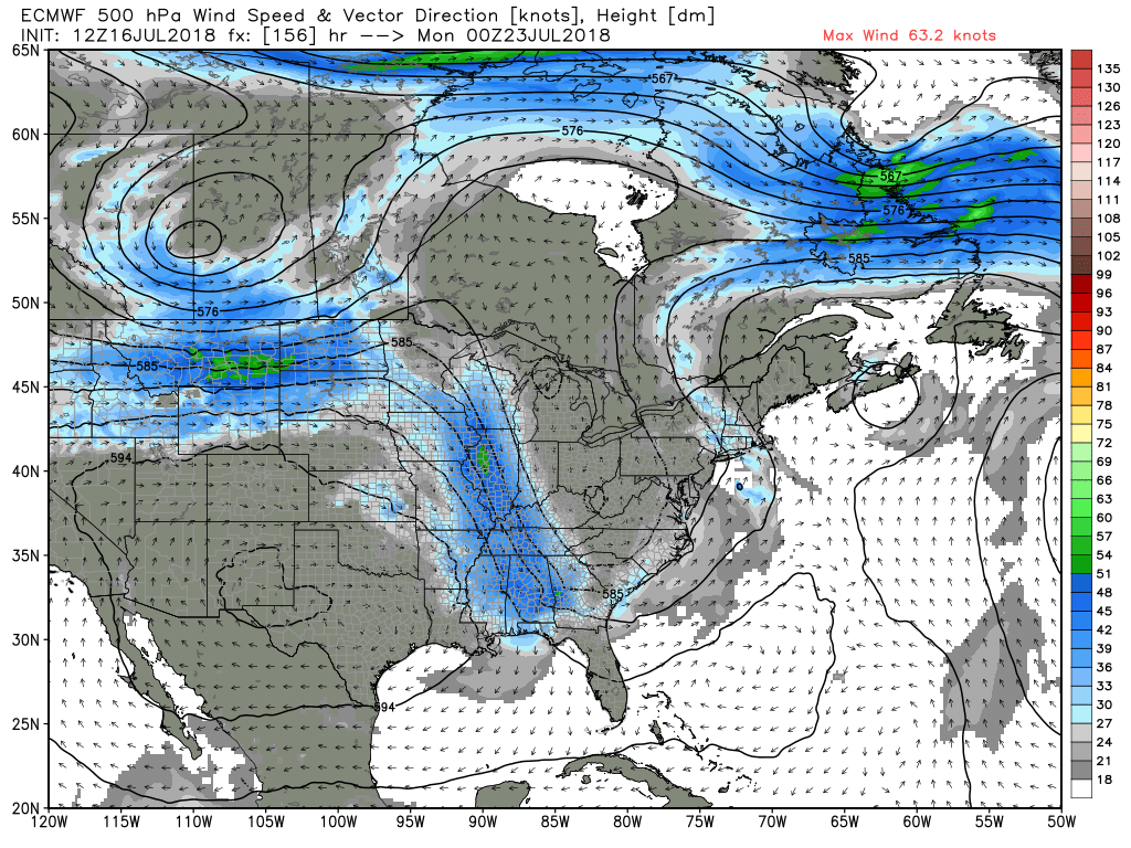
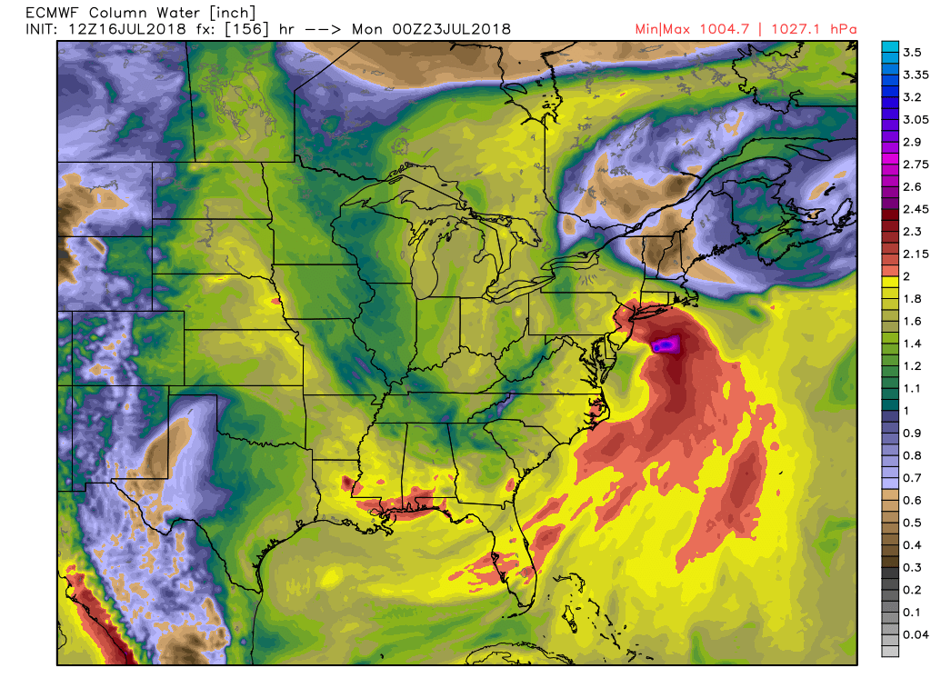
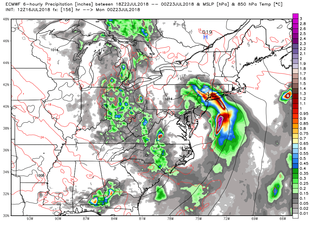
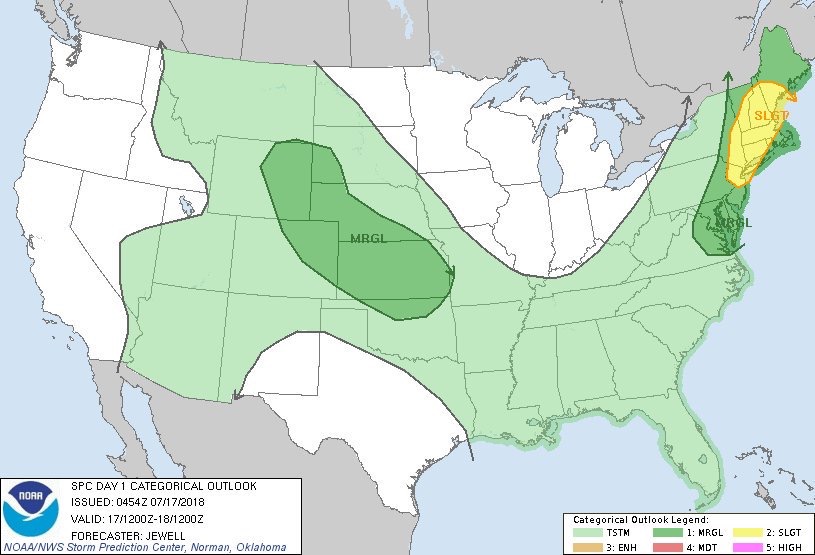
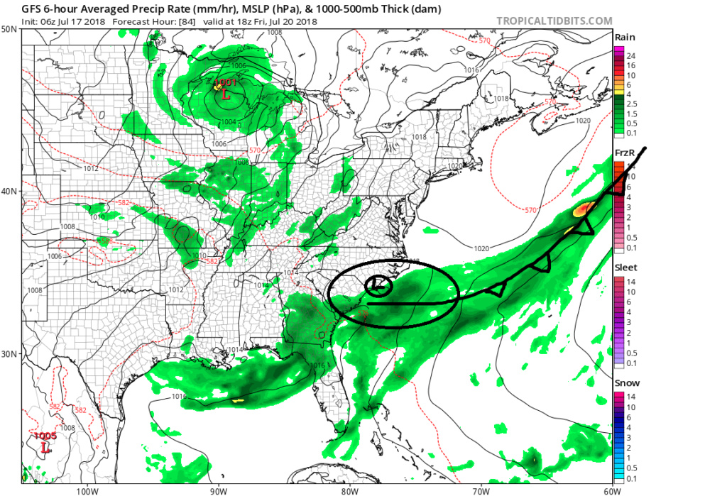
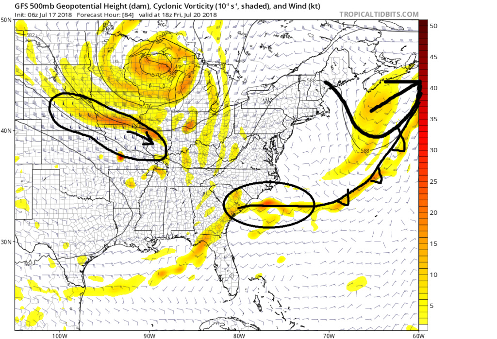
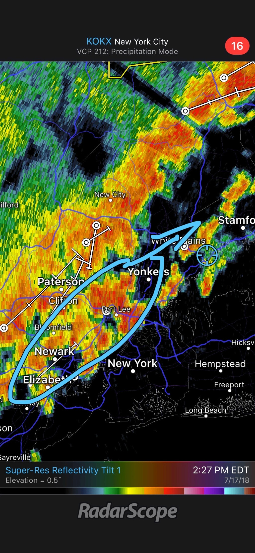
See below maps: surface, 500mb, 250mb. As you can see below by Friday, after the front that we will experience today passes, there is leftover energy sitting off the NC/SC coast at 500mb (yellow map). There is a weak surface low sitting along the coast as a result. Notice the 250mb. The arrows indicate decent outflow or upper air divergence which enhances rising air at the lower levels. as this entire feature drifts N/NE over water the water is warm enough, although not boiling by any means, to support enhancement of LP deepening. The enhanced lifting mechanisms will support thunderstorm development which could cause feedback and a warm core development. The question is how much can it deepen before it begins to interact with the approaching trough. Once that happens any warm core characteristics will quickly transitions to cold core as the trough phases with the system. Again the chances are slim for this to happen, because I don't believe there will be enough time and the SST are not quite warm enough for rapid intensification, but either way the phasing will bring very heavy rainfall and very strong gale force winds into the region for late weekend. Im almost certain of that. My initial call will be by Thursday or Friday we will see some color on the NHC site for "a small chance to develop into a trop system.

Last edited by sroc4 on Tue Jul 17, 2018 8:59 am; edited 1 time in total
_________________
"In weather and in life, there's no winning and losing; there's only winning and learning."
WINTER 2012/2013 TOTALS 43.65"WINTER 2017/2018 TOTALS 62.85" WINTER 2022/2023 TOTALS 4.9"
WINTER 2013/2014 TOTALS 64.85"WINTER 2018/2019 TOTALS 14.25" WINTER 2023/2024 TOTALS 13.1"
WINTER 2014/2015 TOTALS 71.20"WINTER 2019/2020 TOTALS 6.35"
WINTER 2015/2016 TOTALS 35.00"WINTER 2020/2021 TOTALS 37.75"
WINTER 2016/2017 TOTALS 42.25"WINTER 2021/2022 TOTALS 31.65"
sroc4- Admin
- Posts : 8441
Reputation : 302
Join date : 2013-01-07
Location : Wading River, LI
jmanley32- Senior Enthusiast
- Posts : 20635
Reputation : 108
Join date : 2013-12-12
Age : 43
Location : Yonkers, NY
Re: July 2018 Obs and Discussion
![]() by sroc4 Tue Jul 17, 2018 8:59 am
by sroc4 Tue Jul 17, 2018 8:59 am
_________________
"In weather and in life, there's no winning and losing; there's only winning and learning."
WINTER 2012/2013 TOTALS 43.65"WINTER 2017/2018 TOTALS 62.85" WINTER 2022/2023 TOTALS 4.9"
WINTER 2013/2014 TOTALS 64.85"WINTER 2018/2019 TOTALS 14.25" WINTER 2023/2024 TOTALS 13.1"
WINTER 2014/2015 TOTALS 71.20"WINTER 2019/2020 TOTALS 6.35"
WINTER 2015/2016 TOTALS 35.00"WINTER 2020/2021 TOTALS 37.75"
WINTER 2016/2017 TOTALS 42.25"WINTER 2021/2022 TOTALS 31.65"
sroc4- Admin
- Posts : 8441
Reputation : 302
Join date : 2013-01-07
Location : Wading River, LI
Re: July 2018 Obs and Discussion
![]() by jmanley32 Tue Jul 17, 2018 10:06 am
by jmanley32 Tue Jul 17, 2018 10:06 am
jmanley32- Senior Enthusiast
- Posts : 20635
Reputation : 108
Join date : 2013-12-12
Age : 43
Location : Yonkers, NY
Re: July 2018 Obs and Discussion
![]() by nutleyblizzard Tue Jul 17, 2018 11:04 am
by nutleyblizzard Tue Jul 17, 2018 11:04 am
Hope it holds off till Sunday night. Too many weekends this past spring have been washed out already.jmanley32 wrote:I'm all for a good non extreme rain and some wind storm. Beats this boring weather. What's the timeframe? Will sat into Sunday midday be okay?

nutleyblizzard- Senior Enthusiast
- Posts : 1963
Reputation : 41
Join date : 2014-01-30
Age : 58
Location : Nutley, new jersey
Re: July 2018 Obs and Discussion
![]() by jmanley32 Tue Jul 17, 2018 11:57 am
by jmanley32 Tue Jul 17, 2018 11:57 am
jmanley32- Senior Enthusiast
- Posts : 20635
Reputation : 108
Join date : 2013-12-12
Age : 43
Location : Yonkers, NY
Re: July 2018 Obs and Discussion
![]() by nutleyblizzard Tue Jul 17, 2018 12:28 pm
by nutleyblizzard Tue Jul 17, 2018 12:28 pm
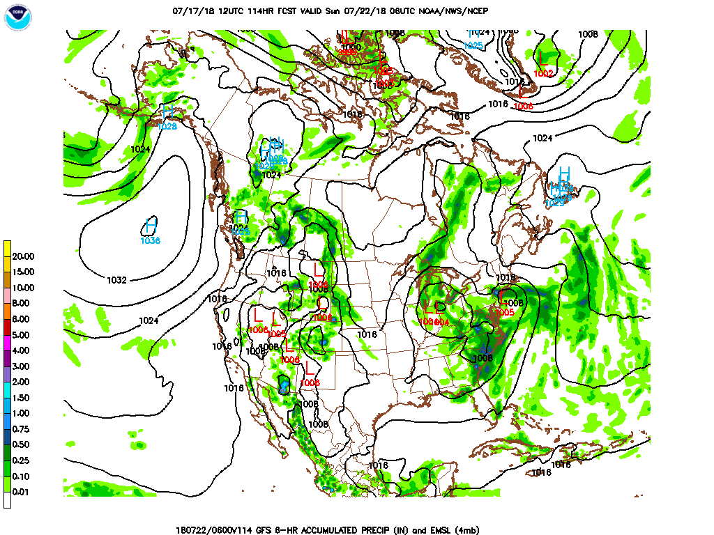 Interesting run with 12z GFS run. Shows a more consolidated/stronger tropical low development with direct impacts over our region.
nutleyblizzard- Senior Enthusiast
- Posts : 1963
Reputation : 41
Join date : 2014-01-30
Age : 58
Location : Nutley, new jersey
Re: July 2018 Obs and Discussion
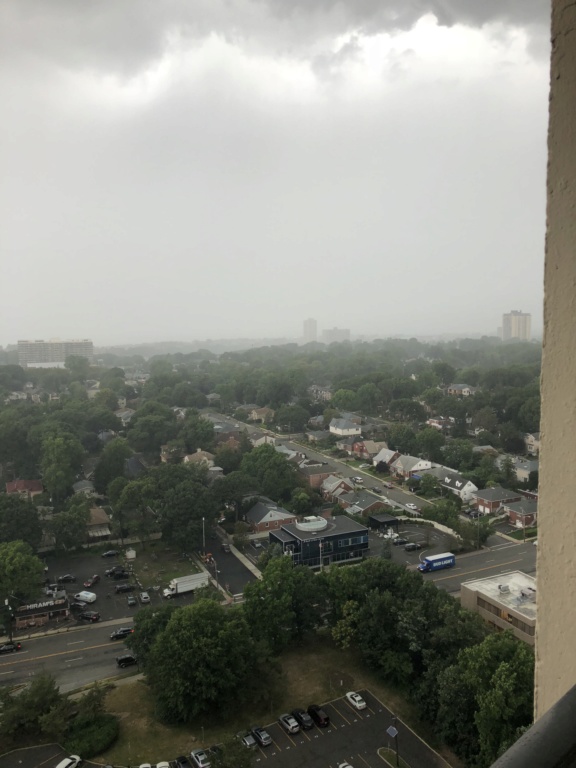
![]() by 1190ftalt Tue Jul 17, 2018 2:23 pm
by 1190ftalt Tue Jul 17, 2018 2:23 pm
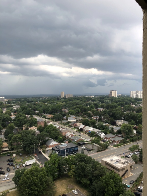
Storm in coming to Ft Lee, picture from 24 th floor looking west to Teterboro Airport ! See the rain line about 1 /2 mile !
1190ftalt- Pro Enthusiast
- Posts : 404
Reputation : 10
Join date : 2013-12-13
Location : Stillwater, NJ
Re: July 2018 Obs and Discussion
![]() by 1190ftalt Tue Jul 17, 2018 2:34 pm
by 1190ftalt Tue Jul 17, 2018 2:34 pm
1190ftalt- Pro Enthusiast
- Posts : 404
Reputation : 10
Join date : 2013-12-13
Location : Stillwater, NJ
Re: July 2018 Obs and Discussion
![]() by SoulSingMG Tue Jul 17, 2018 2:34 pm
by SoulSingMG Tue Jul 17, 2018 2:34 pm
SoulSingMG- Senior Enthusiast
- Posts : 2853
Reputation : 74
Join date : 2013-12-11
Location : Long Island City, NY
Re: July 2018 Obs and Discussion
![]() by jmanley32 Tue Jul 17, 2018 2:54 pm
by jmanley32 Tue Jul 17, 2018 2:54 pm
jmanley32- Senior Enthusiast
- Posts : 20635
Reputation : 108
Join date : 2013-12-12
Age : 43
Location : Yonkers, NY
Re: July 2018 Obs and Discussion
![]() by frank 638 Tue Jul 17, 2018 3:24 pm
by frank 638 Tue Jul 17, 2018 3:24 pm
frank 638- Senior Enthusiast
- Posts : 2862
Reputation : 37
Join date : 2016-01-01
Age : 41
Location : bronx ny
Re: July 2018 Obs and Discussion
![]() by jmanley32 Tue Jul 17, 2018 3:56 pm
by jmanley32 Tue Jul 17, 2018 3:56 pm
wasn't that bad certainly not like the ones in may.frank 638 wrote:Heavy wind-driven rain at lga all flights are grounded for now
jmanley32- Senior Enthusiast
- Posts : 20635
Reputation : 108
Join date : 2013-12-12
Age : 43
Location : Yonkers, NY
Re: July 2018 Obs and Discussion
![]() by skinsfan1177 Tue Jul 17, 2018 4:53 pm
by skinsfan1177 Tue Jul 17, 2018 4:53 pm

skinsfan1177- Senior Enthusiast
- Posts : 4485
Reputation : 35
Join date : 2013-01-07
Age : 46
Location : Point Pleasant Boro
Re: July 2018 Obs and Discussion
![]() by Vinnydula Tue Jul 17, 2018 7:24 pm
by Vinnydula Tue Jul 17, 2018 7:24 pm

Vinnydula- Pro Enthusiast
- Posts : 778
Reputation : 8
Join date : 2013-12-12
Location : Dobbs ferry
Re: July 2018 Obs and Discussion
![]() by jmanley32 Tue Jul 17, 2018 8:41 pm
by jmanley32 Tue Jul 17, 2018 8:41 pm
Speaking of the possible system this weekend 18z GFS has a fully close LP and it tries to develop before turning into the area, this should be interesting to watch if it happens.
jmanley32- Senior Enthusiast
- Posts : 20635
Reputation : 108
Join date : 2013-12-12
Age : 43
Location : Yonkers, NY
Page 3 of 7 • 1, 2, 3, 4, 5, 6, 7 ![]()
|
|
|