2018 Hurricane Season
+26
Vinnydula
Math23x7
bobjohnsonforthehall
larryrock72
oldtimer
Grselig
billg315
Joe Snow
nutleyblizzard
Radz
Frank_Wx
jwalsh
Sanchize06
Dunnzoo
weatherwatchermom
rb924119
algae888
frank 638
skinsfan1177
amugs
GreyBeard
SoulSingMG
Quietace
Snow88
sroc4
jmanley32
30 posters
Page 3 of 18
Page 3 of 18 •  1, 2, 3, 4 ... 10 ... 18
 Re: 2018 Hurricane Season
weatherwatchermom wrote:I have a friend who is in Hawaii on vacation!!!!!!!

My friend just came back last weekend.. close call!Can't imagine what they are going through..
Last edited by Dunnzoo on Fri Aug 24, 2018 7:38 pm; edited 1 time in total
Dunnzoo- Senior Enthusiast - Mod

- Posts : 4904
Join date : 2013-01-11
 Re: 2018 Hurricane Season
31 inches or rain and rising!! Holy smokes, just heard this about Hawaii. What caused the strange track of the hurricane to hook due north, I do not think I have ever seen that. I am guessing this is a pretty rare occurrence for Hawaii?
jmanley32- Senior Enthusiast

- Posts : 20535
Join date : 2013-12-12
 Re: 2018 Hurricane Season
jmanley32 wrote:31 inches or rain and rising!! Holy smokes, just heard this about Hawaii. What caused the strange track of the hurricane to hook due north, I do not think I have ever seen that. I am guessing this is a pretty rare occurrence for Hawaii?
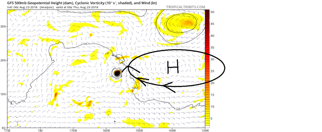
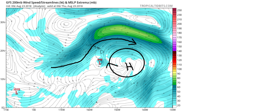
Its not that rare. The biggest problem with the rain is the upsloping due to the topography of the islands. Enhanced lift = enhances rainfall. Here is the reason for the track. For the most part is was rounding a ridge at both 500mb and 200mb. Follow the wind barbs
_________________
"In weather and in life, there's no winning and losing; there's only winning and learning."
WINTER 2012/2013 TOTALS 43.65"WINTER 2017/2018 TOTALS 62.85" WINTER 2022/2023 TOTALS 4.9"
WINTER 2013/2014 TOTALS 64.85"WINTER 2018/2019 TOTALS 14.25" WINTER 2023/2024 TOTALS 13.1"
WINTER 2014/2015 TOTALS 71.20"WINTER 2019/2020 TOTALS 6.35"
WINTER 2015/2016 TOTALS 35.00"WINTER 2020/2021 TOTALS 37.75"
WINTER 2016/2017 TOTALS 42.25"WINTER 2021/2022 TOTALS 31.65"

sroc4- Admin

- Posts : 8354
Reputation : 302
Join date : 2013-01-07
Location : Wading River, LI
 Re: 2018 Hurricane Season
Looks like it is really weakening. People hanging out on the beach at Waikiki, sun was out, no waves of any distinction. They are saying will be downgraded to a tropical storm by tomorrow. No doubt some places got tons of rain, with more to come, but looks like they dodged the bullet as far as getting a direct hit. Winds pretty much sheared it apart.
GreyBeard- Senior Enthusiast

- Posts : 725
Reputation : 34
Join date : 2014-02-12
Location : eastern nassau county
 Re: 2018 Hurricane Season
A huge shift is occurring in the large scale global wind pattern forecast. Below I am posting the 200 Hpa or 200mb (Approx 32,000ft above sea level), wind patterns. When air at the surface converges it can't go down through the ground so is forced to rise giving way to low pressure. However; in the upper levels the opposite is true. The orange colors depict air that is converging(coming together at a center point); whereas the green colors depict air that is diverging(moving away from a center point). At this altitude picture on a large scale winds coming together horizontally, convergence, over areas in orange. When the air from the west meets the air from the east it crashes into each other and the air molecules are forced downward, so sinking air or subsidence. Flip the coin...picture the air at 32k ft moving away from a center point, divergence. In order to replace the air molecules spreading apart horizontally, air beneath it is forced to rise up to replace it, convection.
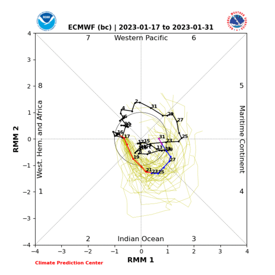
First image is week 1 forecast, Aug 27th -Sept 3rd. Second image is week 2, Sept3rd-- Sept 11th. Notice the big picure pattern in week one is to have the convergence zone over the Trop pacific and the divergent zone over the Trop Atlantic. However in week two that appears to be shifting. Look just how strong the areas of orange are over the Western Pac and the greens become over the eastern Pac and Atlantic. This means that lower pressures will be favored in areas of green.
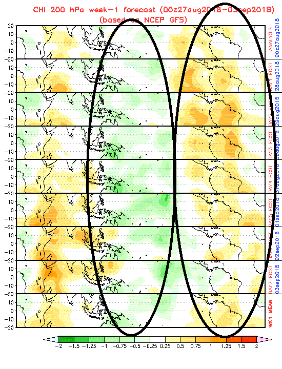

More simply stated if there are tropical waves traversing the lower levels of the atmosphere beneath the areas in green the upper levels will be more conducive for trop development. Trop waves up through this point and through week one forecast have traversed under the areas of orange meaning that the air above them has been sinking; which is NOT favorable for trop development. What this means is that the Atlantic is coming to life folks if this forecast is true. Now just because the upper levels are becoming more favorable this doesn't mean a guarantee for development, but its a start. The Eastern Pac seems to show the strongest areas of upper level divergence so it may steal the thunder for development. But given this upper level pattern the modeling, as its just starting to do, will def start producing trop systems in the long range. Keep this in mind. I posted these maps a few days ago and the forecast was drastically different. This is because the MJO forecast was drastically different a few days ago. I also pointed out in my discussion a few days ago that the MJO forecast had been doing some weird things. Prev the forecast was to take the MJO wave out into phase 4-5 with at least some amplitude; however, the forecasted amplitude into these phases has trended weaker and weaker and now as you can see the forecast now has it coming out in phase 8-1 and possibly never coming out of the null phase at all before doing so. This is drastically diffenet than just a few days ago where it still had the MJO coming out into phases 4/5. This is likely the big difference in the flipping of the 200mb forecast maps I posted above. We will have to see how this all plays out. I still think it takes a little longer than whatis modeled to really get things going. Ray(rb) stated first half of Sept and I stated second half. The things look it appears that mid sept we will get a trop system to track towards the mainland which means we were both correct in the analysis, but we simply came at it from slightly diff angles.

First image is week 1 forecast, Aug 27th -Sept 3rd. Second image is week 2, Sept3rd-- Sept 11th. Notice the big picure pattern in week one is to have the convergence zone over the Trop pacific and the divergent zone over the Trop Atlantic. However in week two that appears to be shifting. Look just how strong the areas of orange are over the Western Pac and the greens become over the eastern Pac and Atlantic. This means that lower pressures will be favored in areas of green.


More simply stated if there are tropical waves traversing the lower levels of the atmosphere beneath the areas in green the upper levels will be more conducive for trop development. Trop waves up through this point and through week one forecast have traversed under the areas of orange meaning that the air above them has been sinking; which is NOT favorable for trop development. What this means is that the Atlantic is coming to life folks if this forecast is true. Now just because the upper levels are becoming more favorable this doesn't mean a guarantee for development, but its a start. The Eastern Pac seems to show the strongest areas of upper level divergence so it may steal the thunder for development. But given this upper level pattern the modeling, as its just starting to do, will def start producing trop systems in the long range. Keep this in mind. I posted these maps a few days ago and the forecast was drastically different. This is because the MJO forecast was drastically different a few days ago. I also pointed out in my discussion a few days ago that the MJO forecast had been doing some weird things. Prev the forecast was to take the MJO wave out into phase 4-5 with at least some amplitude; however, the forecasted amplitude into these phases has trended weaker and weaker and now as you can see the forecast now has it coming out in phase 8-1 and possibly never coming out of the null phase at all before doing so. This is drastically diffenet than just a few days ago where it still had the MJO coming out into phases 4/5. This is likely the big difference in the flipping of the 200mb forecast maps I posted above. We will have to see how this all plays out. I still think it takes a little longer than whatis modeled to really get things going. Ray(rb) stated first half of Sept and I stated second half. The things look it appears that mid sept we will get a trop system to track towards the mainland which means we were both correct in the analysis, but we simply came at it from slightly diff angles.


_________________
"In weather and in life, there's no winning and losing; there's only winning and learning."
WINTER 2012/2013 TOTALS 43.65"WINTER 2017/2018 TOTALS 62.85" WINTER 2022/2023 TOTALS 4.9"
WINTER 2013/2014 TOTALS 64.85"WINTER 2018/2019 TOTALS 14.25" WINTER 2023/2024 TOTALS 13.1"
WINTER 2014/2015 TOTALS 71.20"WINTER 2019/2020 TOTALS 6.35"
WINTER 2015/2016 TOTALS 35.00"WINTER 2020/2021 TOTALS 37.75"
WINTER 2016/2017 TOTALS 42.25"WINTER 2021/2022 TOTALS 31.65"

sroc4- Admin

- Posts : 8354
Reputation : 302
Join date : 2013-01-07
Location : Wading River, LI
 Re: 2018 Hurricane Season
The past two runs of the Euro have a hurricane in the Gulf in the six to seven day time frame

algae888- Advanced Forecaster

- Posts : 5311
Reputation : 46
Join date : 2013-02-05
Age : 62
Location : mt. vernon, new york
 Re: 2018 Hurricane Season
The Euro has 3 systems in the central and eastern atlantic while the other models have nothing. The gulf system is nothing but a TD if that, I did not see it ever low enough on the euro to be a hurricane Al but maybe I missed that. Needless to say IF the Euro is right the next few weeks will be interesting, wonder if there may be a uptick in the forecast if we continue to show this amount of activity going forward, that is IF it transpires. Euro has been wrong many times.
My bad 995mb, yeah prolly low enough for minimal hurricane.
My bad 995mb, yeah prolly low enough for minimal hurricane.

jmanley32- Senior Enthusiast

- Posts : 20535
Reputation : 108
Join date : 2013-12-12
Age : 43
Location : Yonkers, NY
 Re: 2018 Hurricane Season
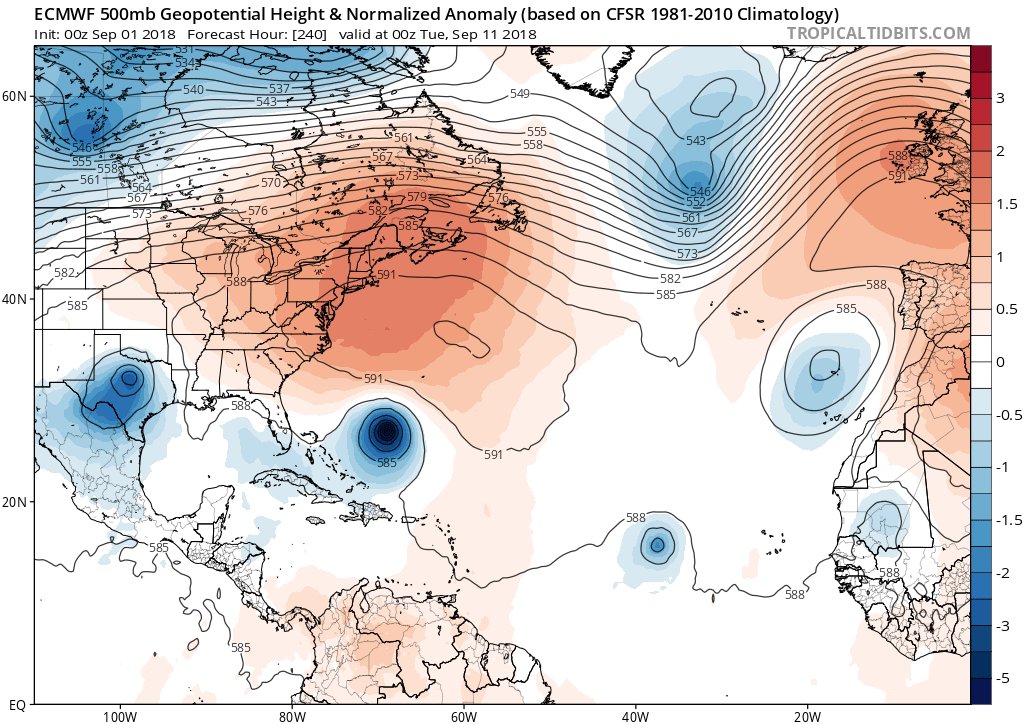
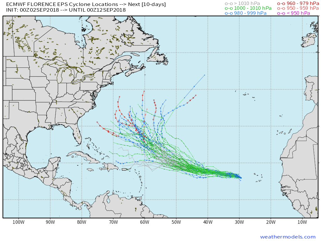
This upcoming pattern warrants the attention of people up and down the East Coast. 00z EPS says not to write off prospective Florence so quickly as a curver. 

SoulSingMG- Senior Enthusiast

- Posts : 2853
Reputation : 74
Join date : 2013-12-11
Location : Long Island City, NY
 Re: 2018 Hurricane Season
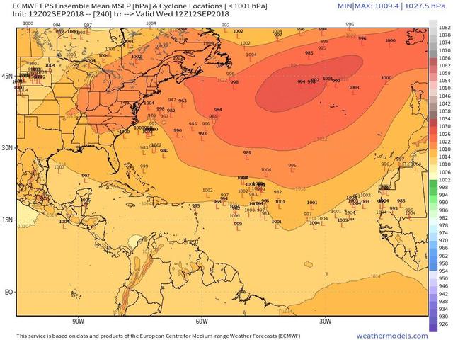
Do you have a image of the low placements? I no longer have a subscription that lets me look at Euro, so anyone can post the Euro through the season it would be great.SoulSingMG wrote:This upcoming pattern warrants the attention of people up and down the East Coast. 00z EPS says not to write off prospective Florence so quickly as a curver.

jmanley32- Senior Enthusiast

- Posts : 20535
Reputation : 108
Join date : 2013-12-12
Age : 43
Location : Yonkers, NY
 Re: 2018 Hurricane Season
06z GFS long range has a very odd track ending it up on a west or slightly SW track towards new england or midatlantic, really weird track and as a 962mb hurricane at that latitude, way crazy. It will change a million times and as I know Al says tracking these things is so tedious cuz they take forever lol, but it is so true, I will not be checking in on to be Florence too much till it either recurves or it pulls a western turn.

jmanley32- Senior Enthusiast

- Posts : 20535
Reputation : 108
Join date : 2013-12-12
Age : 43
Location : Yonkers, NY
 Re: 2018 Hurricane Season
Well, it is September, almost the peak of the Atlantic season. So yes, most people that live on the coast should keep an eye on the tropics. In terms of PT6/whatever the hell you want to call it, do you know what quantile Florence would be in if it didn't recurve? I place my bets that it does for a variety of reasons that support a general poleward bias in movement.SoulSingMG wrote:This upcoming pattern warrants the attention of people up and down the East Coast. 00z EPS says not to write off prospective Florence so quickly as a curver.

Quietace- Meteorologist - Mod

- Posts : 3689
Reputation : 33
Join date : 2013-01-07
Age : 27
Location : Point Pleasant, NJ
 Re: 2018 Hurricane Season
I will add though that if this never forms, the steering layer would be sufficiently low enough that this could head more westerly initially rather than poleward. However, it would be extremely unlikely that it would transverse the Atlantic for 5+ days without a interaction with a trough to lift it north.SoulSingMG wrote:This upcoming pattern warrants the attention of people up and down the East Coast. 00z EPS says not to write off prospective Florence so quickly as a curver.

Quietace- Meteorologist - Mod

- Posts : 3689
Reputation : 33
Join date : 2013-01-07
Age : 27
Location : Point Pleasant, NJ
 Re: 2018 Hurricane Season
40% chance of TC formation in the gulf over the next 5-days. Highest threat is likely the Central Gulf coast as the waves movements is more WNW than NW.

Quietace- Meteorologist - Mod

- Posts : 3689
Reputation : 33
Join date : 2013-01-07
Age : 27
Location : Point Pleasant, NJ

skinsfan1177- Senior Enthusiast

- Posts : 4485
Reputation : 35
Join date : 2013-01-07
Age : 46
Location : Point Pleasant Boro
 Re: 2018 Hurricane Season
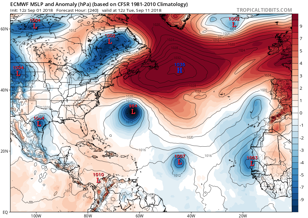
12z has Florence further north headed towards carolinas, midatlantic, if the high were in that position above it would have no choice but to go west. But as Ace said this would be highly against the recurve rule. But theres always surprises in the tropics.
Look at the position of the HP, thats going west or WNW. Bout not taking anything to any thought, currently NHC is saying the recurve.
Look at the position of the HP, thats going west or WNW. Bout not taking anything to any thought, currently NHC is saying the recurve.


jmanley32- Senior Enthusiast

- Posts : 20535
Reputation : 108
Join date : 2013-12-12
Age : 43
Location : Yonkers, NY
 Re: 2018 Hurricane Season
The GFS has Florence re-curve while the EC suggests its poleward movement is inhibited by a UL ridge and is steered towards the US. As seen with the EPS below, there is rather large spread (as expected at day 10) between members once we get to about 50/20 (as that is where ML flow begins to interact with Florence). Most members suggest some sort of re-curve, though, given the current time-frame (7+ days), I can not rule out the EC operationals projection.


Quietace- Meteorologist - Mod

- Posts : 3689
Reputation : 33
Join date : 2013-01-07
Age : 27
Location : Point Pleasant, NJ

skinsfan1177- Senior Enthusiast

- Posts : 4485
Reputation : 35
Join date : 2013-01-07
Age : 46
Location : Point Pleasant Boro
 Re: 2018 Hurricane Season
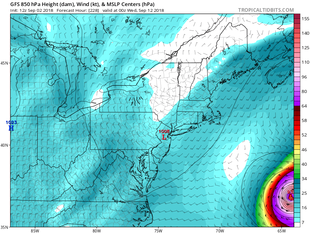
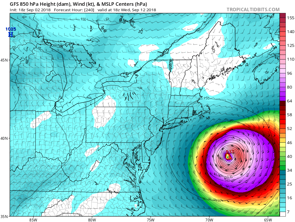
GFS does have a recurve but having a 937mb cat 5 several hundred miles offshore before the turn is just a but unerving f that were to happen, what strengthens Florence so much (given the models not the actuality) to that intensity so far north? I tell you if that UL ridge does NOT move out as fast as shown this could be hisotric in a track for a hurricane to hit the midatlantic northeast from that angle, i think something similar has happened before but it sure is rare like ace said the recurve is most likely but who thought a situation like sandy would happen (and my god a cat 5 would be so far worse than sandy, can u even imagine yikes.

jmanley32- Senior Enthusiast

- Posts : 20535
Reputation : 108
Join date : 2013-12-12
Age : 43
Location : Yonkers, NY
 Re: 2018 Hurricane Season
Ahh I see the waters are super warm all across central atlantic and even up the coast to southern jersey thats crazy and bad, if anything were to threaten the area water would not be a weakening factor
12z CMC has landfall and curve up EC at day 10 carolinas then north.
12z CMC has landfall and curve up EC at day 10 carolinas then north.

jmanley32- Senior Enthusiast

- Posts : 20535
Reputation : 108
Join date : 2013-12-12
Age : 43
Location : Yonkers, NY
 Re: 2018 Hurricane Season
12z Euro is much further south and will make a EC landfall on this run and likely ride the coast. Yikes 955mb at OBX and headed up coast jesus, luckily its 10 days out so we really got no clue what will transpire but it looks like GFS and Euro and CMC all want to keep this from recurving and getting it to or vary close to carolinas or further north. Yes GFS does recurve it but its much closer to euro and CMC than it was days ago. And I am surprised at the decent consistency from all 3 models.

jmanley32- Senior Enthusiast

- Posts : 20535
Reputation : 108
Join date : 2013-12-12
Age : 43
Location : Yonkers, NY
 Re: 2018 Hurricane Season
JB of course tweeting away already:
Boiling SST off coast will help pump ridge NEXT week, FLORENCE bust Central Atlantic trof, turn back west ,become major hurricane, with threat to east coast Sept 12-16. Pattern identified in May Less intensity in deep tropics, more n/w All hail JMA 10 days ago catching pattern!
Question is the scroll for this week or is it old? Are we having another heat wave"\?

jmanley32- Senior Enthusiast

- Posts : 20535
Reputation : 108
Join date : 2013-12-12
Age : 43
Location : Yonkers, NY

skinsfan1177- Senior Enthusiast

- Posts : 4485
Reputation : 35
Join date : 2013-01-07
Age : 46
Location : Point Pleasant Boro
 Re: 2018 Hurricane Season
18z GFS continues the trend of a weaker system in the short term, which keeps it further south and avoids being re curved out. Should be interesting to see how close it gets
Sanchize06- Senior Enthusiast

- Posts : 1041
Reputation : 21
Join date : 2013-02-05
Location : Union Beach, NJ
 Re: 2018 Hurricane Season
Still re-curves OTS, but definitely closer again
Sanchize06- Senior Enthusiast

- Posts : 1041
Reputation : 21
Join date : 2013-02-05
Location : Union Beach, NJ
 Re: 2018 Hurricane Season
Jesus 18z GFS 933mb cat 4/5 just several hundred miles offshore, I think this def warrents come concern for the EC if these trends continue, Ace you might have to kick the norm of a quick recurve out this time. But you are right, thats usually what happens. What I find interesting is GFS is NOT picking up on much of anything for gulf, yet TS watches just went up. I would love to hear some indepth analysis from ray, Frank, scott on if they believe the system being suppressed on a western track and barely recurving in time or making a serriously bad landfall.
WOW....
WOW....


jmanley32- Senior Enthusiast

- Posts : 20535
Reputation : 108
Join date : 2013-12-12
Age : 43
Location : Yonkers, NY

jmanley32- Senior Enthusiast

- Posts : 20535
Reputation : 108
Join date : 2013-12-12
Age : 43
Location : Yonkers, NY
 Re: 2018 Hurricane Season
Don’t go too crazy over model solns for tropical systems 240 hrs out. Models often don’t know how to handle them in 3-5 days or less let alone 7-10. Give it 3-5 days then let’s see where we stand with Florence. For now focus should be on the tropical wave north of Cuba.
_________________
"In weather and in life, there's no winning and losing; there's only winning and learning."
WINTER 2012/2013 TOTALS 43.65"WINTER 2017/2018 TOTALS 62.85" WINTER 2022/2023 TOTALS 4.9"
WINTER 2013/2014 TOTALS 64.85"WINTER 2018/2019 TOTALS 14.25" WINTER 2023/2024 TOTALS 13.1"
WINTER 2014/2015 TOTALS 71.20"WINTER 2019/2020 TOTALS 6.35"
WINTER 2015/2016 TOTALS 35.00"WINTER 2020/2021 TOTALS 37.75"
WINTER 2016/2017 TOTALS 42.25"WINTER 2021/2022 TOTALS 31.65"

sroc4- Admin

- Posts : 8354
Reputation : 302
Join date : 2013-01-07
Location : Wading River, LI
Page 3 of 18 •  1, 2, 3, 4 ... 10 ... 18
Page 3 of 18
Permissions in this forum:
You cannot reply to topics in this forum|
|
|

 Home
Home