Long Range Thread 17.0
+40
Radz
lglickman1
Wheezer
aiannone
heehaw453
SENJsnowman
Scullybutcher
jake732
Sanchize06
larryrock72
bobjohnsonforthehall
SnowForest
hyde345
SoulSingMG
weatherwatchermom
MattyICE
GreyBeard
Smittyaj623
HectorO
Vinnydula
Nyi1058
jmanley32
CPcantmeasuresnow
Dunnzoo
algae888
skinsfan1177
Snow88
Quietace
rb924119
dkodgis
sroc4
docstox12
Grselig
amugs
Math23x7
billg315
nutleyblizzard
frank 638
mwilli5783
Frank_Wx
44 posters
Page 3 of 41
Page 3 of 41 •  1, 2, 3, 4 ... 22 ... 41
 Re: Long Range Thread 17.0
In general by what approx date is the first frost? I have a selfish reason. I want to get rid of crab grass.
dkodgis- Senior Enthusiast

- Posts : 2661
Join date : 2013-12-29
 Re: Long Range Thread 17.0
Michael Ventrice is saying how the Euro will be running 4 times a day soon
Snow88- Senior Enthusiast

- Posts : 2193
Join date : 2013-01-09
 Re: Long Range Thread 17.0
Great news!!!Snow88 wrote:Michael Ventrice is saying how the Euro will be running 4 times a day soon

nutleyblizzard- Senior Enthusiast

- Posts : 1963
Reputation : 41
Join date : 2014-01-30
Age : 58
Location : Nutley, new jersey
 Re: Long Range Thread 17.0
Frank_Wx wrote:Frank_Wx wrote:Piggy-backing off my posts above the models continue to show what would be a blast of fall-like temps into the area late September into early October. The -EPO/+PNA forces a trough over the east.
GEFS September 29th:
GEFS October 3rd
The EPS are in agreement
It will be interesting to see how long the trough will hold over the east. I think the period between September 28th (+/- 2 days) and October 4th (+/- 2 days) will feature below normal temps. How long it lasts remains to be seen. Most likely, this time of year, it is transient.
Revisiting this post because there are clear signs at this lead time that the cold will not be as pronounced as originally thought.
As Scott mentioned there is a -PNA as opposed to the +PNA models were showing at that time. Here is the same time stamp for the 29th on today's GEFS:
The trough is clearly there in southern Canada but there is no mechanism to drop it south into our region. The warm SSTA's in the Atlantic this time of year will give the SE Ridge or WAR more power than any early-reason trough that tries to come this way.
The GEFS and EPS suggest we'll remain above normal temperatures through the first week of October.
Honestly not a whole lot happening weather-wise in the long range.
MJO phases 8-3 fight eastern CONUS troughing this time of year. Check out the current MJO progs
Honestly, fine by me. Transience this time of year is fine; save the locked patterns for true winter haha
Last edited by rb924119 on Thu Sep 27, 2018 2:02 pm; edited 1 time in total
rb924119- Meteorologist

- Posts : 7033
Reputation : 195
Join date : 2013-02-06
Age : 32
Location : Greentown, Pa
 Re: Long Range Thread 17.0
nutleyblizzard wrote:RB I would not put much credence with Nino 1.2 currently being warmer than 3.4. 1.2 has a known bias of being volatile with surface temps in a week to week basis. There is subsurface warmth in 3.4 that will influence that region in the coming days and weeks. Also there is no model guidance suggesting an eastern Nino developing this fall and winter. I do agree regardless of what happens this Nino will most likely be a weak one which will make other weather parameters come to the fore front. The warm blob in the northern Pacific will promote ridging out west which will ensure a trough in the east. Things look to line up in the Atlantic as well as we have a favorable QBO along with a solar minimum which both will help promote a -NAO and -AO. The only fly in the ointment is a stubborn western Atlantic ridge that remains persistently strong. All in all I'm very confident of an upcoming cold and snowy winter.
Exactly the reason why I said "if these conditions held verbatim through the Winter" haha you are quite correct about how volatile 1.2 is. However, be careful when looking at model guidance, as it's been proven to be shaky, at best. Remember last year? Up until August we were in line for another Niño event. What happened? Niña. However, I agree that the upcoming and current SOI crash and current SST anomaly configurations will constructively interfere such that warm-neutral or weak Niño conditions do result, but recent warming of the western tropical Atlantic has slowed the easterlies around western South America via alteration of the ambient pressure patterns against the base state, which is now located in the heart of the large-scale ascent instead of on the eastern periphery. Therefore, upwelling has temporarily ceased.
The Pacific "blob" will definitely assist our cause, but we will still need help from other factors to "ensure" time-mean troughing in the East, as you correctly stated, the western Atlantic warmth will continue to aid in bolstering ridging. The QBO while negative, is trending positive and is expected to continue to do so in coming months. Just how quickly and how much it changes over the next couple months will help us to see what it's lagged effects are as we get into winter. However, just because it's negative, it does not necessarily lock in Atlantic blocking with any "staying power". An additional factor to consider in this region is the configuration and degree of SST anomalies and their possible impacts on the lower- to mid-tropospheric flow. At present, a time-mean positive NAO state is strongly favored (when only this factor is considered), as the current SST configuration would help to enhance thermal potential energy/baroclinicity, and thus, strengthen the jet coming off of eastern North America, and making it resilient to alterations (buckling).
While all of this sounds negative, I am simply trying to point out everything that's on the table openly, and view both sides of the coin. I am no long-range or seasonal expert, and have never issued a seasonal outlook before, but when considering one, you must be acutely aware of ALL factors and then try to weight them and their effects the best you can.
rb924119- Meteorologist

- Posts : 7033
Reputation : 195
Join date : 2013-02-06
Age : 32
Location : Greentown, Pa
 Re: Long Range Thread 17.0
Just got word that the EURO will run 4 times per day starting October 1st.

nutleyblizzard- Senior Enthusiast

- Posts : 1963
Reputation : 41
Join date : 2014-01-30
Age : 58
Location : Nutley, new jersey
 Re: Long Range Thread 17.0
Twc has posted there fall and early winter Outlook I am not too happy for what they are saying . For October we will have below normal for temperature wise then as we get into November and December they are saying temperatures are going to be average to slightly above-average for the Northeast
frank 638- Senior Enthusiast

- Posts : 2861
Reputation : 37
Join date : 2016-01-01
Age : 41
Location : bronx ny
 Re: Long Range Thread 17.0
frank 638 wrote:Twc has posted there fall and early winter Outlook I am not too happy for what they are saying . For October we will have below normal for temperature wise then as we get into November and December they are saying temperatures are going to be average to slightly above-average for the Northeast
Long range guidance already shows the forecast for half the month of October.
Average 2M Temps OCT 1st-6th:

OCT 5th-10th:
https://www.tropicaltidbits.com/analysis/models/gfs-ens/2018092800/gfs-ens_T2maMean_namer_8.png
OCT 9th-12th:

The eastern CONUS is under warm temp anomalies. I do not see how OCT finishes below normal. I would not put a lot of stock into what they say...

_________________
_______________________________________________________________________________________________________
CLICK HERE to view NJ Strong Snowstorm Classifications
 Re: Long Range Thread 17.0
Lol thanks Frank as we say in Italian silenzio
frank 638- Senior Enthusiast

- Posts : 2861
Reputation : 37
Join date : 2016-01-01
Age : 41
Location : bronx ny
 Re: Long Range Thread 17.0
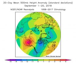
World Climate Service reported the Alaskan blocking the first 20 days of September was the strongest on record:
https://twitter.com/WorldClimateSvc/status/1045015726183133185
All this cross-polar blocking is expected to remain in place through the first 7-10 days of October.

Seems like the Stratospheric PV will be in a weak state early on. A weak PV raises the probability of a Sudden Stratospheric Warming Event. It's not guaranteed, unfortunately.

https://twitter.com/WorldClimateSvc/status/1045015726183133185
All this cross-polar blocking is expected to remain in place through the first 7-10 days of October.

Seems like the Stratospheric PV will be in a weak state early on. A weak PV raises the probability of a Sudden Stratospheric Warming Event. It's not guaranteed, unfortunately.
_________________
_______________________________________________________________________________________________________
CLICK HERE to view NJ Strong Snowstorm Classifications
 Re: Long Range Thread 17.0
Frank_Wx wrote:World Climate Service reported the Alaskan blocking the first 20 days of September was the strongest on record:
https://twitter.com/WorldClimateSvc/status/1045015726183133185
All this cross-polar blocking is expected to remain in place through the first 7-10 days of October.
Seems like the Stratospheric PV will be in a weak state early on. A weak PV raises the probability of a Sudden Stratospheric Warming Event. It's not guaranteed, unfortunately.
Another piece in the puzzle that I referenced in my earlier posts regarding a more substantial pattern change
I will likely have a write-up or video at some point this weekend outlining my thoughts, for those interested.
rb924119- Meteorologist

- Posts : 7033
Reputation : 195
Join date : 2013-02-06
Age : 32
Location : Greentown, Pa
 Re: Long Range Thread 17.0
Latest ENSO weeklies are in. El Nino starting to take hold. Nino 1+2 -0.3 Nino 3 0.6 Nino 3.4 0.6 Nino 4 0.6
Last edited by nutleyblizzard on Tue Oct 02, 2018 6:51 am; edited 1 time in total

nutleyblizzard- Senior Enthusiast

- Posts : 1963
Reputation : 41
Join date : 2014-01-30
Age : 58
Location : Nutley, new jersey
 Re: Long Range Thread 17.0
Euro now runs 4 times a day

Snow88- Senior Enthusiast

- Posts : 2193
Reputation : 4
Join date : 2013-01-09
Age : 36
Location : Brooklyn, NY
 Re: Long Range Thread 17.0
Its not on tropical tidbits. I guess you need to have a subscription to see it. bummer.Snow88 wrote:Euro now runs 4 times a day

nutleyblizzard- Senior Enthusiast

- Posts : 1963
Reputation : 41
Join date : 2014-01-30
Age : 58
Location : Nutley, new jersey
 Re: Long Range Thread 17.0
nutleyblizzard wrote:Its not on tropical tidbits. I guess you need to have a subscription to see it. bummer.Snow88 wrote:Euro now runs 4 times a day
So far that Ive seen the Storm Vista site does currently carry the euro's new 06z and 18z runs; however, it is not curently on the Weather Bell site. I emailed WB this am to see if they can give me any info on when of if they will carry the 06z and 18z runs. If anyone has any additional info on which sites will have it and when Id appreciate it. Thanks
_________________
"In weather and in life, there's no winning and losing; there's only winning and learning."
WINTER 2012/2013 TOTALS 43.65"WINTER 2017/2018 TOTALS 62.85" WINTER 2022/2023 TOTALS 4.9"
WINTER 2013/2014 TOTALS 64.85"WINTER 2018/2019 TOTALS 14.25" WINTER 2023/2024 TOTALS 13.1"
WINTER 2014/2015 TOTALS 71.20"WINTER 2019/2020 TOTALS 6.35"
WINTER 2015/2016 TOTALS 35.00"WINTER 2020/2021 TOTALS 37.75"
WINTER 2016/2017 TOTALS 42.25"WINTER 2021/2022 TOTALS 31.65"

sroc4- Admin

- Posts : 8441
Reputation : 302
Join date : 2013-01-07
Location : Wading River, LI
 Re: Long Range Thread 17.0
Some signs are pointing toward a cool last week of October, but man oh man it looks quite toasty relative to normal this time of year the first 2-3 weeks
_________________
_______________________________________________________________________________________________________
CLICK HERE to view NJ Strong Snowstorm Classifications
 Re: Long Range Thread 17.0
_________________
"In weather and in life, there's no winning and losing; there's only winning and learning."
WINTER 2012/2013 TOTALS 43.65"WINTER 2017/2018 TOTALS 62.85" WINTER 2022/2023 TOTALS 4.9"
WINTER 2013/2014 TOTALS 64.85"WINTER 2018/2019 TOTALS 14.25" WINTER 2023/2024 TOTALS 13.1"
WINTER 2014/2015 TOTALS 71.20"WINTER 2019/2020 TOTALS 6.35"
WINTER 2015/2016 TOTALS 35.00"WINTER 2020/2021 TOTALS 37.75"
WINTER 2016/2017 TOTALS 42.25"WINTER 2021/2022 TOTALS 31.65"

sroc4- Admin

- Posts : 8441
Reputation : 302
Join date : 2013-01-07
Location : Wading River, LI
 Re: Long Range Thread 17.0
The AO has been negative. Lots of ridging into that part of the world. Could be playing a part in the lack of snowfall
_________________
_______________________________________________________________________________________________________
CLICK HERE to view NJ Strong Snowstorm Classifications
 Re: Long Range Thread 17.0
I am trying to put an outlook together, and have been for the last couple of hours. Note the use of the word "trying".......to be brutally honest, I can't make heads or tails of these next several weeks aha I am completely, undeniably, STUMPED. I shall continue my efforts, however.
rb924119- Meteorologist

- Posts : 7033
Reputation : 195
Join date : 2013-02-06
Age : 32
Location : Greentown, Pa
 Re: Long Range Thread 17.0
rb924119 wrote:I am trying to put an outlook together, and have been for the last couple of hours. Note the use of the word "trying".......to be brutally honest, I can't make heads or tails of these next several weeks aha I am completely, undeniably, STUMPED. I shall continue my efforts, however.
Sleep on it Ray Ray. Wake up fresh
_________________
"In weather and in life, there's no winning and losing; there's only winning and learning."
WINTER 2012/2013 TOTALS 43.65"WINTER 2017/2018 TOTALS 62.85" WINTER 2022/2023 TOTALS 4.9"
WINTER 2013/2014 TOTALS 64.85"WINTER 2018/2019 TOTALS 14.25" WINTER 2023/2024 TOTALS 13.1"
WINTER 2014/2015 TOTALS 71.20"WINTER 2019/2020 TOTALS 6.35"
WINTER 2015/2016 TOTALS 35.00"WINTER 2020/2021 TOTALS 37.75"
WINTER 2016/2017 TOTALS 42.25"WINTER 2021/2022 TOTALS 31.65"

sroc4- Admin

- Posts : 8441
Reputation : 302
Join date : 2013-01-07
Location : Wading River, LI
 Re: Long Range Thread 17.0
sroc4 wrote:rb924119 wrote:I am trying to put an outlook together, and have been for the last couple of hours. Note the use of the word "trying".......to be brutally honest, I can't make heads or tails of these next several weeks aha I am completely, undeniably, STUMPED. I shall continue my efforts, however.
Sleep on it Ray Ray. Wake up fresh
BUT THERE IS PROGRESS!!!
rb924119- Meteorologist

- Posts : 7033
Reputation : 195
Join date : 2013-02-06
Age : 32
Location : Greentown, Pa
 Re: Long Range Thread 17.0
rb924119 wrote:sroc4 wrote:rb924119 wrote:I am trying to put an outlook together, and have been for the last couple of hours. Note the use of the word "trying".......to be brutally honest, I can't make heads or tails of these next several weeks aha I am completely, undeniably, STUMPED. I shall continue my efforts, however.
Sleep on it Ray Ray. Wake up fresh
BUT THERE IS PROGRESS!!!
Upload in progress......I have to admit that I think this may be the best one I've done yet. Definitely much more organized and concise. I covered A LOT of stuff in the same amount of time as usual lol details and link forthcoming.
rb924119- Meteorologist

- Posts : 7033
Reputation : 195
Join date : 2013-02-06
Age : 32
Location : Greentown, Pa
 Re: Long Range Thread 17.0
Please see the new thread that I created for my video so it didn't get lost and it's easily findable for those interested!!
rb924119- Meteorologist

- Posts : 7033
Reputation : 195
Join date : 2013-02-06
Age : 32
Location : Greentown, Pa
 Re: Long Range Thread 17.0
The Trop wave/monsoonal gyre located east of the Yucatan Peninsula has a 70%chance of development within 48 hrs and 90% through 5day. Trop storm or hurricane likely to impact the gulf cast or Fla panhandle this upcoming week.
In the medium term, it looks like our area could be impacted with tropical downpours and gusty winds by the end of this upcoming week. Impressive PWAT values, and a deep trop/subtropical moisture connection showing up in all the modeling up and down the east coast as the tropical system interacts with a frontal boundary. Differences in the exact details amongst the models still exist.

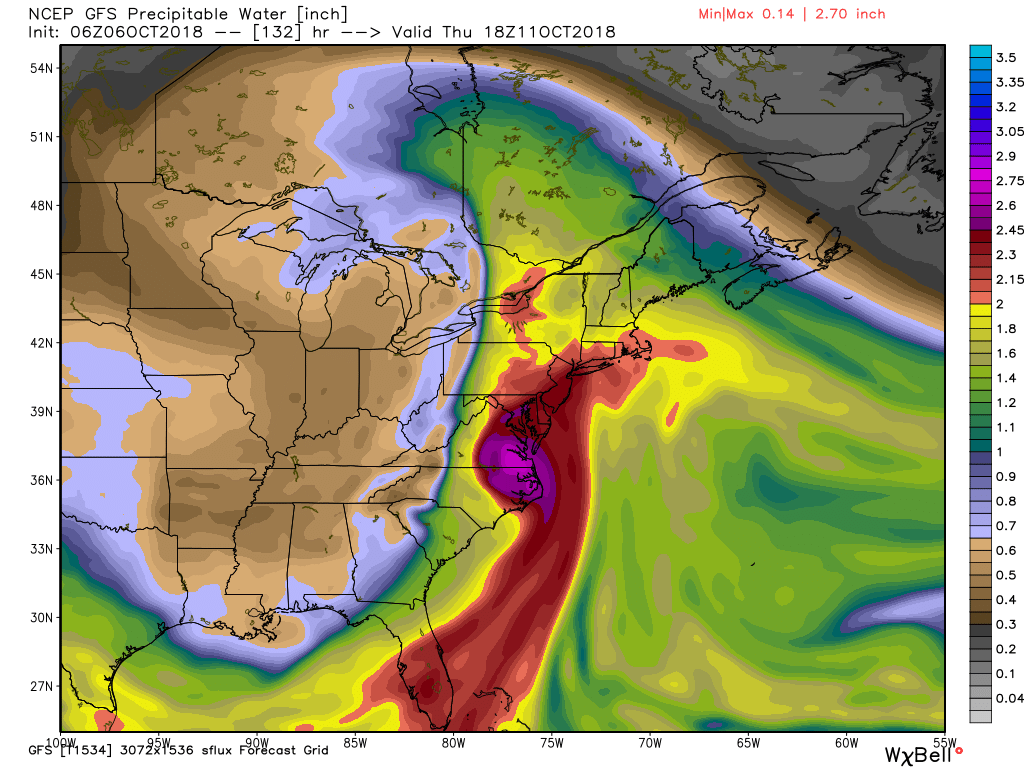
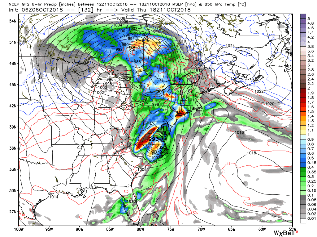
In the medium term, it looks like our area could be impacted with tropical downpours and gusty winds by the end of this upcoming week. Impressive PWAT values, and a deep trop/subtropical moisture connection showing up in all the modeling up and down the east coast as the tropical system interacts with a frontal boundary. Differences in the exact details amongst the models still exist.


_________________
"In weather and in life, there's no winning and losing; there's only winning and learning."
WINTER 2012/2013 TOTALS 43.65"WINTER 2017/2018 TOTALS 62.85" WINTER 2022/2023 TOTALS 4.9"
WINTER 2013/2014 TOTALS 64.85"WINTER 2018/2019 TOTALS 14.25" WINTER 2023/2024 TOTALS 13.1"
WINTER 2014/2015 TOTALS 71.20"WINTER 2019/2020 TOTALS 6.35"
WINTER 2015/2016 TOTALS 35.00"WINTER 2020/2021 TOTALS 37.75"
WINTER 2016/2017 TOTALS 42.25"WINTER 2021/2022 TOTALS 31.65"

sroc4- Admin

- Posts : 8441
Reputation : 302
Join date : 2013-01-07
Location : Wading River, LI
 Re: Long Range Thread 17.0
EURO monthly for winter (DJF). Umm...WOW


_________________
_______________________________________________________________________________________________________
CLICK HERE to view NJ Strong Snowstorm Classifications
 Re: Long Range Thread 17.0
Frank_Wx wrote:EURO monthly for winter (DJF). Umm...WOW
_________________
Mugs
AKA:King: Snow Weenie
Self Proclaimed
WINTER 2014-15 : 55.12" +.02 for 6 coatings (avg. 35")
WINTER 2015-16 Total - 29.8" (Avg 35")
WINTER 2016-17 : 39.5" so far

amugs- Advanced Forecaster - Mod

- Posts : 15130
Reputation : 213
Join date : 2013-01-07
Age : 54
Location : Hillsdale,NJ
 Re: Long Range Thread 17.0
Oct.3rd ENSO weeklies- Nino 1+2:0.7 Nino 3:0.7 Nino 3.4:0.7 Nino 4:0.8

nutleyblizzard- Senior Enthusiast

- Posts : 1963
Reputation : 41
Join date : 2014-01-30
Age : 58
Location : Nutley, new jersey
Page 3 of 41 •  1, 2, 3, 4 ... 22 ... 41
Page 3 of 41
Permissions in this forum:
You cannot reply to topics in this forum|
|
|

 Home
Home


