Long Range Thread 17.0
+40
Radz
lglickman1
Wheezer
aiannone
heehaw453
SENJsnowman
Scullybutcher
jake732
Sanchize06
larryrock72
bobjohnsonforthehall
SnowForest
hyde345
SoulSingMG
weatherwatchermom
MattyICE
GreyBeard
Smittyaj623
HectorO
Vinnydula
Nyi1058
jmanley32
CPcantmeasuresnow
Dunnzoo
algae888
skinsfan1177
Snow88
Quietace
rb924119
dkodgis
sroc4
docstox12
Grselig
amugs
Math23x7
billg315
nutleyblizzard
frank 638
mwilli5783
Frank_Wx
44 posters
Page 21 of 41
Page 21 of 41 •  1 ... 12 ... 20, 21, 22 ... 31 ... 41
 Re: Long Range Thread 17.0
weatherwatchermom wrote:Frank thank you for your analysis this morning! Really hope it comes to fruition!
I have a question for the weekend..if anyone can help me out... I see the it says, heavy rain Friday into Saturday...do you think it will rain all day on Saturday?? Wreaths across America is this Saturday, starting at 11 am...can anyone tell me if they think it will rain all day?? Thank you...(is this the right thread for this question?)
The timing is not clear. The GFS has rain beginning 4am Saturday last into all morning Sunday. The Canadian has rain starting Friday and it tapering off Saturday night.
Either way, Saturday morning into early afternoon looks ugly.
 Re: Long Range Thread 17.0
Frank_Wx wrote:weatherwatchermom wrote:Frank thank you for your analysis this morning! Really hope it comes to fruition!
I have a question for the weekend..if anyone can help me out... I see the it says, heavy rain Friday into Saturday...do you think it will rain all day on Saturday?? Wreaths across America is this Saturday, starting at 11 am...can anyone tell me if they think it will rain all day?? Thank you...(is this the right thread for this question?)
The timing is not clear. The GFS has rain beginning 4am Saturday last into all morning Sunday. The Canadian has rain starting Friday and it tapering off Saturday night.
Either way, Saturday morning into early afternoon looks ugly.
Thanks Frank...I really hope this changes...fingers crossed...It will suck to place wreaths in the pouring rain..
weatherwatchermom- Senior Enthusiast

- Posts : 3733
Join date : 2014-11-25
rb924119- Meteorologist

- Posts : 6889
Reputation : 194
Join date : 2013-02-06
Age : 32
Location : Greentown, Pa
rb924119- Meteorologist

- Posts : 6889
Reputation : 194
Join date : 2013-02-06
Age : 32
Location : Greentown, Pa
 Re: Long Range Thread 17.0
FV3!!!!
rb924119- Meteorologist

- Posts : 6889
Reputation : 194
Join date : 2013-02-06
Age : 32
Location : Greentown, Pa
 Re: Long Range Thread 17.0
rb924119 wrote:FV3!!!!
There are no pictures attached ..are you just teasing us?

weatherwatchermom- Senior Enthusiast

- Posts : 3733
Reputation : 77
Join date : 2014-11-25
Age : 60
Location : Hazlet Township, NJ
 Re: Long Range Thread 17.0
weatherwatchermom wrote:rb924119 wrote:FV3!!!!
There are no pictures attached ..are you just teasing us?
Better pattern near Xmas with a possible storm

Snow88- Senior Enthusiast

- Posts : 2193
Reputation : 4
Join date : 2013-01-09
Age : 35
Location : Brooklyn, NY
 Re: Long Range Thread 17.0
Snow88 wrote:weatherwatchermom wrote:rb924119 wrote:FV3!!!!
There are no pictures attached ..are you just teasing us?
Better pattern near Xmas with a possible storm
Thank you! and fingers crossed!

weatherwatchermom- Senior Enthusiast

- Posts : 3733
Reputation : 77
Join date : 2014-11-25
Age : 60
Location : Hazlet Township, NJ
 Re: Long Range Thread 17.0
rob. You still seeing snow potential for just after this weekends warm up and rain?
Guest- Guest
 Re: Long Range Thread 17.0
Who wants to talk about the Miller B the GFS is showing for Tuesday..... 

SoulSingMG- Senior Enthusiast

- Posts : 2853
Reputation : 74
Join date : 2013-12-11
Location : Long Island City, NY
 Re: Long Range Thread 17.0
SoulSingMG wrote:Who wants to talk about the Miller B the GFS is showing for Tuesday.....
Soul 1 post above yours is mine. I was asking rb that exact question. I think he alluded to this possibility last week. If he did and it’s starting to show up in the models good on him.
Guest- Guest
 Re: Long Range Thread 17.0
i do i do bring on the stormSoulSingMG wrote:Who wants to talk about the Miller B the GFS is showing for Tuesday.....
frank 638- Senior Enthusiast

- Posts : 2824
Reputation : 37
Join date : 2016-01-01
Age : 40
Location : bronx ny
 Re: Long Range Thread 17.0
syosnow94 wrote:rob. You still seeing snow potential for just after this weekends warm up and rain?
Why do you keep adding an “o” to my screen name? Ahaha not that I really mind, as I know who you’re referring to, but it’s kinda funny lmaooooo
Anyway, getting to your more important question, I haven’t had much time to really look too deeply since my previous posts on it last week. I will TRY to get to a more in-depth post tomorrow before I go to work, but I have to get back to my apartment first lol I’m currently home and don’t have the greatest resources here haha if I can’t get to it tomorrow, I will try tomorrow night after work.
rb924119- Meteorologist

- Posts : 6889
Reputation : 194
Join date : 2013-02-06
Age : 32
Location : Greentown, Pa
 Re: Long Range Thread 17.0
A few light snow events showing up on models as well as snow showing up around Christmas wouldn't that be something

skinsfan1177- Senior Enthusiast

- Posts : 4485
Reputation : 35
Join date : 2013-01-07
Age : 46
Location : Point Pleasant Boro
 Re: Long Range Thread 17.0
The stratospheric warming event remains on track - with the GFS predicting zonal winds reversing at 10 hPa shortly after Christmas. The warming event itself will get started almost 1 week BEFORE Christmas. A pattern change to stormier weather (whether that means rain or snow remains to be seen) is likely around Christmas. Maybe even a storm on Christmas....


_________________
_______________________________________________________________________________________________________
CLICK HERE to view NJ Strong Snowstorm Classifications
 Re: Long Range Thread 17.0
On 12/6/2018 at 4:41 PM, rb924119 said:
Ignoring 850's, and again, only at face value, this to me appears to be setting for one of those "sneaky events", where we get lulled to sleep by the looks aloft. Obviously, that first system depicted by the anomalies over and east of the Mid-Atlantic would be warm. The origins of that eastern Canadian ridging are Maritime in nature. BUT, what draws my attention here is what's coming in BEHIND it. Yes, I see the negatives pushing onshore of the West Coast, which would limit the duration of the PNA spike, but in this type of setup, I would argue that that is PRECISELY what you would want. As the system deepens and progresses off the Mid-Atlantic, it will continue to tilt negative, thereby enhancing geopotential height rises downstream. However, as the height field becomes increasingly negatively tilted, you will not only start cooling the warmth spread across Canada via warm advection processes by means of the lower-level snow/cold feedback, but you will also start to draw surface high pressure west-northwestward. In exact coordination and timed progression, the PNA ridge would be collapsing eastward. This becomes important, because it's effects are two-fold:
1. By synchronizing the retrogression of the eastern Canadian ridging with the progression of the western Canadian ridging, this would work to rapidly enhance higher low-level pressures to the northwest across southern and central Canada. Noting the decaying warmth of the Maritime airmass thanks to the aforementioned lower-level feedback, and also now drawing some influence from a truer Continental airmass, the further mixing of these two would allow a marginally cold to measurably below-normal airmass to start becoming established to our north, which would then start being tapped via cold advection on the backside of our departing Mid-Atlantic system as well as through the developing pressure perturbations in response to the larger pattern (building pressure to the north, lowering pressures to the south, covered below).
2. Note the evidence of the shortwave(s) between the PNA and eastern Canadian ridging. As the two ridges are forced to merge, there's only one direction for that shortwave/those shortwaves to go - south and/or southeastward right on the heels of the lead wave and in the developing underbelly of the ridging. Seeing as though this wave/these waves would have origins in higher latitudes, it would provide an initial shot of a fresh Arctic injection to the system likely developing across the central Mississippi Valley at this time, with further enhancement of higher pressures to the north in its/their wake. With the non-traditional (though workable) blocking evolving to the north and northeast, this secondary feature/these secondary features would be forced along a similar trajectory as the first wave, BUT WITH AN AVAILABLE AND FRESHLY DEVELOPING COLD AIR SOURCE. Seeing evidence of an active Sub-tropical jet, as evidenced by the tongue of neutral height anomalies into and off the western coast of Mexico, this would have the potential to end up as another phased system, and with the cold air seemingly available to work with, and the dynamics that this pattern suggests would be in play, if you're looking for a way to end a windswept rain in December with a bang, well, this is certainly one way to draw it up in my opinion.
Again, this is OLY AT FACE VALUE WITH NO OTHER SYNOPTIC, GLOBAL, OR HEMISPHERIC ANALYSIS PERFORMED, SO PLEASE DON'T TAKE THIS TO HEART, but that's the type of evolution that I see here, and the reason why it has a lot of my interest right now for our next potential.
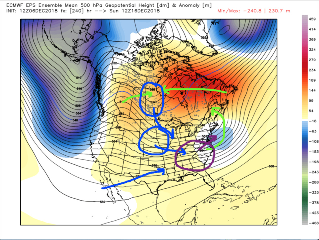
Green: progression of initial Mid-Atlantic wave and ridging
Blue: progression of following wave(s) and Sub-tropical disturbance/jet
Purple: HYPOTHETICAL location of rapidly maturing cyclone
On 12/7/2018 at 3:55 PM, rb924119 said:
I do not have time to elaborate now, but the period from December 16th/17th through the 19th/20th is starting to really acquire my attention for our next possible wintry threat, and I am expecting that we may start to see more wintry runs in coming days. The crux of my argument presented last evening remains, and is present on all ensemble guidance; however, when we account for the stochastic reaction of the atmospheric streamflow in accordance with @Isotherm‘s progged evolution, we should see wavelengths shorten such that it results in a mean maintenance and then proliferation of western NAMER ridging at a key time. I will go into detail in coming days, provided my thinking remains unchanged, and nobody elaborates before I can get back to it haha
I wanted to quote these two posts to serve as a recap for where my thoughts initiated regarding the upcoming period from the 16th/17th through the 19th/20th. Obviously, the modeling has changed somewhat with regard to the overall evolution of this period, but many of the main players are still present. For example, we still have our "bowling ball" low ejecting from the southern states beneath stout North American ridging, we still have a rapidly developing western North American ridge, and we still have the energies from the higher latitudes involved. Some of the differences, though, are that the ridging over eastern North America DOES NOT have origins from the Atlantic/sub-tropics; instead, it has actually raced across from the Pacific, which means that although it isn't "cold", it's certainly cooler than it otherwise would have been had modeling from above verified verbatim. Secondly, the southern stream piece that I mentioned in the quoted posts will not be there; it was phantom in this case.
Now, let's get down to system 1, the "bowling ball". Originally, I had just assumed that this system would be too warm for anything frozen anywhere near our area given the source region of the developing ridge. At this time (quoted post), it was progged to evolve from very strong synoptic warm advection in response to our "bowling ball" mid-level low, which would have provided western Atlantic and even some Sub-tropical air out ahead of it. Even with it being drawn northward into significantly colder regions, it was not going to have enough time to cool to levels where it would have been possible for any of us to see frozen precipitation. However, this evolution has changed. The ridging that develops across eastern North America actually races across the southern tier of Canada thanks to the reshuffling of the Northern Hemispheric pattern (part and parcel of global, tropical, and Stratospheric forcing mechanisms discussed ad-nauseum). So, even though it is still Pacific-born, it will be substantially colder than what we would have had to work with otherwise, especially since it will have time to cool a bit thanks to the anomalous snow cover in Canada (oh yes, that's still a factor). Although the pattern is still generally progressive in nature, we have some net gains to make, at least in my opinion, when it comes to the possibility of seeing anything frozen. First of all, with that ridge sliding eastward through the southern tier of Canada, it allows a sneaky and mildly strong surface high to be located in an almost ideal spot when viewed in the context of big winter storms; right in southeastern Canada as the precipitation starts, then slowly drifts eastward with the system as it departs. This helps to mitigate the warm surge through the lower-levels via cold air advection/drainage (ageostrophic flow). Again, even though it isn't a classic "cold" high with high-latitude origins, I think it will be cold enough toward the end of the system as the Canadian cold/snow feedback should start to really have an impact, when combined with some moderate dynamics. Secondly, even though the MJO will be solidly into Phase 4, not only will it be losing its coherent structure, but it will also be countered by a recent and significant Niño 1.2 drop. The wildcard here *could* be that the Niño 1.2 drop actually has a larger overall impact on the pattern than the increasingly incoherent MJO pulse, which is why I can actually see suppression becoming an issue again (remember, temperature changes in this region tend to correlate well with changes of the same sign in the eastern U.S. approximately 2-3 weeks later, and this decline began ~November 26th and persisted through ~December 5th, which matches our timeline well.). Colder signal means that the trough would therefore be located further south and the cold air is allowed to press further.
In looking at the Northern Hemisphere we have the following: +E.P.O./W.P.O./A.O. countered (according to my subjective analysis) by: -N.A.O./pseudo-50N/50E low (will revisit this shortly)/+P.N.A. (will revisit this too). However, we also have a great 70N/70E ridge AND a much more favorable SST anomaly configuration surrounding the C.O.N.U.S. with an essentially neutral Gulf, and very cold coastal New England shelf (should aid in mitigating some oceanic warm advection and bolster mid-level trough strength thanks to lower-level heat flux/lack thereof) juxtaposed nicely with a very warm East Pacific. Note that the S.O.I. was again ignored here, as there is still no coherent signal. So, basis this, we have more synoptic forcing mechanisms favoring a colder, further south evolution with our first feature. Now, I said that I wanted to revisit the pseudo-50N/50E low. Why? I call it a "pseudo-"low because it isn't exactly where its name suggests that it should be if you look at the modeling - it's sliding east too quickly such that it's closer to ~55N/45W by the time our system really gets close. However, just like with the +P.N.A., I am (subjectively) accounting for further corrections. The correction that I am counting on in order to have these truly in place are due to the reasons mentioned in my second quoted post above. The wavelengths across the Northern Hemisphere are shortening, rapidly, in response to the extreme perturbations that are ongoing, and will continue to be. As a result of this, even though the overall pattern is still generally progressive, over coming model runs I expect us to see the features "retract". Now, this will not actually be the the physical features themselves retracting; rather, it will be the modeling playing catch-up to just how short and sharp these wavelengths will actually be come game time. As a result, the pseudo-50N/50W low and rapidly developing P.N.A. ridge should have a bit more staying power, and therefore allow the mid-level stream flow and cold air to push more than expected. As I mentioned earlier, though, while I think an overall southern track/colder solution is likely, we may see a situation where you have the cold air and no precipitation, or precipitation and not enough cold air. However, at this time, I'm willing to take my chances and say that I think thermals will be cold enough to support snow and ice to about I-95 and I-80 with the first system, mainly during and after the energy transfers to the coast, with light (perhaps moderate) accumulations of snow and/or ice.
All of the above also sets up the second system, visually outlined in the first post, although we will be missing the southern stream component. That aside, though, it will be nearly the exact same set of circumstances in play, but since we will now have true high-latitude energies involved, we will have a fresh injection of true cold air to work with. Assuming the hypothesized corrections from the retraction maintain the +P.N.A. long enough (hang the ridge axis a bit further back), we will be gaining a neutralizing A.O. regime, while losing the pseudo-50N/50W low, so by my analysis, we will still have an overall regime that favors that northern energy to dig further and be stronger than currently modeled. Accounting for my assumed corrections, I expect to see this occur further west; somewhere approximately over Minnesota instead of Lake Superior. This should put much of our area in the game for a second round of accumulating snowfall, though eastern regions would be climatologically favored in this situation, given that it would be most like a Miller-B storm type.
I really hope that this post makes sense, but if not, please let me know!! I hope that you all enjoyed it, and if anybody wants to follow up, I will try to do my best once I wake up this afternoon haha sorry I don't have any annotated images, but I had limited time today, and certainly not enough time for a video, so I do apologize for the length of this discussion.
Ignoring 850's, and again, only at face value, this to me appears to be setting for one of those "sneaky events", where we get lulled to sleep by the looks aloft. Obviously, that first system depicted by the anomalies over and east of the Mid-Atlantic would be warm. The origins of that eastern Canadian ridging are Maritime in nature. BUT, what draws my attention here is what's coming in BEHIND it. Yes, I see the negatives pushing onshore of the West Coast, which would limit the duration of the PNA spike, but in this type of setup, I would argue that that is PRECISELY what you would want. As the system deepens and progresses off the Mid-Atlantic, it will continue to tilt negative, thereby enhancing geopotential height rises downstream. However, as the height field becomes increasingly negatively tilted, you will not only start cooling the warmth spread across Canada via warm advection processes by means of the lower-level snow/cold feedback, but you will also start to draw surface high pressure west-northwestward. In exact coordination and timed progression, the PNA ridge would be collapsing eastward. This becomes important, because it's effects are two-fold:
1. By synchronizing the retrogression of the eastern Canadian ridging with the progression of the western Canadian ridging, this would work to rapidly enhance higher low-level pressures to the northwest across southern and central Canada. Noting the decaying warmth of the Maritime airmass thanks to the aforementioned lower-level feedback, and also now drawing some influence from a truer Continental airmass, the further mixing of these two would allow a marginally cold to measurably below-normal airmass to start becoming established to our north, which would then start being tapped via cold advection on the backside of our departing Mid-Atlantic system as well as through the developing pressure perturbations in response to the larger pattern (building pressure to the north, lowering pressures to the south, covered below).
2. Note the evidence of the shortwave(s) between the PNA and eastern Canadian ridging. As the two ridges are forced to merge, there's only one direction for that shortwave/those shortwaves to go - south and/or southeastward right on the heels of the lead wave and in the developing underbelly of the ridging. Seeing as though this wave/these waves would have origins in higher latitudes, it would provide an initial shot of a fresh Arctic injection to the system likely developing across the central Mississippi Valley at this time, with further enhancement of higher pressures to the north in its/their wake. With the non-traditional (though workable) blocking evolving to the north and northeast, this secondary feature/these secondary features would be forced along a similar trajectory as the first wave, BUT WITH AN AVAILABLE AND FRESHLY DEVELOPING COLD AIR SOURCE. Seeing evidence of an active Sub-tropical jet, as evidenced by the tongue of neutral height anomalies into and off the western coast of Mexico, this would have the potential to end up as another phased system, and with the cold air seemingly available to work with, and the dynamics that this pattern suggests would be in play, if you're looking for a way to end a windswept rain in December with a bang, well, this is certainly one way to draw it up in my opinion.
Again, this is OLY AT FACE VALUE WITH NO OTHER SYNOPTIC, GLOBAL, OR HEMISPHERIC ANALYSIS PERFORMED, SO PLEASE DON'T TAKE THIS TO HEART, but that's the type of evolution that I see here, and the reason why it has a lot of my interest right now for our next potential.

Green: progression of initial Mid-Atlantic wave and ridging
Blue: progression of following wave(s) and Sub-tropical disturbance/jet
Purple: HYPOTHETICAL location of rapidly maturing cyclone
On 12/7/2018 at 3:55 PM, rb924119 said:
I do not have time to elaborate now, but the period from December 16th/17th through the 19th/20th is starting to really acquire my attention for our next possible wintry threat, and I am expecting that we may start to see more wintry runs in coming days. The crux of my argument presented last evening remains, and is present on all ensemble guidance; however, when we account for the stochastic reaction of the atmospheric streamflow in accordance with @Isotherm‘s progged evolution, we should see wavelengths shorten such that it results in a mean maintenance and then proliferation of western NAMER ridging at a key time. I will go into detail in coming days, provided my thinking remains unchanged, and nobody elaborates before I can get back to it haha
I wanted to quote these two posts to serve as a recap for where my thoughts initiated regarding the upcoming period from the 16th/17th through the 19th/20th. Obviously, the modeling has changed somewhat with regard to the overall evolution of this period, but many of the main players are still present. For example, we still have our "bowling ball" low ejecting from the southern states beneath stout North American ridging, we still have a rapidly developing western North American ridge, and we still have the energies from the higher latitudes involved. Some of the differences, though, are that the ridging over eastern North America DOES NOT have origins from the Atlantic/sub-tropics; instead, it has actually raced across from the Pacific, which means that although it isn't "cold", it's certainly cooler than it otherwise would have been had modeling from above verified verbatim. Secondly, the southern stream piece that I mentioned in the quoted posts will not be there; it was phantom in this case.
Now, let's get down to system 1, the "bowling ball". Originally, I had just assumed that this system would be too warm for anything frozen anywhere near our area given the source region of the developing ridge. At this time (quoted post), it was progged to evolve from very strong synoptic warm advection in response to our "bowling ball" mid-level low, which would have provided western Atlantic and even some Sub-tropical air out ahead of it. Even with it being drawn northward into significantly colder regions, it was not going to have enough time to cool to levels where it would have been possible for any of us to see frozen precipitation. However, this evolution has changed. The ridging that develops across eastern North America actually races across the southern tier of Canada thanks to the reshuffling of the Northern Hemispheric pattern (part and parcel of global, tropical, and Stratospheric forcing mechanisms discussed ad-nauseum). So, even though it is still Pacific-born, it will be substantially colder than what we would have had to work with otherwise, especially since it will have time to cool a bit thanks to the anomalous snow cover in Canada (oh yes, that's still a factor). Although the pattern is still generally progressive in nature, we have some net gains to make, at least in my opinion, when it comes to the possibility of seeing anything frozen. First of all, with that ridge sliding eastward through the southern tier of Canada, it allows a sneaky and mildly strong surface high to be located in an almost ideal spot when viewed in the context of big winter storms; right in southeastern Canada as the precipitation starts, then slowly drifts eastward with the system as it departs. This helps to mitigate the warm surge through the lower-levels via cold air advection/drainage (ageostrophic flow). Again, even though it isn't a classic "cold" high with high-latitude origins, I think it will be cold enough toward the end of the system as the Canadian cold/snow feedback should start to really have an impact, when combined with some moderate dynamics. Secondly, even though the MJO will be solidly into Phase 4, not only will it be losing its coherent structure, but it will also be countered by a recent and significant Niño 1.2 drop. The wildcard here *could* be that the Niño 1.2 drop actually has a larger overall impact on the pattern than the increasingly incoherent MJO pulse, which is why I can actually see suppression becoming an issue again (remember, temperature changes in this region tend to correlate well with changes of the same sign in the eastern U.S. approximately 2-3 weeks later, and this decline began ~November 26th and persisted through ~December 5th, which matches our timeline well.). Colder signal means that the trough would therefore be located further south and the cold air is allowed to press further.
In looking at the Northern Hemisphere we have the following: +E.P.O./W.P.O./A.O. countered (according to my subjective analysis) by: -N.A.O./pseudo-50N/50E low (will revisit this shortly)/+P.N.A. (will revisit this too). However, we also have a great 70N/70E ridge AND a much more favorable SST anomaly configuration surrounding the C.O.N.U.S. with an essentially neutral Gulf, and very cold coastal New England shelf (should aid in mitigating some oceanic warm advection and bolster mid-level trough strength thanks to lower-level heat flux/lack thereof) juxtaposed nicely with a very warm East Pacific. Note that the S.O.I. was again ignored here, as there is still no coherent signal. So, basis this, we have more synoptic forcing mechanisms favoring a colder, further south evolution with our first feature. Now, I said that I wanted to revisit the pseudo-50N/50E low. Why? I call it a "pseudo-"low because it isn't exactly where its name suggests that it should be if you look at the modeling - it's sliding east too quickly such that it's closer to ~55N/45W by the time our system really gets close. However, just like with the +P.N.A., I am (subjectively) accounting for further corrections. The correction that I am counting on in order to have these truly in place are due to the reasons mentioned in my second quoted post above. The wavelengths across the Northern Hemisphere are shortening, rapidly, in response to the extreme perturbations that are ongoing, and will continue to be. As a result of this, even though the overall pattern is still generally progressive, over coming model runs I expect us to see the features "retract". Now, this will not actually be the the physical features themselves retracting; rather, it will be the modeling playing catch-up to just how short and sharp these wavelengths will actually be come game time. As a result, the pseudo-50N/50W low and rapidly developing P.N.A. ridge should have a bit more staying power, and therefore allow the mid-level stream flow and cold air to push more than expected. As I mentioned earlier, though, while I think an overall southern track/colder solution is likely, we may see a situation where you have the cold air and no precipitation, or precipitation and not enough cold air. However, at this time, I'm willing to take my chances and say that I think thermals will be cold enough to support snow and ice to about I-95 and I-80 with the first system, mainly during and after the energy transfers to the coast, with light (perhaps moderate) accumulations of snow and/or ice.
All of the above also sets up the second system, visually outlined in the first post, although we will be missing the southern stream component. That aside, though, it will be nearly the exact same set of circumstances in play, but since we will now have true high-latitude energies involved, we will have a fresh injection of true cold air to work with. Assuming the hypothesized corrections from the retraction maintain the +P.N.A. long enough (hang the ridge axis a bit further back), we will be gaining a neutralizing A.O. regime, while losing the pseudo-50N/50W low, so by my analysis, we will still have an overall regime that favors that northern energy to dig further and be stronger than currently modeled. Accounting for my assumed corrections, I expect to see this occur further west; somewhere approximately over Minnesota instead of Lake Superior. This should put much of our area in the game for a second round of accumulating snowfall, though eastern regions would be climatologically favored in this situation, given that it would be most like a Miller-B storm type.
I really hope that this post makes sense, but if not, please let me know!! I hope that you all enjoyed it, and if anybody wants to follow up, I will try to do my best once I wake up this afternoon haha sorry I don't have any annotated images, but I had limited time today, and certainly not enough time for a video, so I do apologize for the length of this discussion.
rb924119- Meteorologist

- Posts : 6889
Reputation : 194
Join date : 2013-02-06
Age : 32
Location : Greentown, Pa
 Re: Long Range Thread 17.0
That was a GREAT right up Ray, and very easy to read- at least for me. Thank you! I'm south and east,so I'll be looking more for the second scenario.
The thrill is in the hunt.
The thrill is in the hunt.
SENJsnowman- Senior Enthusiast

- Posts : 1186
Reputation : 61
Join date : 2017-01-06
Age : 51
Location : Bayville, NJ
 Re: Long Range Thread 17.0
Ray fantastic write up as usual, but as we did yesterday I will cont to respectfully disagree somewhat and now play devil's advocate to your argument. For now I am going to stay away from the second system for middle of next week and focus on the Sunday to Monday threat. My argument on 33 from yesterday still rings true for me: Here is my post with some slight modification to the wording because I can see what your saying regarding that ridging that slides across the southeastern third of Canada.
The dynamics of this storm wont/shouldnt generate enough cold air in time. Again my argument is that if you get heavy enough precip into any given area it brings the "too warm" to do anything because under that precip the DP will be too high. The temp can only drop to a point between the two (I know you know that). This system is a cutoff low that comes out of the deep south that heads into an air mass that is tepid at best. There is no connection to any cold air anywhere on its way. So again if the upper level vorticity where to position itself further west to bring the precip shield in all it does it brings warm air with it since there is simply no cold air to be had.
So here is where I conceded to your argument some. Like yousaid we essentially have a "bowling ball" moving into the area, BUT it is a cutoff low that originates from the deep south. It is "cutoff from the mean flow to the north. The air mass in place over our region as the bowling ball approaches is very warm from the surface trhough 850's.
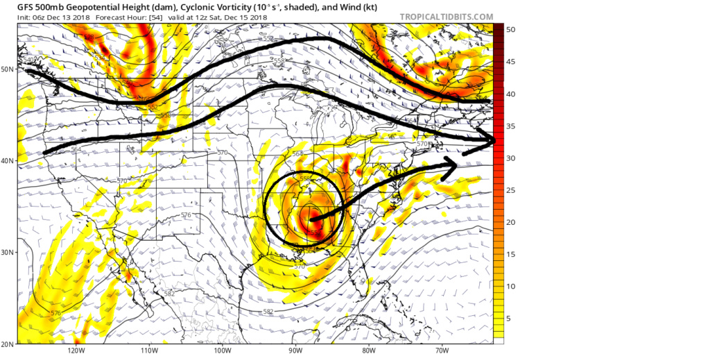
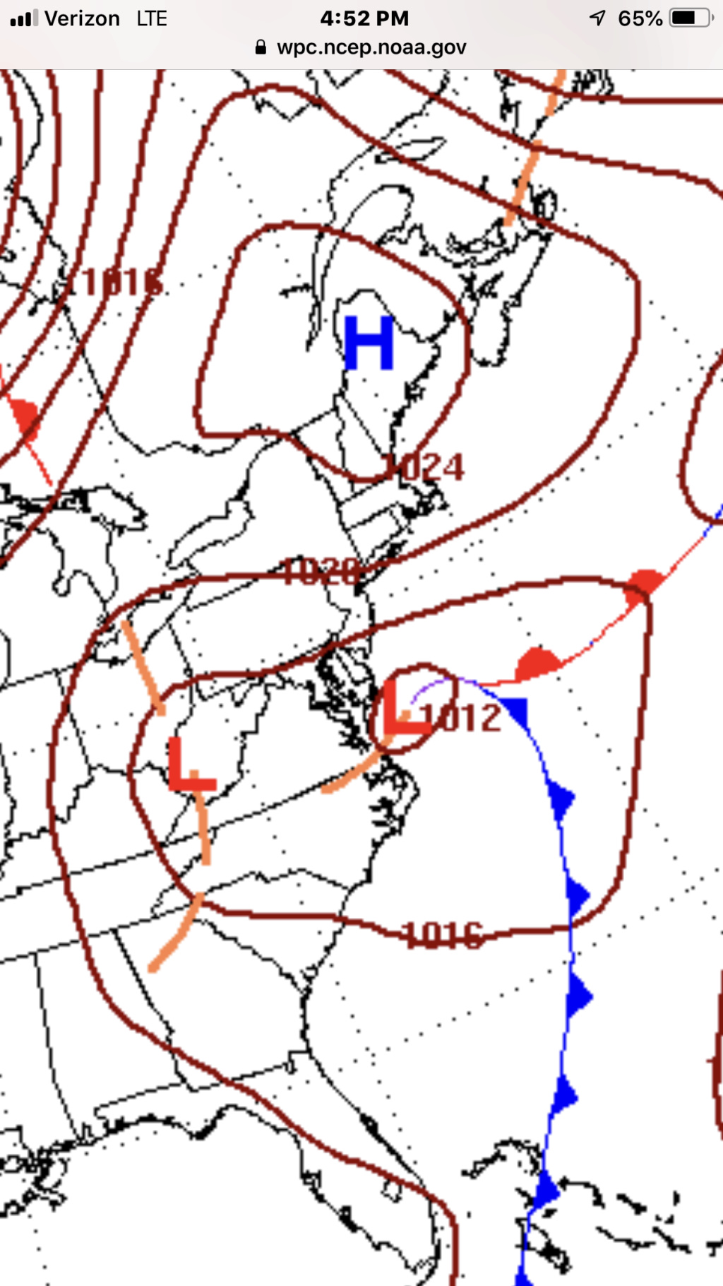
Normally when I see a cutoff low pass to the south of us in the position shown in the image below and the trough axis tilting negative in the winter time I jusmp for joy at the opportunities presenting themselves.

But here is the problem. Again on approach the deep 500mb low creates physical parameters such that the source regions of the air into our region is incredibly warm.
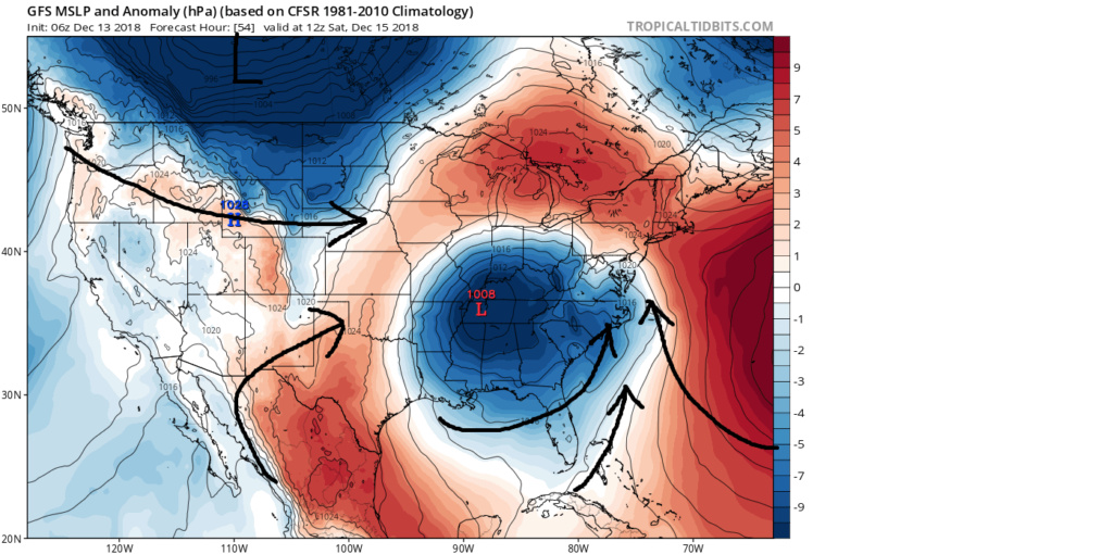
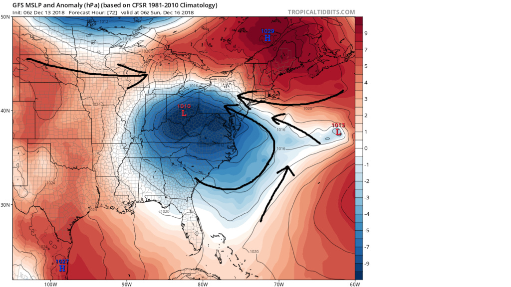


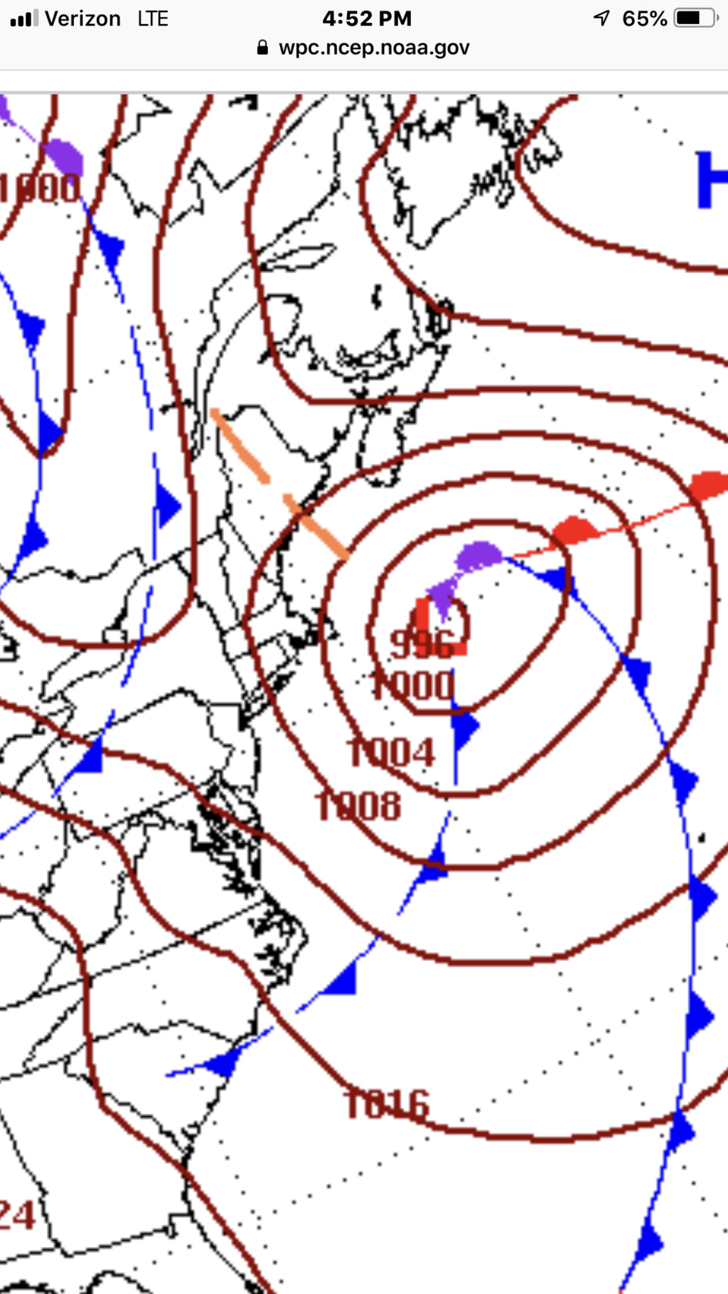
Now after the primary surface low transfers off the coast you begin to see that there is some cold air filtering in from the north. The source region from which the HP to the north originates from is that from the Pac and not from the colder northern regions over N NE and SE Canada. There is only a limited cold air source region from which it can draw from as there are still warm source regions at play here as well.

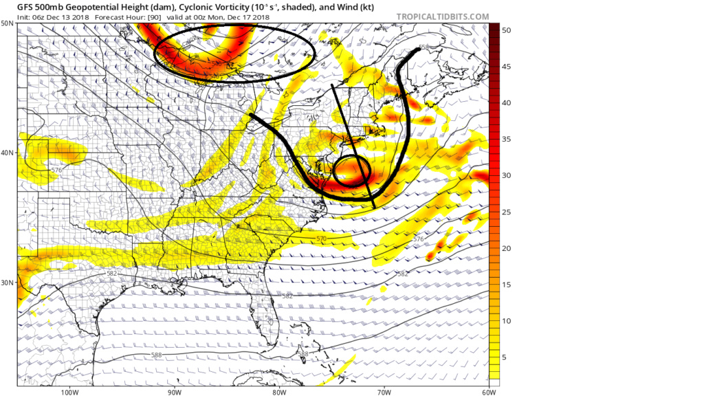
Take notice at the 500mb image above hr 90 at the northern stream energy diving in from S central Canada into the W GL. The pattern overall is still a progressive one. This N energy will act to kick the cutoff further east as it dives into the NE. The problem with the system for late Sunday into Monday is does it have enough time to overcome the warmth that preceded it before kicking to far east to make a difference. My argument is that if the initial LP placement, after the transfer off the coast, is in a little tighter to the coast allowing more of the heavier precip to make it to the N&W locations it brings with it even warmer air such that there will be less ability for dynamic cooling to make enough of a difference. Currently I don't believe there is enough time for the colder air your referring to Ray to dilute out an overwhelmingly warm precursor set up to make much of a difference. I will absolutely acknowledge however that cold air is often under modeled in its ability to influence the set up, and there is just enough time left to lead me to pause a little to say tha areas N&W of the I 95 should still keep an eye on conditions.
The dynamics of this storm wont/shouldnt generate enough cold air in time. Again my argument is that if you get heavy enough precip into any given area it brings the "too warm" to do anything because under that precip the DP will be too high. The temp can only drop to a point between the two (I know you know that). This system is a cutoff low that comes out of the deep south that heads into an air mass that is tepid at best. There is no connection to any cold air anywhere on its way. So again if the upper level vorticity where to position itself further west to bring the precip shield in all it does it brings warm air with it since there is simply no cold air to be had.
So here is where I conceded to your argument some. Like yousaid we essentially have a "bowling ball" moving into the area, BUT it is a cutoff low that originates from the deep south. It is "cutoff from the mean flow to the north. The air mass in place over our region as the bowling ball approaches is very warm from the surface trhough 850's.

Normally when I see a cutoff low pass to the south of us in the position shown in the image below and the trough axis tilting negative in the winter time I jusmp for joy at the opportunities presenting themselves.

But here is the problem. Again on approach the deep 500mb low creates physical parameters such that the source regions of the air into our region is incredibly warm.


Now after the primary surface low transfers off the coast you begin to see that there is some cold air filtering in from the north. The source region from which the HP to the north originates from is that from the Pac and not from the colder northern regions over N NE and SE Canada. There is only a limited cold air source region from which it can draw from as there are still warm source regions at play here as well.


Take notice at the 500mb image above hr 90 at the northern stream energy diving in from S central Canada into the W GL. The pattern overall is still a progressive one. This N energy will act to kick the cutoff further east as it dives into the NE. The problem with the system for late Sunday into Monday is does it have enough time to overcome the warmth that preceded it before kicking to far east to make a difference. My argument is that if the initial LP placement, after the transfer off the coast, is in a little tighter to the coast allowing more of the heavier precip to make it to the N&W locations it brings with it even warmer air such that there will be less ability for dynamic cooling to make enough of a difference. Currently I don't believe there is enough time for the colder air your referring to Ray to dilute out an overwhelmingly warm precursor set up to make much of a difference. I will absolutely acknowledge however that cold air is often under modeled in its ability to influence the set up, and there is just enough time left to lead me to pause a little to say tha areas N&W of the I 95 should still keep an eye on conditions.
_________________
"In weather and in life, there's no winning and losing; there's only winning and learning."
WINTER 2012/2013 TOTALS 43.65"WINTER 2017/2018 TOTALS 62.85" WINTER 2022/2023 TOTALS 4.9"
WINTER 2013/2014 TOTALS 64.85"WINTER 2018/2019 TOTALS 14.25" WINTER 2023/2024 TOTALS 13.1"
WINTER 2014/2015 TOTALS 71.20"WINTER 2019/2020 TOTALS 6.35"
WINTER 2015/2016 TOTALS 35.00"WINTER 2020/2021 TOTALS 37.75"
WINTER 2016/2017 TOTALS 42.25"WINTER 2021/2022 TOTALS 31.65"

sroc4- Admin

- Posts : 8331
Reputation : 301
Join date : 2013-01-07
Location : Wading River, LI
 Re: Long Range Thread 17.0
I will also point out I lost the argument against the cold with the November snow.
_________________
"In weather and in life, there's no winning and losing; there's only winning and learning."
WINTER 2012/2013 TOTALS 43.65"WINTER 2017/2018 TOTALS 62.85" WINTER 2022/2023 TOTALS 4.9"
WINTER 2013/2014 TOTALS 64.85"WINTER 2018/2019 TOTALS 14.25" WINTER 2023/2024 TOTALS 13.1"
WINTER 2014/2015 TOTALS 71.20"WINTER 2019/2020 TOTALS 6.35"
WINTER 2015/2016 TOTALS 35.00"WINTER 2020/2021 TOTALS 37.75"
WINTER 2016/2017 TOTALS 42.25"WINTER 2021/2022 TOTALS 31.65"

sroc4- Admin

- Posts : 8331
Reputation : 301
Join date : 2013-01-07
Location : Wading River, LI
 Re: Long Range Thread 17.0
So, it seems to me that some of our differences regarding the degree of warmth stems from our respective analyses of the eventual track of the system itself. You seem to be hedging on a risk of it tracking further north and west, and therefore be warmer overall than currently progged, while I am hedging on a similar/slightly further south track with a colder overall solution. Obviously, each our stances on that are equally as valid and substantiated, and whilenwe can debate our reasons, neither one of us is going to change the other’s mind aha
That said, you certainly have a point that our system is born of lower/milder latitudes with a marginal airmass preceding its advancement. I can also see where the food comes too late as the system pulls away (acknowledged this risk in my discussion, although I do not personally favor it at this time). However, take a closer look at your middle-two pressure anomaly graphics. At the surface, due to friction, the actual wind direction has a cross-isobaric component to it, but due to the relatively large temperature/density difference between the airmass of the high and the low, that component becomes further enhanced (ageostrophic). As a result, the sensible flow would be much more perpendicular to the isobaric contours such that the cold would be filtering in from the north and northeast throughout the period in question; NOT from the east-southeast. Therefore, the source region would be southeastern Canada and New England, and although marginal, should be enough to overcome the relative warmth during the second half/last third of the event.
Taking the above into consideration, if the low did track further west, the presence of colder air in an overlapping region of better dynamics (enhanced frontogenesis, PVA, etc.) should again be enough to allow a change-over to frozen precip, especially for higher terrain, before the system moves out. I do agree, however, that the pattern is progressive overall, and again, do see the risk of the precip moving out before cold air can come in.
rb924119- Meteorologist

- Posts : 6889
Reputation : 194
Join date : 2013-02-06
Age : 32
Location : Greentown, Pa
 Re: Long Range Thread 17.0
Rb did you get a peek at the 18 z nam

algae888- Advanced Forecaster

- Posts : 5311
Reputation : 46
Join date : 2013-02-05
Age : 61
Location : mt. vernon, new york
 Re: Long Range Thread 17.0
algae888 wrote:Rb did you get a peek at the 18 z nam
That is quite interesting
_________________
"In weather and in life, there's no winning and losing; there's only winning and learning."
WINTER 2012/2013 TOTALS 43.65"WINTER 2017/2018 TOTALS 62.85" WINTER 2022/2023 TOTALS 4.9"
WINTER 2013/2014 TOTALS 64.85"WINTER 2018/2019 TOTALS 14.25" WINTER 2023/2024 TOTALS 13.1"
WINTER 2014/2015 TOTALS 71.20"WINTER 2019/2020 TOTALS 6.35"
WINTER 2015/2016 TOTALS 35.00"WINTER 2020/2021 TOTALS 37.75"
WINTER 2016/2017 TOTALS 42.25"WINTER 2021/2022 TOTALS 31.65"

sroc4- Admin

- Posts : 8331
Reputation : 301
Join date : 2013-01-07
Location : Wading River, LI
 Re: Long Range Thread 17.0
sroc4 wrote:algae888 wrote:Rb did you get a peek at the 18 z nam
That is quite interesting
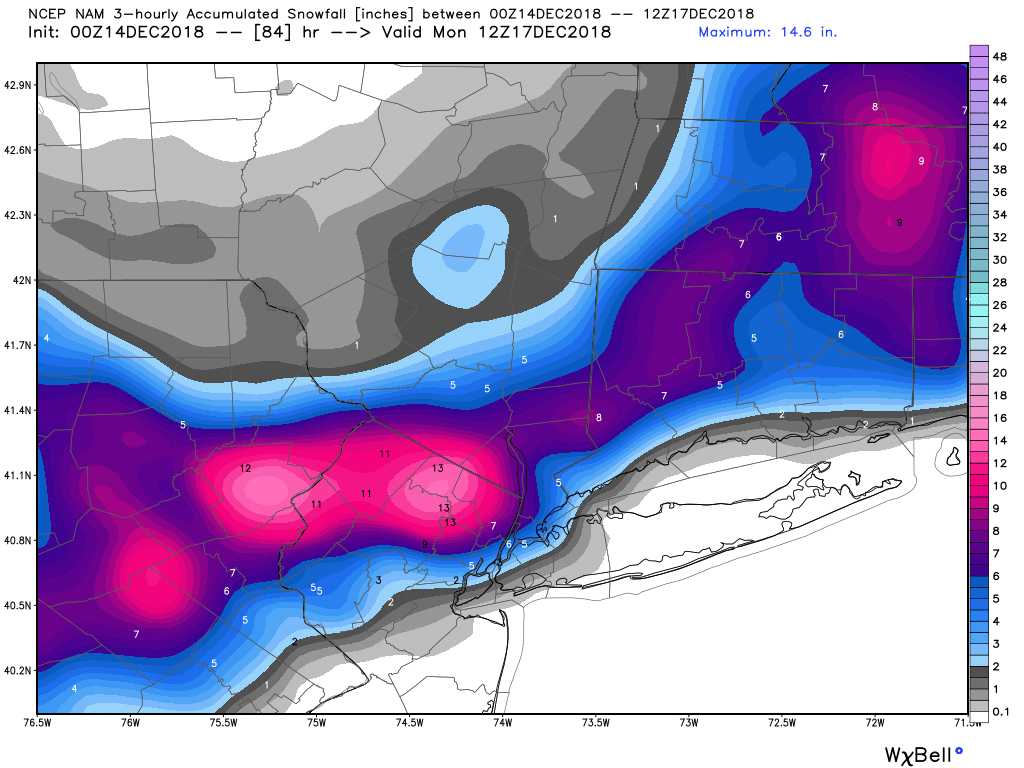
yep, pulling in some cold air at the end... everyone else is warm
_________________
Janet
Snowfall winter of 2023-2024 17.5"
Snowfall winter of 2022-2023 6.0"
Snowfall winter of 2021-2022 17.6" 1" sleet 2/25/22
Snowfall winter of 2020-2021 51.1"
Snowfall winter of 2019-2020 8.5"
Snowfall winter of 2018-2019 25.1"
Snowfall winter of 2017-2018 51.9"
Snowfall winter of 2016-2017 45.6"
Snowfall winter of 2015-2016 29.5"
Snowfall winter of 2014-2015 50.55"
Snowfall winter of 2013-2014 66.5"
Dunnzoo- Senior Enthusiast - Mod

- Posts : 4884
Reputation : 68
Join date : 2013-01-11
Age : 62
Location : Westwood, NJ

jmanley32- Senior Enthusiast

- Posts : 20512
Reputation : 108
Join date : 2013-12-12
Age : 42
Location : Yonkers, NY
 Re: Long Range Thread 17.0
I have to admit I am not liking where we are going in the long range. if you take a look at the ensembles the ridge over Alaska shifts West towards the aleutians cold air is then dumped into the southwest and a ridge forms in the east past 10 days. That's a very nina like pattern. Considering the SOI is positive and has been positive for a while I think it's going to take some time to get into El Nino climate with The Ridge out west trough in the East and Aleutian low. It doesn't mean we can't get us any snow in the next few weeks but it's going to have to be perfect timing. If you think about it Nino climate is usually backloaded So This Is Not Unusual and most Winter forecast that I've read had the best month to be February I just can't stand the wait but it looks like we may have to thank God for that snow storm in november or we would be very frustrated right now.

algae888- Advanced Forecaster

- Posts : 5311
Reputation : 46
Join date : 2013-02-05
Age : 61
Location : mt. vernon, new york
 Re: Long Range Thread 17.0
algae888 wrote:I have to admit I am not liking where we are going in the long range. if you take a look at the ensembles the ridge over Alaska shifts West towards the aleutians cold air is then dumped into the southwest and a ridge forms in the east past 10 days. That's a very nina like pattern. Considering the SOI is positive and has been positive for a while I think it's going to take some time to get into El Nino climate with The Ridge out west trough in the East and Aleutian low. It doesn't mean we can't get us any snow in the next few weeks but it's going to have to be perfect timing. If you think about it Nino climate is usually backloaded So This Is Not Unusual and most Winter forecast that I've read had the best month to be February I just can't stand the wait but it looks like we may have to thank God for that snow storm in november or we would be very frustrated right now.
Backloaded is fine with me but it would be nice to get some snow on the ground for Christmas.Accuweather jibes with what you post here Al, a Pacific type air situation on the CONUS coming up.Even though it was dry so far, at least the cold kept the Holiday Spirit going strong.Let's hope all this changes soon so we get some snow production area wide.

docstox12- Wx Statistician Guru

- Posts : 8502
Reputation : 222
Join date : 2013-01-07
Age : 73
Location : Monroe NY
Page 21 of 41 •  1 ... 12 ... 20, 21, 22 ... 31 ... 41
Page 21 of 41
Permissions in this forum:
You cannot reply to topics in this forum|
|
|

 Home
Home