
 Search
First Wintry Event - 11/15 to 11/16
Page 8 of 17 •  1 ... 5 ... 7, 8, 9 ... 12 ... 17
 ![]()
Re: First Wintry Event - 11/15 to 11/16
![]() by sroc4 Thu Nov 15, 2018 11:58 am
by sroc4 Thu Nov 15, 2018 11:58 am
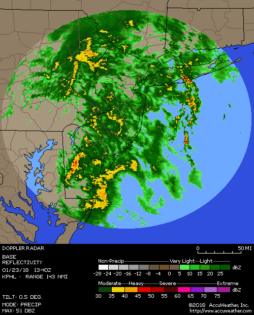
One important thing to keep in mind is even though areas to the sounth have seemd to over achieve, the HP positioning was parked over the Vt region. However, it appears that it is begining its transition off the Ma coastline as we speak. If you look at the sounding below you will see in the bottom R corner the winds have already shifted at the surface to almost due east, maybe ENE, and at 800-1000mb out of the south. Now the site I look at to see actual observations still have winds a little more ENE to NE, but this likely wont last for much longer. The precip has not made it in yet. Again once that HP moves off the coast the conditions along coastal plain will rapidly transition warmer because SST are still 55-65*. Again while early reports to the south are encouraging when the precip makes up to NYC lat we will have to monitor conditions. Again dew points are still in good position to drop temps under heavier banding, but it has to happen soon.


Last edited by sroc4 on Thu Nov 15, 2018 12:00 pm; edited 3 times in total
sroc4- Admin

- Posts : 8331
Join date : 2013-01-07
Re: First Wintry Event - 11/15 to 11/16
![]() by weatherwatchermom Thu Nov 15, 2018 11:59 am
by weatherwatchermom Thu Nov 15, 2018 11:59 am
Scott here it feels and smells like snow I saw a flake or two flying..but that's it currently 34* dp25 feels like 29* out....sroc4 wrote:Anyone resporting from southern jersey??

Last edited by weatherwatchermom on Thu Nov 15, 2018 12:01 pm; edited 1 time in total
weatherwatchermom- Senior Enthusiast

- Posts : 3734
Join date : 2014-11-25


SoulSingMG- Senior Enthusiast
- Posts : 2853
Reputation : 74
Join date : 2013-12-11
Location : Long Island City, NY
Re: First Wintry Event - 11/15 to 11/16
![]() by bobjohnsonforthehall Thu Nov 15, 2018 12:01 pm
by bobjohnsonforthehall Thu Nov 15, 2018 12:01 pm

bobjohnsonforthehall- Posts : 311
Reputation : 19
Join date : 2016-10-02
Location : Flemington NJ
Re: First Wintry Event - 11/15 to 11/16
![]() by SoulSingMG Thu Nov 15, 2018 12:06 pm
by SoulSingMG Thu Nov 15, 2018 12:06 pm

SoulSingMG- Senior Enthusiast
- Posts : 2853
Reputation : 74
Join date : 2013-12-11
Location : Long Island City, NY
Re: First Wintry Event - 11/15 to 11/16
![]() by amugs Thu Nov 15, 2018 12:08 pm
by amugs Thu Nov 15, 2018 12:08 pm
.
Craig:
Getting a little concerned / nervous. I sure wish I had a chance to get acclimated with a few snow showers rather than hitting me up with an all out storm for the first one. Sheesh.
Last edited by amugs on Thu Nov 15, 2018 12:09 pm; edited 1 time in total
_________________
Mugs
AKA:King: Snow Weenie
Self Proclaimed
WINTER 2014-15 : 55.12" +.02 for 6 coatings (avg. 35")
WINTER 2015-16 Total - 29.8" (Avg 35")
WINTER 2016-17 : 39.5" so far

amugs- Advanced Forecaster - Mod

- Posts : 15093
Reputation : 213
Join date : 2013-01-07
Age : 54
Location : Hillsdale,NJ
Re: First Wintry Event - 11/15 to 11/16
![]() by algae888 Thu Nov 15, 2018 12:08 pm
by algae888 Thu Nov 15, 2018 12:08 pm

algae888- Advanced Forecaster

- Posts : 5311
Reputation : 46
Join date : 2013-02-05
Age : 61
Location : mt. vernon, new york
Re: First Wintry Event - 11/15 to 11/16
![]() by emokid51783 Thu Nov 15, 2018 12:09 pm
by emokid51783 Thu Nov 15, 2018 12:09 pm
emokid51783- Posts : 144
Reputation : 5
Join date : 2013-12-12
Age : 40
Location : Jersey City Heights, NJ
Re: First Wintry Event - 11/15 to 11/16
![]() by Guest Thu Nov 15, 2018 12:12 pm
by Guest Thu Nov 15, 2018 12:12 pm
algae888 wrote:Scott I think when precipitation first starts there may be a mix or even plain rain along Coastal sections and even into the city but as the precipitation picks up in intensity it looks as if the column cools and the rain snow line drops 50 miles south of New York City. the latest hrrr shows that very nicely. can't post on my phone I don't think we have to worry about low-level warm air making it in to change over to rain I think we have to worry about the 700mb warm nose that seemef to bust down south let's hope that warm nose never makes it up here
Talk to me Al
Guest- Guest
Re: First Wintry Event - 11/15 to 11/16
![]() by dsix85 Thu Nov 15, 2018 12:16 pm
by dsix85 Thu Nov 15, 2018 12:16 pm
emokid51783 wrote:This thing looks like its ramping up - any chance of thunder snow? These rates are going to be aggressive!!
Emo- I think with dynamic cooling occurring there might be thundersnow.
dsix85- Pro Enthusiast

- Posts : 349
Reputation : 8
Join date : 2014-01-01
Location : New York
Re: First Wintry Event - 11/15 to 11/16
![]() by Guest Thu Nov 15, 2018 12:18 pm
by Guest Thu Nov 15, 2018 12:18 pm
Guest- Guest
Re: First Wintry Event - 11/15 to 11/16
![]() by sroc4 Thu Nov 15, 2018 12:19 pm
by sroc4 Thu Nov 15, 2018 12:19 pm
algae888 wrote:Scott I think when precipitation first starts there may be a mix or even plain rain along Coastal sections and even into the city but as the precipitation picks up in intensity it looks as if the column cools and the rain snow line drops 50 miles south of New York City. the latest hrrr shows that very nicely. can't post on my phone I don't think we have to worry about low-level warm air making it in to change over to rain I think we have to worry about the 700mb warm nose that seemef to bust down south let's hope that warm nose never makes it up here
We shall see. Its going to boil down to location location location. As I said above... dew points are still in good position to drop temps under heavier banding, but it has to happen soon.
_________________
"In weather and in life, there's no winning and losing; there's only winning and learning."
WINTER 2012/2013 TOTALS 43.65"WINTER 2017/2018 TOTALS 62.85" WINTER 2022/2023 TOTALS 4.9"
WINTER 2013/2014 TOTALS 64.85"WINTER 2018/2019 TOTALS 14.25" WINTER 2023/2024 TOTALS 13.1"
WINTER 2014/2015 TOTALS 71.20"WINTER 2019/2020 TOTALS 6.35"
WINTER 2015/2016 TOTALS 35.00"WINTER 2020/2021 TOTALS 37.75"
WINTER 2016/2017 TOTALS 42.25"WINTER 2021/2022 TOTALS 31.65"

sroc4- Admin
- Posts : 8331
Reputation : 301
Join date : 2013-01-07
Location : Wading River, LI
Re: First Wintry Event - 11/15 to 11/16
![]() by Guest Thu Nov 15, 2018 12:23 pm
by Guest Thu Nov 15, 2018 12:23 pm
LIE and areas north special. I can see 3” IMBY and zero down on the s shore beachessroc4 wrote:algae888 wrote:Scott I think when precipitation first starts there may be a mix or even plain rain along Coastal sections and even into the city but as the precipitation picks up in intensity it looks as if the column cools and the rain snow line drops 50 miles south of New York City. the latest hrrr shows that very nicely. can't post on my phone I don't think we have to worry about low-level warm air making it in to change over to rain I think we have to worry about the 700mb warm nose that seemef to bust down south let's hope that warm nose never makes it up here
We shall see. Its going to boil down to location location location. As I said above... dew points are still in good position to drop temps under heavier banding, but it has to happen soon.
Guest- Guest
Re: First Wintry Event - 11/15 to 11/16
![]() by algae888 Thu Nov 15, 2018 12:23 pm
by algae888 Thu Nov 15, 2018 12:23 pm
algae888- Advanced Forecaster
- Posts : 5311
Reputation : 46
Join date : 2013-02-05
Age : 61
Location : mt. vernon, new york
Re: First Wintry Event - 11/15 to 11/16
![]() by algae888 Thu Nov 15, 2018 12:25 pm
by algae888 Thu Nov 15, 2018 12:25 pm
algae888- Advanced Forecaster
- Posts : 5311
Reputation : 46
Join date : 2013-02-05
Age : 61
Location : mt. vernon, new york
Re: First Wintry Event - 11/15 to 11/16
![]() by bobjohnsonforthehall Thu Nov 15, 2018 12:26 pm
by bobjohnsonforthehall Thu Nov 15, 2018 12:26 pm
bobjohnsonforthehall- Posts : 311
Reputation : 19
Join date : 2016-10-02
Location : Flemington NJ
Re: First Wintry Event - 11/15 to 11/16
![]() by amugs Thu Nov 15, 2018 12:29 pm
by amugs Thu Nov 15, 2018 12:29 pm
_________________
Mugs
AKA:King: Snow Weenie
Self Proclaimed
WINTER 2014-15 : 55.12" +.02 for 6 coatings (avg. 35")
WINTER 2015-16 Total - 29.8" (Avg 35")
WINTER 2016-17 : 39.5" so far
amugs- Advanced Forecaster - Mod
- Posts : 15093
Reputation : 213
Join date : 2013-01-07
Age : 54
Location : Hillsdale,NJ
Re: First Wintry Event - 11/15 to 11/16
![]() by SoulSingMG Thu Nov 15, 2018 12:31 pm
by SoulSingMG Thu Nov 15, 2018 12:31 pm
SoulSingMG- Senior Enthusiast
- Posts : 2853
Reputation : 74
Join date : 2013-12-11
Location : Long Island City, NY
Re: First Wintry Event - 11/15 to 11/16
![]() by heehaw453 Thu Nov 15, 2018 12:33 pm
by heehaw453 Thu Nov 15, 2018 12:33 pm
heehaw453- Advanced Forecaster
- Posts : 3906
Reputation : 86
Join date : 2014-01-20
Location : Bedminster Township, PA Elevation 600' ASL
Re: First Wintry Event - 11/15 to 11/16
![]() by SoulSingMG Thu Nov 15, 2018 12:35 pm
by SoulSingMG Thu Nov 15, 2018 12:35 pm
Winter Storm Warning now for Westchester, Advisory issued for the city!

SoulSingMG- Senior Enthusiast
- Posts : 2853
Reputation : 74
Join date : 2013-12-11
Location : Long Island City, NY
Re: First Wintry Event - 11/15 to 11/16
![]() by weatherwatchermom Thu Nov 15, 2018 12:35 pm
by weatherwatchermom Thu Nov 15, 2018 12:35 pm

weatherwatchermom- Senior Enthusiast
- Posts : 3734
Reputation : 77
Join date : 2014-11-25
Age : 60
Location : Hazlet Township, NJ
Re: First Wintry Event - 11/15 to 11/16
![]() by Grselig Thu Nov 15, 2018 12:36 pm
by Grselig Thu Nov 15, 2018 12:36 pm

Grselig- Senior Enthusiast
- Posts : 1408
Reputation : 140
Join date : 2013-03-04
Age : 54
Location : Wayne NJ
Re: First Wintry Event - 11/15 to 11/16
![]() by Vinnydula Thu Nov 15, 2018 12:36 pm
by Vinnydula Thu Nov 15, 2018 12:36 pm
National Weather Service New York NY
1229 PM EST Thu Nov 15 2018
Western Passaic-Western Bergen-Putnam-Rockland-
Northern Westchester-
Including the cities of West Milford, Ringwood, Pompton Lakes,
Wanaque, Bloomingdale, Fair Lawn, Paramus, Ridgewood,
Elmwood Park, Wyckoff, Ramsey, Oakland, Putnam Valley,
Lake Carmel, Mahopac, Carmel, Putnam Lake, New City,
Spring Valley, Nanuet, Pearl River, Monsey, Stony Point, Suffern,
Ossining, Peekskill, Jefferson Valley, Tarrytown, Dobbs Ferry,
Mount Kisco, and North Tarrytown
1229 PM EST Thu Nov 15 2018
...WINTER STORM WARNING IN EFFECT UNTIL 4 AM EST FRIDAY...
* WHAT...Heavy snow and then mixed precipitation expected. Total
snow accumulations of 4 to 7 inches and ice accumulations of
around one tenth of an inch expected. Snowfall rates of 1 to 2
inches per hour possible. Winds gusting as high as 40 mph.
* WHERE...In New Jersey, Western Passaic and Western Bergen
Counties. In New York, Putnam, Rockland and Northern
Westchester Counties.
* WHEN...Until 4 AM EST Friday.
* ADDITIONAL DETAILS...Travel will be very difficult. The
hazardous conditions will impact the evening commute.
PRECAUTIONARY/PREPAREDNESS ACTIONS...
A Winter Storm Warning means significant amounts of snow, sleet
and ice will make travel very hazardous or impossible.
Check local Department of Transportation information services for
the latest road conditions.
&&

Vinnydula- Pro Enthusiast
- Posts : 778
Reputation : 8
Join date : 2013-12-12
Location : Dobbs ferry
Re: First Wintry Event - 11/15 to 11/16
![]() by deadrabbit79 Thu Nov 15, 2018 12:36 pm
by deadrabbit79 Thu Nov 15, 2018 12:36 pm
deadrabbit79- Posts : 176
Reputation : 6
Join date : 2013-01-25
Location : Hartsdale, New York
Re: First Wintry Event - 11/15 to 11/16
![]() by algae888 Thu Nov 15, 2018 12:39 pm
by algae888 Thu Nov 15, 2018 12:39 pm
Southern Westchester-
Including the cities of Yonkers, New Rochelle, Mount Vernon,
and White Plains
1229 PM EST Thu Nov 15 2018
...WINTER STORM WARNING IN EFFECT UNTIL 10 PM EST THIS EVENING...
* WHAT...Heavy wet snow expected. Total snow accumulations of 4 to
6 inches expected. Snowfall rates of 1 to 2 inches per hour
possible. Winds gusting as high as 45 mph.
* WHERE...Southern Westchester County.
* WHEN...Until 10 PM EST this evening.
* ADDITIONAL DETAILS...Plan on slippery road conditions. The
hazardous conditions will impact the evening commute. Gusty
winds could bring down tree branches.
algae888- Advanced Forecaster
- Posts : 5311
Reputation : 46
Join date : 2013-02-05
Age : 61
Location : mt. vernon, new york
Re: First Wintry Event - 11/15 to 11/16
![]() by amugs Thu Nov 15, 2018 12:40 pm
by amugs Thu Nov 15, 2018 12:40 pm

_________________
Mugs
AKA:King: Snow Weenie
Self Proclaimed
WINTER 2014-15 : 55.12" +.02 for 6 coatings (avg. 35")
WINTER 2015-16 Total - 29.8" (Avg 35")
WINTER 2016-17 : 39.5" so far
amugs- Advanced Forecaster - Mod
- Posts : 15093
Reputation : 213
Join date : 2013-01-07
Age : 54
Location : Hillsdale,NJ
Re: First Wintry Event - 11/15 to 11/16
![]() by amugs Thu Nov 15, 2018 12:41 pm
by amugs Thu Nov 15, 2018 12:41 pm
_________________
Mugs
AKA:King: Snow Weenie
Self Proclaimed
WINTER 2014-15 : 55.12" +.02 for 6 coatings (avg. 35")
WINTER 2015-16 Total - 29.8" (Avg 35")
WINTER 2016-17 : 39.5" so far
amugs- Advanced Forecaster - Mod
- Posts : 15093
Reputation : 213
Join date : 2013-01-07
Age : 54
Location : Hillsdale,NJ
Page 8 of 17 • 1 ... 5 ... 7, 8, 9 ... 12 ... 17 ![]()
|
|
|