
 Search
Long Range Thread 18.0
Page 33 of 36 •  1 ... 18 ... 32, 33, 34, 35, 36
 ![]()

Sanchize06- Senior Enthusiast

- Posts : 1041
Join date : 2013-02-05
Re: Long Range Thread 18.0
![]() by heehaw453 Fri Mar 01, 2019 11:05 am
by heehaw453 Fri Mar 01, 2019 11:05 am

heehaw453- Advanced Forecaster

- Posts : 3907
Join date : 2014-01-20
Re: Long Range Thread 18.0
![]() by nutleyblizzard Fri Mar 01, 2019 11:22 am
by nutleyblizzard Fri Mar 01, 2019 11:22 am

nutleyblizzard- Senior Enthusiast
- Posts : 1963
Reputation : 41
Join date : 2014-01-30
Age : 58
Location : Nutley, new jersey
Re: Long Range Thread 18.0
![]() by SENJsnowman Fri Mar 01, 2019 11:47 am
by SENJsnowman Fri Mar 01, 2019 11:47 am
SENJsnowman- Senior Enthusiast
- Posts : 1195
Reputation : 61
Join date : 2017-01-06
Age : 51
Location : Long Branch, NJ
Re: Long Range Thread 18.0
![]() by docstox12 Fri Mar 01, 2019 11:48 am
by docstox12 Fri Mar 01, 2019 11:48 am
nutleyblizzard wrote:Well ladies and gents looks like I need to pick up the towel I threw 2 weeks ago. The 12z model suite thus far is madonne worthy. I'll be fully on board if the EURO later on continues to correct SE.
LOL, which one is yours from the pile that a lot of people threw theirs into.Just goes to show you can never give up in this area until at least March 15th and only then if the next two weeks looks warm and rainy or dry.

docstox12- Wx Statistician Guru

- Posts : 8589
Reputation : 222
Join date : 2013-01-07
Age : 73
Location : Monroe NY
Re: Long Range Thread 18.0
![]() by algae888 Fri Mar 01, 2019 11:51 am
by algae888 Fri Mar 01, 2019 11:51 am

algae888- Advanced Forecaster
- Posts : 5311
Reputation : 46
Join date : 2013-02-05
Age : 62
Location : mt. vernon, new york
Re: Long Range Thread 18.0
![]() by mwilli Fri Mar 01, 2019 12:12 pm
by mwilli Fri Mar 01, 2019 12:12 pm
mwilli- Posts : 132
Reputation : 3
Join date : 2019-02-11
Re: Long Range Thread 18.0
![]() by CPcantmeasuresnow Fri Mar 01, 2019 12:16 pm
by CPcantmeasuresnow Fri Mar 01, 2019 12:16 pm
algae888 wrote:Today CMC gives the New York metro area 40 in of snow in the next 10 days
It's the exact same time as last year when things went into full gear. The parade of storms started last year on March 2nd and did not stop until the second week of April.
An interesting turn of events, let's see if it plays out or we're just being teased again. Maybe this mornings surprise snow was the sign that finally the tide has turned.
Orange Othelias reputation is on the line here.

CPcantmeasuresnow- Wx Statistician Guru
- Posts : 7274
Reputation : 230
Join date : 2013-01-07
Age : 103
Location : Eastern Orange County, NY
Re: Long Range Thread 18.0
![]() by Irish Fri Mar 01, 2019 1:17 pm
by Irish Fri Mar 01, 2019 1:17 pm
heehaw453 wrote:GFS is an absolute crusher on Sunday night for most people on this forum.

If this threat exists why am I not seeing anything but showers or mixing with almost no accumulation expected on weather.com for my area?

Irish- Pro Enthusiast

- Posts : 788
Reputation : 19
Join date : 2019-01-16
Age : 46
Location : Old Bridge, NJ
Re: Long Range Thread 18.0
![]() by sroc4 Fri Mar 01, 2019 1:20 pm
by sroc4 Fri Mar 01, 2019 1:20 pm
Irish wrote:heehaw453 wrote:GFS is an absolute crusher on Sunday night for most people on this forum.
If this threat exists why am I not seeing anything but showers or mixing with almost no accumulation expected on weather.com for my area?
Depends on what model that site wishes to use to derive a forecast for a specific area. Not every model shows what GFS shows. This model has your area in the rain.

Dont get caught up in your point and click forecasts, and dont get caught up in the pretty colors on any one specific map. Trust me when I tell you the threat very much exists; even for you. That said odds are your specific location is more than likely going to be rain eventually even if there is a little front end snow.
_________________
"In weather and in life, there's no winning and losing; there's only winning and learning."
WINTER 2012/2013 TOTALS 43.65"WINTER 2017/2018 TOTALS 62.85" WINTER 2022/2023 TOTALS 4.9"
WINTER 2013/2014 TOTALS 64.85"WINTER 2018/2019 TOTALS 14.25" WINTER 2023/2024 TOTALS 13.1"
WINTER 2014/2015 TOTALS 71.20"WINTER 2019/2020 TOTALS 6.35"
WINTER 2015/2016 TOTALS 35.00"WINTER 2020/2021 TOTALS 37.75"
WINTER 2016/2017 TOTALS 42.25"WINTER 2021/2022 TOTALS 31.65"

sroc4- Admin

- Posts : 8441
Reputation : 302
Join date : 2013-01-07
Location : Wading River, LI
Re: Long Range Thread 18.0
![]() by heehaw453 Fri Mar 01, 2019 1:33 pm
by heehaw453 Fri Mar 01, 2019 1:33 pm
How tonight's storm dampens heights on the EC will play a part in the exact track. I have said i like NW of 95 for best snows and continue to do so. My guess is the track will be somewhere between GFS and Euro ultimately and i think that plays well for 95. The other thing i believe is there is a lot of arctic air feeding the back side of this storm. I think that will also help with temperatures.
The maps are just fun to look at and quite honestly there's not been much to view all winter. No one should get too confident one way or the other after all this is the weather we are dealing with.
heehaw453- Advanced Forecaster
- Posts : 3907
Reputation : 86
Join date : 2014-01-20
Location : Bedminster Township, PA Elevation 600' ASL

adamfitz1969- Posts : 122
Reputation : 14
Join date : 2018-03-01
Age : 54
Location : Tarrytown
Re: Long Range Thread 18.0
![]() by amugs Fri Mar 01, 2019 1:44 pm
by amugs Fri Mar 01, 2019 1:44 pm
Current Stretch: 29 days
2019 total: 44 days (73%
And we have to watch the midweek system and the end of the week system for more potential. Phase 1 to 2 working its magic so far?
_________________
Mugs
AKA:King: Snow Weenie
Self Proclaimed
WINTER 2014-15 : 55.12" +.02 for 6 coatings (avg. 35")
WINTER 2015-16 Total - 29.8" (Avg 35")
WINTER 2016-17 : 39.5" so far

amugs- Advanced Forecaster - Mod

- Posts : 15130
Reputation : 213
Join date : 2013-01-07
Age : 54
Location : Hillsdale,NJ
Re: Long Range Thread 18.0
![]() by CPcantmeasuresnow Fri Mar 01, 2019 2:27 pm
by CPcantmeasuresnow Fri Mar 01, 2019 2:27 pm
adamfitz1969 wrote:
This is a combination of several events over the next 10 days.
Unlikely as it is to verify as depicted here, where do I sign for it right now.
CPcantmeasuresnow- Wx Statistician Guru
- Posts : 7274
Reputation : 230
Join date : 2013-01-07
Age : 103
Location : Eastern Orange County, NY
Re: Long Range Thread 18.0
![]() by aiannone Fri Mar 01, 2019 3:20 pm
by aiannone Fri Mar 01, 2019 3:20 pm

_________________
-Alex Iannone-

aiannone- Senior Enthusiast - Mod
- Posts : 4822
Reputation : 92
Join date : 2013-01-07
Location : Saint James, LI (Northwest Suffolk Co.)
Re: Long Range Thread 18.0
![]() by amugs Fri Mar 01, 2019 10:37 pm
by amugs Fri Mar 01, 2019 10:37 pm

_________________
Mugs
AKA:King: Snow Weenie
Self Proclaimed
WINTER 2014-15 : 55.12" +.02 for 6 coatings (avg. 35")
WINTER 2015-16 Total - 29.8" (Avg 35")
WINTER 2016-17 : 39.5" so far
amugs- Advanced Forecaster - Mod
- Posts : 15130
Reputation : 213
Join date : 2013-01-07
Age : 54
Location : Hillsdale,NJ
Re: Long Range Thread 18.0
![]() by amugs Sun Mar 03, 2019 5:57 pm
by amugs Sun Mar 03, 2019 5:57 pm
And where the hell where you all winter - OY VEY!!
Oh and before this Friday and next Tuesdayish
_________________
Mugs
AKA:King: Snow Weenie
Self Proclaimed
WINTER 2014-15 : 55.12" +.02 for 6 coatings (avg. 35")
WINTER 2015-16 Total - 29.8" (Avg 35")
WINTER 2016-17 : 39.5" so far
amugs- Advanced Forecaster - Mod
- Posts : 15130
Reputation : 213
Join date : 2013-01-07
Age : 54
Location : Hillsdale,NJ
Re: Long Range Thread 18.0
![]() by maxwell12103 Sun Mar 03, 2019 6:15 pm
by maxwell12103 Sun Mar 03, 2019 6:15 pm
maxwell12103- Posts : 7
Reputation : 0
Join date : 2019-02-24
Re: Long Range Thread 18.0
![]() by amugs Sun Mar 03, 2019 6:32 pm
by amugs Sun Mar 03, 2019 6:32 pm
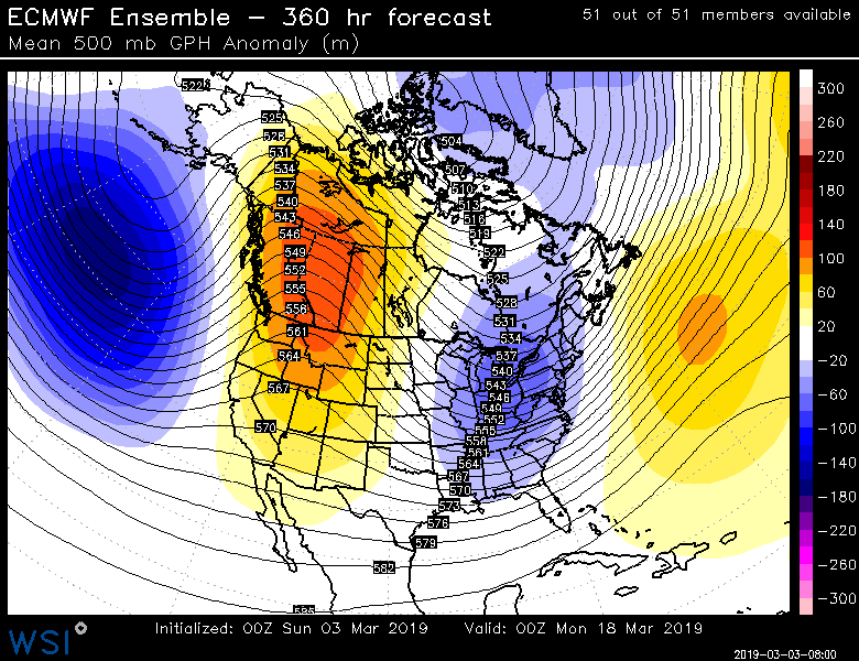
maxwell12103 wrote:What does this mean Amugs? I read somewhere that winter is expected to keep pushing through middle of March now. The accuweather forecast still says that things should become close to seasonal after one more week.
A trough over the east coast (blue) and a PNA spike (yellow colors) which is stormy pattern look - cold air is abundant in CANADA so the possibility is there.
_________________
Mugs
AKA:King: Snow Weenie
Self Proclaimed
WINTER 2014-15 : 55.12" +.02 for 6 coatings (avg. 35")
WINTER 2015-16 Total - 29.8" (Avg 35")
WINTER 2016-17 : 39.5" so far
amugs- Advanced Forecaster - Mod
- Posts : 15130
Reputation : 213
Join date : 2013-01-07
Age : 54
Location : Hillsdale,NJ
Re: Long Range Thread 18.0
![]() by maxwell12103 Sun Mar 03, 2019 6:41 pm
by maxwell12103 Sun Mar 03, 2019 6:41 pm
maxwell12103- Posts : 7
Reputation : 0
Join date : 2019-02-24
Re: Long Range Thread 18.0
![]() by CPcantmeasuresnow Sun Mar 03, 2019 6:56 pm
by CPcantmeasuresnow Sun Mar 03, 2019 6:56 pm
maxwell12103 wrote: I will be so sad if this turns out like last March! Why can't a man get his early spring around here
Simply because that's not historically normal around here. The average high temperature doesn't even hit 70° until May 10th in NYC. Sustained warmth in March would be very unnatural.
CPcantmeasuresnow- Wx Statistician Guru
- Posts : 7274
Reputation : 230
Join date : 2013-01-07
Age : 103
Location : Eastern Orange County, NY
Re: Long Range Thread 18.0
![]() by maxwell12103 Sun Mar 03, 2019 6:57 pm
by maxwell12103 Sun Mar 03, 2019 6:57 pm
maxwell12103- Posts : 7
Reputation : 0
Join date : 2019-02-24
Re: Long Range Thread 18.0
![]() by CPcantmeasuresnow Sun Mar 03, 2019 7:00 pm
by CPcantmeasuresnow Sun Mar 03, 2019 7:00 pm
maxwell12103 wrote:I understand, I was just hoping for seasonal temperatures.
I get it, but even seasonal right now is mid 40's during the day and low 30's at night and that's in the UHI. Much lower N&W.
CPcantmeasuresnow- Wx Statistician Guru
- Posts : 7274
Reputation : 230
Join date : 2013-01-07
Age : 103
Location : Eastern Orange County, NY
Re: Long Range Thread 18.0
![]() by maxwell12103 Sun Mar 03, 2019 7:05 pm
by maxwell12103 Sun Mar 03, 2019 7:05 pm
With this weather, though, there is little to do but get impatient.
maxwell12103- Posts : 7
Reputation : 0
Join date : 2019-02-24
Re: Long Range Thread 18.0
![]() by sroc4 Mon Mar 04, 2019 7:42 am
by sroc4 Mon Mar 04, 2019 7:42 am
First: Temps this week should remain below normal overall as we crescendo with the BN temps Wed through Friday as a deep trough begins to lift out as we head into the weekend.


Second: Regarding snow chances in the short term: Models have a short wave that will enter the West coast of Cali mid week that will head towards the area as we approach the weekend. There are big differences in the 500mb pattern regarding the confluence along the EC as the system approaches. As of now the euro has a much stronger area of confluence and a northern stream short wave suppressing the energy to the south and keeps it sheared out; whereas, the GFS is further north with the N energy allowing a stronger area of vorticity to hold together and allows a weak area of LP to form as the energy exits the coast bringing a brief light area of precip into southern portions of the area. As currently modeled on the GFS it is in the form of snow. Overall this is not a threat for a big snow event by any means but something to watch as we head through the week since there are still huge differences in the upper level energy on the models and cold air is in place as the system approaches. (BTW I put this event up in the scroll on the top of the site. If the threat diminishes over the next few days we will obv take it down)


Third: Looking beyond next weekend we look to head into a warm up period for pretty much all of next week. I don't expect any chances for snow at this time next week at all. Actually I expect a touch of spring and short sleeves perhaps.
That said beyond next week the pattern might just have one final push for a swan song for snow as we approach the 15th-20th time frame. As of now the ensembles, both EPS and GEFS, are hinting at a trough setting up south of the Aleutian Islands and a ridge going up in the PNA region(West coast of the N CONUS into the WC of Canada). Keep in mind this is a long way off and so obviously subject to change, but if those two areas trend stronger there will definitely be some form of a snow threat. Anyway since there is nothing imminently exciting I will likely remain relatively quite and chime in if this weekends weak event starts to grow some legs as we head through the work week.


_________________
"In weather and in life, there's no winning and losing; there's only winning and learning."
WINTER 2012/2013 TOTALS 43.65"WINTER 2017/2018 TOTALS 62.85" WINTER 2022/2023 TOTALS 4.9"
WINTER 2013/2014 TOTALS 64.85"WINTER 2018/2019 TOTALS 14.25" WINTER 2023/2024 TOTALS 13.1"
WINTER 2014/2015 TOTALS 71.20"WINTER 2019/2020 TOTALS 6.35"
WINTER 2015/2016 TOTALS 35.00"WINTER 2020/2021 TOTALS 37.75"
WINTER 2016/2017 TOTALS 42.25"WINTER 2021/2022 TOTALS 31.65"
sroc4- Admin
- Posts : 8441
Reputation : 302
Join date : 2013-01-07
Location : Wading River, LI
Re: Long Range Thread 18.0
![]() by Frank_Wx Mon Mar 04, 2019 8:35 am
by Frank_Wx Mon Mar 04, 2019 8:35 am
The 15th-20th period does look interesting. At that point it is mid-March. I would not expect anything too nuts.
No Godzilla this winter
_________________
_______________________________________________________________________________________________________
CLICK HERE to view NJ Strong Snowstorm Classifications

Frank_Wx- Godzilla Seeker
- Posts : 21308
Reputation : 328
Join date : 2013-01-05
Age : 32
Location : Jersey City, NJ -

Re: Long Range Thread 18.0
![]() by amugs Mon Mar 04, 2019 1:00 pm
by amugs Mon Mar 04, 2019 1:00 pm
EPS harping on this PNA spike and Deep trough over the EC for this 15th -20th period - but we have sun angle etc to fight off

_________________
Mugs
AKA:King: Snow Weenie
Self Proclaimed
WINTER 2014-15 : 55.12" +.02 for 6 coatings (avg. 35")
WINTER 2015-16 Total - 29.8" (Avg 35")
WINTER 2016-17 : 39.5" so far
amugs- Advanced Forecaster - Mod
- Posts : 15130
Reputation : 213
Join date : 2013-01-07
Age : 54
Location : Hillsdale,NJ
Page 33 of 36 • 1 ... 18 ... 32, 33, 34, 35, 36 ![]()