
 Search
Long Range Thread 18.0
Page 34 of 36 •  1 ... 18 ... 33, 34, 35, 36
 ![]()
Re: Long Range Thread 18.0
![]() by Frank_Wx Mon Mar 04, 2019 8:35 am
by Frank_Wx Mon Mar 04, 2019 8:35 am
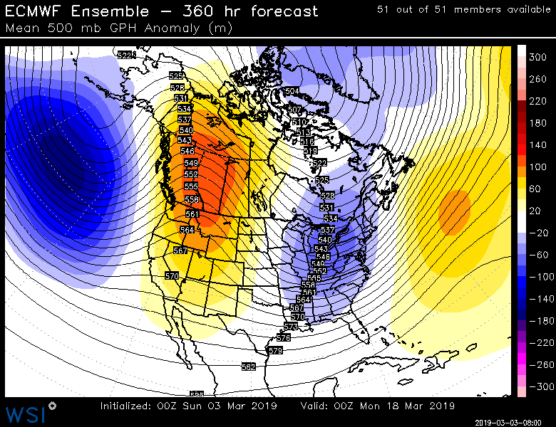
The 15th-20th period does look interesting. At that point it is mid-March. I would not expect anything too nuts.
No Godzilla this winter
Frank_Wx- Godzilla Seeker

- Posts : 21305
Join date : 2013-01-05 -

Re: Long Range Thread 18.0
![]() by amugs Mon Mar 04, 2019 1:00 pm
by amugs Mon Mar 04, 2019 1:00 pm
EPS harping on this PNA spike and Deep trough over the EC for this 15th -20th period - but we have sun angle etc to fight off

amugs- Advanced Forecaster - Mod

- Posts : 15095
Join date : 2013-01-07
Re: Long Range Thread 18.0
![]() by sroc4 Mon Mar 04, 2019 1:38 pm
by sroc4 Mon Mar 04, 2019 1:38 pm
amugs wrote:Green Snow? If this happens th elikly hood goes up!
And where the hell where you all winter - OY VEY!!
Oh and before this Friday and next Tuesdayish
Mugs I didnt even see you had this posted yetserday. Great minds
_________________
"In weather and in life, there's no winning and losing; there's only winning and learning."
WINTER 2012/2013 TOTALS 43.65"WINTER 2017/2018 TOTALS 62.85" WINTER 2022/2023 TOTALS 4.9"
WINTER 2013/2014 TOTALS 64.85"WINTER 2018/2019 TOTALS 14.25" WINTER 2023/2024 TOTALS 13.1"
WINTER 2014/2015 TOTALS 71.20"WINTER 2019/2020 TOTALS 6.35"
WINTER 2015/2016 TOTALS 35.00"WINTER 2020/2021 TOTALS 37.75"
WINTER 2016/2017 TOTALS 42.25"WINTER 2021/2022 TOTALS 31.65"

sroc4- Admin
- Posts : 8354
Reputation : 302
Join date : 2013-01-07
Location : Wading River, LI
Re: Long Range Thread 18.0
![]() by amugs Mon Mar 04, 2019 6:09 pm
by amugs Mon Mar 04, 2019 6:09 pm
sroc4 wrote:amugs wrote:Green Snow? If this happens th elikly hood goes up!
And where the hell where you all winter - OY VEY!!
Oh and before this Friday and next Tuesdayish
Mugs I didnt even see you had this posted yetserday. Great minds
Scott NP my man - the Italian connection!!
When everyone was going crazy about the storm I saw this and said HMMMMMM this look like we can get ourselves one more before CP goes into hibernation!!
_________________
Mugs
AKA:King: Snow Weenie
Self Proclaimed
WINTER 2014-15 : 55.12" +.02 for 6 coatings (avg. 35")
WINTER 2015-16 Total - 29.8" (Avg 35")
WINTER 2016-17 : 39.5" so far

amugs- Advanced Forecaster - Mod
- Posts : 15095
Reputation : 213
Join date : 2013-01-07
Age : 54
Location : Hillsdale,NJ
Re: Long Range Thread 18.0
![]() by SENJsnowman Tue Mar 05, 2019 1:11 pm
by SENJsnowman Tue Mar 05, 2019 1:11 pm
Will try to diagram what I am seeing. Have a small window of time here to do this...brb I hope...
SENJsnowman- Senior Enthusiast

- Posts : 1189
Reputation : 61
Join date : 2017-01-06
Age : 51
Location : Bayville, NJ
Re: Long Range Thread 18.0
![]() by SENJsnowman Tue Mar 05, 2019 2:14 pm
by SENJsnowman Tue Mar 05, 2019 2:14 pm

But most of the models show some kind of light precip over southern NJ for late Friday evening/early Sat morning.
Despite the 540 mb line being located well to the south, the GFS still shows mixing issues at the coast.

And this is supported by a look at 2m air temps...right warm on the coast.

The big question for me is, why does the GFS again have a very warm look for southern NJ?
And, I think answer lie in the fact that as a nice would-be blocking high moves out to sea on Friday, the sourcing of the air switches from cold West-Canada air to warm SW CONUS air, thus bringing surface temps above freezing.
Let's start the analysis with a look at what our air source looks like right now on the GFS. Notice the high pressure center sittin dead in the middle of the country.

And as a result, we are enjoying very cold air at the moment. Perhaps even the coldest air presently on the planet!
The 500mb look shows how nicely the arctic air is getting diverted right towards the NE:

Notice how the high is keeping that warmer air flowing to our south.
And our present 2m temps reflect this.

Now look at the same guidance as the system approaches.
At the surface, we see the HP once again centered in the middle of the Atlantic Ocean (far right of the pic, east of OBX).

And now look at our air source...it's no longer Arctic by any stretch. It's actually cool Pac NW air that is warmed as it is dragged thru the warmer climates and then briefly cooled up north. But you can also clearly that without that high pressure, the warm air to the south easily commingles with the mildy cold air source.

That is a warm look..from the GFS.
SENJsnowman- Senior Enthusiast
- Posts : 1189
Reputation : 61
Join date : 2017-01-06
Age : 51
Location : Bayville, NJ
Re: Long Range Thread 18.0
![]() by SENJsnowman Tue Mar 05, 2019 2:51 pm
by SENJsnowman Tue Mar 05, 2019 2:51 pm

Looking at the 500 level, notice how far north the air source climbs through cold air, before then of course, diving right back down thru that same cold as it descends our way.

And so, of course we get a colder surface solution.

Also a wider precip shield...maybe due to more extreme air temps mixing at the frontal boundary?
SENJsnowman- Senior Enthusiast
- Posts : 1189
Reputation : 61
Join date : 2017-01-06
Age : 51
Location : Bayville, NJ
Re: Long Range Thread 18.0
![]() by GreyBeard Tue Mar 05, 2019 5:11 pm
by GreyBeard Tue Mar 05, 2019 5:11 pm
Where are you posting from, Antarctica?

GreyBeard- Senior Enthusiast
- Posts : 725
Reputation : 34
Join date : 2014-02-12
Location : eastern nassau county
Re: Long Range Thread 18.0
![]() by SENJsnowman Tue Mar 05, 2019 5:20 pm
by SENJsnowman Tue Mar 05, 2019 5:20 pm
GreyBeard wrote:"And as a result, we are enjoying very cold air at the moment. Perhaps even the coldest air presently on the planet!"
Where are you posting from, Antarctica?
Nope.

SENJsnowman- Senior Enthusiast
- Posts : 1189
Reputation : 61
Join date : 2017-01-06
Age : 51
Location : Bayville, NJ
Re: Long Range Thread 18.0
![]() by GreyBeard Tue Mar 05, 2019 5:25 pm
by GreyBeard Tue Mar 05, 2019 5:25 pm
GreyBeard- Senior Enthusiast
- Posts : 725
Reputation : 34
Join date : 2014-02-12
Location : eastern nassau county
Re: Long Range Thread 18.0
![]() by SENJsnowman Tue Mar 05, 2019 5:35 pm
by SENJsnowman Tue Mar 05, 2019 5:35 pm
The arctic cold temperatures in the U.S. are some of the coldest temperatures globally right now."
Posted DIRECTLY above your last quote, Graybeard.
One of thing I've learned (admittedly the hard way) is how hard it can be to graciously bow out of a failed mission.
SENJsnowman- Senior Enthusiast
- Posts : 1189
Reputation : 61
Join date : 2017-01-06
Age : 51
Location : Bayville, NJ
Re: Long Range Thread 18.0
![]() by GreyBeard Tue Mar 05, 2019 5:52 pm
by GreyBeard Tue Mar 05, 2019 5:52 pm

https://www.eldoradoweather.com/climate/world-extremes/world-temp-rainfall-extremes.php
GreyBeard- Senior Enthusiast
- Posts : 725
Reputation : 34
Join date : 2014-02-12
Location : eastern nassau county
Re: Long Range Thread 18.0
![]() by jmanley32 Tue Mar 05, 2019 8:31 pm
by jmanley32 Tue Mar 05, 2019 8:31 pm
gonna have to side with greybeard here in terms of how you put it SENJ, below normal isnt the same as colest temperatures, your very smart I read your analysis so I do not quite understand why you would have written that.GreyBeard wrote:Time to take a bow then
https://www.eldoradoweather.com/climate/world-extremes/world-temp-rainfall-extremes.php

jmanley32- Senior Enthusiast
- Posts : 20535
Reputation : 108
Join date : 2013-12-12
Age : 43
Location : Yonkers, NY
Re: Long Range Thread 18.0
![]() by jmanley32 Tue Mar 05, 2019 8:32 pm
by jmanley32 Tue Mar 05, 2019 8:32 pm
100% correct. Not sure how that could be mistaken even by a novice which neither of you are.GreyBeard wrote:There's a big difference between the most below average and the coldest air on the planet, don't you think?
jmanley32- Senior Enthusiast
- Posts : 20535
Reputation : 108
Join date : 2013-12-12
Age : 43
Location : Yonkers, NY
Re: Long Range Thread 18.0
![]() by SENJsnowman Tue Mar 05, 2019 8:57 pm
by SENJsnowman Tue Mar 05, 2019 8:57 pm
jmanley32 wrote:gonna have to side with greybeard here in terms of how you put it SENJ, below normal isnt the same as colest temperatures, your very smart I read your analysis so I do not quite understand why you would have written that.GreyBeard wrote:Time to take a bow then
https://www.eldoradoweather.com/climate/world-extremes/world-temp-rainfall-extremes.php
Appreciate that jman.
These words are written clearly on the bottom of that headline:
"Below-Average U.S. Temperatures Among the Coldest in World Right Now
The arctic cold temperatures in the U.S. are some of the coldest temperatures globally right now."
So, yeah, if you ONLY look at the headline, it's misleading. But if you look at all of the info on the graphic, it says exactly what I said it says.
I'm equally as perplexed as why that is hard to see/read/grasp/separate from the headline. ???
SENJsnowman- Senior Enthusiast
- Posts : 1189
Reputation : 61
Join date : 2017-01-06
Age : 51
Location : Bayville, NJ
Re: Long Range Thread 18.0
![]() by dkodgis Wed Mar 06, 2019 12:16 pm
by dkodgis Wed Mar 06, 2019 12:16 pm

dkodgis- Senior Enthusiast
- Posts : 2560
Reputation : 98
Join date : 2013-12-29
Re: Long Range Thread 18.0
![]() by dkodgis Wed Mar 06, 2019 12:19 pm
by dkodgis Wed Mar 06, 2019 12:19 pm
dkodgis- Senior Enthusiast
- Posts : 2560
Reputation : 98
Join date : 2013-12-29
Re: Long Range Thread 18.0
![]() by amugs Wed Mar 06, 2019 12:55 pm
by amugs Wed Mar 06, 2019 12:55 pm
Spotless Days
2019 total: 48 days (75%) so far wow!
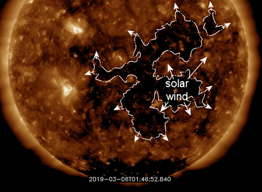
BIG CH = geomagnetic issue seismological speaking ahead
and so it starts the bring back of winter on the great ST Paddy Day and teh PNA spike lasts possibly until teh end of the month dropping the trough into the Eact Coast - where the hell where you all JAN and FEB!!!!


This is the result of the big SOI drop this past two/three weeks and finally the central based nino forcing taking over
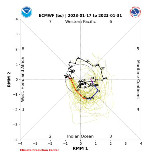
MJO hangs in cold phase

.gif)
PNA

Storm possibilities are there peeps and spring = delayed by these looks at this time.
Nothing we can do but embrace it - we have more snow in March than our true Meteorological winter 12/1 to 3/1
_________________
Mugs
AKA:King: Snow Weenie
Self Proclaimed
WINTER 2014-15 : 55.12" +.02 for 6 coatings (avg. 35")
WINTER 2015-16 Total - 29.8" (Avg 35")
WINTER 2016-17 : 39.5" so far
amugs- Advanced Forecaster - Mod
- Posts : 15095
Reputation : 213
Join date : 2013-01-07
Age : 54
Location : Hillsdale,NJ
Re: Long Range Thread 18.0
![]() by Snow88 Wed Mar 06, 2019 8:33 pm
by Snow88 Wed Mar 06, 2019 8:33 pm
amugs wrote:We went 33 straight days with no sun spots and now have a mini spot but it is one to say the least
Spotless Days
2019 total: 48 days (75%) so far wow!
BIG CH = geomagnetic issue seismological speaking ahead
and so it starts the bring back of winter on the great ST Paddy Day and teh PNA spike lasts possibly until teh end of the month dropping the trough into the Eact Coast - where the hell where you all JAN and FEB!!!!
This is the result of the big SOI drop this past two/three weeks and finally the central based nino forcing taking over
MJO hangs in cold phase
PNA
Storm possibilities are there peeps and spring = delayed by these looks at this time.
Nothing we can do but embrace it - we have more snow in March than our true Meteorological winter 12/1 to 3/1
PNA going positive
EPO falling
AO falling
New Moon
Something big might be on the horizon

Snow88- Senior Enthusiast
- Posts : 2193
Reputation : 4
Join date : 2013-01-09
Age : 35
Location : Brooklyn, NY
Re: Long Range Thread 18.0
![]() by essexcountypete Thu Mar 07, 2019 7:18 am
by essexcountypete Thu Mar 07, 2019 7:18 am
dkodgis wrote:I forgot to add this to the long range thread. I saw a robin today.
On Monday, right after the storm, about 20 robins showed up in our big holly tree to meal out on holly berries. The next morning, there were a dozen very fat robins on the sunny flat roof on the back of my house. Apparently one of the two goshawks that reside in the cemetery across the street also took note of the robins. I went to the shed to put my shovels away yesterday morning, and I turn around to walk out and not six feet in front of me the goshawk lands with a robin in it's claws. It stood there for about 30 seconds until it saw me, then took off with the robin and left a cloud of feathers.
[sorry, this should have been in banter]

essexcountypete- Pro Enthusiast

- Posts : 783
Reputation : 12
Join date : 2013-12-09
Location : Bloomfield, NJ
Re: Long Range Thread 18.0
![]() by Snow88 Sat Mar 09, 2019 10:17 am
by Snow88 Sat Mar 09, 2019 10:17 am
Snow88- Senior Enthusiast
- Posts : 2193
Reputation : 4
Join date : 2013-01-09
Age : 35
Location : Brooklyn, NY
Re: Long Range Thread 18.0
![]() by sroc4 Sat Mar 09, 2019 11:32 am
by sroc4 Sat Mar 09, 2019 11:32 am
Snow88 wrote:PNA still looks great as we head into mid March
Agreed. As long as the current trends cont we will most likely be tracking at least 1-2 more snow chances. Big or small, interior coast all still up in the air but someone on this board should see snow
_________________
"In weather and in life, there's no winning and losing; there's only winning and learning."
WINTER 2012/2013 TOTALS 43.65"WINTER 2017/2018 TOTALS 62.85" WINTER 2022/2023 TOTALS 4.9"
WINTER 2013/2014 TOTALS 64.85"WINTER 2018/2019 TOTALS 14.25" WINTER 2023/2024 TOTALS 13.1"
WINTER 2014/2015 TOTALS 71.20"WINTER 2019/2020 TOTALS 6.35"
WINTER 2015/2016 TOTALS 35.00"WINTER 2020/2021 TOTALS 37.75"
WINTER 2016/2017 TOTALS 42.25"WINTER 2021/2022 TOTALS 31.65"
sroc4- Admin
- Posts : 8354
Reputation : 302
Join date : 2013-01-07
Location : Wading River, LI


skinsfan1177- Senior Enthusiast
- Posts : 4485
Reputation : 35
Join date : 2013-01-07
Age : 46
Location : Point Pleasant Boro
Re: Long Range Thread 18.0
![]() by Irish Sat Mar 09, 2019 9:42 pm
by Irish Sat Mar 09, 2019 9:42 pm

Irish- Pro Enthusiast
- Posts : 788
Reputation : 19
Join date : 2019-01-16
Age : 45
Location : Old Bridge, NJ
Re: Long Range Thread 18.0
![]() by Grselig Sun Mar 10, 2019 9:28 am
by Grselig Sun Mar 10, 2019 9:28 am
skinsfan1177 wrote:Look at that ridge out west
Time frame is the 20th so it’s pretty far out for any forecast. But there is at least potential.

Grselig- Senior Enthusiast
- Posts : 1408
Reputation : 140
Join date : 2013-03-04
Age : 54
Location : Wayne NJ
Re: Long Range Thread 18.0
![]() by billg315 Sun Mar 10, 2019 11:59 am
by billg315 Sun Mar 10, 2019 11:59 am
Irish wrote:I'm seeing all warm temps on TWC. Or is that because it's too far out?
This coming 5-7 day period is pretty warm, or at least normal-to-above. It’s the week beyond that where there is good potential for below normal, colder air to set up shop for a few days.

billg315- Advanced Forecaster - Mod
- Posts : 4483
Reputation : 185
Join date : 2015-01-24
Age : 50
Location : Flemington, NJ
Re: Long Range Thread 18.0
![]() by jmanley32 Sun Mar 10, 2019 1:51 pm
by jmanley32 Sun Mar 10, 2019 1:51 pm
Can the coastal areas or even 15-20 miles inland see any meaningful snow, i mean yes it has happened but with day light savings and sun angle I would think it would have to all fall at night and be heavy. Honestly I would rather spring come, but if we can get one really good storm I will wait. Hoping by april we go into full spring.billg315 wrote:Irish wrote:I'm seeing all warm temps on TWC. Or is that because it's too far out?
This coming 5-7 day period is pretty warm, or at least normal-to-above. It’s the week beyond that where there is good potential for below normal, colder air to set up shop for a few days.
jmanley32- Senior Enthusiast
- Posts : 20535
Reputation : 108
Join date : 2013-12-12
Age : 43
Location : Yonkers, NY
Page 34 of 36 • 1 ... 18 ... 33, 34, 35, 36 ![]()