January 19th-20th: 1st Call Snow Map
+49
Taffy
mako460
Zhukov1945
Joe Snow
Snow88
1190ftalt
2004blackwrx
lglickman1
Dtone
Fededle22
ruggerij
Artechmetals
Radz
brownie
WeatherBob
Adrianf
Grselig
frank 638
hyde345
algae888
jimv45
rb924119
RJB8525
DAYBLAZER
emokid51783
SENJsnowman
Scullybutcher
docstox12
mmanisca
oldtimer
mwilli5783
bobjohnsonforthehall
sroc4
Irish
snowlover 12345
gigs68
skinsfan1177
nutleyblizzard
CPcantmeasuresnow
Vinnydula
heehaw453
aiannone
HectorO
amugs
jmanley32
Dunnzoo
weatherwatchermom
billg315
Frank_Wx
53 posters
Page 1 of 18
Page 1 of 18 • 1, 2, 3 ... 9 ... 18 
 January 19th-20th: 1st Call Snow Map
Our first major winter storm event of the season carries a lot of uncertainty. For starters, there is little agreement among guidance on the exact track of the low pressure system. Most of this is due to the differences at the 500mb level with respect to the southern stream energy which should be fully sampled on tonight's 00z model runs.
Take the last 3 runs of the GFS OP for example.
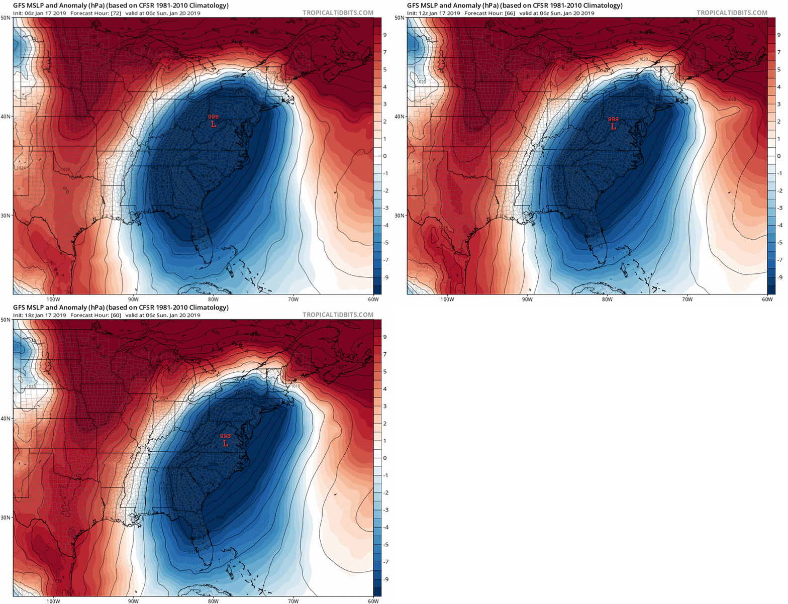
The low pressure center is gradually shifting more S&E late Saturday night / early Sunday morning. This is a critical point because it will ultimately determine the extent of the WAA and how far north it gets. Fortunately the banana High to the north, there due to a ridge break from the -EPO, will prevent this system from being a full-on cutter. Something we have been use to this winter.
One reason the GFS and other models seem to be trending a little more S&E each consecutive run is because of a more positively tilted trough. Notice the latest trend between the 12z and 18z GFS.
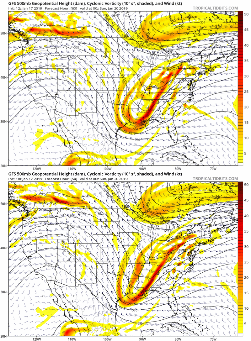
See how heights are flatter over the Metro area?
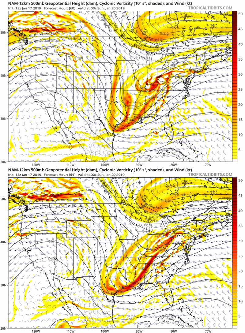
This is also evident on the NAM.
Based off the latest trends and what I expect models to do later tonight and tomorrow, here is my 1st call snow map.
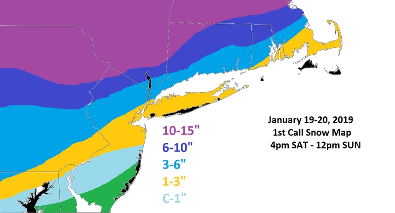
I think there is a chance the 3-6" marker can move into CNJ, NYC, and LI but I am not buying into that much accumulation when I look at the temperature profiles (850mb, 925mb, and Surface). The mid-levels warm up way too quickly because of the initial track of the primary into the southwestern Mid-Atlantic. Because ice accretion carries significant impact I've decided to not map an "ice map" yet for this system. I will outline an area tomorrow of where I think icing could be a major concern. Right now, I am thinking it will be N&W of I-95, the same areas getting hit with at least 6" of snow. Between the snow and ice there could be very hazardous living conditions with scattered power outages. Please be careful.
I'm also not buying into any back-end snow just yet. I know that opportunity exists because of some phasing that occurs with the PV. There are simply too many unknowns right now. Most likely I will have a 2nd call snow map tomorrow.
Take the last 3 runs of the GFS OP for example.

The low pressure center is gradually shifting more S&E late Saturday night / early Sunday morning. This is a critical point because it will ultimately determine the extent of the WAA and how far north it gets. Fortunately the banana High to the north, there due to a ridge break from the -EPO, will prevent this system from being a full-on cutter. Something we have been use to this winter.
One reason the GFS and other models seem to be trending a little more S&E each consecutive run is because of a more positively tilted trough. Notice the latest trend between the 12z and 18z GFS.

See how heights are flatter over the Metro area?
This is also evident on the NAM.

Based off the latest trends and what I expect models to do later tonight and tomorrow, here is my 1st call snow map.

I think there is a chance the 3-6" marker can move into CNJ, NYC, and LI but I am not buying into that much accumulation when I look at the temperature profiles (850mb, 925mb, and Surface). The mid-levels warm up way too quickly because of the initial track of the primary into the southwestern Mid-Atlantic. Because ice accretion carries significant impact I've decided to not map an "ice map" yet for this system. I will outline an area tomorrow of where I think icing could be a major concern. Right now, I am thinking it will be N&W of I-95, the same areas getting hit with at least 6" of snow. Between the snow and ice there could be very hazardous living conditions with scattered power outages. Please be careful.
I'm also not buying into any back-end snow just yet. I know that opportunity exists because of some phasing that occurs with the PV. There are simply too many unknowns right now. Most likely I will have a 2nd call snow map tomorrow.
_________________
_______________________________________________________________________________________________________
CLICK HERE to view NJ Strong Snowstorm Classifications
 Re: January 19th-20th: 1st Call Snow Map
Looks good Frank. Well maybe not “good” for some, but accurate.

billg315- Advanced Forecaster - Mod

- Posts : 4483
Reputation : 185
Join date : 2015-01-24
Age : 50
Location : Flemington, NJ
 Re: January 19th-20th: 1st Call Snow Map
syosnow94 wrote:Yeah looks “GREAT”. If you’re a masochist. Literally if this verifies with how the rest of the winter has gone we will be looking at 20”+ south of me 20”+ north of me 20”+ west of me and since there is no east that’s it. Absolutely incredible kick in the you k ow what. TWC agrees its unrealhow depressing and to boot when everyone else is off from school on Monday we have to go because of construction delays at the beginning of year..so bummed..hope the tables turn for the next chance

weatherwatchermom- Senior Enthusiast

- Posts : 3793
Reputation : 78
Join date : 2014-11-25
Location : Hazlet Township, NJ
 Re: January 19th-20th: 1st Call Snow Map
Syos, sad to say, barring a real big change in models in the next 24 hours, I think 80% of the people on this board will be disappointed in the outcome.

billg315- Advanced Forecaster - Mod

- Posts : 4483
Reputation : 185
Join date : 2015-01-24
Age : 50
Location : Flemington, NJ
 Re: January 19th-20th: 1st Call Snow Map
Thank you for the write up Frank..sad but appreciate the explanation

weatherwatchermom- Senior Enthusiast

- Posts : 3793
Reputation : 78
Join date : 2014-11-25
Location : Hazlet Township, NJ
 Re: January 19th-20th: 1st Call Snow Map
Are we still going to freeze up overnight Sunday into Monday?

weatherwatchermom- Senior Enthusiast

- Posts : 3793
Reputation : 78
Join date : 2014-11-25
Location : Hazlet Township, NJ
 Re: January 19th-20th: 1st Call Snow Map
. Of course we will there will be no moisture or storm so it will get cold. Then by Wednesday there will be another storm but we will be in the 40s. Then we will get cold again and next weekends potential will screw us againweatherwatchermom wrote:Are we still going to freeze up overnight Sunday into Monday?
Guest- Guest
 Re: January 19th-20th: 1st Call Snow Map
weatherwatchermom wrote:Are we still going to freeze up overnight Sunday into Monday?
Anything liquid still around Sunday afternoon (snow, slush, puddles) will be solid ice by Sunday night. Going down to near Zero Sunday night.

billg315- Advanced Forecaster - Mod

- Posts : 4483
Reputation : 185
Join date : 2015-01-24
Age : 50
Location : Flemington, NJ
 Re: January 19th-20th: 1st Call Snow Map
thank youbillg315 wrote:weatherwatchermom wrote:Are we still going to freeze up overnight Sunday into Monday?
Anything liquid still around Sunday afternoon (snow, slush, puddles) will be solid ice by Sunday night. Going down to near Zero Sunday night.

weatherwatchermom- Senior Enthusiast

- Posts : 3793
Reputation : 78
Join date : 2014-11-25
Location : Hazlet Township, NJ
 Re: January 19th-20th: 1st Call Snow Map
syosnow94 wrote:Yeah looks “GREAT”. If you’re a masochist. Literally if this verifies with how the rest of the winter has gone we will be looking at 20”+ south of me 20”+ north of me 20”+ west of me and since there is no east that’s it. Absolutely incredible kick in the you k ow what. TWC agrees its unreal
OMG "Harper" kiss of death right there if you're a Mets fan! lol
_________________
Janet
Snowfall winter of 2023-2024 17.5"
Snowfall winter of 2022-2023 6.0"
Snowfall winter of 2021-2022 17.6" 1" sleet 2/25/22
Snowfall winter of 2020-2021 51.1"
Snowfall winter of 2019-2020 8.5"
Snowfall winter of 2018-2019 25.1"
Snowfall winter of 2017-2018 51.9"
Snowfall winter of 2016-2017 45.6"
Snowfall winter of 2015-2016 29.5"
Snowfall winter of 2014-2015 50.55"
Snowfall winter of 2013-2014 66.5"
Dunnzoo- Senior Enthusiast - Mod

- Posts : 4905
Reputation : 68
Join date : 2013-01-11
Age : 62
Location : Westwood, NJ
 Re: January 19th-20th: 1st Call Snow Map
Thanks Frank, I will take my 3-6 and will see what your thinking is on the ice threat tomorrow, from what I have seen I think I will be in this threat area which isn't good but a experience I have not had except may when I was growing up in CT.

jmanley32- Senior Enthusiast

- Posts : 20535
Reputation : 108
Join date : 2013-12-12
Age : 43
Location : Yonkers, NY
 Re: January 19th-20th: 1st Call Snow Map
Good call Frank and thanks for sharing.
The ice is gonna keep the WSW up for my area and others not the snow accumulations. We need 6 plus for that.
The ice is gonna keep the WSW up for my area and others not the snow accumulations. We need 6 plus for that.
_________________
Mugs
AKA:King: Snow Weenie
Self Proclaimed
WINTER 2014-15 : 55.12" +.02 for 6 coatings (avg. 35")
WINTER 2015-16 Total - 29.8" (Avg 35")
WINTER 2016-17 : 39.5" so far

amugs- Advanced Forecaster - Mod

- Posts : 15095
Reputation : 213
Join date : 2013-01-07
Age : 54
Location : Hillsdale,NJ
 Re: January 19th-20th: 1st Call Snow Map
Yeah mugs I agree, I looked up your location and we line up if you go just a little south of east on a straight line from you to the hudson and across we meet. I think the ice will be highest in the 3-6 area and the southern part of the 6+ area. Maybe I am wrong but thats my thinking.amugs wrote:Good call Frank and thanks for sharing.
The ice is gonna keep the WSW up for my area and others not the snow accumulations. We need 6 plus for that.

jmanley32- Senior Enthusiast

- Posts : 20535
Reputation : 108
Join date : 2013-12-12
Age : 43
Location : Yonkers, NY
 Re: January 19th-20th: 1st Call Snow Map
Man, Bloomingdale is literally on the border of the 3-6 and 6-12 line.

HectorO- Pro Enthusiast

- Posts : 962
Reputation : 27
Join date : 2013-01-11
 Re: January 19th-20th: 1st Call Snow Map
I saw some videos on YouTube of what it looked like after 0.5 inch ice and it was really really bad. The nws has some spots including my area on their experimental ice map along with several models having more than 0.5 So I couldn't even imagine. Smart your not making a map right away frank its a really bad scenario if happened and you wanna be sure your as close to right as possible. Its def be talked about in the general community so its not just models showing the usual bogus ice.

jmanley32- Senior Enthusiast

- Posts : 20535
Reputation : 108
Join date : 2013-12-12
Age : 43
Location : Yonkers, NY
 Re: January 19th-20th: 1st Call Snow Map
Apparently NAM coming in south and east
_________________
-Alex Iannone-

aiannone- Senior Enthusiast - Mod

- Posts : 4815
Reputation : 92
Join date : 2013-01-07
Location : Saint James, LI (Northwest Suffolk Co.)
 Re: January 19th-20th: 1st Call Snow Map
NAM much further se this 0Z run. 850s cooler. So far so good.
heehaw453- Advanced Forecaster

- Posts : 3906
Reputation : 86
Join date : 2014-01-20
Location : Bedminster Township, PA Elevation 600' ASL
 Re: January 19th-20th: 1st Call Snow Map
Nam your pulling me back in

Vinnydula- Pro Enthusiast

- Posts : 778
Reputation : 8
Join date : 2013-12-12
Location : Dobbs ferry
 Re: January 19th-20th: 1st Call Snow Map
heehaw453 wrote:NAM much further se this 0Z run. 850s cooler. So far so good.
That's the word so far, plus a better front end dump of snow for most above I78

CPcantmeasuresnow- Wx Statistician Guru

- Posts : 7274
Reputation : 230
Join date : 2013-01-07
Age : 103
Location : Eastern Orange County, NY
 Re: January 19th-20th: 1st Call Snow Map
Wow! NAM looks to be a good 100 miles SE from 18z Much colder run!

nutleyblizzard- Senior Enthusiast

- Posts : 1954
Reputation : 41
Join date : 2014-01-30
Age : 58
Location : Nutley, new jersey
 Re: January 19th-20th: 1st Call Snow Map
This ice and snow threat combo is no joke, and forcasting winds gusting to 30-40mph NOT GOOD. I have not seen all of the parameters at significant before.
https://www.weather.gov/media/okx/Briefings/WxBriefing_FB.pdf
https://www.weather.gov/media/okx/Briefings/WxBriefing_FB.pdf

jmanley32- Senior Enthusiast

- Posts : 20535
Reputation : 108
Join date : 2013-12-12
Age : 43
Location : Yonkers, NY
 Re: January 19th-20th: 1st Call Snow Map
Yes. This NAM run be completely frozen 78 N. Surface temperatures remain in mid 20s. Much more snow too. I’d sign up for that run right now.
heehaw453- Advanced Forecaster

- Posts : 3906
Reputation : 86
Join date : 2014-01-20
Location : Bedminster Township, PA Elevation 600' ASL
 Re: January 19th-20th: 1st Call Snow Map
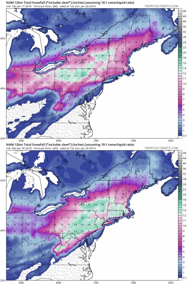
Oh baby 12km NAM snow map! But it looks like major icing still.

jmanley32- Senior Enthusiast

- Posts : 20535
Reputation : 108
Join date : 2013-12-12
Age : 43
Location : Yonkers, NY

skinsfan1177- Senior Enthusiast

- Posts : 4485
Reputation : 35
Join date : 2013-01-07
Age : 46
Location : Point Pleasant Boro
Page 1 of 18 • 1, 2, 3 ... 9 ... 18 
Page 1 of 18
Permissions in this forum:
You cannot reply to topics in this forum|
|
|

 Home
Home
