
 Search
January 19th-20th: 1st Call Snow Map
Page 6 of 18 •  1 ... 5, 6, 7 ... 12 ... 18
 ![]()
Re: January 19th-20th: 1st Call Snow Map
![]() by DAYBLAZER Fri Jan 18, 2019 11:28 am
by DAYBLAZER Fri Jan 18, 2019 11:28 am
sroc4 wrote:Im holding steady for now with the colder NAM soln. NAM insisted that last nights little clipper would stay all snow for LI whereas pretty much all others remained warm. Im still flurrying now when it should have transitioned to rain by now.
You know, I was JUST thinking about this very thing this morning. Most, if not all models besides the NAM, had the clipper producing rain anywhere south of I-78 by 1-2 AM. In reality, the snow was basically area-wide, with minimal changeover at the very end on the immediate coast.
Could this perhaps be a signal moving into this next storm? It may be wishful thinking, but I would love if any more experienced members would chime in on this.
DAYBLAZER- Posts : 228
Join date : 2017-03-12
Re: January 19th-20th: 1st Call Snow Map
![]() by rb924119 Fri Jan 18, 2019 11:35 am
by rb924119 Fri Jan 18, 2019 11:35 am
1. NAM largely held serve
2. Hi-res RGEM and HRDPS are both still at their extended ranges and love to amplify storms like their parent model, GEM with a warm bias
3. The SREFs came in notably COLDER, even than their previous run, which, as I’ve stated multiple times, is a serious red flag to be on the lookout for colder solutions
4. With such a tight thermal gradient and inherent model wobbles, aside from the SREFs, NOTHING HAS TRENDED ANYWHERE today. Typical wobbles at this range from run to run are anywhere from 10-40 miles with surface tracks, and with such a tight thermal gradient these changes are exacerbated.
5. I’ll be looking at the Euro and UKMET, but other than that, I believe GFS and GEM are too warm too quick and am throwing them out
rb924119- Meteorologist

- Posts : 6928
Join date : 2013-02-06
Re: January 19th-20th: 1st Call Snow Map
![]() by jimv45 Fri Jan 18, 2019 11:35 am
by jimv45 Fri Jan 18, 2019 11:35 am
jimv45- Senior Enthusiast

- Posts : 1168
Reputation : 36
Join date : 2013-09-20
Location : Hopewell jct.
Re: January 19th-20th: 1st Call Snow Map
![]() by HectorO Fri Jan 18, 2019 11:45 am
by HectorO Fri Jan 18, 2019 11:45 am
CPcantmeasuresnow wrote:Frank_Wx wrote:The latest GFS is very warm. It tracks the low actually N&W of NYC. Everyone is raining.
Well I'm getting to the point where I don't believe any run on any model for this storm. I never bought the colder runs and I'm not buying this one either.
Since a lot of the previous runs have had over a half inch of ice for many areas bring on the rain over that.


I agree, the hell with this storm if what it's going to produce is a all that damn ice. Mother nature can keep it and just give us rain instead. A house with my wife 3 pets and no generator. I do not need a power outage. I have a fireplace, but that will only help so much.

HectorO- Pro Enthusiast

- Posts : 962
Reputation : 27
Join date : 2013-01-11
Re: January 19th-20th: 1st Call Snow Map
![]() by DAYBLAZER Fri Jan 18, 2019 11:49 am
by DAYBLAZER Fri Jan 18, 2019 11:49 am
rb924119 wrote:3. The SREFs came in notably COLDER, even than their previous run, which, as I’ve stated multiple times, is a serious red flag to be on the lookout for colder solutions
Hi rb, is there any map you could post that shows the SREFs? Or could you or anyone else provide a brief insight into the function of this particular model? Has it performed well in predicting previous storms? It's one that I am pretty unfamiliar with.

DAYBLAZER- Posts : 228
Reputation : 20
Join date : 2017-03-12
Location : Hopatcong, NJ Sussex County
Re: January 19th-20th: 1st Call Snow Map
![]() by rb924119 Fri Jan 18, 2019 11:51 am
by rb924119 Fri Jan 18, 2019 11:51 am
One last point, seeing the GFS Ensembles consistently significantly colder and snowier than the Op is yet another red flag to me that it’s off it’s rocker. We shall see what the next 24 hours hold.
rb924119- Meteorologist
- Posts : 6928
Reputation : 194
Join date : 2013-02-06
Age : 32
Location : Greentown, Pa
Re: January 19th-20th: 1st Call Snow Map
![]() by algae888 Fri Jan 18, 2019 11:53 am
by algae888 Fri Jan 18, 2019 11:53 am

algae888- Advanced Forecaster

- Posts : 5311
Reputation : 46
Join date : 2013-02-05
Age : 62
Location : mt. vernon, new york
Re: January 19th-20th: 1st Call Snow Map
![]() by rb924119 Fri Jan 18, 2019 11:56 am
by rb924119 Fri Jan 18, 2019 11:56 am
DAYBLAZER wrote:rb924119 wrote:3. The SREFs came in notably COLDER, even than their previous run, which, as I’ve stated multiple times, is a serious red flag to be on the lookout for colder solutions
Hi rb, is there any map you could post that shows the SREFs? Or could you or anyone else provide a brief insight into the function of this particular model? Has it performed well in predicting previous storms? It's one that I am pretty unfamiliar with.
I can’t readily post images, but the SREFs are basically the NAM’s ensemble, just like the GFS and Euro have their ensembles. They have scored coups before, but generally are over-amplified. That’s why I made that point you quoted. If they are trending opposite of their known bias, that’s something I notice, and is where I find them highly helpful. I also like the critical thickness plots to help determine precipitation types.
rb924119- Meteorologist
- Posts : 6928
Reputation : 194
Join date : 2013-02-06
Age : 32
Location : Greentown, Pa
Re: January 19th-20th: 1st Call Snow Map
![]() by jmanley32 Fri Jan 18, 2019 11:57 am
by jmanley32 Fri Jan 18, 2019 11:57 am

jmanley32- Senior Enthusiast
- Posts : 20535
Reputation : 108
Join date : 2013-12-12
Age : 43
Location : Yonkers, NY
Re: January 19th-20th: 1st Call Snow Map
![]() by algae888 Fri Jan 18, 2019 11:59 am
by algae888 Fri Jan 18, 2019 11:59 am
algae888- Advanced Forecaster
- Posts : 5311
Reputation : 46
Join date : 2013-02-05
Age : 62
Location : mt. vernon, new york
Re: January 19th-20th: 1st Call Snow Map
![]() by algae888 Fri Jan 18, 2019 12:01 pm
by algae888 Fri Jan 18, 2019 12:01 pm
algae888- Advanced Forecaster
- Posts : 5311
Reputation : 46
Join date : 2013-02-05
Age : 62
Location : mt. vernon, new york
Re: January 19th-20th: 1st Call Snow Map
![]() by jmanley32 Fri Jan 18, 2019 12:01 pm
by jmanley32 Fri Jan 18, 2019 12:01 pm
jmanley32- Senior Enthusiast
- Posts : 20535
Reputation : 108
Join date : 2013-12-12
Age : 43
Location : Yonkers, NY
Re: January 19th-20th: 1st Call Snow Map
![]() by jmanley32 Fri Jan 18, 2019 12:04 pm
by jmanley32 Fri Jan 18, 2019 12:04 pm
al what do you think for us? Do u believe the frz threat or too warm to actually accrue. Or will we see mainly snow or rain and no in betweenalgae888 wrote:Once the low pressure feels the Confluence to our North when it's a over Kentucky or Tennessee There's no way it's going Northeast it's going east Northeast we shall see
This is all over the place.
jmanley32- Senior Enthusiast
- Posts : 20535
Reputation : 108
Join date : 2013-12-12
Age : 43
Location : Yonkers, NY
Re: January 19th-20th: 1st Call Snow Map
![]() by jmanley32 Fri Jan 18, 2019 12:07 pm
by jmanley32 Fri Jan 18, 2019 12:07 pm
jmanley32- Senior Enthusiast
- Posts : 20535
Reputation : 108
Join date : 2013-12-12
Age : 43
Location : Yonkers, NY
Re: January 19th-20th: 1st Call Snow Map
![]() by Frank_Wx Fri Jan 18, 2019 12:07 pm
by Frank_Wx Fri Jan 18, 2019 12:07 pm

_________________
_______________________________________________________________________________________________________
CLICK HERE to view NJ Strong Snowstorm Classifications

Frank_Wx- Godzilla Seeker

- Posts : 21305
Reputation : 328
Join date : 2013-01-05
Age : 32
Location : Jersey City, NJ -

Re: January 19th-20th: 1st Call Snow Map
![]() by sroc4 Fri Jan 18, 2019 12:16 pm
by sroc4 Fri Jan 18, 2019 12:16 pm
DAYBLAZER wrote:sroc4 wrote:Im holding steady for now with the colder NAM soln. NAM insisted that last nights little clipper would stay all snow for LI whereas pretty much all others remained warm. Im still flurrying now when it should have transitioned to rain by now.
You know, I was JUST thinking about this very thing this morning. Most, if not all models besides the NAM, had the clipper producing rain anywhere south of I-78 by 1-2 AM. In reality, the snow was basically area-wide, with minimal changeover at the very end on the immediate coast.
Could this perhaps be a signal moving into this next storm? It may be wishful thinking, but I would love if any more experienced members would chime in on this.
Yeah the forecast busted on QPF in some spots but the NAM did well handling the temp profile. Obv the set up this weekend is very diff but with the type of cold air we have to the north I just dont believe these warmer solns at all.
_________________
"In weather and in life, there's no winning and losing; there's only winning and learning."
WINTER 2012/2013 TOTALS 43.65"WINTER 2017/2018 TOTALS 62.85" WINTER 2022/2023 TOTALS 4.9"
WINTER 2013/2014 TOTALS 64.85"WINTER 2018/2019 TOTALS 14.25" WINTER 2023/2024 TOTALS 13.1"
WINTER 2014/2015 TOTALS 71.20"WINTER 2019/2020 TOTALS 6.35"
WINTER 2015/2016 TOTALS 35.00"WINTER 2020/2021 TOTALS 37.75"
WINTER 2016/2017 TOTALS 42.25"WINTER 2021/2022 TOTALS 31.65"

sroc4- Admin
- Posts : 8354
Reputation : 302
Join date : 2013-01-07
Location : Wading River, LI
Re: January 19th-20th: 1st Call Snow Map
![]() by sroc4 Fri Jan 18, 2019 12:17 pm
by sroc4 Fri Jan 18, 2019 12:17 pm
algae888 wrote:Anybody 15 to 20 miles away from the coast is not going above freezing not in this setup and there's a good chance it doesn't to go above freezing even close to the coast
Agree
_________________
"In weather and in life, there's no winning and losing; there's only winning and learning."
WINTER 2012/2013 TOTALS 43.65"WINTER 2017/2018 TOTALS 62.85" WINTER 2022/2023 TOTALS 4.9"
WINTER 2013/2014 TOTALS 64.85"WINTER 2018/2019 TOTALS 14.25" WINTER 2023/2024 TOTALS 13.1"
WINTER 2014/2015 TOTALS 71.20"WINTER 2019/2020 TOTALS 6.35"
WINTER 2015/2016 TOTALS 35.00"WINTER 2020/2021 TOTALS 37.75"
WINTER 2016/2017 TOTALS 42.25"WINTER 2021/2022 TOTALS 31.65"
sroc4- Admin
- Posts : 8354
Reputation : 302
Join date : 2013-01-07
Location : Wading River, LI
Re: January 19th-20th: 1st Call Snow Map
![]() by algae888 Fri Jan 18, 2019 12:18 pm
by algae888 Fri Jan 18, 2019 12:18 pm
algae888- Advanced Forecaster
- Posts : 5311
Reputation : 46
Join date : 2013-02-05
Age : 62
Location : mt. vernon, new york
Re: January 19th-20th: 1st Call Snow Map
![]() by rb924119 Fri Jan 18, 2019 12:21 pm
by rb924119 Fri Jan 18, 2019 12:21 pm
rb924119- Meteorologist
- Posts : 6928
Reputation : 194
Join date : 2013-02-06
Age : 32
Location : Greentown, Pa
Re: January 19th-20th: 1st Call Snow Map
![]() by Frank_Wx Fri Jan 18, 2019 12:22 pm
by Frank_Wx Fri Jan 18, 2019 12:22 pm
algae888 wrote:The UK also came North it goes from Western Kentucky to Southeast PA then south of Long Island we need that east-northeast Trend when it's over Kentucky hopefully we can get a little more confluence to squeeze this South some
These heights up the coast are extremely amplified. Earlier in the day yesterday and most of Wednesday, it looked like the southern stream was trending to slow down so the TPV would out-run it. Now the two are in-sync. There is phasing on virtually all guidance.

The EURO, GFS, GEFS, and now UKMET are very warm for the area. The Hi-Res models are still trending toward a more northerly storm too.
_________________
_______________________________________________________________________________________________________
CLICK HERE to view NJ Strong Snowstorm Classifications
Frank_Wx- Godzilla Seeker
- Posts : 21305
Reputation : 328
Join date : 2013-01-05
Age : 32
Location : Jersey City, NJ -
Re: January 19th-20th: 1st Call Snow Map
![]() by rb924119 Fri Jan 18, 2019 12:27 pm
by rb924119 Fri Jan 18, 2019 12:27 pm
rb924119 wrote:UKMET actually looks noticeably colder from what can tell so far, but I’m waiting on further maps to confirm.
Ah I see my error here, didn’t realize the forecast time segments changed from the 00z to the 12z lol it is a bit warmer I believe.
rb924119- Meteorologist
- Posts : 6928
Reputation : 194
Join date : 2013-02-06
Age : 32
Location : Greentown, Pa
Re: January 19th-20th: 1st Call Snow Map
![]() by Frank_Wx Fri Jan 18, 2019 12:35 pm
by Frank_Wx Fri Jan 18, 2019 12:35 pm
rb924119 wrote:rb924119 wrote:UKMET actually looks noticeably colder from what can tell so far, but I’m waiting on further maps to confirm.
Ah I see my error here, didn’t realize the forecast time segments changed from the 00z to the 12z lol it is a bit warmer I believe.
A bit?
_________________
_______________________________________________________________________________________________________
CLICK HERE to view NJ Strong Snowstorm Classifications
Frank_Wx- Godzilla Seeker
- Posts : 21305
Reputation : 328
Join date : 2013-01-05
Age : 32
Location : Jersey City, NJ -
Re: January 19th-20th: 1st Call Snow Map
![]() by Guest Fri Jan 18, 2019 12:41 pm
by Guest Fri Jan 18, 2019 12:41 pm
Guest- Guest
Re: January 19th-20th: 1st Call Snow Map
![]() by sroc4 Fri Jan 18, 2019 1:00 pm
by sroc4 Fri Jan 18, 2019 1:00 pm
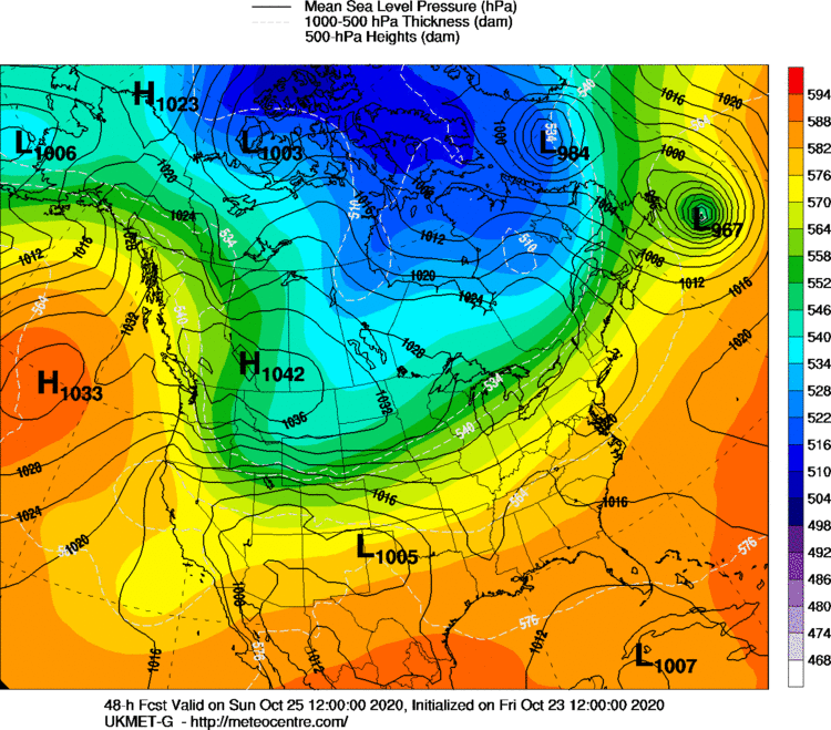
TheAresian wrote:Do the isobars being closer together mean more snow or just stronger winds?
Stronger winds
_________________
"In weather and in life, there's no winning and losing; there's only winning and learning."
WINTER 2012/2013 TOTALS 43.65"WINTER 2017/2018 TOTALS 62.85" WINTER 2022/2023 TOTALS 4.9"
WINTER 2013/2014 TOTALS 64.85"WINTER 2018/2019 TOTALS 14.25" WINTER 2023/2024 TOTALS 13.1"
WINTER 2014/2015 TOTALS 71.20"WINTER 2019/2020 TOTALS 6.35"
WINTER 2015/2016 TOTALS 35.00"WINTER 2020/2021 TOTALS 37.75"
WINTER 2016/2017 TOTALS 42.25"WINTER 2021/2022 TOTALS 31.65"
sroc4- Admin
- Posts : 8354
Reputation : 302
Join date : 2013-01-07
Location : Wading River, LI
Re: January 19th-20th: 1st Call Snow Map
![]() by amugs Fri Jan 18, 2019 1:38 pm
by amugs Fri Jan 18, 2019 1:38 pm
_________________
Mugs
AKA:King: Snow Weenie
Self Proclaimed
WINTER 2014-15 : 55.12" +.02 for 6 coatings (avg. 35")
WINTER 2015-16 Total - 29.8" (Avg 35")
WINTER 2016-17 : 39.5" so far

amugs- Advanced Forecaster - Mod

- Posts : 15095
Reputation : 213
Join date : 2013-01-07
Age : 54
Location : Hillsdale,NJ
Re: January 19th-20th: 1st Call Snow Map
![]() by bobjohnsonforthehall Fri Jan 18, 2019 1:44 pm
by bobjohnsonforthehall Fri Jan 18, 2019 1:44 pm

bobjohnsonforthehall- Posts : 311
Reputation : 19
Join date : 2016-10-02
Location : Flemington NJ
Page 6 of 18 • 1 ... 5, 6, 7 ... 12 ... 18 ![]()
|
|
|