
 Search
Long Range Thread 19.0
Page 7 of 28 •  1 ... 6, 7, 8 ... 17 ... 28
 ![]()
Re: Long Range Thread 19.0
![]() by CPcantmeasuresnow Wed Dec 11, 2019 11:05 am
by CPcantmeasuresnow Wed Dec 11, 2019 11:05 am
heehaw453 wrote:skinsfan1177 wrote:Their split
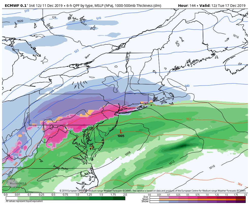
The issue is the primary low's northward progression before it redevelops off coast. Euro has started taking it too far north past Pittsburgh and flooding mid levels with warm air. if we don't get some help from 50/50 low or quasi blocking, then it'll be mostly wet and not white. it's too early yet to know for sure IMO.

A familiar problem and one we won't know the answer to until the weekend at the earliest.
CPcantmeasuresnow- Wx Statistician Guru

- Posts : 7274
Join date : 2013-01-07
Re: Long Range Thread 19.0
![]() by CPcantmeasuresnow Wed Dec 11, 2019 11:14 am
by CPcantmeasuresnow Wed Dec 11, 2019 11:14 am
amugs wrote:DECEMBER TO REMEMBER PEEPS
NEXT STORM BIGLY WISE - DEC 17TH - MY 50TH BDAY!!! CALLING IT.
A Mugzilla - whatever the heck that is but we're getting it!!
Is a Mugzilla a rain storm?
Big doubts about this one already.
CPcantmeasuresnow- Wx Statistician Guru
- Posts : 7274
Join date : 2013-01-07
Re: Long Range Thread 19.0
![]() by hyde345 Wed Dec 11, 2019 11:18 am
by hyde345 Wed Dec 11, 2019 11:18 am

hyde345- Pro Enthusiast

- Posts : 1082
Reputation : 48
Join date : 2013-01-08
Location : Hyde Park, NY
Re: Long Range Thread 19.0
![]() by jmanley32 Wed Dec 11, 2019 11:40 am
by jmanley32 Wed Dec 11, 2019 11:40 am

jmanley32- Senior Enthusiast

- Posts : 20512
Reputation : 108
Join date : 2013-12-12
Age : 42
Location : Yonkers, NY
Re: Long Range Thread 19.0
![]() by amugs Wed Dec 11, 2019 3:03 pm
by amugs Wed Dec 11, 2019 3:03 pm
CPcantmeasuresnow wrote:amugs wrote:DECEMBER TO REMEMBER PEEPS
NEXT STORM BIGLY WISE - DEC 17TH - MY 50TH BDAY!!! CALLING IT.
A Mugzilla - whatever the heck that is but we're getting it!!
Is a Mugzilla a rain storm?
Big doubts about this one already.
Your riding the GFS I see
Stop the negative nanny wise guy look , positiveness or I'll have to move you to sector 14 of OTI!!!
_________________
Mugs
AKA:King: Snow Weenie
Self Proclaimed
WINTER 2014-15 : 55.12" +.02 for 6 coatings (avg. 35")
WINTER 2015-16 Total - 29.8" (Avg 35")
WINTER 2016-17 : 39.5" so far

amugs- Advanced Forecaster - Mod

- Posts : 15093
Reputation : 213
Join date : 2013-01-07
Age : 54
Location : Hillsdale,NJ
Re: Long Range Thread 19.0
![]() by jmanley32 Wed Dec 11, 2019 3:09 pm
by jmanley32 Wed Dec 11, 2019 3:09 pm
jmanley32- Senior Enthusiast
- Posts : 20512
Reputation : 108
Join date : 2013-12-12
Age : 42
Location : Yonkers, NY
Re: Long Range Thread 19.0
![]() by amugs Wed Dec 11, 2019 3:39 pm
by amugs Wed Dec 11, 2019 3:39 pm
Thank God I took down the 70' dead oak tree 2 weeks ago on my side property next to my house!
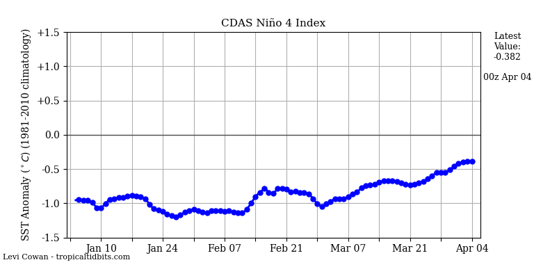
Good SST look here


_________________
Mugs
AKA:King: Snow Weenie
Self Proclaimed
WINTER 2014-15 : 55.12" +.02 for 6 coatings (avg. 35")
WINTER 2015-16 Total - 29.8" (Avg 35")
WINTER 2016-17 : 39.5" so far
amugs- Advanced Forecaster - Mod
- Posts : 15093
Reputation : 213
Join date : 2013-01-07
Age : 54
Location : Hillsdale,NJ
Re: Long Range Thread 19.0
![]() by jmanley32 Wed Dec 11, 2019 3:46 pm
by jmanley32 Wed Dec 11, 2019 3:46 pm
jmanley32- Senior Enthusiast
- Posts : 20512
Reputation : 108
Join date : 2013-12-12
Age : 42
Location : Yonkers, NY
Re: Long Range Thread 19.0
![]() by weatherwatchermom Wed Dec 11, 2019 3:50 pm
by weatherwatchermom Wed Dec 11, 2019 3:50 pm
Mugs what are these chartsamugs wrote:If the EURO scenario comes to fruition then NNJ would crippled period.
Thank God I took down the 70' dead oak tree 2 weeks ago on my side property next to my house!
Good SST look here

weatherwatchermom- Senior Enthusiast
- Posts : 3733
Reputation : 77
Join date : 2014-11-25
Age : 60
Location : Hazlet Township, NJ
Re: Long Range Thread 19.0
![]() by sroc4 Wed Dec 11, 2019 3:56 pm
by sroc4 Wed Dec 11, 2019 3:56 pm
weatherwatchermom wrote:Mugs what are these chartsamugs wrote:If the EURO scenario comes to fruition then NNJ would crippled period.
Thank God I took down the 70' dead oak tree 2 weeks ago on my side property next to my house!
Good SST look here
Sea surface temp anomaly graphs in the tropical pacific. Specifically in the regions that charachterize El Nino or La Nina. Here is the visual of exactly where different Nino index graphs fall. ie: Nino3, Nino 4, etc

_________________
"In weather and in life, there's no winning and losing; there's only winning and learning."
WINTER 2012/2013 TOTALS 43.65"WINTER 2017/2018 TOTALS 62.85" WINTER 2022/2023 TOTALS 4.9"
WINTER 2013/2014 TOTALS 64.85"WINTER 2018/2019 TOTALS 14.25" WINTER 2023/2024 TOTALS 13.1"
WINTER 2014/2015 TOTALS 71.20"WINTER 2019/2020 TOTALS 6.35"
WINTER 2015/2016 TOTALS 35.00"WINTER 2020/2021 TOTALS 37.75"
WINTER 2016/2017 TOTALS 42.25"WINTER 2021/2022 TOTALS 31.65"

sroc4- Admin

- Posts : 8331
Reputation : 301
Join date : 2013-01-07
Location : Wading River, LI
Re: Long Range Thread 19.0
![]() by jmanley32 Wed Dec 11, 2019 8:35 pm
by jmanley32 Wed Dec 11, 2019 8:35 pm
The Euro looks decent for 17th, gives entire area advisory level snow with the potential for a lot more. Lets track!sroc4 wrote:weatherwatchermom wrote:Mugs what are these chartsamugs wrote:If the EURO scenario comes to fruition then NNJ would crippled period.
Thank God I took down the 70' dead oak tree 2 weeks ago on my side property next to my house!
Good SST look here
Sea surface temp anomaly graphs in the tropical pacific. Specifically in the regions that charachterize El Nino or La Nina. Here is the visual of exactly where different Nino index graphs fall. ie: Nino3, Nino 4, etc
jmanley32- Senior Enthusiast
- Posts : 20512
Reputation : 108
Join date : 2013-12-12
Age : 42
Location : Yonkers, NY
Re: Long Range Thread 19.0
![]() by jmanley32 Wed Dec 11, 2019 8:37 pm
by jmanley32 Wed Dec 11, 2019 8:37 pm
jmanley32- Senior Enthusiast
- Posts : 20512
Reputation : 108
Join date : 2013-12-12
Age : 42
Location : Yonkers, NY
Re: Long Range Thread 19.0
![]() by skinsfan1177 Wed Dec 11, 2019 9:42 pm
by skinsfan1177 Wed Dec 11, 2019 9:42 pm

skinsfan1177- Senior Enthusiast
- Posts : 4485
Reputation : 35
Join date : 2013-01-07
Age : 46
Location : Point Pleasant Boro
Re: Long Range Thread 19.0
![]() by sroc4 Wed Dec 11, 2019 10:34 pm
by sroc4 Wed Dec 11, 2019 10:34 pm
skinsfan1177 wrote:I'm not enthused for the 17th threat polar vortex in central Canada screws it up. The timeframe after looks alot better
As modeled now. But it appears to have a negative AO, Neg NAO, and a transient POS PNa. We will have to see how this one evolves before writing it off. My ears are actually perked for this one.
_________________
"In weather and in life, there's no winning and losing; there's only winning and learning."
WINTER 2012/2013 TOTALS 43.65"WINTER 2017/2018 TOTALS 62.85" WINTER 2022/2023 TOTALS 4.9"
WINTER 2013/2014 TOTALS 64.85"WINTER 2018/2019 TOTALS 14.25" WINTER 2023/2024 TOTALS 13.1"
WINTER 2014/2015 TOTALS 71.20"WINTER 2019/2020 TOTALS 6.35"
WINTER 2015/2016 TOTALS 35.00"WINTER 2020/2021 TOTALS 37.75"
WINTER 2016/2017 TOTALS 42.25"WINTER 2021/2022 TOTALS 31.65"
sroc4- Admin
- Posts : 8331
Reputation : 301
Join date : 2013-01-07
Location : Wading River, LI
Re: Long Range Thread 19.0
![]() by skinsfan1177 Thu Dec 12, 2019 5:53 am
by skinsfan1177 Thu Dec 12, 2019 5:53 am
sroc4 wrote:skinsfan1177 wrote:I'm not enthused for the 17th threat polar vortex in central Canada screws it up. The timeframe after looks alot better
As modeled now. But it appears to have a negative AO, Neg NAO, and a transient POS PNa. We will have to see how this one evolves before writing it off. My ears are actually perked for this one.
The block is gone that's what models are showing. I would be concerned about ice in nnj and up that way CNJ and coast is toast. I like the look for a big snow event around the 22 timeframe
skinsfan1177- Senior Enthusiast
- Posts : 4485
Reputation : 35
Join date : 2013-01-07
Age : 46
Location : Point Pleasant Boro
Re: Long Range Thread 19.0
![]() by heehaw453 Thu Dec 12, 2019 6:57 am
by heehaw453 Thu Dec 12, 2019 6:57 am
Agree with Skins the better time frame is after 17th, but this type of setup would be disruptive.
heehaw453- Advanced Forecaster

- Posts : 3906
Reputation : 86
Join date : 2014-01-20
Location : Bedminster Township, PA Elevation 600' ASL
Re: Long Range Thread 19.0
![]() by sroc4 Thu Dec 12, 2019 7:26 am
by sroc4 Thu Dec 12, 2019 7:26 am
skinsfan1177 wrote:sroc4 wrote:skinsfan1177 wrote:I'm not enthused for the 17th threat polar vortex in central Canada screws it up. The timeframe after looks alot better
As modeled now. But it appears to have a negative AO, Neg NAO, and a transient POS PNa. We will have to see how this one evolves before writing it off. My ears are actually perked for this one.
The block is gone that's what models are showing. I would be concerned about ice in nnj and up that way CNJ and coast is toast. I like the look for a big snow event around the 22 timeframe
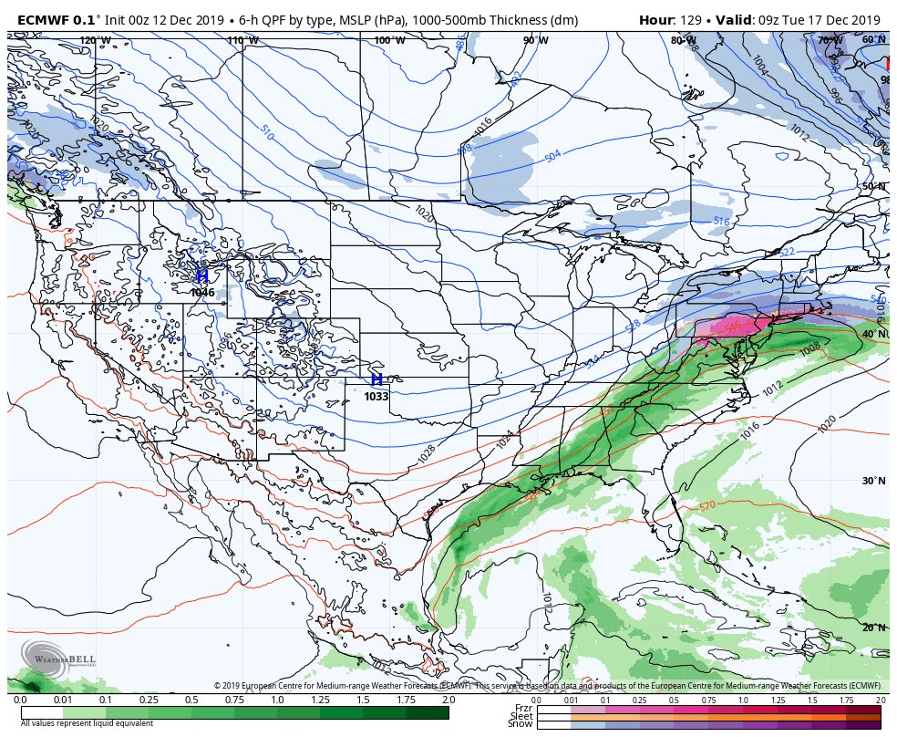
Not sure if we are looking at the same thing Skins but here is what Im referring to.
Currently the blocking is gone however, there is all sorts of energy headed our way for this weekend that will result in a very rainy forecast for the weekend. Because there is no blocking it has no problem cutting and leaving us warm sectored.

However, its this very same system that will head into the N atlantic, in the general vicinity of the 50/50 region, and "break off" the main flow; the result of which will lead to a ridge develop over Greenland(-NAO). Concurrently there will be a ridge developing north of Alaska in the arctic domain(-AO), and as we approach the 17th-18th a +PNA ridge develops out in the western CONUS.
Below are the European ensemble forecast graphs showing that as this weekends storm passes by around tthe 15th the teleconnections begin a reshuffling in there orientation. The GFS ensembles are very similar in both timing and strength graphically.


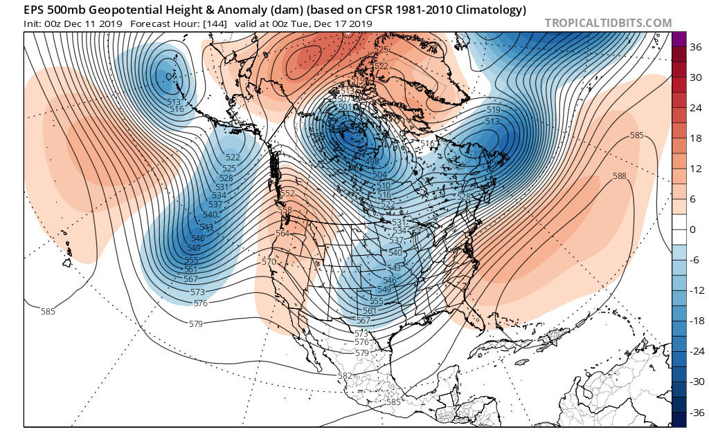
Now graphs are fun to look at but what does it look like on the 500mb maps. Here are both the GEFS and EPS 500mb anomaly maps with all the areas above outlined valid about 8pm Monday the 16th.


You can see the areas discussed setting up resulting in high lat blocking in the AO and NAO domains which forces a lobe of the tropospheric polar vortex(TPV) to head south over the NA continent.
Next two maps are once again the GEFS and EPS espectively, zoomed in a little but the vorticity maps. As we then proceed into the 17th the -AO and -NAO cont to get better established, the TPV takes up residence in N Canada somewhere, and the PNA ridge is in pretty good position with its axis running through Nevada-ish.


Also realize that we have energy coming out of our southern branch, as well as spokes of energy rotating around the TPV and diving into the N Central Plains via the N branch. But the timing, strength and position of these areas has been changing model to model and run to run within a given model. These are the important details that will ultimately determine if we see a system develop and if it does who see what. Right now everything is on the table from nothing to all rain, to mix to snow but a storm is more than likely to threaten the area and IMHO at least some white will be seen even if wet eventually wins out.
The important thing to note here is that this is a signal for an EC storm system. A key point that is starting to come into focus is that the development of high lat blocking is very likely to happen combined with a transient PNA spike. Regarding the energy coming out of the south and diving in from the north....the timing strength and position of said energy will not be realized until we head into the weekend at a minimum. Subtle differences in positioning of some of the key 500mb players will have huge impacts on what happens in reality. I can actually see a scenario develop where we get an over running event initially early on the 17th followed by a second system develop on the 18th if any energy lags behind. There is still so much that can and likely will evolve in the modeling as we have seen time and time again at this lead time.
I would not look past this threat, especially for the NW peeps, as the signal is there. Even the coast has a shot.
Below is a GIF(I hope it works) Follow the blue area in the SE CONUS. Thats our rainy system for Sat/Sun. Follow it up into the N Atlantic and watch is cut off and resultant ridge develop over Greenland at the end of the loop.

Regarding the 22nd threat I 100% agree that this has some serious potential as well. This set up involves a transitioning -NAO towards netural to pos. Historically we have gotten some great storms from that scenario.
Last edited by sroc4 on Thu Dec 12, 2019 7:36 am; edited 1 time in total
_________________
"In weather and in life, there's no winning and losing; there's only winning and learning."
WINTER 2012/2013 TOTALS 43.65"WINTER 2017/2018 TOTALS 62.85" WINTER 2022/2023 TOTALS 4.9"
WINTER 2013/2014 TOTALS 64.85"WINTER 2018/2019 TOTALS 14.25" WINTER 2023/2024 TOTALS 13.1"
WINTER 2014/2015 TOTALS 71.20"WINTER 2019/2020 TOTALS 6.35"
WINTER 2015/2016 TOTALS 35.00"WINTER 2020/2021 TOTALS 37.75"
WINTER 2016/2017 TOTALS 42.25"WINTER 2021/2022 TOTALS 31.65"
sroc4- Admin
- Posts : 8331
Reputation : 301
Join date : 2013-01-07
Location : Wading River, LI
Re: Long Range Thread 19.0
![]() by amugs Thu Dec 12, 2019 7:36 am
by amugs Thu Dec 12, 2019 7:36 am
CAD Signature here and the GFF has ALWAYS struggled in such set ups.

_________________
Mugs
AKA:King: Snow Weenie
Self Proclaimed
WINTER 2014-15 : 55.12" +.02 for 6 coatings (avg. 35")
WINTER 2015-16 Total - 29.8" (Avg 35")
WINTER 2016-17 : 39.5" so far
amugs- Advanced Forecaster - Mod
- Posts : 15093
Reputation : 213
Join date : 2013-01-07
Age : 54
Location : Hillsdale,NJ
Re: Long Range Thread 19.0
![]() by amugs Thu Dec 12, 2019 7:43 am
by amugs Thu Dec 12, 2019 7:43 am
Map from a very good poster from the UK Zac on 33&Rain wx board

eez you don’t see that neat straight lines setup very often.
It’s interesting and one can certainly argue that it is a battle between the +EPO and the Pacific, which doesn’t shape up well for that medium term (but like I said earlier, it’s hard to say how the Aleutian low is sticking when the jet is forecast to retract and there is no +EAMT to back it up).
And the Atlantic which for the medium term looks pretty bloody good. Good for the UK, and good for the US East Coast. Particularly for those who want coastal snowfall.
Whether that holds for a short while or a long while, depends on how the Pacific pans out however. You can thank the -AAM for the chance to get that Eastern US troughing in this instance.
Anyway looks like the potential chances for East Coast snowfall ATM in terms of dates are:
18th-19th December
22nd-24th December
_________________
Mugs
AKA:King: Snow Weenie
Self Proclaimed
WINTER 2014-15 : 55.12" +.02 for 6 coatings (avg. 35")
WINTER 2015-16 Total - 29.8" (Avg 35")
WINTER 2016-17 : 39.5" so far
amugs- Advanced Forecaster - Mod
- Posts : 15093
Reputation : 213
Join date : 2013-01-07
Age : 54
Location : Hillsdale,NJ
Re: Long Range Thread 19.0
![]() by amugs Thu Dec 12, 2019 8:08 am
by amugs Thu Dec 12, 2019 8:08 am
Anthony Masiello
@antmasiello
Deep Arctic Air will return to the rest of the CONUS when the West Pacific Warm Pool starts to reassert itself. Currently, the strong height gradient and zonal wave flux is preventing a more serious showing in the WPO/EPO domain. It can and will get much worse.
_________________
Mugs
AKA:King: Snow Weenie
Self Proclaimed
WINTER 2014-15 : 55.12" +.02 for 6 coatings (avg. 35")
WINTER 2015-16 Total - 29.8" (Avg 35")
WINTER 2016-17 : 39.5" so far
amugs- Advanced Forecaster - Mod
- Posts : 15093
Reputation : 213
Join date : 2013-01-07
Age : 54
Location : Hillsdale,NJ
Re: Long Range Thread 19.0
![]() by CPcantmeasuresnow Thu Dec 12, 2019 8:21 am
by CPcantmeasuresnow Thu Dec 12, 2019 8:21 am
sroc4 wrote:skinsfan1177 wrote:sroc4 wrote:skinsfan1177 wrote:I'm not enthused for the 17th threat polar vortex in central Canada screws it up. The timeframe after looks alot better
As modeled now. But it appears to have a negative AO, Neg NAO, and a transient POS PNa. We will have to see how this one evolves before writing it off. My ears are actually perked for this one.
The block is gone that's what models are showing. I would be concerned about ice in nnj and up that way CNJ and coast is toast. I like the look for a big snow event around the 22 timeframe
Not sure if we are looking at the same thing Skins but here is what Im referring to.
Currently the blocking is gone however, there is all sorts of energy headed our way for this weekend that will result in a very rainy forecast for the weekend. Because there is no blocking it has no problem cutting and leaving us warm sectored.
However, its this very same system that will head into the N atlantic, in the general vicinity of the 50/50 region, and "break off" the main flow; the result of which will lead to a ridge develop over Greenland(-NAO). Concurrently there will be a ridge developing north of Alaska in the arctic domain(-AO), and as we approach the 17th-18th a +PNA ridge develops out in the western CONUS.
Below are the European ensemble forecast graphs showing that as this weekends storm passes by around tthe 15th the teleconnections begin a reshuffling in there orientation. The GFS ensembles are very similar in both timing and strength graphically.
Now graphs are fun to look at but what does it look like on the 500mb maps. Here are both the GEFS and EPS 500mb anomaly maps with all the areas above outlined valid about 8pm Monday the 16th.
You can see the areas discussed setting up resulting in high lat blocking in the AO and NAO domains which forces a lobe of the tropospheric polar vortex(TPV) to head south over the NA continent.
Next two maps are once again the GEFS and EPS espectively, zoomed in a little but the vorticity maps. As we then proceed into the 17th the -AO and -NAO cont to get better established, the TPV takes up residence in N Canada somewhere, and the PNA ridge is in pretty good position with its axis running through Nevada-ish.
Also realize that we have energy coming out of our southern branch, as well as spokes of energy rotating around the TPV and diving into the N Central Plains via the N branch. But the timing, strength and position of these areas has been changing model to model and run to run within a given model. These are the important details that will ultimately determine if we see a system develop and if it does who see what. Right now everything is on the table from nothing to all rain, to mix to snow but a storm is more than likely to threaten the area and IMHO at least some white will be seen even if wet eventually wins out.
The important thing to note here is that this is a signal for an EC storm system. A key point that is starting to come into focus is that the development of high lat blocking is very likely to happen combined with a transient PNA spike. Regarding the energy coming out of the south and diving in from the north....the timing strength and position of said energy will not be realized until we head into the weekend at a minimum. Subtle differences in positioning of some of the key 500mb players will have huge impacts on what happens in reality. I can actually see a scenario develop where we get an over running event initially early on the 17th followed by a second system develop on the 18th if any energy lags behind. There is still so much that can and likely will evolve in the modeling as we have seen time and time again at this lead time.
I would not look past this threat, especially for the NW peeps, as the signal is there. Even the coast has a shot.
Below is a GIF(I hope it works) Follow the blue area in the SE CONUS. Thats our rainy system for Sat/Sun. Follow it up into the N Atlantic and watch is cut off and resultant ridge develop over Greenland at the end of the loop.
Regarding the 22nd threat I 100% agree that this has some serious potential as well. This set up involves a transitioning -NAO towards netural to pos. Historically we have gotten some great storms from that scenario.
Fantastic write up Scott.
Facts, Figures, Diagrams and logic. Even the uneducated like myself can follow this.
I do hate the ice probabilities in these setups, but I'm hoping we can avoid that somehow. However if it means a front end 6 inches I'll take the ice but in a limited quantity.

CPcantmeasuresnow- Wx Statistician Guru
- Posts : 7274
Reputation : 230
Join date : 2013-01-07
Age : 103
Location : Eastern Orange County, NY
Re: Long Range Thread 19.0
![]() by jmanley32 Thu Dec 12, 2019 8:38 am
by jmanley32 Thu Dec 12, 2019 8:38 am
jmanley32- Senior Enthusiast
- Posts : 20512
Reputation : 108
Join date : 2013-12-12
Age : 42
Location : Yonkers, NY
Re: Long Range Thread 19.0
![]() by sroc4 Thu Dec 12, 2019 9:03 am
by sroc4 Thu Dec 12, 2019 9:03 am
jmanley32 wrote:Looks like a aweful lot of things have to go right for this to happen but it's nice to have things to track. The 22nd looks awesome posdibility.
That's always the case Jman for it to work out for anyone who wants a specific outcome in a specific back yard. There is; however, a high probability of a snowstorm in the north east within this time frame given the set up. Its more a matter of where. Mother nature doesnt work on the tiny scales that we do when it comes to details. A matter of 200 miles north or south to a rain snow line means nothing to MN. Someone within the circled area will see a snowstorm of some type between the 16th-19th. Thats a guarantee.

_________________
"In weather and in life, there's no winning and losing; there's only winning and learning."
WINTER 2012/2013 TOTALS 43.65"WINTER 2017/2018 TOTALS 62.85" WINTER 2022/2023 TOTALS 4.9"
WINTER 2013/2014 TOTALS 64.85"WINTER 2018/2019 TOTALS 14.25" WINTER 2023/2024 TOTALS 13.1"
WINTER 2014/2015 TOTALS 71.20"WINTER 2019/2020 TOTALS 6.35"
WINTER 2015/2016 TOTALS 35.00"WINTER 2020/2021 TOTALS 37.75"
WINTER 2016/2017 TOTALS 42.25"WINTER 2021/2022 TOTALS 31.65"
sroc4- Admin
- Posts : 8331
Reputation : 301
Join date : 2013-01-07
Location : Wading River, LI
Re: Long Range Thread 19.0
![]() by SENJsnowman Thu Dec 12, 2019 9:10 am
by SENJsnowman Thu Dec 12, 2019 9:10 am
"good for the US East Coast. Particularly for those who want coastal snowfall"
SENJsnowman- Senior Enthusiast
- Posts : 1186
Reputation : 61
Join date : 2017-01-06
Age : 51
Location : Bayville, NJ
Re: Long Range Thread 19.0
![]() by mwilli Thu Dec 12, 2019 9:38 am
by mwilli Thu Dec 12, 2019 9:38 am
mwilli- Posts : 132
Reputation : 3
Join date : 2019-02-11
Re: Long Range Thread 19.0
![]() by jmanley32 Thu Dec 12, 2019 10:32 am
by jmanley32 Thu Dec 12, 2019 10:32 am
well at least we are in the circle lol. I know exactly what you mean was kinda reiterating the obvious I guess. I'm going to try not to worry bout imby but it's so hard once we reach sr. Long range I no longer sweat it.sroc4 wrote:jmanley32 wrote:Looks like a aweful lot of things have to go right for this to happen but it's nice to have things to track. The 22nd looks awesome posdibility.
That's always the case Jman for it to work out for anyone who wants a specific outcome in a specific back yard. There is; however, a high probability of a snowstorm in the north east within this time frame given the set up. Its more a matter of where. Mother nature doesnt work on the tiny scales that we do when it comes to details. A matter of 200 miles north or south to a rain snow line means nothing to MN. Someone within the circled area will see a snowstorm of some type between the 16th-19th. Thats a guarantee.
jmanley32- Senior Enthusiast
- Posts : 20512
Reputation : 108
Join date : 2013-12-12
Age : 42
Location : Yonkers, NY
Re: Long Range Thread 19.0
![]() by algae888 Thu Dec 12, 2019 10:34 am
by algae888 Thu Dec 12, 2019 10:34 am
Edit. The second most important feature is the strength of the 50/50 low (stronger the more confluence to our north) also something to focus on the next few days of modeling

algae888- Advanced Forecaster
- Posts : 5311
Reputation : 46
Join date : 2013-02-05
Age : 61
Location : mt. vernon, new york
Page 7 of 28 • 1 ... 6, 7, 8 ... 17 ... 28 ![]()
|
|
|