Long Range Thread 19.0
+38
essexcountypete
SoulSingMG
Scullybutcher
phil155
bobjohnsonforthehall
Zhukov1945
dsix85
Radz
lja
Grselig
devsman
DAYBLAZER
Irish
Dunnzoo
jimv45
sabamfa
SENJsnowman
frank 638
heehaw453
skinsfan1177
sroc4
hyde345
CPcantmeasuresnow
Math23x7
nutleyblizzard
rb924119
weatherwatchermom
aiannone
jmanley32
billg315
dkodgis
Snow88
algae888
docstox12
HectorO
mwilli
amugs
Frank_Wx
42 posters
Page 25 of 28
Page 25 of 28 •  1 ... 14 ... 24, 25, 26, 27, 28
 Re: Long Range Thread 19.0
weatherwatchermom wrote:Frank_Wx wrote:Sorry for lack of posts lately. Personal life became busy and also our winter weather pattern is abysmal. After taking a glance at things today I remain pessimistic. The EPS shows a SE ridge in place from February 10th-20th. You just know this pattern will break in time when we are all ready for spring. At that point, I don't see the point of snow if its going to be of the wet kind when you are battling sun angle and surface temps.
Its been a horrific winter. I do not see an end in sight.
so depressing....I try to be a half glass full type of gal..but really need to have an empty glass to survive this horrible snowless winter the last 2 years...side note joined a snow lovers group on FB..I get to live vicariously thru the pictures of others..
Joanne, follow Reed Timmer on FB and Twitter. Since he moved to Colorado, he has been chasing snow storms as well as tornadoes!
Dunnzoo- Senior Enthusiast - Mod

- Posts : 4905
Join date : 2013-01-11
 Re: Long Range Thread 19.0
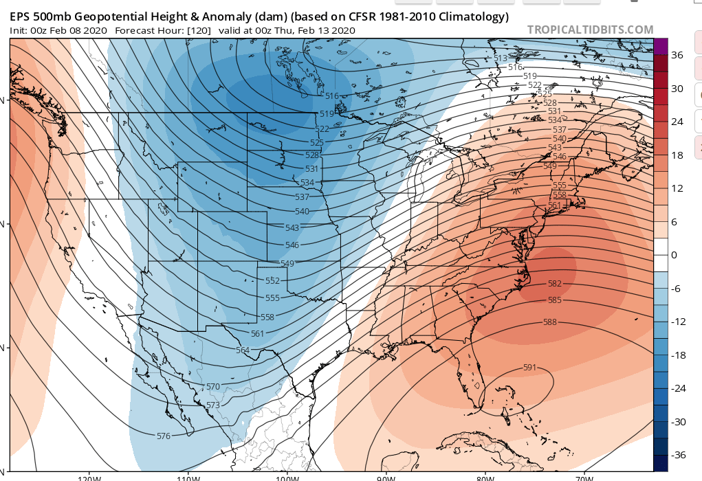
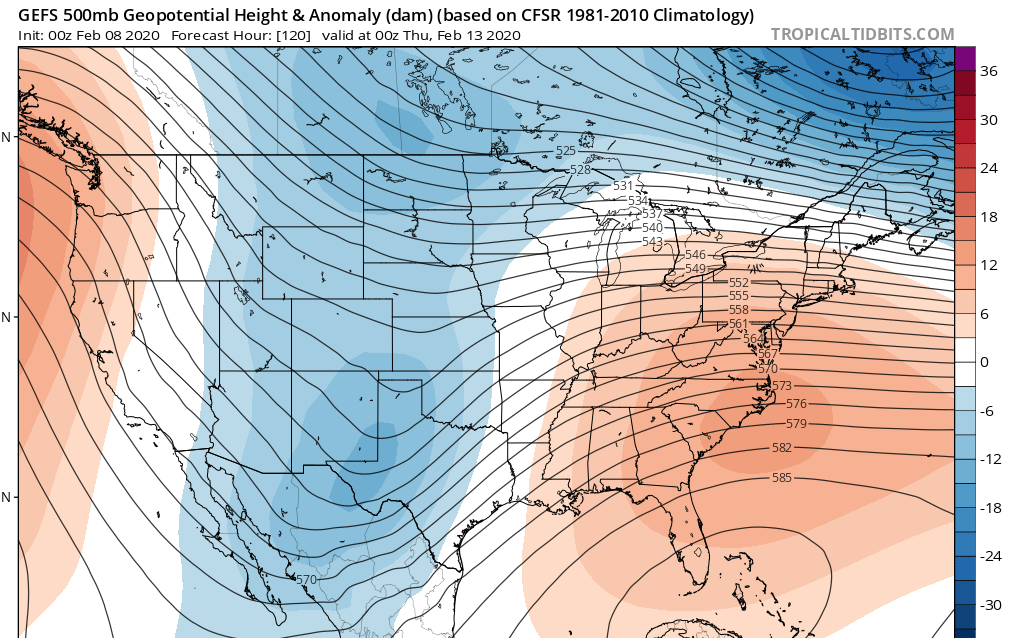
Some of the models are hinting at snow on or before Valentines Day. I urge you to be skeptical of such a solution ATTM.
The bottom line is the ridging on the EPS is much higher up the Eastern US and allows for a southerly flow to warm the column. The GEFS would help to suppress the wave and keep the baroclinic zone favorable for us by keeping the flow more north easterly. Difference is Euro would cut and GFS would allow for a much better chance at something.
fwiw. The GEPS (Canadian Ensembles) is backing up the GFS ensembles and even more aggressive with the suppression.
What has occurred more often than not this year is what I would ask myself. Really take everything else out of the equation.


heehaw453- Advanced Forecaster

- Posts : 3906
Reputation : 86
Join date : 2014-01-20
Location : Bedminster Township, PA Elevation 600' ASL
 Re: Long Range Thread 19.0
heehaw453 wrote:Some of the models are hinting at snow on or before Valentines Day. I urge you to be skeptical of such a solution ATTM.
The bottom line is the ridging on the EPS is much higher up the Eastern US and allows for a southerly flow to warm the column. The GEFS would help to suppress the wave and keep the baroclinic zone favorable for us by keeping the flow more north easterly. Difference is Euro would cut and GFS would allow for a much better chance at something.
fwiw. The GEPS (Canadian Ensembles) is backing up the GFS ensembles and even more aggressive with the suppression.
What has occurred more often than not this year is what I would ask myself. Really take everything else out of the equation.
I'm definitely skeptical what phase is the MJO look to be in at this time

skinsfan1177- Senior Enthusiast

- Posts : 4485
Reputation : 35
Join date : 2013-01-07
Age : 46
Location : Point Pleasant Boro
 Re: Long Range Thread 19.0
GEFS have had a long term cold bias all winter and then warm up the closer we get. I'd expect the same again. Until the pattern actually changes I wouldn't expect anything different than we've had all winter.
Since Dec 22 it's been just a horrific pattern. One of the worst ever seen. The only places in the northeast cashing in this year are upstate NY and NNE. Mikes done okay in Albany with 38 inches so far but that's right about their normal for this point in the season.
I'm getting to the point where I wonder why I bother to look each day.

CPcantmeasuresnow- Wx Statistician Guru

- Posts : 7274
Reputation : 230
Join date : 2013-01-07
Age : 103
Location : Eastern Orange County, NY
 Re: Long Range Thread 19.0
CPcantmeasuresnow wrote:GEFS have had a long term cold bias all winter and then warm up the closer we get. I'd expect the same again. Until the pattern actually changes I wouldn't expect anything different than we've had all winter.
Since Dec 22 it's been just a horrific pattern. One of the worst ever seen. The only places in the northeast cashing in this year are upstate NY and NNE. Mikes done okay in Albany with 38 inches so far but that's right about their normal for this point in the season.
I'm getting to the point where I wonder why I bother to look each day.
I don't know either. Looking for a little hope, although in the end, its nothing. I guess what's winter (or philosophically, life) without a little hope)

Grselig- Senior Enthusiast

- Posts : 1408
Reputation : 140
Join date : 2013-03-04
Age : 54
Location : Wayne NJ
 Re: Long Range Thread 19.0
Grselig wrote:CPcantmeasuresnow wrote:GEFS have had a long term cold bias all winter and then warm up the closer we get. I'd expect the same again. Until the pattern actually changes I wouldn't expect anything different than we've had all winter.
Since Dec 22 it's been just a horrific pattern. One of the worst ever seen. The only places in the northeast cashing in this year are upstate NY and NNE. Mikes done okay in Albany with 38 inches so far but that's right about their normal for this point in the season.
I'm getting to the point where I wonder why I bother to look each day.
I don't know either. Looking for a little hope, although in the end, its nothing. I guess what's winter (or philosophically, life) without a little hope)
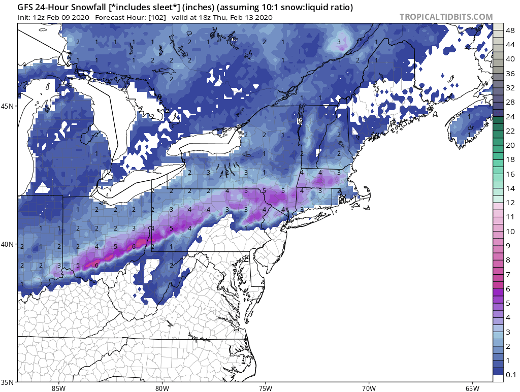
Me three guys. Been a rough one. GFS continues to advertise snow on 2/13 but I believe it'll correct itself in the next 24-36 hours What I'll be looking for is how is deals with the ridge in east coast. Most likely it'll continue to pump the ridge up on the east coast to a point where it's in Quebec. I am expecting precipitation just not the kind we want. I've never wanted to be wrong so bad...
heehaw453- Advanced Forecaster

- Posts : 3906
Reputation : 86
Join date : 2014-01-20
Location : Bedminster Township, PA Elevation 600' ASL
 Re: Long Range Thread 19.0
At this point pretty much giving up on any sustained pattern change to bring us multiple snow chances. Nothing looks appetizing the next two weeks. Final week of Feb. and March still remains but while that time frame delivered two years ago I don’t hold out much hope. So I’m shifting to hoping for that one perfectly timed system that sneaks in between two warm stretches and gives us one good major snowstorm before the flowers come up. Period of March 1-18 is usually a prime candidate for that type of “surprise.”

billg315- Advanced Forecaster - Mod

- Posts : 4483
Reputation : 185
Join date : 2015-01-24
Age : 50
Location : Flemington, NJ
 Re: Long Range Thread 19.0
I’m hoping for something before July 4. I think that’s showing patience and restraint.

dkodgis- Senior Enthusiast

- Posts : 2560
Reputation : 98
Join date : 2013-12-29
 Re: Long Range Thread 19.0
dkodgis wrote:I’m hoping for something before July 4. I think that’s showing patience and restraint.
I always holdout hope until May 10. That's the latest I've seen accumulating snow in this area (May 10, 1977, NYC had a trace, while higher elevations of the HV had over two feet ) and I'm hoping one day to see it again.
Watch for a major pattern change around April 1, followed by a couple of slop storms the first couple weeks of April where we'll all be calculating how much snow we would have had if it was 2-3 weeks earlier.

CPcantmeasuresnow- Wx Statistician Guru

- Posts : 7274
Reputation : 230
Join date : 2013-01-07
Age : 103
Location : Eastern Orange County, NY
 Re: Long Range Thread 19.0
It is snowing here. Pleasant flurrying activity. I guess it is true what they say: the grass is greener over the septic tank. The rest gets a slight coating

dkodgis- Senior Enthusiast

- Posts : 2560
Reputation : 98
Join date : 2013-12-29
 Re: Long Range Thread 19.0
As of 12Z today all guidance has a storm for 2/13.
Most guidance has the low sliding underneath us. Euro is taking the low through Buffalo with that pumped up ridge into Quebec. This will interesting to see in the next 2 days.
Most guidance has the low sliding underneath us. Euro is taking the low through Buffalo with that pumped up ridge into Quebec. This will interesting to see in the next 2 days.
heehaw453- Advanced Forecaster

- Posts : 3906
Reputation : 86
Join date : 2014-01-20
Location : Bedminster Township, PA Elevation 600' ASL
 Re: Long Range Thread 19.0
You can see the GFS and other guidance starting to pump the ridge a bit higher on east coast allowing for the southerly flow. Consequently warmer and more wet solutions. Euro I think is a bit too aggressive with respect to the ridging as it still takes the low through Buffalo and blasts the ridge past Quebec City, CA.
Nah. Split the difference I think between the two and take the low a bit west of us and have the ridging 200-300 miles south/east of where Euro has it. There's not much risk in me saying a wet solution for most in this pattern, but believe that to be the case for 2/13. Maybe NW folks can catch a break, but doubt it.
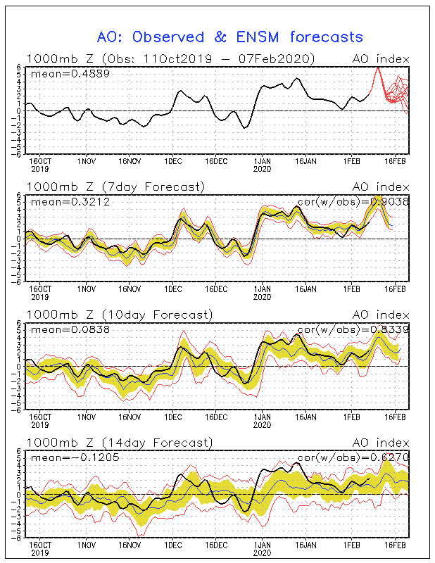
In regards to beyond that the Euro Ensembles still looking tough to produce. -EPO/+NAO/+AO and huge Atlantic ridge. At the end (D10) though the silver lining looked to be a more neutral slightly negative AO. If that's true then maybe open the blinds back up after 2/18 or so. The hostility and consistency of this pattern is unreal. I'm not at all going to be surprised to see this continue quite honestly until it's too late.
Silver lining?

heehaw453- Advanced Forecaster

- Posts : 3906
Reputation : 86
Join date : 2014-01-20
Location : Bedminster Township, PA Elevation 600' ASL
 Re: Long Range Thread 19.0
Is that warmth I see? Yes that wpuld be fine with me and lets keep it that way, lets chalk this up to the record worst winter ever that I can remember knotching a huge 4 inches for the season. Thats gotta be a all time record low no? Stats guys my area ever see less than that?heehaw453 wrote:You can see the GFS and other guidance starting to pump the ridge a bit higher on east coast allowing for the southerly flow. Consequently warmer and more wet solutions. Euro I think is a bit too aggressive with respect to the ridging as it still takes the low through Buffalo and blasts the ridge past Quebec City, CA.
Nah. Split the difference I think between the two and take the low a bit west of us and have the ridging 200-300 miles south/east of where Euro has it. There's not much risk in me saying a wet solution for most in this pattern, but believe that to be the case for 2/13. Maybe NW folks can catch a break, but doubt it.
In regards to beyond that the Euro Ensembles still looking tough to produce. -EPO/+NAO/+AO and huge Atlantic ridge. At the end (D10) though the silver lining looked to be a more neutral slightly negative AO. If that's true then maybe open the blinds back up after 2/18 or so. The hostility and consistency of this pattern is unreal. I'm not at all going to be surprised to see this continue quite honestly until it's too late.
Silver lining?

jmanley32- Senior Enthusiast

- Posts : 20535
Reputation : 108
Join date : 2013-12-12
Age : 43
Location : Yonkers, NY
 Re: Long Range Thread 19.0
jmanley32 wrote:Is that warmth I see? Yes that wpuld be fine with me and lets keep it that way, lets chalk this up to the record worst winter ever that I can remember knotching a huge 4 inches for the season. Thats gotta be a all time record low no? Stats guys my area ever see less than that?heehaw453 wrote:You can see the GFS and other guidance starting to pump the ridge a bit higher on east coast allowing for the southerly flow. Consequently warmer and more wet solutions. Euro I think is a bit too aggressive with respect to the ridging as it still takes the low through Buffalo and blasts the ridge past Quebec City, CA.
Nah. Split the difference I think between the two and take the low a bit west of us and have the ridging 200-300 miles south/east of where Euro has it. There's not much risk in me saying a wet solution for most in this pattern, but believe that to be the case for 2/13. Maybe NW folks can catch a break, but doubt it.
In regards to beyond that the Euro Ensembles still looking tough to produce. -EPO/+NAO/+AO and huge Atlantic ridge. At the end (D10) though the silver lining looked to be a more neutral slightly negative AO. If that's true then maybe open the blinds back up after 2/18 or so. The hostility and consistency of this pattern is unreal. I'm not at all going to be surprised to see this continue quite honestly until it's too late.
Silver lining?
That's incredible wrt 4". I know NYC < 5" too and would be interested to know what Jersey shore folks are at. I'm at 9" and I think some how some way I'll get at least another inch for double digit snowfall before it's over. I certainly haven't experienced single digit since I've been here.
heehaw453- Advanced Forecaster

- Posts : 3906
Reputation : 86
Join date : 2014-01-20
Location : Bedminster Township, PA Elevation 600' ASL
 Re: Long Range Thread 19.0
jmanley32 wrote:Is that warmth I see? Yes that wpuld be fine with me and lets keep it that way, lets chalk this up to the record worst winter ever that I can remember knotching a huge 4 inches for the season. Thats gotta be a all time record low no? Stats guys my area ever see less than that?heehaw453 wrote:You can see the GFS and other guidance starting to pump the ridge a bit higher on east coast allowing for the southerly flow. Consequently warmer and more wet solutions. Euro I think is a bit too aggressive with respect to the ridging as it still takes the low through Buffalo and blasts the ridge past Quebec City, CA.
Nah. Split the difference I think between the two and take the low a bit west of us and have the ridging 200-300 miles south/east of where Euro has it. There's not much risk in me saying a wet solution for most in this pattern, but believe that to be the case for 2/13. Maybe NW folks can catch a break, but doubt it.
In regards to beyond that the Euro Ensembles still looking tough to produce. -EPO/+NAO/+AO and huge Atlantic ridge. At the end (D10) though the silver lining looked to be a more neutral slightly negative AO. If that's true then maybe open the blinds back up after 2/18 or so. The hostility and consistency of this pattern is unreal. I'm not at all going to be surprised to see this continue quite honestly until it's too late.
Silver lining?
You're closest official reporting station is Central Park Jman which currently sits at 4.8 inches for the season. The lowest seasonal ever in NYC is 2.8 inches in 1972/73 and that's in 151 years of record keeping.
There has only been 9 times in 151 years that NYC has had less than 10 inches of snow in a season. Wth the current pattern as it is this may be the 10th time.

CPcantmeasuresnow- Wx Statistician Guru

- Posts : 7274
Reputation : 230
Join date : 2013-01-07
Age : 103
Location : Eastern Orange County, NY
 Re: Long Range Thread 19.0
Wow. If it's going to be bad it might as well be historic.CPcantmeasuresnow wrote:jmanley32 wrote:Is that warmth I see? Yes that wpuld be fine with me and lets keep it that way, lets chalk this up to the record worst winter ever that I can remember knotching a huge 4 inches for the season. Thats gotta be a all time record low no? Stats guys my area ever see less than that?heehaw453 wrote:You can see the GFS and other guidance starting to pump the ridge a bit higher on east coast allowing for the southerly flow. Consequently warmer and more wet solutions. Euro I think is a bit too aggressive with respect to the ridging as it still takes the low through Buffalo and blasts the ridge past Quebec City, CA.
Nah. Split the difference I think between the two and take the low a bit west of us and have the ridging 200-300 miles south/east of where Euro has it. There's not much risk in me saying a wet solution for most in this pattern, but believe that to be the case for 2/13. Maybe NW folks can catch a break, but doubt it.
In regards to beyond that the Euro Ensembles still looking tough to produce. -EPO/+NAO/+AO and huge Atlantic ridge. At the end (D10) though the silver lining looked to be a more neutral slightly negative AO. If that's true then maybe open the blinds back up after 2/18 or so. The hostility and consistency of this pattern is unreal. I'm not at all going to be surprised to see this continue quite honestly until it's too late.
Silver lining?
You're closest official reporting station is Central Park Jman which currently sits at 4.8 inches for the season. The lowest seasonal ever in NYC is 2.8 inches in 1972/73 and that's in 151 years of record keeping.
There has only been 9 times in 151 years that NYC has had less than 10 inches of snow in a season. Wth the current pattern as it is this may be the 10th time.

nutleyblizzard- Senior Enthusiast

- Posts : 1954
Reputation : 41
Join date : 2014-01-30
Age : 58
Location : Nutley, new jersey
 Re: Long Range Thread 19.0
CPcantmeasuresnow wrote:jmanley32 wrote:Is that warmth I see? Yes that wpuld be fine with me and lets keep it that way, lets chalk this up to the record worst winter ever that I can remember knotching a huge 4 inches for the season. Thats gotta be a all time record low no? Stats guys my area ever see less than that?heehaw453 wrote:You can see the GFS and other guidance starting to pump the ridge a bit higher on east coast allowing for the southerly flow. Consequently warmer and more wet solutions. Euro I think is a bit too aggressive with respect to the ridging as it still takes the low through Buffalo and blasts the ridge past Quebec City, CA.
Nah. Split the difference I think between the two and take the low a bit west of us and have the ridging 200-300 miles south/east of where Euro has it. There's not much risk in me saying a wet solution for most in this pattern, but believe that to be the case for 2/13. Maybe NW folks can catch a break, but doubt it.
In regards to beyond that the Euro Ensembles still looking tough to produce. -EPO/+NAO/+AO and huge Atlantic ridge. At the end (D10) though the silver lining looked to be a more neutral slightly negative AO. If that's true then maybe open the blinds back up after 2/18 or so. The hostility and consistency of this pattern is unreal. I'm not at all going to be surprised to see this continue quite honestly until it's too late.
Silver lining?
You're closest official reporting station is Central Park Jman which currently sits at 4.8 inches for the season. The lowest seasonal ever in NYC is 2.8 inches in 1972/73 and that's in 151 years of record keeping.
There has only been 9 times in 151 years that NYC has had less than 10 inches of snow in a season. Wth the current pattern as it is this may be the 10th time.
knew you would have the answer

weatherwatchermom- Senior Enthusiast

- Posts : 3793
Reputation : 78
Join date : 2014-11-25
Location : Hazlet Township, NJ
 Re: Long Range Thread 19.0
heehaw453 wrote:You can see the GFS and other guidance starting to pump the ridge a bit higher on east coast allowing for the southerly flow. Consequently warmer and more wet solutions. Euro I think is a bit too aggressive with respect to the ridging as it still takes the low through Buffalo and blasts the ridge past Quebec City, CA.
Nah. Split the difference I think between the two and take the low a bit west of us and have the ridging 200-300 miles south/east of where Euro has it. There's not much risk in me saying a wet solution for most in this pattern, but believe that to be the case for 2/13. Maybe NW folks can catch a break, but doubt it.
In regards to beyond that the Euro Ensembles still looking tough to produce. -EPO/+NAO/+AO and huge Atlantic ridge. At the end (D10) though the silver lining looked to be a more neutral slightly negative AO. If that's true then maybe open the blinds back up after 2/18 or so. The hostility and consistency of this pattern is unreal. I'm not at all going to be surprised to see this continue quite honestly until it's too late.
Silver lining?
Great analysis as usual. Not much to add here except I’m sure you meant “+EPO”. And not negative. A negative EPO might give us a chance.
_________________
"In weather and in life, there's no winning and losing; there's only winning and learning."
WINTER 2012/2013 TOTALS 43.65"WINTER 2017/2018 TOTALS 62.85" WINTER 2022/2023 TOTALS 4.9"
WINTER 2013/2014 TOTALS 64.85"WINTER 2018/2019 TOTALS 14.25" WINTER 2023/2024 TOTALS 13.1"
WINTER 2014/2015 TOTALS 71.20"WINTER 2019/2020 TOTALS 6.35"
WINTER 2015/2016 TOTALS 35.00"WINTER 2020/2021 TOTALS 37.75"
WINTER 2016/2017 TOTALS 42.25"WINTER 2021/2022 TOTALS 31.65"

sroc4- Admin

- Posts : 8354
Reputation : 302
Join date : 2013-01-07
Location : Wading River, LI
 Re: Long Range Thread 19.0
Hee Haw: I'm in just south of Toms River a quarter of the way down the Shore at exit 80. I think I've spotted an official 1" one time this year and prob a 1/2" on two other occasions. Maybe 2" altogether?
Last year, we had maybe three or four 'storms' of 1" or more, and I think of two them hit the 2-2.5" mark. Like this year, none of them have had real snowstorm potential. One or two of them hit the 2" mark and showed some real 3-4" upside at the time, but they then peetered immediately, as if to say "Psyyyche!" right in my face. I'd estimate last year's total at 6-8". (Seems like the good ole days!
  )
)
So, my 2 year running total is 8-10 inches of snow. That's a tough thing to say.
I think DocS you nailed it back in December (you cats up in the LHV are kind of sage in these matters): "Until this pattern breaks, nothing else matters"
Legitimate reason for optimism...many of us are now on the positive of 'Mean Reversion'. lol! 2020-21: Snowing to the Coast!!!
Last year, we had maybe three or four 'storms' of 1" or more, and I think of two them hit the 2-2.5" mark. Like this year, none of them have had real snowstorm potential. One or two of them hit the 2" mark and showed some real 3-4" upside at the time, but they then peetered immediately, as if to say "Psyyyche!" right in my face.
So, my 2 year running total is 8-10 inches of snow. That's a tough thing to say.
I think DocS you nailed it back in December (you cats up in the LHV are kind of sage in these matters): "Until this pattern breaks, nothing else matters"
Legitimate reason for optimism...many of us are now on the positive of 'Mean Reversion'. lol! 2020-21: Snowing to the Coast!!!
SENJsnowman- Senior Enthusiast

- Posts : 1189
Reputation : 61
Join date : 2017-01-06
Age : 51
Location : Bayville, NJ
 Re: Long Range Thread 19.0
sroc4 wrote:heehaw453 wrote:You can see the GFS and other guidance starting to pump the ridge a bit higher on east coast allowing for the southerly flow. Consequently warmer and more wet solutions. Euro I think is a bit too aggressive with respect to the ridging as it still takes the low through Buffalo and blasts the ridge past Quebec City, CA.
Nah. Split the difference I think between the two and take the low a bit west of us and have the ridging 200-300 miles south/east of where Euro has it. There's not much risk in me saying a wet solution for most in this pattern, but believe that to be the case for 2/13. Maybe NW folks can catch a break, but doubt it.
In regards to beyond that the Euro Ensembles still looking tough to produce. -EPO/+NAO/+AO and huge Atlantic ridge. At the end (D10) though the silver lining looked to be a more neutral slightly negative AO. If that's true then maybe open the blinds back up after 2/18 or so. The hostility and consistency of this pattern is unreal. I'm not at all going to be surprised to see this continue quite honestly until it's too late.
Silver lining?
Great analysis as usual. Not much to add here except I’m sure you meant “+EPO”. And not negative. A negative EPO might give us a chance.
Yes. I edited that typo. There’s not a ridge in Alaska for as far as the eye can see!
heehaw453- Advanced Forecaster

- Posts : 3906
Reputation : 86
Join date : 2014-01-20
Location : Bedminster Township, PA Elevation 600' ASL

CPcantmeasuresnow- Wx Statistician Guru

- Posts : 7274
Reputation : 230
Join date : 2013-01-07
Age : 103
Location : Eastern Orange County, NY
 Re: Long Range Thread 19.0
Doing more important things? LOL This cannot possibly be the only thing you are interested in. I haver lost all hope. I never throw in the towel till we warm up for good but it looks like nothing is going to happen. LR GFS has rain storm after rainstorm.

jmanley32- Senior Enthusiast

- Posts : 20535
Reputation : 108
Join date : 2013-12-12
Age : 43
Location : Yonkers, NY
 Re: Long Range Thread 19.0
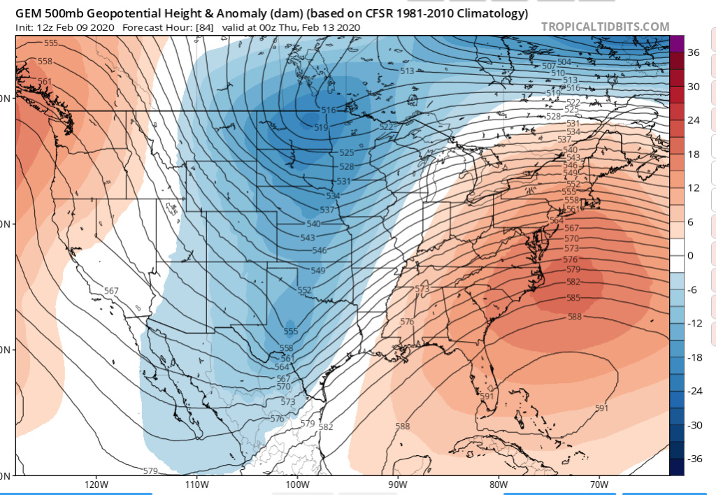
The guidance continues to show the huge ridge on east coast more and more like what the Euro is showing unfortunately. Today's 12Z GEM was extremely similar to the last Euro op run. The GFS is correcting to that too IMO and will be much closer to that in the next couple of runs. It's a bit stubborn, but it'll get there. This cuts IMO somewhere between Buffalo and Binghamton then slides east. That causes south westerly flow out ahead of it with no cold depth to the antecedent air mass. That'll make it difficult to get any accumulations outside of at least CNE and Upstate NY. Wow that is getting a bit redundant as i type this.
GEM 12Z Not quite as aggressive as the Euro, but awfully close.
heehaw453- Advanced Forecaster

- Posts : 3906
Reputation : 86
Join date : 2014-01-20
Location : Bedminster Township, PA Elevation 600' ASL
 Re: Long Range Thread 19.0
We could all use a typeitin prg. Just click for save phrases because everything is staying the same

dkodgis- Senior Enthusiast

- Posts : 2560
Reputation : 98
Join date : 2013-12-29
heehaw453- Advanced Forecaster

- Posts : 3906
Reputation : 86
Join date : 2014-01-20
Location : Bedminster Township, PA Elevation 600' ASL
 Re: Long Range Thread 19.0
We are counting on you Mr. Haw. It’s your opportunity to save winter. You can do it!

Grselig- Senior Enthusiast

- Posts : 1408
Reputation : 140
Join date : 2013-03-04
Age : 54
Location : Wayne NJ
Page 25 of 28 •  1 ... 14 ... 24, 25, 26, 27, 28
Page 25 of 28
Permissions in this forum:
You cannot reply to topics in this forum|
|
|

 Home
Home